Overview
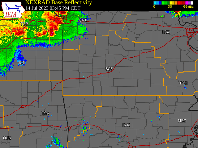
A thunderstorm complex with a destructive bow echo brought damaging wind with wind speeds of 70 to 80+ mph to parts of southeast Kansas and southwest Missouri during the afternoon and evening of July 14th, 2023.Photos & Video
 |
 |
 |
 |
Radar
Storm Reports
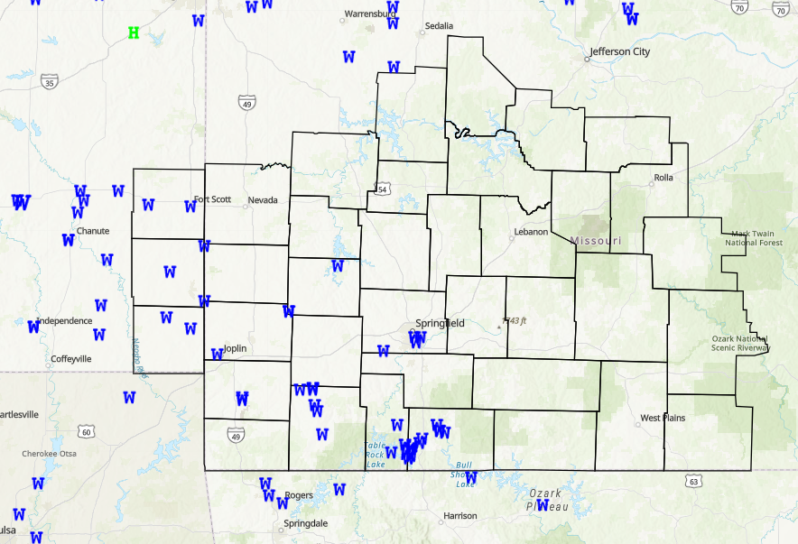
Preliminary Local Storm Report...Summary
National Weather Service Springfield MO
742 AM CDT Sat Jul 15 2023
..TIME... ...EVENT... ...CITY LOCATION... ...LAT.LON...
..DATE... ....MAG.... ..COUNTY LOCATION..ST.. ...SOURCE....
..REMARKS..
0632 PM Tstm Wnd Gst Arcadia 37.64N 94.62W
07/14/2023 E70 MPH Crawford KS Fire Dept/Rescue
Winds estimated 70 mph with damage and power
outages. Time based on radar.
0639 PM Tstm Wnd Gst 4 N Crestline 37.22N 94.71W
07/14/2023 M60 MPH Cherokee KS Broadcast Media
The line has just worked in, we have winds
right at 60 mph in central Cherokee County.
0735 PM Tstm Wnd Gst 3 SSW Pierce City 36.91N 94.01W
07/14/2023 M60 MPH Barry MO AWOS
Monett Airport wind gust of 60 mph.
0646 PM Tstm Wnd Gst 1 NE Airport Drive 37.15N 94.50W
07/14/2023 M54 MPH Jasper MO ASOS
ASOS station KJLN Joplin ASOS.
0815 PM Tstm Wnd Gst 2 W West Branson 36.70N 93.40W
07/14/2023 M54 MPH Stone MO AWOS
Branson West Airport.
0821 PM Tstm Wnd Gst 5 SSE Willard 37.24N 93.39W
07/14/2023 M53 MPH Greene MO ASOS
Springfield ASOS gusted to 53 mph at 821 pm.
0850 PM Tstm Wnd Gst 2 NNE Ridgedale 36.53N 93.20W
07/14/2023 M48 MPH Taney MO AWOS
AWOS station KBBG Branson AWOS.
1108 AM Rain 4 ESE Couch 36.58N 91.32W
07/14/2023 M5.60 inch Oregon MO Public
Delayed report from Thursday nights heavy
rain event.
1108 AM Rain 4 ESE Couch 36.58N 91.32W
07/14/2023 M5.60 inch Oregon MO Public
Delayed report from Thursday nights heavy
rain event.
1057 AM Rain 1 NW Thayer 36.53N 91.55W
07/14/2023 E4.63 inch Oregon MO CO-OP Observer
1100 AM Flash Flood 4 ESE Couch 36.58N 91.32W
07/14/2023 Oregon MO Public
Small creek rose rapidly and flood hay
fields and E Highway.
0610 PM Tstm Wnd Dmg Uniontown 37.85N 94.98W
07/14/2023 Bourbon KS Emergency Mngr
Round bales moved in the wind and power
lines down. Picture sent in email. Time
based on radar.
0620 PM Tstm Wnd Dmg Girard 37.51N 94.84W
07/14/2023 Crawford KS Fire Dept/Rescue
Several large tree limbs down and
transformers blown in Girard. Unknown size
other than large. Time based on radar.
0621 PM Tstm Wnd Dmg Carona 37.28N 94.86W
07/14/2023 Cherokee KS Public
Report from mPING: 1-inch tree limbs broken;
Shingles blown off.
0632 PM Tstm Wnd Dmg Fort Scott 37.84N 94.71W
07/14/2023 Bourbon KS Fire Dept/Rescue
Several roadways are blocked by trees with
many powerlines down. Time based on radar.
0636 PM Tstm Wnd Dmg 6 N Asbury 37.36N 94.62W
07/14/2023 Jasper MO Public
Report from mPING: 1-inch tree limbs broken;
Shingles blown off. Time based on radar.
0654 PM Tstm Wnd Dmg 2 W Joplin 37.09N 94.54W
07/14/2023 Jasper MO Public
Report from mPING: 3-inch tree limbs broken;
Power poles broken. Time based on radar.
0713 PM Tstm Wnd Dmg 1 WNW Neosho 36.87N 94.38W
07/14/2023 Newton MO Public
Report from mPING: 3-inch tree limbs broken;
Power poles broken.
0715 PM Tstm Wnd Dmg 1 SW Neosho 36.86N 94.38W
07/14/2023 Newton MO Public
Report from mPING: 3-inch tree limbs broken;
Power poles broken. Time based on radar.
0720 PM Tstm Wnd Dmg 1 ENE Dudenville 37.31N 94.08W
07/14/2023 Jasper MO Public
Report from mPING: 1-inch tree limbs broken;
Shingles blown off.
0732 PM Tstm Wnd Dmg 1 ENE Dudenville 37.31N 94.08W
07/14/2023 Jasper MO Public
Report from mPING: 3-inch tree limbs broken;
Power poles broken.
0735 PM Tstm Wnd Dmg Monett 36.91N 93.93W
07/14/2023 Barry MO Public
Report from mPING: 1-inch tree limbs broken;
Shingles blown off.
0740 PM Tstm Wnd Dmg 3 SW Cane Hill 37.54N 93.77W
07/14/2023 Dade MO Public
Report from mPING: 1-inch tree limbs broken;
Shingles blown off.
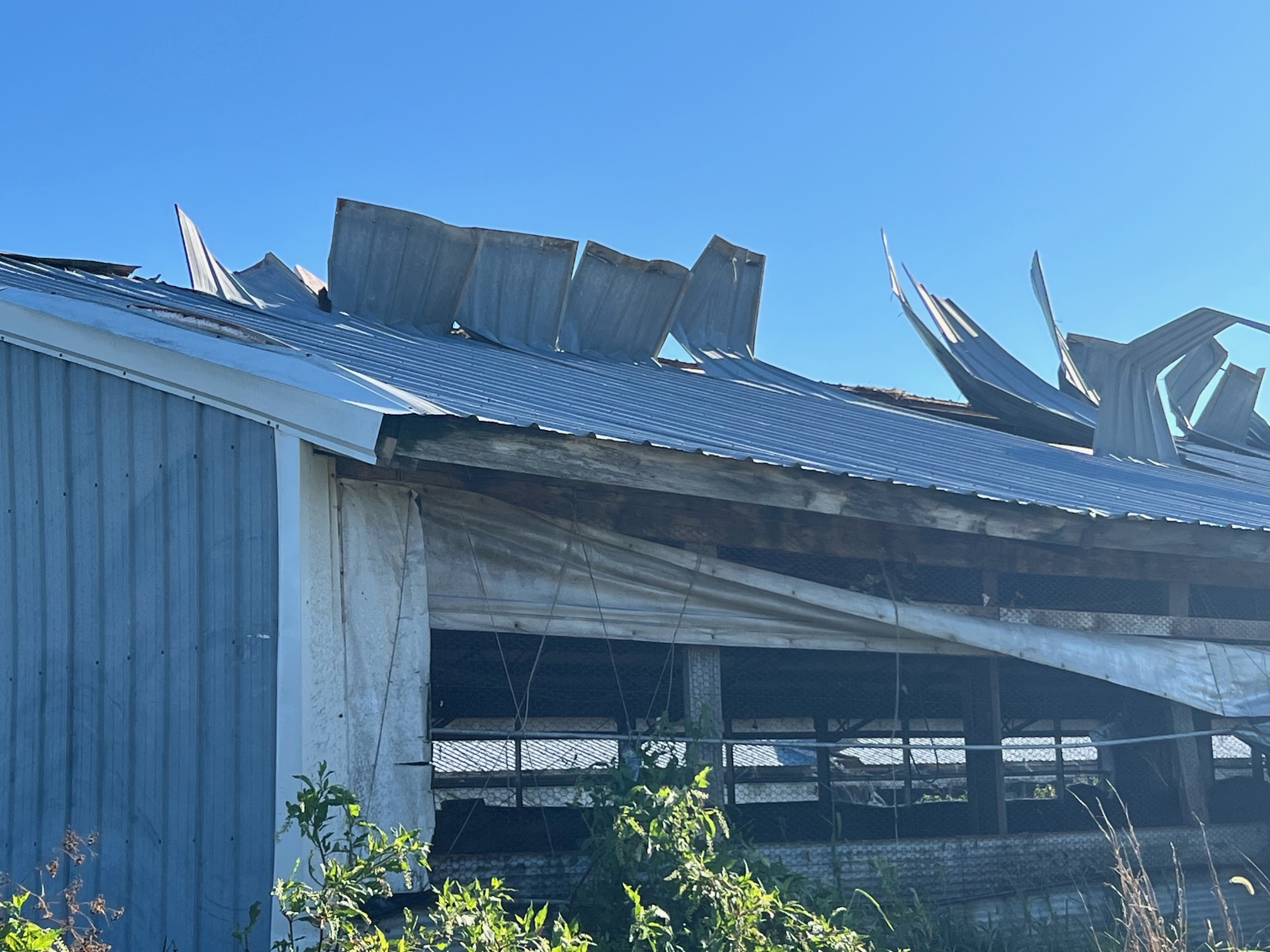
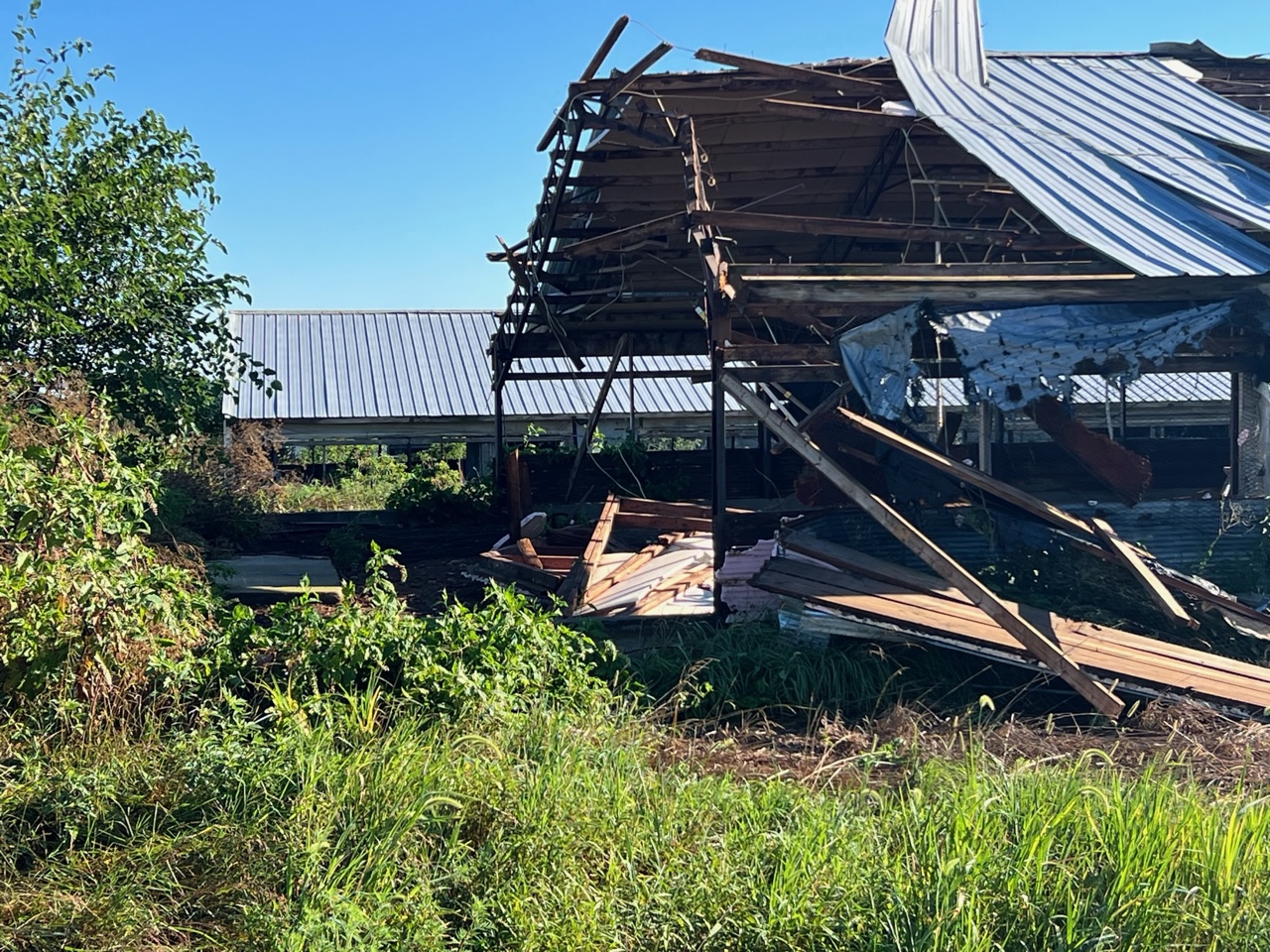
0742 PM Tstm Wnd Dmg 1 N Purdy 36.83N 93.92W
07/14/2023 Barry MO Law Enforcement
1 mile north of Purdy, multiple reports of a
roof blown off chicken houses, power lines
down, and large round hay bails blown across
the road.
0745 PM Tstm Wnd Dmg Cassville 36.68N 93.87W
07/14/2023 Barry MO Fire Dept/Rescue
Corrects previous tstm wnd dmg report from
Cassville. Small limb fell in front of door,
that an officer was able to move and free
the resident.
0800 PM Tstm Wnd Dmg Monett 36.92N 93.93W
07/14/2023 Barry MO Public
Fallen tree took out powerlines.
0812 PM Tstm Wnd Dmg 1 S Republic 37.11N 93.48W
07/14/2023 Greene MO Public
Report from mPING: 1-inch tree limbs broken;
Shingles blown off. Time based on radar.
0825 PM Tstm Wnd Dmg 1 NNE Table Rock 36.62N 93.29W
07/14/2023 Taney MO Fire Dept/Rescue
6 to 8 inch tree limbs down in the skyview
area.
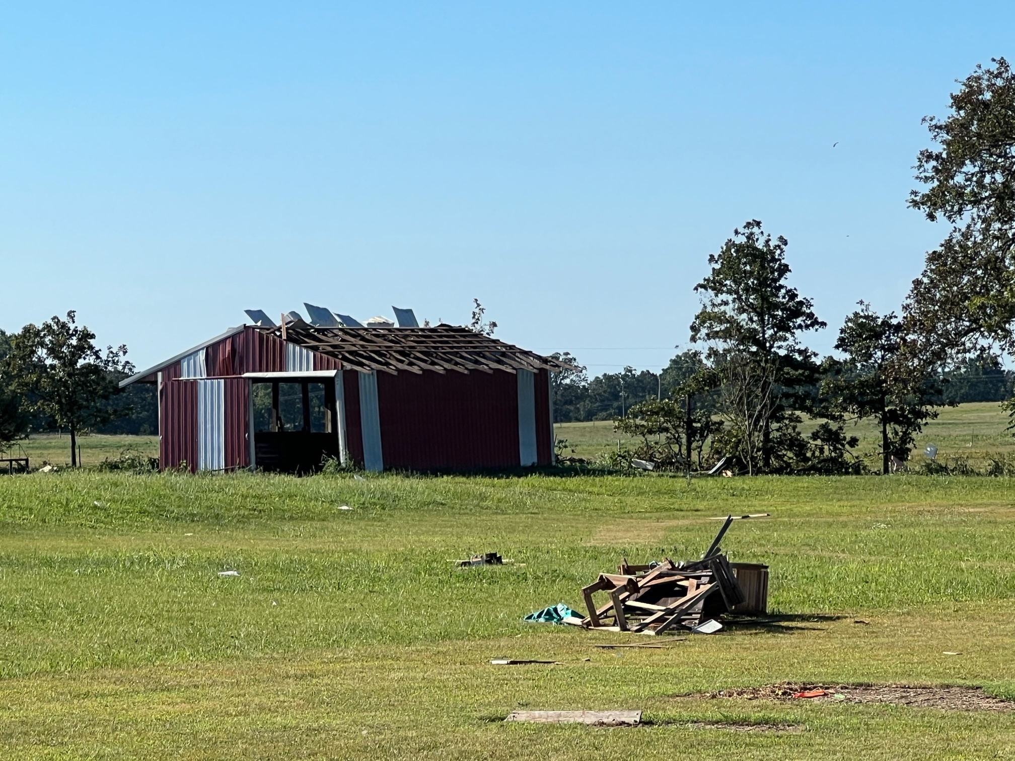
0825 PM Tstm Wnd Dmg 2 N Lampe 36.59N 93.43W
07/14/2023 Stone MO Emergency Mngr
Tree branches on roof and part of roof blew
off.
0830 PM Tstm Wnd Dmg 2 W Branson 36.64N 93.25W
07/14/2023 Taney MO Public
Report from mPING: 1-inch tree limbs broken;
Shingles blown off. Time based on radar.
0830 PM Tstm Wnd Dmg 2 W Branson 36.64N 93.25W
07/14/2023 Taney MO Public
Report from mPING: 1-inch tree limbs broken;
Shingles blown off. Time based on radar.
0830 PM Tstm Wnd Dmg 2 S Table Rock 36.57N 93.30W
07/14/2023 Taney MO Public
Pictures of trees down over the road.
0830 PM Tstm Wnd Dmg 3 SSW Table Rock 36.56N 93.32W
07/14/2023 Stone MO Emergency Mngr
Trailer tipped over.
0836 PM Tstm Wnd Dmg 2 ENE Merriam Woods 36.73N 93.14W
07/14/2023 Taney MO Public
Report from mPING: 1-inch tree limbs broken;
Shingles blown off. Time based on radar.
0837 PM Tstm Wnd Dmg 2 SSE Springfield 37.18N 93.28W
07/14/2023 Greene MO Amateur Radio
tree blocking roadway at National and
Seminole.
0838 PM Tstm Wnd Dmg 1 NNW Table Rock 36.61N 93.30W
07/14/2023 Taney MO Amateur Radio
Amateur radio reports several 2 to 3 inch
trees down.
0839 PM Tstm Wnd Dmg 2 WNW Galloway 37.15N 93.27W
07/14/2023 Greene MO Public
Report from mPING: 1-inch tree limbs broken;
Shingles blown off. Time based on radar.
0840 PM Tstm Wnd Dmg 1 N Forsyth 36.70N 93.12W
07/14/2023 Taney MO Amateur Radio
Amateur Radio reports 15 inch tree down on
Chishom Trail in Forsyth. Time based on
radar.
0840 PM Tstm Wnd Dmg 1 NNW Branson 36.66N 93.23W
07/14/2023 Taney MO Amateur Radio
Law enforcement reports numerous trees down
in Branson area. Time based on radar.
0842 PM Tstm Wnd Dmg 3 ESE Springfield 37.18N 93.24W
07/14/2023 Greene MO Public
Report from mPING: 1-inch tree limbs broken;
Shingles blown off. Time based on radar.
0843 PM Tstm Wnd Dmg 1 N Forsyth 36.70N 93.12W
07/14/2023 Taney MO Public
Report from mPING: 1-inch tree limbs broken;
Shingles blown off.
0900 PM Tstm Wnd Dmg 1 ENE Forsyth 36.69N 93.09W
07/14/2023 Taney MO Amateur Radio
power pole blown down and 2 to 3 inch limbs
down.
 |
Media use of NWS Web News Stories is encouraged! Please acknowledge the NWS as the source of any news information accessed from this site. |
|


 Weather Story
 Weather Map
 Local Radar