Overview
|
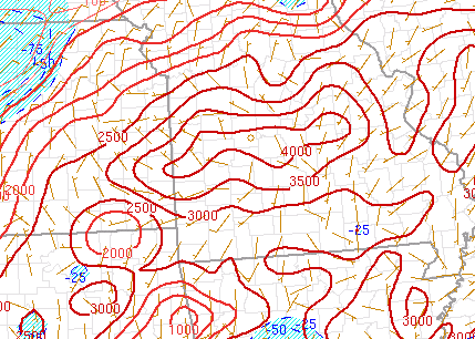
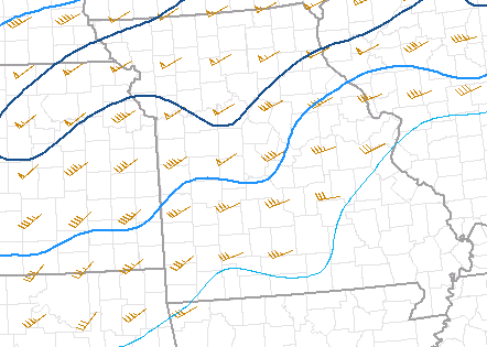
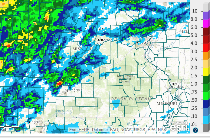
Strong to severe storms developed during the afternoon of August 25th, 2016, mainly along and north of the I-44 corridor in an area of strong instability and moderate deep layer shear. Most of the severe storms were from downburst type winds with a few large hail reports as well. Very heavy rainfall occurred with these storms which caused some localized flooding to occur. A small narrow band of 5 to 5.5 inches of rain occurred in southwestern Polk county which caused some flash flooding. |
 Caption |
 |
 |
|
| Surface Based CAPE 4 PM | Deep Layer Shear (0-6km) 4 PM |
Radar:

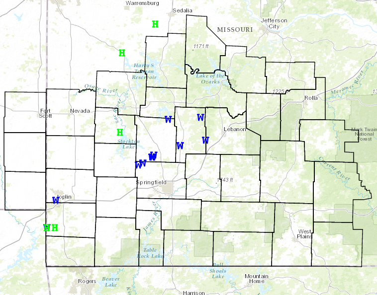
Storm Reports
PRELIMINARY LOCAL STORM REPORT...SUMMARY
NATIONAL WEATHER SERVICE SPRINGFIELD MO
1059 AM CDT FRI AUG 26 2016

..TIME...   ...EVENT...      ...CITY LOCATION...     ...LAT.LON...
..DATE...   ....MAG....      ..COUNTY LOCATION..ST.. ...SOURCE....
            ..REMARKS..

0432 PM     TSTM WND DMG     4 SE LEADMINE           37.81N 92.91W
08/25/2016                   DALLAS             MO   PUBLIC

            DELAYED REPORT... NUMEROUS TREE LIMBS DOWN ON PROPERTY
            AND PRIVATE ROADWAY INCLUDING HEALTHY 12 INCH DIAMETER
            WALNUT TREE LIMBS. TIME ESTIMATED VIA RADAR

0609 PM     TSTM WND DMG     JOPLIN                  37.08N 94.51W
08/25/2016                   JASPER             MO   LAW ENFORCEMENT

            TREES AND POWERLINES DOWN IN JOPLIN

0630 PM     TSTM WND DMG     2 SSW MORRISVILLE       37.46N 93.44W
08/25/2016                   POLK               MO   CO-OP OBSERVER

            TREE LIMB DOWN INTO POWER LINES

0720 PM     TSTM WND DMG     3 SSE PITTSBURG         37.79N 93.27W
08/25/2016                   POLK               MO   UTILITY COMPANY

            ELECTRIC COMPANY REPORTED VARIOUS LIMBS INTO POWERLINES
            AND SOME POWER LINE DAMAGE IN EASTERN AND NORTHEASTERN
            POLK COUNTY

0730 PM     TSTM WND GST     2 SW MORRISVILLE        37.46N 93.45W
08/25/2016  E60.00 MPH       POLK               MO   CO-OP OBSERVER

            SECOND SET OF DAMAGING WIND GUSTS ESIMATED AT 60 MPH
            OCCURED AT RESIDENCE OF COOP OBSERVER

0730 PM     TSTM WND DMG     SE FOOSE                37.56N 93.14W
08/25/2016                   DALLAS             MO   UTILITY COMPANY

            DELAYED REPORT...TREE LIMBS INTO POWERLINES AND SOME
            POWERLINE DAMAGE IN WESTERN DALLAS COUNTY. TIME ESTIMATED
            BY RADAR

0730 PM     HAIL             SE SENECA               36.84N 94.61W
08/25/2016  E1.00 INCH       NEWTON             MO   LAW ENFORCEMENT

0730 PM     TSTM WND DMG     SENECA                  36.84N 94.61W
08/25/2016                   NEWTON             MO   LAW ENFORCEMENT

            TREE LIMBS DOWN IN SENECA

0730 PM     HAIL             5 E SENECA              36.84N 94.52W
08/25/2016  E1.00 INCH       NEWTON             MO   LAW ENFORCEMENT

0746 PM     TSTM WND DMG     MORRISVILLE             37.48N 93.43W
08/25/2016                   POLK               MO   FIRE DEPT/RESCUE

            LOCAL FIRE DEPARTMENT OBSERVED MULTIPLE TREES DOWN IN
            MORRISVILLE FROM SEVERE THUNDERSTORM WIND GUSTS.

0812 PM     TSTM WND DMG     3 E LONG LANE           37.61N 92.86W
08/25/2016                   DALLAS             MO   UTILITY COMPANY

            DELAYED REPORT. ELECTRIC COMPANY HAD A FEW INSTANCES OF
            LIMBS INTO POWERLINES AND POWERLINE DAMAGE IN EASTERN
            PARTS OF DALLAS COUNTY. TIME ESTIMATED VIA RADAR

0825 PM     TSTM WND DMG     WALNUT GROVE            37.41N 93.55W
08/25/2016                   GREENE             MO   FIRE DEPT/RESCUE

            SEVERE THUNDERSTORM WIND GUSTS DOWNED SEVERAL LIMBS IN
            THE WALNUT GROVE AREA.

0840 PM     FLASH FLOOD      2 S EUDORA              37.45N 93.54W
08/25/2016                   POLK               MO   AMATEUR RADIO

            EXCESSIVE RAINFALL CAUSED FLASH FLOODING OVER A SECTION
            OF HIGHWAY 123 NORTH OF WALNUT GROVE AND SOUTH OF EUDORA.
            APPROXIMATELY 2 FEET OF WATER WAS FLOWING OVER THE
            HIGHWAY.

0848 PM     TSTM WND DMG     3 WSW WALNUT GROVE      37.39N 93.60W
08/25/2016                   GREENE             MO   PUBLIC

            DELAYED REPORT...WINDS ESTIMATED AT 60MPH ALSO HAD MINOR
            DAMAGE ON DECK

0852 PM     FLASH FLOOD      2 S EUDORA              37.45N 93.54W
08/25/2016                   POLK               MO   FIRE DEPT/RESCUE

            EXCESSIVE RAINFALL CAUSED FLASH FLOODING ALONG A SECTION
            OF HIGHWAY 123 SOUTH OF EUDORA. THIS SECTION OF 123 IS
            NEAR ITS INTERSECTION WITH COUNTY ROAD 560.

0910 PM     FLASH FLOOD      4 N WALNUT GROVE        37.48N 93.56W
08/25/2016                   POLK               MO   FIRE DEPT/RESCUE

            2 FEET OF WATER OVER STATE HIGHWAY W WEST OF EUDORA

0916 PM     HAIL             1 SSW STOCKTON          37.68N 93.80W
08/25/2016  E1.00 INCH       CEDAR              MO   PUBLIC

            QUARTER SIZE HAIL SOUTH SIDE OF STOCKTON

0925 PM     FLASH FLOOD      2 N WALNUT GROVE        37.44N 93.55W
08/25/2016                   POLK               MO   FIRE DEPT/RESCUE

            2 FEET OF WATER FLOWING OVER 560TH ROAD

0926 PM     FLASH FLOOD      2 NW WALNUT GROVE       37.43N 93.57W
08/25/2016                   POLK               MO   FIRE DEPT/RESCUE

            1 FOOT WATER FLOWING OVER FARM ROAD 2
Rain Reports
 |
Media use of NWS Web News Stories is encouraged! Please acknowledge the NWS as the source of any news information accessed from this site. |
|


 Weather Story
 Weather Map
 Local Radar