Overview
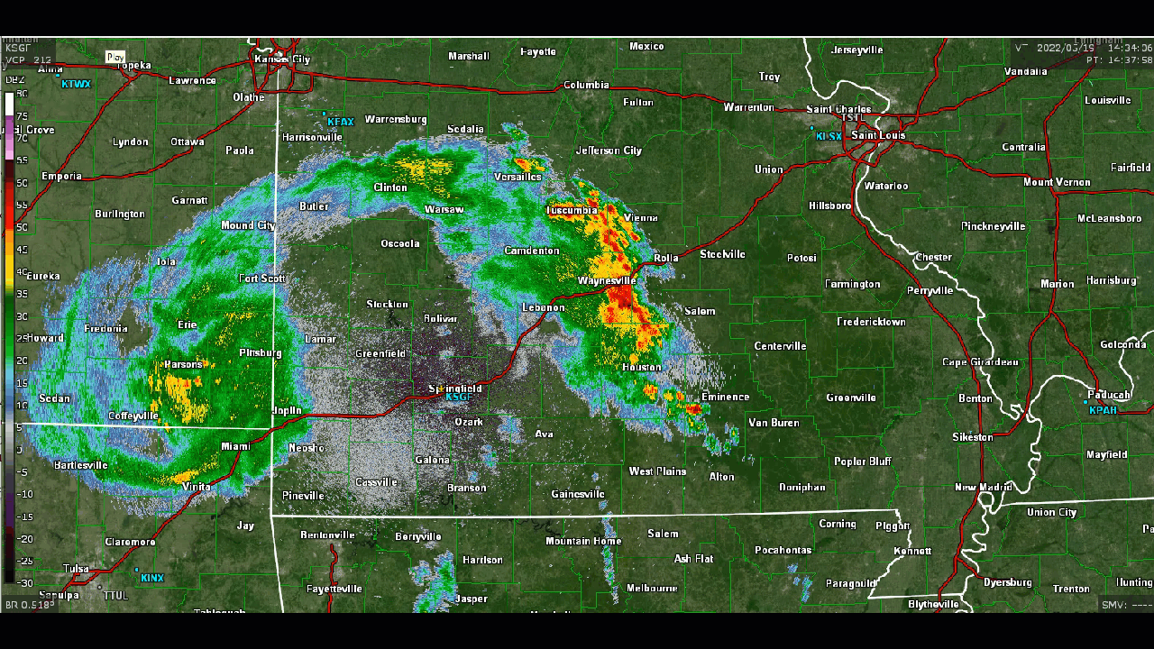
Severe storms tracked across portions of the Missouri Ozarks on Thursday May 19, 2022 producing wind damage across portions of the eastern Ozarks. Storm surveys concluded that two EF-1 tornadoes occurred in Phelps County on the afternoon of Thursday, May 19th.
Tornadoes:
|
Tornado - Beulah
Track Map  
|
||||||||||||||||||||||||
|
Tornado - North Lecoma
Track Map 
|
||||||||||||||||||||||||
The Enhanced Fujita (EF) Scale classifies tornadoes into the following categories:
| EF0 Weak 65-85 mph |
EF1 Moderate 86-110 mph |
EF2 Significant 111-135 mph |
EF3 Severe 136-165 mph |
EF4 Extreme 166-200 mph |
EF5 Catastrophic 200+ mph |
 |
|||||
Radar
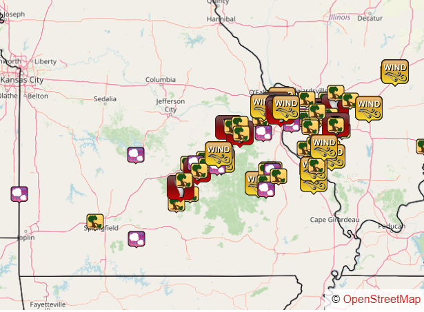
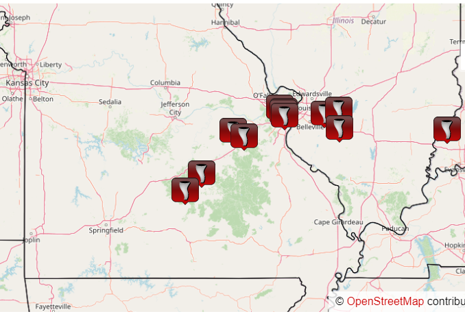
Storm Reports
All Severe and Tornado Reports From May 19, 2022
Just Tornado Reports From May 19, 2022
..TIME... ...EVENT... ...CITY LOCATION... ...LAT.LON...
..DATE... ....MAG.... ..COUNTY LOCATION..ST.. ...SOURCE....
..REMARKS..
0130 PM Heavy Rain 3 NNE Northview 37.32N 92.98W
05/19/2022 M1.96 inch Webster MO Mesonet
Corrects previous heavy rain report from 3
NNE Northview. Mesonet station CW2303 4 WSW
Marshfield. 3 hour total.
0214 PM Flood 1 N Northview 37.31N 92.99W
05/19/2022 Webster MO NWS Employee
Water flowing through low water crossing.
0245 PM Tstm Wnd Dmg 1 S Success 37.43N 92.08W
05/19/2022 Texas MO Public
High winds and wind damage were reported at
the Success School. A portion of the school
gymnasium wall was damaged. Report was
relayed by broadcast media.
0258 PM Tstm Wnd Dmg 3 N Licking 37.55N 91.86W
05/19/2022 Texas MO Amateur Radio
24 inch diameter tree down on Highway 63.
0502 PM Flood 5 SW Fort Leonard Wood 37.65N 92.21W
05/19/2022 Pulaski MO Public
Flooded creek near Cookville on Fort Leonard
Wood.
1017 AM Tstm Wnd Dmg 1 NW Saint James 38.00N 91.62W
05/19/2022 Phelps MO Law Enforcement
Report of a sign blown into the west-bound
lanes on I-44 at the 195 mile marker.
0246 PM Hail Rolla 37.95N 91.77W
05/19/2022 E0.70 inch Phelps MO Public
0254 PM Tornado 5 W Beulah 37.63N 92.01W
05/19/2022 Phelps MO NWS Storm Survey
A NWS storm survey concluded that an EF-1
tornado with peak winds of 90 mph destroyed
several small outbuildings along with
snapping and uprooting numerous trees. The
tornado path was 3 miles long with a maximum
width of 200 yards.
0255 PM Tstm Wnd Dmg 5 NW Beulah 37.67N 91.98W
05/19/2022 Phelps MO Law Enforcement
Damage to a home near county road 6610.
0301 PM Tstm Wnd Dmg 5 WNW Edgar Springs 37.73N 91.96W
05/19/2022 Phelps MO NWS Storm Survey
Delayed report. A National Weather Service
storm survey confirmed that straight line
winds downed multiple trees across County
Road 6380.
0319 PM Tornado 5 NNW Lecoma 37.85N 91.75W
05/19/2022 Phelps MO NWS Storm Survey
A NWS Storm Survey concluded that an EF-1
tornado, with peak winds of 90 mph, uprooted
numerous trees. A few trees were snapped.
Eyewitness report of rotation on the ground.
0320 PM Tstm Wnd Dmg 5 NNW Lake Spring 37.85N 91.71W
05/19/2022 Phelps MO Public
Several areas of wind damage reported in
between Lake Spring and Rolla near Highways
O and 72. Downed trees/powerlines and minor
house and barn damage were reported.
0324 PM Tstm Wnd Dmg Doolittle 37.94N 91.88W
05/19/2022 Phelps MO Emergency Mngr
Wind damage to a gas station.
0334 PM Tstm Wnd Dmg 6 SSE Saint James 37.92N 91.59W
05/19/2022 Phelps MO Public
Multiple downed and snapped trees along
County Road 3520 off of Highway F
south-southeast of St James.
0436 PM Flood 3 E Doolittle 37.94N 91.83W
05/19/2022 Phelps MO Public
Social media video showed flooding on Little
Beaver Creek near the Moose Lodge off of
Martin Springs Dr.
0436 PM Flood 3 E Doolittle 37.94N 91.83W
05/19/2022 Phelps MO Public
Flooding reported on Little Beaver Creek
near the Moose Lodge off of Martin Springs
Dr.
0400 PM Flood 5 WNW Competition 37.51N 92.52W
05/19/2022 Laclede MO Dept of Highways
Highway O was closed by MODOT due to
flooding.
0130 PM Tstm Wnd Dmg 6 NNW Battlefield 37.20N 93.40W
05/19/2022 Greene MO NWS Employee
Large tree downed.
0833 AM Lightning Goodhope 36.91N 92.81W
05/19/2022 Douglas MO Amateur Radio
Corrects previous lightning report from
Goodhope. House hit by lightning in
Goodhope. The fire department responded and
reported smoke only and possible place of
strike. House did not catch fire.
0835 AM Hail 4 WNW Ava 36.97N 92.73W
05/19/2022 M0.88 inch Douglas MO Amateur Radio
Nickel size hail at Y hwy and Cowskin Creek.
0115 PM Heavy Rain 2 E Masters 37.60N 93.62W
05/19/2022 M1.09 inch Cedar MO Mesonet
Mesonet station EW6435 Fair Play 3 hour
rainfall total.
0903 AM Hail 1 SSW Old Linn Creek 38.05N 92.74W
05/19/2022 M0.88 inch Camden MO Trained Spotter
Nickel size hail and 51 mph winds.
0642 AM Hail Mulberry 37.55N 94.62W
05/19/2022 U0.75 inch Crawford KS Public
Report from mPING: Dime (0.75 in.).
 |
Media use of NWS Web News Stories is encouraged! Please acknowledge the NWS as the source of any news information accessed from this site. |
|


 Weather Story
 Weather Map
 Local Radar