Overview
An intense storm system brought many forms of severe weather to the Missouri Ozarks and southeast Kansas over the time period Thursday, January 9th through Saturday, January 11th, 2020. The thunderstorms and heavy rain began across the eastern Ozarks on Thursday. Strong to severe thunderstorms developed along and ahead of a strong cold front on Friday which continued into Friday night. Damaging wind, hail and several tornadoes occurred on Friday and Friday night. As the system was lifting out of the area a Winter mix of freezing rain, sleet and snow occurred across most of the area.Tornadoes:
|
|
|||||||||
|
|||||||||
|
Tornado - NE Springfield - Strafford
|
||||||||||||||||
|
Tornado - SW to N of Fair Play
|
||||||||||||||||
|
Tornado -Near Cross Timbers
|
||||||||||||||||
The Enhanced Fujita (EF) Scale classifies tornadoes into the following categories:
| EF0 Weak 65-85 mph |
EF1 Moderate 86-110 mph |
EF2 Significant 111-135 mph |
EF3 Severe 136-165 mph |
EF4 Extreme 166-200 mph |
EF5 Catastrophic 200+ mph |
 |
|||||
Flooding
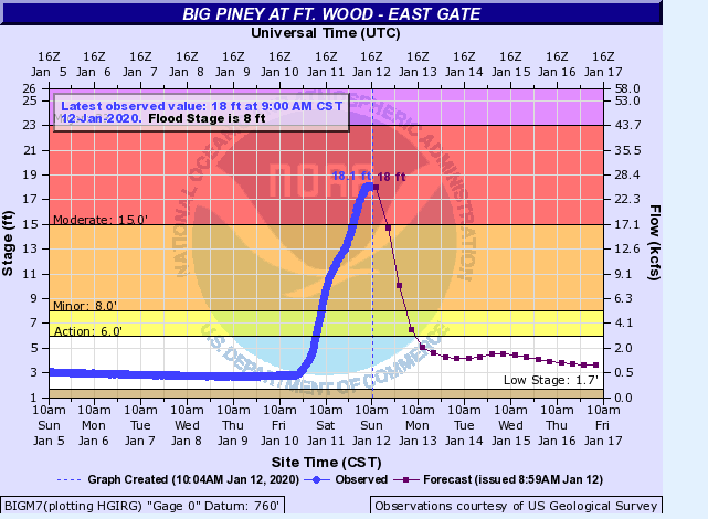
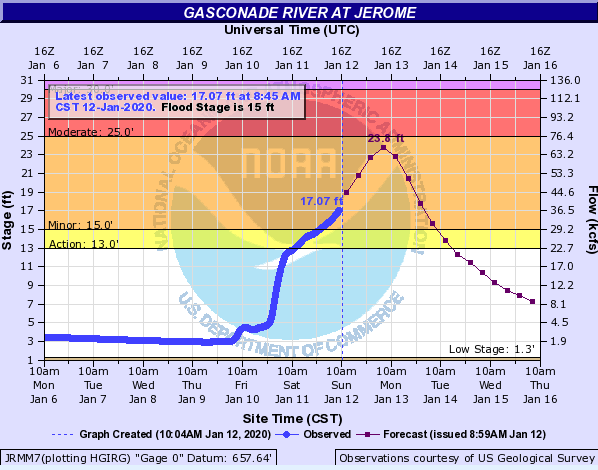
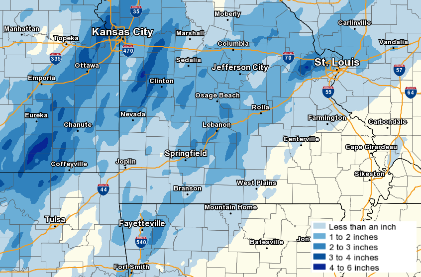
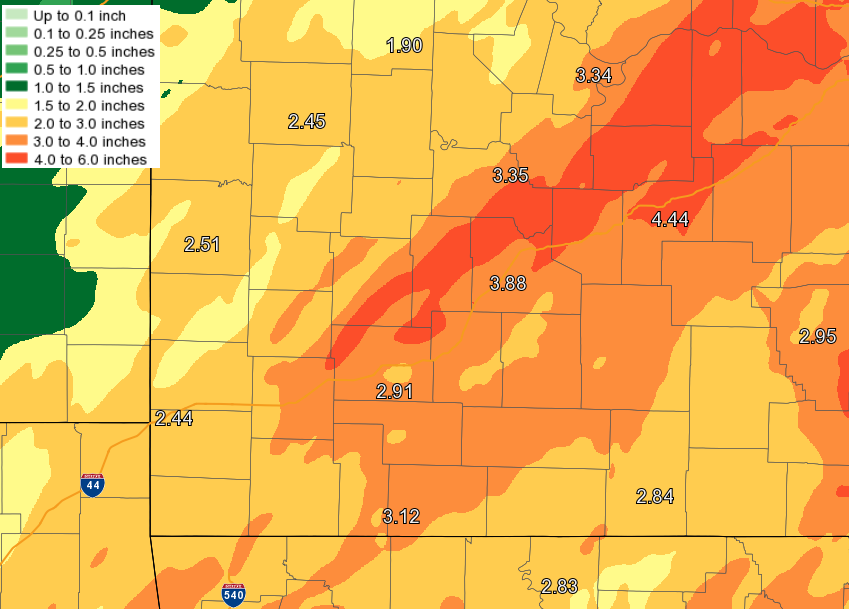
Two to over four inches of rain occurred across the area from Thursday into Saturday morning across the area. This led to quite a bit of flooding and flash flooding across the area. Many rivers went above flood stage.
Hydrographs
 |
 |
 |
 |
| Big Piney River @ Ft. Leonard Wood | Gasconade River @ Jerome | James River @ Galena | Marmaton River @ Nevada |
Additional flooding
 |
|||
| Road closures in MO from flooding |
Snow/Ice
As the system was lifting out on Saturday, freezing drizzle changed to sleet and snow before precipitation ended across the area. General snowfall amounts were in the 1 to 2 inch range. Some isolated 3 to 4 inch amounts occurred in central MO.
Radar
Fair Play Tornado - 2:34 PM
 |
 |
 |
|
| Fair Play Tornado - Reflectivity 2:34 PM | Fair Play Tornado - Storm Relative Velocity 2:34 PM | Fair Play Tornado - Correlation Coefficient 2:34 PM |
Strafford Tornado - 5:51 PM
 |
 |
 |
|
| Strafford Tornado - Reflectivity | Strafford Tornado - Storm Relative Velocity | Strafford Tornado - Correlation Coefficient |
Near Cross Timbers Tornado - 3:20 PM
 |
 |
 |
|
| Near Cross Timbers Tornado - Reflectivity | Near Cross Timbers Tornado - Storm relative velocity | Near Cross Timbers Tornado - Correlation Coefficient |
Storm Reports
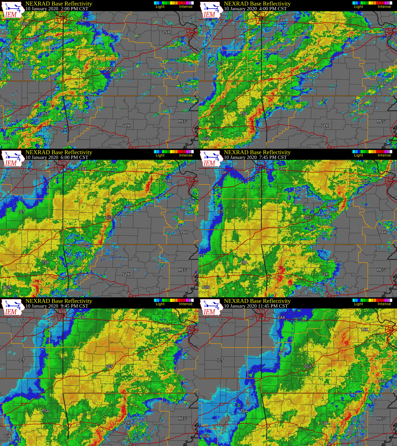
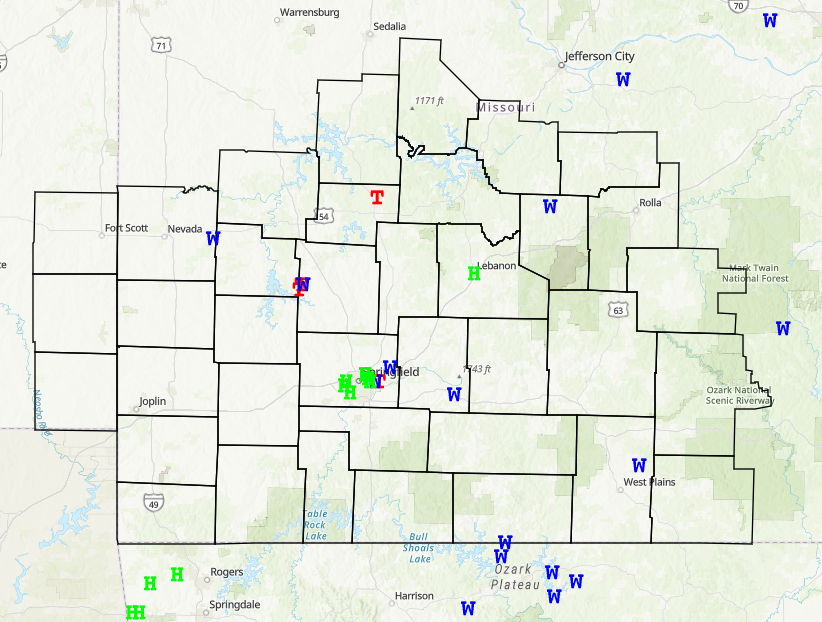
Thunderstorms developed along and ahead of the cold front on Friday. Several reports of wind damage and hail occurred, along with three tornadoes.
Rain Reports
Rainfall started during the day Thursday and continued into Saturday morning. General rain amounts of 2 to 4 inches occurred, with some localized areas receiving over 4 inches.
 |
Media use of NWS Web News Stories is encouraged! Please acknowledge the NWS as the source of any news information accessed from this site. |
 |