 |
Winter Storm March 1-3, 2014National Weather Service, Springfield, MO |
 |
March came in like a lion as a winter storm impacted a large portion of the central United States from Saturday night through early Monday morning. Precipitation began as a mixture of freezing rain and sleet Saturday night across much of the area, with rain changing to freezing rain and sleet across far southern Missouri as the night progressed. Many locations across southern Missouri also saw thunderstorms Saturday night with numerous reports of thunder-sleet!
Occasional light snow and sleet were then common across the region for much of Sunday, with heavier sleet and thunderstorms continuing Sunday morning across far southern Missouri. We even received a report of penny-sized hail across southeastern Taney County near the town of Rueter! Meanwhile, temperatures on Sunday plunged through the twenties and teens as an Arctic air mass oozed south into the region. High temperatures actually occurred right after midnight over all areas on Sunday.
Precipitation then increased in intensity Sunday night as the final wave of this prolonged storm system moved across the region. Precipitation changed over to primarily snow by late Sunday evening, with moderate to heavy snow impacting southern Missouri from late Sunday night into early Monday morning. With temperatures continuing to fall into the single digits, a very dry and fluffy snow fell across the Ozarks. Brisk northerly winds and the falling snow also produced considerable blowing and drifting of snow across southern Missouri.
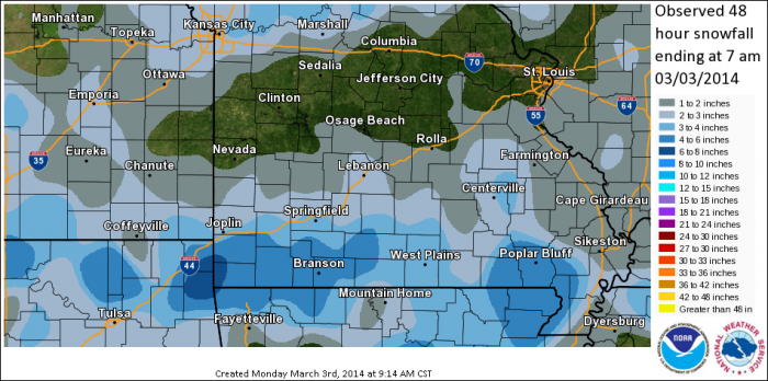
Storm total sleet and snow accumulations varied considerably across the Ozarks with portions of central Missouri receiving very little snowfall. In contrast, areas along and south of U.S. Highway 60 saw 3-6", with localized amounts approaching 8" across far southwestern Missouri. Meanwhile, ice accumulations across the area were held down due to a fairly quick changeover to sleet. Most areas saw a thin glaze of ice, with a few reports of around 1/8" of freezing rain across south-central Missouri.
This map depicts combined snow and sleet amounts through 7 AM Monday morning. Some locations across south-central Missouri did see additional light snowfall after 7 AM Monday morning.
...PRELIMINARY SNOW AND SLEET AMOUNTS FROM LATE WEEKEND WINTER
STORM...

THE TOTALS BELOW ARE SEPARATED INTO SNOW...AND ICE AND SLEET
CATEGORIES...THEN BY AMOUNT...AND ARE NOT NECESSARILY THE
FINAL AMOUNT FOR EACH LOCATION.


SNOW REPORTS LISTED BY AMOUNT

 INCHES  LOCATION                 ST  COUNTY           TIME
 ------  -----------------------  --  --------------   -------
  6.50   3 W REEDS SPRING         MO  STONE            0533 AM
                 STORM TOTAL 6.5 INCHES OF SNOW AND SLEET.
                 PASSED ON BY BROADCAST MEDIA VIA TWITTER.
  5.00   5 NW KIMBERLING CITY     MO  STONE            0757 AM
                 5 INCHES OF NEW SNOW ON TOP OF 0.6 INCH OF
                 SLEET ACCUMULATION FROM YESTERDAY.
  4.00   1 N SEYMOUR              MO  WEBSTER          0940 AM
  4.00   8 N DORA                 MO  DOUGLAS          0842 AM
                 SNOW ON TOP OF 1.5 INCHES OF SLEET.
  4.00   4 NNE WHITE CHURCH       MO  HOWELL           0749 AM
                 4 INCHES OF NEW SNOW ON TOP OF 1 INCH OF
                 SLEET THAT FELL YESTERDAY.
  4.00   5 SE CASSVILLE           MO  BARRY            0715 AM
                 4 INCHES OF SNOW ON TOP OF 3/4 INCH OF SLEET.
  3.80   1 NW VERONA              MO  LAWRENCE         0601 AM
  3.20   WEBB CITY                MO  JASPER           0414 AM
                 APPROX. 0.8 INCHES OF SLEET AND 3.2 INCHES OF
                 SNOW MEASURED NEAR WEBB CITY. STORM TOTAL OF
                 4.0 INCHES OF COMBINED SLEET AND SNOW.
  3.00   2 S WEST PLAINS          MO  HOWELL           0953 AM
                 ONE INCH SLEET IN WEST PLAINS AND THREE
                 INCHES OF SLEET SOUTH OF WEST PLAINS.
  3.00   5 S SPRINGFIELD          MO  GREENE           0907 AM
  3.00   DORA                     MO  OZARK            0734 AM
                 3 INCHES OF NEW SNOW ON TOP OF 2 INCHES OF
                 SLEET THAT FELL YESTERDAY.
  3.00   4 SE CASSVILLE           MO  BARRY            0525 AM
                 3 INCHES OF SNOW AND 0.5 INCHES OF SLEET.
  2.80   5 NW SPRINGFIELD         MO  GREENE           0412 AM
                 2.8 INCHES OF SNOW SINCE MIDNIGHT AT THE
                 SPRINGFIELD NWS OFFICE. STORM TOTAL 3.8
                 INCHES OF SNOW AND SLEET.
  2.50   ASH GROVE                MO  GREENE           0749 AM
                 2.5 INCHES OF NEW SNOW ON TOP OF 1/2 INCH OF
                 SLEET THAT FELL YESTERDAY.
  1.70   3 NE FAIR GROVE          MO  GREENE           0715 AM
                 1.7 INCHES OF SNOW ON TOP OF 1/4 INCH OF
                 SLEET.
  1.50   2 NE BOLIVAR             MO  POLK             1239 AM
                 1.5 INCHES OF NEW SNOW IN THE LAST HOUR.
  1.00   NIANGUA                  MO  WEBSTER          0715 AM
                 1.0 INCH OF SNOW ON TOP OF 1/2 INCH OF SLEET.
  0.50   3 E FLEMINGTON           MO  POLK             0737 AM
                 1/2 INCH OF SNOW ON TOP OF 1 INCH OF SLEET
                 THAT FELL YESTERDAY.
  0.50   CAMDENTON                MO  CAMDEN           0341 AM
                 1.0 INCH OF SLEET ON 3/2...WITH AN ADDITIONAL
                 0.5 INCH OF SNOW ON 3/3. STORM TOTAL OF 1.5
                 INCHES OF SLEET AND SNOW.


SLEET AND FREEZING RAIN REPORTS LISTED BY AMOUNT

 INCHES  LOCATION                 ST  COUNTY           TIME
 ------  -----------------------  --  --------------   -------
  1.00   FORT LEONARD WOOD        MO  PULASKI          0734 AM
                 STORM TOTAL OF ONE INCH OF SLEET.


 Weather Story
 Weather Map
 Local Radar