Springfield, MO
Weather Forecast Office
 |
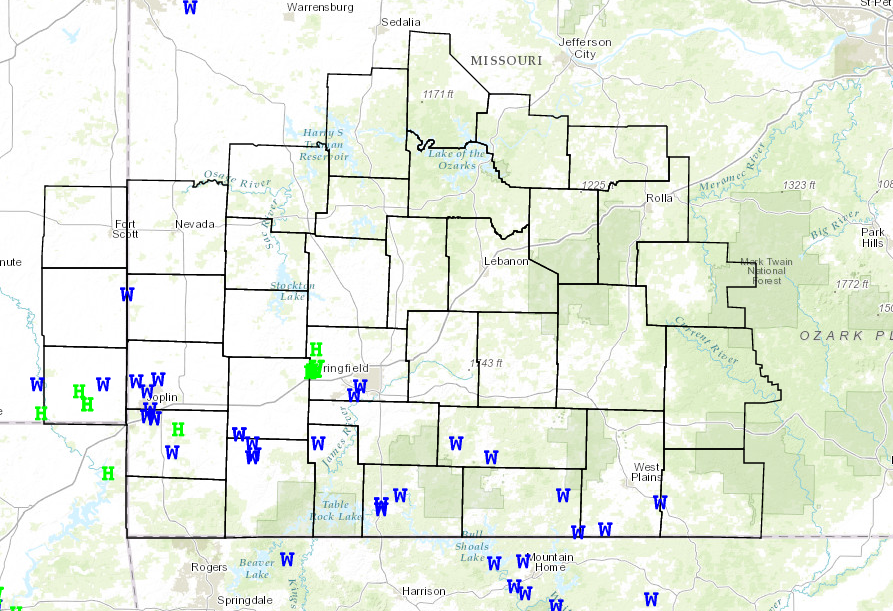
Severe Storms and Flooding June 5th and 6th, 2014National Weather Service, Springfield, MO |
 |
A complex of thunderstorms developed over eastern Kansas during the overnight hours of June 5th and tracked across extreme southeast Kansas and southern Missouri during the morning of June 6th. Numerous reports of 50 to 70 mph winds were received as a large bow echo raced through the region causing some scattered wind damage reports. In addition, very heavy rainfall occurred with this thunderstorm complex which caused some flash flooding to occur, especially in areas which had received heavy rainfall the evening before. There were several reports in Jasper county of 6 to 10 inches of rainfall.
Scattered severe thunderstorms then developed across northeastern Oklahoma and pushed into extreme southeastern Kansas and southwestern Missouri late Thursday evening. Some of these storms produce hail up to the size of golf balls. Torrential rainfall and nearly continuous lightning also occurred with these storms. Reports of flash flooding were received from McDonald County.


Current Hazards
Experimental Graphical Hazardous Weather Outlook
Submit a storm report
Local Storm Reports
Current Conditions
Observations
Lake Levels
Snowfall Analysis
Road Conditions
Satellite
CoCoRaHS
Graphical Conditions
Precip. Analysis
Forecasts
Forecast Discussion
Fire Weather
Aviation
GIS Forecast Maps
Activity Planner
Severe Weather
Winter Weather
Hurricanes
FAA Center Weather
Space Weather
Climatology
Records and Normals
Monthly Climate Summary
Local
National
Drought
Climate Science
Astronomical Data
US Dept of Commerce
National Oceanic and Atmospheric Administration
National Weather Service
Springfield, MO
Springfield-Branson National Airport
5805 West Highway EE
Springfield, MO 65802-8430
Business: 417-863-8028 Recording: 417-869-4491
Comments? Questions? Please Contact Us.


 Weather Story
 Weather Map
 Local Radar