 |
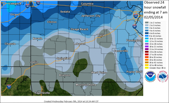
Snowfall on February 4th, 2014
National Weather Service, Springfield, MO
|
 |
A storm system brought moderate to occasionally heavy snow to the Missouri Ozarks and extreme southeastern Kansas on February 4th and 5th. The snow started over most areas Tuesday morning, with portions of central Missouri not seeing snow until early Tuesday afternoon. Once the snow started, it came down rather heavily for a time with roads quickly becoming snow covered and hazardous.
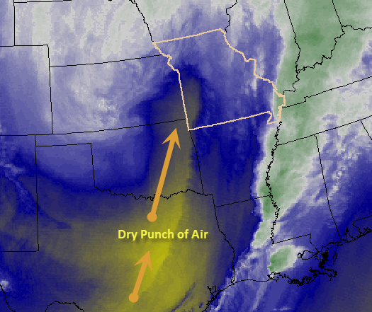
The snow then tapered off over many areas from later Tuesday afternoon into early Tuesday evening as dry air in the middle and upper portions of the atmosphere punched northward into the region. Patchy freezing drizzle also developed as this "dry slot" moved into the area. Bands of snow then re-developed from Tuesday evening into Wednesday morning as the main upper level storm system moved over the region.
Total snowfall amounts from Tuesday morning into Wednesday morning generally ranged from 1 to 4 inches with locally higher amounts occurring north of the Highway 54 corridor in central Missouri. Several locations also saw a thin glaze of ice due to the patchy freezing drizzle.
Event Maps
Event Reports
...Snow and Sleet Totals from Latest Winter Storm...

THE TOTALS BELOW ARE SEPARATED INTO SNOW...AND ICE AND SLEET
CATEGORIES...THEN BY AMOUNT...AND ARE NOT NECESSARILY THE
FINAL AMOUNT FOR EACH LOCATION.

 INCHES  LOCATION                 ST  COUNTY           TIME
 ------  -----------------------  --  --------------   -------
  5.00   3 NW COLE CAMP           MO  BENTON           0622 AM
  5.00   VERSAILLES               MO  MORGAN           0930 AM
  4.00   2 NE RIDGEDALE           MO  TANEY            0914 AM
                 MEASURED AT BRANSON AIRPORT.
  3.50   6 W EDWARDS              MO  BENTON           0722 AM
  3.50   APPLETON CITY            MO  ST. CLAIR        0550 AM
  3.00   1 N SEYMOUR              MO  WEBSTER          0943 AM
  3.00   WHITE CHURCH             MO  HOWELL           0909 AM
  3.00   4 W LAURIE               MO  MORGAN           0822 AM
  3.00   GRAVOIS MILLS            MO  MORGAN           0707 AM
  3.00   FORT LEONARD WOOD        MO  PULASKI          0706 AM
  2.70   4 W WINDYVILLE           MO  DALLAS           0743 AM
  2.50   ROUND SPRING             MO  SHANNON          0832 AM
                 SOME SLEET MIXED IN.
  2.50   ASH GROVE                MO  GREENE           0802 AM
  2.50   1 W SARCOXIE             MO  JASPER           0731 AM
  2.50   5 NW KIMBERLING CITY     MO  STONE            0716 AM
  2.30   3 NE FAIR GROVE          MO  GREENE           0814 AM
  2.30   NIANGUA                  MO  WEBSTER          0714 AM
  2.30   3 NW SPRINGFIELD         MO  GREENE           0550 AM
                 MEASURED AT NWS OFFICE.
  2.00   3 S WASOLA               MO  OZARK            0852 AM
  2.00   MORRISVILLE              MO  POLK             0745 AM
  2.00   1 SE MORGAN              MO  LACLEDE          0711 AM
  2.00   5 SE CASSVILLE           MO  BARRY            0659 AM
                 ROARING RIVER STATE PARK.
  1.60   BUFFALO                  MO  DALLAS           0741 AM
  1.50   DORA                     MO  OZARK            0722 AM
  1.40   4 W PITTSBURG            MO  HICKORY          0718 AM


 Weather Story
 Weather Map
 Local Radar