 |
Snowfall - March 21st, 2013National Weather Service, Springfield, MO |
 |
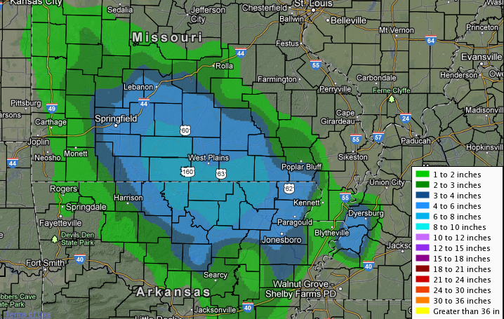
A quick moving upper level system brought some heavy snow to the Missouri Ozarks late Thursday into Thursday night March 21st. The heaviest bands occurred after dark as a low level jet developed into the region. There were a few reports of thundersnow across southern Missouri during the evening as some convective bands developed which brought snowfall rates into the 1.5 to 2.0 inch per hour amount.
The greatest snow accumulations fell across far southern Missouri south of a line from bolivar to Fort Leonard Wood where totals of 3 to 6 inches were common. Higher accumulations ranging from 7 to 10 Inches occurred across far south central Missouri including portions of Webster...Wright...Texas...Howell...Douglas...and Ozark counties. Snow accumulations were less across the remainder of the Missouri Ozarks and far southeastern Kansas where totals ranged from a trace to around 2 inches.
The following is a listing of snow accumulations from volunteer and cooperative observers across southeast Kansas and the Missouri Ozarks. Some of the reports do not represent final storm totals.
SNOW
INCHES LOCATION ST COUNTY TIME
------ ----------------------- -------------- -------
10.80 LANTON MO HOWELL 1157 AM
9.00 TECUMSEH MO OZARK 0700 AM
8.5 13.6 SSE AVA MO DOUGLAS 0700 AM
7.7 4.5 SSE HOUSTON MO TEXAS 0700 AM
7.50 CAULFIELD MO HOWELL 1107 PM
7.4 3.7 SSE MANSFIELD MO WEBSTER 0700 AM
7.00 9 E CONWAY MO LACLEDE 0700 AM
7.00 WEST PLAINS MO HOWELL 1151 PM
7.00 WHITE CHURCH MO HOWELL 0700 AM
7.00 MANSFIELD MO WRIGHT 1108 PM
7.00 MARSHFIELD MO WEBSTER 1108 PM
7.00 GAINESVILLE MO OZARK 1052 PM
7.00 HARTVILLE MO WRIGHT 1039 PM
7.00 WASOLA MO OZARK 1022 PM
7.00 MANES MO WRIGHT 1018 PM
6.80 2.6 NNW DORA MO OZARK 0700 AM
6.50 WILLOW SPRINGS MO HOWELL 1022 PM
6.00 3 NE PROTEM MO TANEY 0700 AM
6.00 OZARK MO CHRISTIAN 1234 AM
6.00 AVA MO DOUGLAS 1151 PM
6.00 LICKING MO TEXAS 1030 PM
6.00 LICKING MO TEXAS 1030 PM
6.00 MARSHFIELD MO WEBSTER 1022 PM
6.00 FAIR GROVE MO GREENE 1018 PM
6.00 NORWOOD MO WRIGHT 0953 PM
6.00 MORRISVILLE MO POLK 0945 PM
5.50 ROME MO DOUGLAS 1059 PM
5.50 4 N FORDLAND MO WEBSTER 1047 PM
5.50 COMPETITION MO LACLEDE 0953 PM
5.20 3.3 E BATTLEFIELD MO GREENE 0700 AM
5.00 YUKON MO TEXAS 1234 AM
5.00 ROGERSVILLE MO WEBSTER 1116 PM
5.00 BRANSON MO TANEY 1059 PM
5.00 3 SSW SPRINGFIELD MO GREENE 1041 PM
5.00 PEACE VALLEY MO HOWELL 1033 PM
5.00 LAQUEY MO PULASKI 1015 PM
5.00 WEST PLAINS MO HOWELL 1002 PM
5.00 6 S SPRINGFIELD MO GREENE 0940 PM
5.00 5 NNW MARSHFIELD MO WEBSTER 0740 PM
5.00 NIANGUA MO WEBSTER 0717 PM
5.00 MOUNTAIN GROVE MO WRIGHT 0700 PM
4.60 HARTVILLE MO WRIGHT 0700 AM
4.50 4 S ROGERSVILLE MO CHRISTIAN 1033 PM
4.50 3 ESE SPRINGFIELD MO GREENE 1015 PM
4.50 AVA MO DOUGLAS 1015 PM
4.50 BRANSON MO TANEY 0900 PM
4.50 FORDLAND MO WEBSTER 0653 PM
4.00 EMINENCE MO SHANNON 0700 AM
4.00 2.8 SW WINONA MO SHANNON 0700 AM
4.00 BATTLEFIELD MO GREENE 1000 PM
4.00 4 W SPRINGFIELD MO GREENE 0939 PM
4.00 ROBY MO TEXAS 0824 PM
4.00 LEBANON MO LACLEDE 0702 PM
3.80 MARSHFIELD MO WEBSTER 0700 AM
3.80 BRANSON AIRPORT MO TANEY 0700 AM
3.50 RICHLAND MO PULASKI 1059 PM
3.50 N IXA MO CHRISTIAN 1052 PM
3.50 LEBANON MO LACLEDE 1018 PM
3.2 2.4 NW GALENA MO STONE 0700 AM
3.00 NWS SPRINGFIELD MO GREENE 0100 AM
3.00 DADEVILLE MO DADE 0700 AM
3.00 ASH GROVE MO GREENE 0700 AM
3.00 PLATO MO TEXAS 1107 PM
3.00 2 N BUFFALO MO DALLAS 0700 AM
3.00 MANSFIELD MO WRIGHT 0527 PM
2.70 ROLLA MO PHELPS 0700 AM
2.50 SHELL KNOB MO BARRY 1003 PM
2.00 JERICO SPRINGS MO PHELPS 0700 AM
2.50 MARSHFIELD MO WEBSTER 0524 PM
2.00 3 NE HALLTOWN MO GREENE 0747 PM
2.00 4 W PITTSBURG MO HICKORY 0731 PM
2.00 FALCON MO LACLEDE 0659 PM
2.00 SPRINGFIELD MO GREENE 0515 PM
1.80 LOCKWOOD MO DADE 0700 AM
1.50 MOUNTAIN VIEW MO HOWELL 0612 PM
1.50 APPLETON CITY MO ST. CLAIR 0700 AM
COUNTY SUMMARY...
COUNTY SNOW
KANSAS:
BOURBON TRACE
CRAWFORD TRACE
CHEROKEE TRACE
MISSOURI:
VERNON TRACE TO 2 INCHES
BARTON TRACE TO 1 INCH
JASPER TRACE TO 1 INCH
NEWTON TRACE TO 1 INCH
MCDONALD TRACE TO 1 INCH
ST. CLAIR 1 TO 3 INCHES
CEDAR 1 TO 3 INCHES
DADE 1 TO 4 INCHES
LAWRENCE 1 TO 3 INCHES
BARRY 1 TO 3 INCHES
STONE 2 TO 5 INCHES
CHRISTIAN 3 TO 7 INCHES
GREENE 3 TO 6 INCHES
POLK 2 TO 6 INCHES
HICKORY 1 TO 3 INCHES
BENTON 1 TO 2 INCHES
MORGAN TRACE TO 2 INCHES
CAMDEN 1 TO 3 INCHES
MILLER TRACE TO 2 INCHES
DALLAS 2 TO 6 INCHES
WEBSTER 4 TO 7 INCHES
TANEY 3 TO 7 INCHES
MARIES TRACE TO 1 INCH
LACLEDE 3 TO 7 INCHES
WRIGHT 4 TO 7 INCHES
DOUGLAS 6 TO 9 INCHES
OZARK 6 TO 10 INCHES
HOWELL 5 TO 10 INCHES
TEXAS 4 TO 7 INCHES
PULASKI 1 TO 4 INCHES
PHELPS 1 TO 3 INCHES
DENT 1 TO 3 INCHES
SHANNON 3 TO 7 INCHES
OREGON 3 TO 7 INCHES


 Weather Story
 Weather Map
 Local Radar