 |
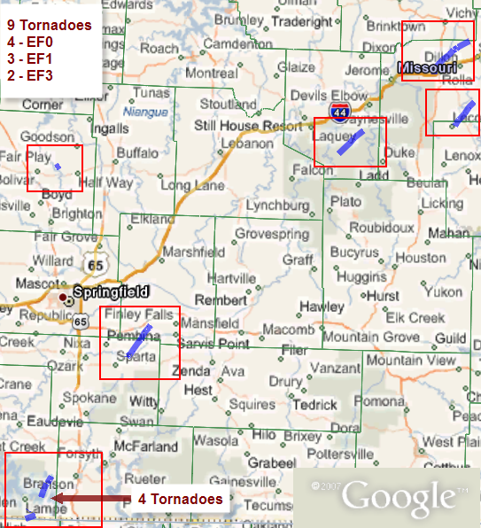
Deadly Tornadoes - December 31st, 2010National Weather Service, Springfield, MO |
 |
Two rounds of severe weather impacted the Ozarks during the morning hours of New Year's Eve 2010. The first round arrived shortly after midnight as a pair of supercell thunderstorms moved northeast out of northern Arkansas into south central Missouri, producing tornadoes near Indian Point in Stone County and in northern Christian and southern Webster Counties.
Round two arrived shortly after daybreak as supercells again developed ahead of a dryline over northern Arkansas, moving northeast into Missouri. These storms produced tornadoes once again near Indian Point in Stone County, northeast of Bolivar, and near Ft. Leonard Wood, Rolla, and the town of Lecoma in Dent County. Tragically, these tornadoes claimed two lives north of Rolla and two more near Lecoma.
These tornadoes ranged in intensity from EF-0 to EF-3 with four of EF-0 intensity, three EF-1, and two EF-3.
Please note: The tornado counts, strength, and tracks on these pages are preliminary, and subject to change as additional storm surveys are completed. Additional information on this and other aspects of the event will be provided as soon as it is available.
Between the evening of the 30th and the morning of the 31st two separate lines of thunderstorms produced significant severe weather across southwest Missouri. The first lifted out of Arkansas late on the evening of the 30th and the second moved out of western Kansas shortly before daybreak on the 31st. In total 35 warnings were issued during the course of these two events, with 2 flash flood warnings, 20 severe thunderstorm warnings, and 13 tornado warnings.
1. Evening of the 30th, early morning of the 31st
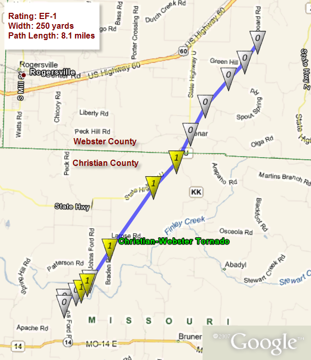
A broad band of thunderstorms began to move north out of Arkansas into southwest Missouri after 10:00 PM CST on 30 December. This band of storms initiated well ahead of the dry line and advancing cold front associated with a surface low located over northwest Missouri and eastern Kansas. Between 11:19 PM and 12:35 AM, these thunderstorms produced four tornadoes across Stone, Taney, Christian and Webster counties. The first tornado occured at 11:19 PM 3 SSE of Lampe, MO. This tornado caused minor damage to two homes and other minor damage, and had a path length of less than 1/4 of a mile and was rated an EF-1. At 11:26 PM, a supercell thunderstorm produced the second tornado, also rated EF-1, which touched down approximately 8 miles south of Branson West, MO in Stone County destroying boats and docks along the highway DD Peninsula on Table Rock Lake. Numerous homes experienced minor to moderate roof damage. This thunderstorm moved northeast into Christian County and produced another tornado. This tornado, rated EF-1, touched down approximately 3 miles northeast of Sparta, MO at 12:18 AM, with winds estimated around 105 mph and damage to numerous structures. Around the same time, a separate supercell thunderstorm produced an additional tornado, rated EF-0, that touched down at approximately 12:17 AM 2 miles SSW of Indian Point in Stone County. This storm touched down near the damage path of the tornado that occurred at 11:19 PM, damaging buildings, boats, and docks along the Indian Point Peninsula. Numerous severe thunderstorm warnings were issued for these thunderstorms as they moved to the northeast and evolved into bowing line segments. Between 1:00 and 2:00 AM CST, respectively, 0.75 to 1.00 inch hail was reported at numerous times in Webster, Laclede, and Pulaski counties. Wind gusts of 50 to 65 mph were also reported in Pulaski and Wright counties. Through the early morning hours this cluster of storms continued to lift north out of southwest Missouri and into central Missouri and Illinois.
2. Morning of the 31st
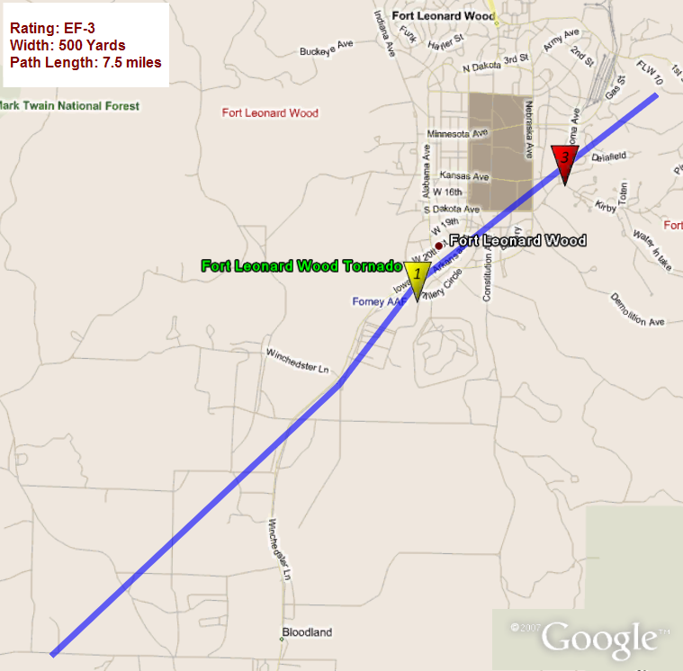
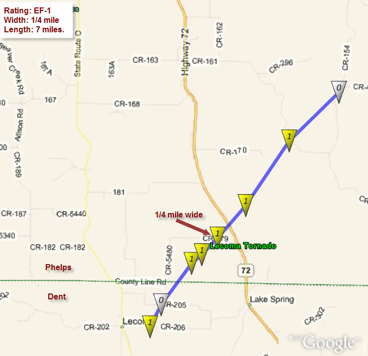
There was a lull in severe thunderstorm activity between approximately 2:30 and 8:00 AM CST across southwest Missouri as the previous thunderstorms continued to move north out of the region. Just before daybreak, a second line of thunderstorms across eastern Kansas began to push east into southwest Missouri. This line was oriented just ahead of the advancing cold front and dry line, which was located along a line from Kansas City to just east of Oklahoma City. This line moved slowly across southwest Missouri during the daylight hours of Friday morning, producing the most destructive severe weather of the day (five tornadoes and numerous reports of severe hail). At 7:52 AM, a tornado that originally touched down in northern Carrol County Arkansas crossed the border and was rated EF-0. The primary damage path was 2 miles north of Blue Eye, MO in Stone County, crossing the intersection of highways 86 and 13. As the line of thunderstorms continued to move northeast across the Ozarks it produced significant hail, with reports of golf ball to baseball size hail 7 miles north-northeast of Mansfield, MO in Wright County just after 9:00 AM. At 9:43 AM, a tornado rated EF-3 touched down at Fort Leonard Wood in Pulaski County. This tornado did significant damage to Fort Leonard Wood, with several homes destroyed and numerous structures damaged. This tornado had a path of 7.5 miles in length and was 500 yards at its widest point. After the Fort Leonard Wood tornado, a tornado associated with the same supercell was rated EF-3 and touched down northwest of Rolla, in Phelps County. This tornado destroyed two mobile homes and resulted in damage to numerous structures including the destruction of a two story house, leaving only its interior walls standing. This storm resulted in two fatalities in a single wide mobile home. The debris from this destroyed mobile home was thrown to the southwest against the movement of the tornado. The Rolla tornado had a path length of 11 miles and was 500 yards wide. The final, tornado was rated EF-1 and touched down at 10:12 AM 1 mile east of Lecoma, MO in Dent County. Three mobile homes were destroyed and resulted in two fatalities in one of these homes. This tornado had a path of less than 1 mile long and a width of 50 yards.
By 11:00 AM thunderstorms had almost completely moved out of southwest Missouri and into southeast and east central Missouri with continued convection across central and northwest Illinois. Severe thunderstorms and reports of tornadoes continued to occur with these storms as it progressed across the Mid-Mississippi Valley.
 |
 |
 |
 |
 |
 |
 |
 |
||
 |
 |
 |
 |

PRELIMINARY LOCAL STORM REPORT...SUMMARY
NATIONAL WEATHER SERVICE SPRINGFIELD MO
234 PM CST TUE JAN 04 2011

..TIME...   ...EVENT...      ...CITY LOCATION...     ...LAT.LON...
..DATE...   ....MAG....      ..COUNTY LOCATION..ST.. ...SOURCE....
            ..REMARKS..

1119 PM     TORNADO          3 SSE LAMPE             36.52N 93.42W
12/30/2010                   STONE              MO   EMERGENCY MNGR

            STONE COUNTY OFFICE OF EMERGENCY MANAGEMENT SURVEYED
            TORNADO DAMAGE APPROXIMATELY 2.5 MILES SOUTH SOUTHEAST OF
            LAMPE. MINOR DAMAGE CONSISTED OF ONE FRAME HOME...ONE
            MOBILE HOME...2 LARGE FARM GAS TANKS...AND AN
            OUTBUILDING.

1126 PM     TORNADO          8 S BRANSON WEST        36.58N 93.37W
12/30/2010                   STONE              MO   NWS STORM SURVEY

            NWS STORM SURVEY REVEALED THAT A STRONG EF-1 TORNADO
            IMPACTED THE EASTERN SHORE LINE OF THE HIGHWAY DD
            PENINSULA. NUMEROUS BOAT DOCKS AND BOATS WERE DESTROYED.
            APPROXIMATELY 60 HOMES EXPERIENCED MINOR TO MODERATE ROOF
            DAMAGE...WITH ONE WELL BUILT FRAME LOSING ITS ENTIRE
            ROOF. WIND SPEEDS WERE ESTIMATED AT 110 MPH.

1217 AM     TORNADO          2 SSW INDIAN POINT      36.61N 93.36W
12/31/2010                   STONE              MO   NWS STORM SURVEY

            AN EF-0 TORNADO TOUCHED DOWN ALONG THE INDIAN POINT
            PENINSULA EARLY FRIDAY MORNING. THE TORNADO DAMAGED
            SEVERAL BOATS...BOAT DOCKS...AND FRAME HOMES. THE PATH
            LENGTH OF THE TORNADO WAS 1.75 MILES...WITH A MAXIMUM
            WIDTH OF 75 YARDS. MAXIMUM WIND SPEEDS WERE ESTIMATED AT
            70 MPH. THIS WAS THE SECOND TORNADO TO OCCUR OVER THIS
            AREA.

1218 AM     TORNADO          3 NE SPARTA             37.03N 93.03W
12/31/2010  F1               CHRISTIAN          MO   NWS STORM SURVEY

            AN EF-1 TORNADO WITH A MAXIMUM WIDTH OF 250 YARDS AND
            WIND SPEEDS ESTIMATED NEAR 105 MPH CAUSED MAJOR DAMAGE TO
            SEVERAL STRUCTURES. ONE TRAILER HOME WAS SPUN AND
            DISPLACED 150 YARDS. A LARGE BARN HAD ITS ROOF REMOVED
            WITH SEVERAL COLLAPSED WALLS. NUMEROUS TREES WERE
            UPROOTED WITH MANY OUTBUILDINGS DESTROYED.

1235 AM     TSTM WND DMG     BRANSON WEST            36.70N 93.37W
12/31/2010                   STONE              MO   TRAINED SPOTTER

            REPORT FROM TRAINED SPOTTER VIA MEDIA OF POWER FLASHES
            AROUND BRANSON WEST.

1255 AM     HAIL             NIANGUA                 37.39N 92.83W
12/31/2010  M0.75 INCH       WEBSTER            MO   PUBLIC

            WIND GUSTS ESTIMATED TO 40 MPH AS WELL

0110 AM     LIGHTNING        1 N LEBANON             37.69N 92.66W
12/31/2010                   LACLEDE            MO   EMERGENCY MNGR

            LIGHTNING STRUCK A LARGE TWO STORY HOME JUST NORTH OF
            LEBANON. THE RESULTANT FIRE BURNED DOWN THE HOME.

0120 AM     HAIL             3 E FORDLAND            37.16N 92.89W
12/31/2010  E0.50 INCH       WEBSTER            MO   AMATEUR RADIO

            DIME SIZED HAIL

0131 AM     HAIL             DRY KNOB                37.64N 92.45W
12/31/2010  E1.00 INCH       LACLEDE            MO   BROADCAST MEDIA

0136 AM     TSTM WND GST     RICHLAND                37.86N 92.40W
12/31/2010  E60.00 MPH       PULASKI            MO   EMERGENCY MNGR

            RELAYED FROM LACLEDE COUNTY EM OFFICE

0148 AM     TSTM WND GST     GROVESPRING             37.40N 92.61W
12/31/2010  E50.00 MPH       WRIGHT             MO   PUBLIC

            PEA HAIL REPORTED AS WELL

0204 AM     HAIL             DIXON                   37.99N 92.09W
12/31/2010  E1.00 INCH       PULASKI            MO   PUBLIC

0204 AM     TSTM WND GST     DIXON                   37.99N 92.09W
12/31/2010  M65.00 MPH       PULASKI            MO   PUBLIC

0752 AM     TORNADO          2 N BLUE EYE            36.52N 93.40W
12/31/2010  F0               STONE              MO   NWS STORM SURVEY

            AN EF-0 TORNADO TOUCHED DOWN JUST SW OF THE INTERSECTION
            OF HWYS 86 AND 13 N OF BLUE EYE. THIS TORNADO CAUSED TREE
            DAMAGE AND DAMAGE TO A CAR PORT. THE PATH LENGTH OF THE
            TORNADO WAS 0.25 MILES...WITH A MAXIMUM WIDTH OF 50
            YARDS. THE MAXIMUM WINDS WERE ESTIMATED TO BE 65 MPH.
            THIS WAS THE THIRD TORNADO TO OCCUR IN STONE COUNTY
            DURING THE EVENT.

0755 AM     HAIL             2 N NIXA                37.07N 93.29W
12/31/2010  M1.00 INCH       CHRISTIAN          MO   AMATEUR RADIO

0807 AM     HAIL             2 S TURNERS             37.15N 93.16W
12/31/2010  M1.00 INCH       GREENE             MO   EMERGENCY MNGR

0837 AM     TORNADO          5 NE BOLIVAR            37.67N 93.35W
12/31/2010  F0               POLK               MO   NWS STORM SURVEY

            BASED UPON INITIAL REPORTS FROM THE POLK COUNTY EMERGENCY
            MANAGEMENT AGENCY...AN NWS STORM SURVEY DETERMINED AN EF0
            TORNADO CAUSED MINOR DAMAGE TO THREE
            STRUCTURES...INCLUDING TEARING A SECTION OF A ROOF OFF
            ONE HOME. THE TORNADO INITIALLY TOUCHED DOWN AT 837 AM
            NEAR THE INTERSECTION OF 155 AND 430TH...5 MILES
            NORTHEAST OF BOLIVAR AND LIFTED A MINUTE LATER NEAR THE
            INTERSECTION OF 170 AND 420TH...OR ABOUT 6 MILES
            NORTHEAST OF BOLIVAR.

0842 AM     HAIL             4 E MARSHFIELD          37.34N 92.83W
12/31/2010  E0.88 INCH       WEBSTER            MO   AMATEUR RADIO

            WINDS ESTIMATED AT 50 MPH.

0905 AM     HAIL             MANSFIELD               37.11N 92.58W
12/31/2010  E1.00 INCH       WRIGHT             MO   AMATEUR RADIO

0905 AM     HAIL             7 NNE MANSFIELD         37.20N 92.53W
12/31/2010  E2.75 INCH       WRIGHT             MO   AMATEUR RADIO

            GOLF BALL TO BASEBALL SIZED HAIL REPORTED

0910 AM     HAIL             MANSFIELD               37.11N 92.58W
12/31/2010  E1.25 INCH       WRIGHT             MO   AMATEUR RADIO

0910 AM     HAIL             MANSFIELD               37.11N 92.58W
12/31/2010  E1.25 INCH       WRIGHT             MO   LAW ENFORCEMENT

0925 AM     TSTM WND DMG     5 N DAWSON              37.33N 92.31W
12/31/2010                   WRIGHT             MO   AMATEUR RADIO

            STRUCTURE DAMAGE 5 MILES NORTH OF DAWSON.

0943 AM     TORNADO          4 NE FORT LEONARD WOOD  37.75N 92.11W
12/31/2010  F3               PULASKI            MO   NWS STORM SURVEY

            A NATIONAL WEATHER SERVICE STORM SURVEY TEAM DETERMINED
            THAT EF-3 TORNADO INITIALLY TOUCHED DOWN 1 MILE SOUTHWEST
            OF THE FT WOOD AIRPORT THEN DAMAGED OR DESTROYED NUMEROUS
            HOMES AND DAMAGED DOZENS OF OTHER BUILDINGS. THE TORNADO
            PATH LENGTH WAS 5 MILES...WITH A MAXIMUM WIDTH OF 500
            YARDS.

1006 AM     TORNADO          2 WSW ROLLA             37.94N 91.80W
12/31/2010  F3               PHELPS             MO   NWS STORM SURVEY

            *** 2 FATAL *** A NATIONAL WEATHER SERVICE STORM SURVEY
            DETERMINED THAT AN EF-3 TORNADO OCCURRED NORTH OF ROLLA
            MISSOURI. MAXIMUM PATH WIDTH WAS 500 YARDS. DAMAGE PATH
            LENGTH WAS 11 MILES. TWO FATALITIES OCCURRED WHEN A
            SINGLE WIDE MOBILE HOME WAS COMPLETELY DESTROYED WITH THE
            DEBRIS THROWN AGAINST THE MOVEMENT OF THE TORNADO.
            SEVERAL OTHER MOBILE HOMES AND FRAME HOMES SUFFERED
            SIGNIFICANT DAMAGE...INCLUDING A TWO STORY BRICK HOME
            WHERE A CAR WAS THROWN OVER THE HOME.

1012 AM     TORNADO          1 E LECOMA              37.78N 91.72W
12/31/2010  F1               DENT               MO   NWS STORM SURVEY

            *** 2 FATAL *** LAW ENFORCEMENT REPORTS 3 MOBILE HOMES
            DESTROYED AND EXTENSIVE DAMAGE TO NUMEROUS STRUCTURES
            ALONG COUNTY ROAD 2050. A NATIONAL WEAHER SERVICE STORM
            SURVEY TEAM DETERMINED THAT THE DAMAGE WAS CAUSED BY AN
            EF-1 TORNADO WITH A WIDTH OF 50 YARDS. THE PATH OF THE
            TORNADO WAS LESS THAN ONE MILE LONG. TWO CONFIRMED
            FATALITIES OCCURRED.
Several tornado damage surveys were conducted by the National Weather Service in Springfield, MO on December 31st, January 1st, and January 2nd. Teams were sent to Fort Leonard Wood, Rolla, Northeastern Christian County, Polk County, Lecoma, and Table Rock Lake.
Rating: EF-3
Width: 500 yards
Path Length: 7.5 miles
AT 943 AM ON DECEMBER 31ST...A NATIONAL WEATHER SERVICE STORM SURVEY
TEAM HAS DETERMINED THAT AN EF-3 TORNADO OCCURRED OVER FORT LEONARD
WOOD MISSOURI. THE MAXIMUM WIDTH OF THE TORNADO WAS 500 YARDS.
THE DAMAGE PATH WAS APPROXIMATELY 7.5 MILES LONG AND WAS CONFINED
TO THE INTERIOR OF THE BASE.
NUMEROUS HOMES WERE DESTROYED ON THE EAST SIDE OF THE BASE. SEVERAL
HOMES SUFFERED COMPLETE WALL DAMAGE. THE WATER TREATMENT PLANT ON THE
BASE WAS SEVERELY DAMAGED...LOOSING ITS SECOND STORY.
 |
Rating: EF-3
Width: 500 yards
Path Length: 11 miles
AT 1006 AM...A NATIONAL WEATHER SERVICE SURVEY TEAM DETERMINED THAT AN EF-3
TORNADO OCCURRED NORTH OF ROLLA MISSOURI ON DECEMBER 31ST 2010.
THE DAMAGE PATH FROM THIS TORNADO WAS APPROXIMATELY 11 MILES
LONG...RUNNING FROM JUST NORTH OF INTERSTATE 44 ONE MILE WEST OF
ROLLA TO HIGHWAY 68 THREE MILES NORTHWEST OF INTERSTATE 44. THE
MAXIMUM WIDTH OF THE TORNADO WAS 500 YARDS.
THE HEAVIEST DAMAGED OCCURRED BETWEEN STATE HIGHWAY E AND COUNTY
ROAD 8040. TWO SINGLE WIDE MOBILE HOMES WERE COMPLETELY DESTROYED
WITH DEBRIS THROWN UPSTREAM WHILE THE FRAMES WERE DETACHED. TWO
FATALITIES OCCURRED IN ONE OF THESE HOMES. A TWO STORY HOME HAD ALL
BUT ITS INTERIOR WALLS DESTROYED. SEVERAL CARS WERE THROWN...WITH ONE
VEHICLE THROWN OVER THE DESTROYED HOME.
IN ADDITION...MINOR TO MODERATE ROOF AND TREE DAMAGE OCCURRED AT
VARIOUS LOCATIONS NEAR THE STARTING POINT TO HIGHWAY 63 NORTH OF
ROLLA. PRIMARILY TREE DAMAGE OCCURRED BETWEEN HIGHWAY 63 AND
HIGHWAY 68.
Rating: EF-1
Width: 1/4 mile wide
Path Length: 7 miles
AT 1012 AM...The National Weather Service Survey Team determined that an EF-1 Tornado occurred near the town of Lecoma on December 31st, 2010. The tornado was estimated to be 50 yards wide along county road 2050 near Lecoma with estimated winds of 90 to 100 mph. The tornado continued for approximately 7 miles into rural Phelps county where it enlarged to around a quarter mile wide near county road 179. The tornado ended around county road 154 as an EF-0 about 50 yards wide.
Several structures were destroyed along its path including a mobile home near Lecoma where 2 fatalities occurred.
 |
Rating: EF-1
Width: 250 yards
Path Length: 8.1 miles
AT 1218 AM ON DECEMBER 31ST...A NATIONAL WEATHER SERVICE STORM SURVEY TEAM
CONFIRMED THAT DAMAGE THAT OCCURRED ACROSS NORTHEASTERN CHRISTIAN COUNTY
AND SOUTHWESTERN WEBSTER COUNTY WAS DUE TO AN EF-1 TORNADO.
THE WIDTH OF THE TORNADO VARIED FROM AS NARROW AS 50 YARDS TO A
MAXIMUM WIDTH OF AROUND 250 YARDS. ESTIMATED WINDS SPEEDS WITH
THIS TORNADO RANGED FROM 80 MILES PER HOUR TO NEAR 105 MILES PER
HOUR.
ONE TRAILER HOME WAS SPUN 180 DEGREES AND DISPLACED 150 YARDS. TWO
INDIVIDUALS TOOK SHELTER IN A BATHTUB WITHIN THE STRUCTURE...BOTH
SURVIVING THE STORM UNINJURED. A LARGE BARN WAS SEVERELY
DAMAGED...LOSING ITS ROOF WITH SEVERAL COLLAPSED WALLS. NUMEROUS
TREES WERE SNAPPED...UPROOTED...AND BLOWN ACROSS ROADWAYS ALONG
THE DAMAGE PATH. NUMEROUS OUTBUILDINGS WERE ALSO DAMAGED AND
DESTROYED.
A NATIONAL WEATHER SERVICE STORM SURVEY...IN COOPERATION WITH THE
MISSOURI WATER PATROL AND STONE COUNTY OFFICE OF EMERGENCY
MANAGEMENT...REVEALED THAT THREE SEPARATE TORNADOES OCCURRED NEAR
THE TABLE ROCK LAKE AREA LATE DECEMBER 30TH AND EARLY MORNING
DECEMBER 31ST.
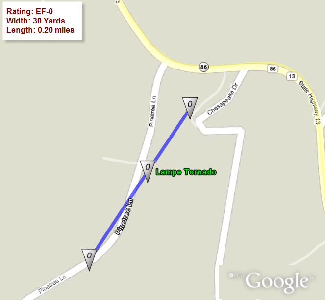
TORNADO NUMBER 1:
AT 1119 PM ON THE 30TH OF DECEMBER...THE STONE COUNTY OFFICE OF
EMERGENCY MANAGEMENT CONFIRMED THAT AN EF-0 TORNADO TOUCHED
DOWN IN A RURAL AREA 2.5 MILES SOUTHEAST OF LAMPE.
THE TORNADO CAUSED MINOR DAMAGED TO A MOBILE HOME...STOCK
TRAILER...TWO LARGE FARM GAS TANKS...A FRAMED HOME...AND AN
OUTBUILDING.
PATH LENGTH...0.20 MILES.
PATH WIDTH...30 YARDS.
MAX WIND SPEEDS...65 MPH.
RATING...EF-0.
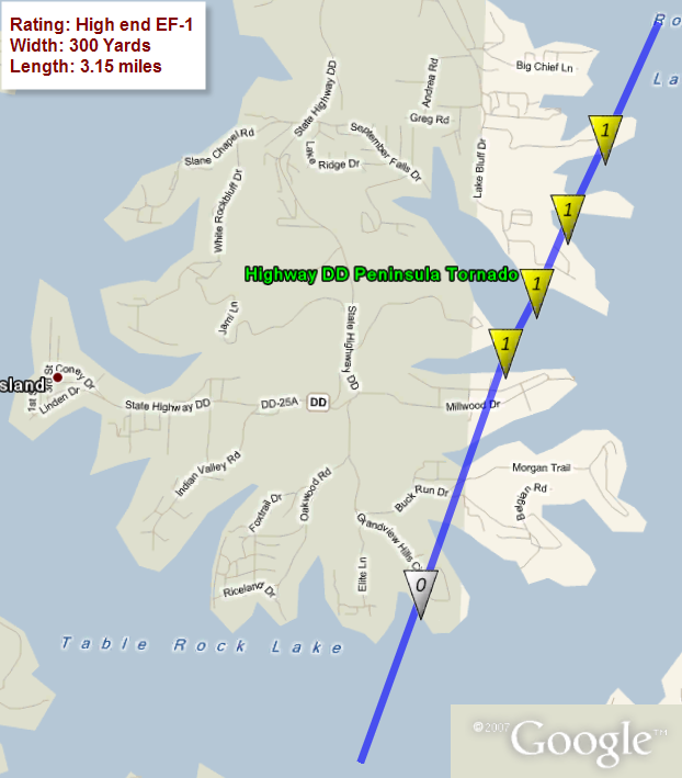
TORNADO NUMBER 2:
AT 1126 PM DECEMBER 30TH...A STRONG EF-1 TORNADO TOUCHED DOWN ON
THE MAIN CHANNEL OF TABLE ROCK LAKE JUST NORTHEAST OF THE COW
CREEK RECREATIONAL AREA. THE TORNADO THEN IMPACTED THE EASTERN
EDGE OF THE HIGHWAY DD PENINSULA. THIS TORNADO CROSSED SIX
DIFFERENT COVES...DAMAGING OR DESTROYING 11 BOAT DOCKS.
APPROXIMATELY 25 BOATS WERE EITHER DESTROYED OR DAMAGED.
THIS TORNADO ALSO DAMAGED APPROXIMATELY 60 FRAME HOMES...WITH MOST
OF THE HOUSES EXPERIENCING MINOR TO MODERATE ROOF DAMAGE. ONE WELL
BUILT BRICK HOME HAD ITS ENTIRE ROOF TAKEN OFF ITS STRUCTURE. THIS
HOME WAS LOCATED IN THE TRAILS END COMMUNITY. THE TORNADO THEN
IMPACTED TWO MORE COVES PRIOR TO MOVING BACK OVER THE OPEN WATERS OF
TABLE ROCK LAKE. THE TORNADO DISSIPATED PRIOR TO REACHING THE
WESTERN SHORE LINE OF THE INDIAN POINT PENINSULA.
DAMAGE PATH LENGTH WAS 3.15 MILES.
MAXIMUM DAMAGE WIDTH WAS 300 YARDS.
MAXIMUM WINDS WERE ESTIMATED AT 110 MPH.
RATING...HIGH END EF-1.
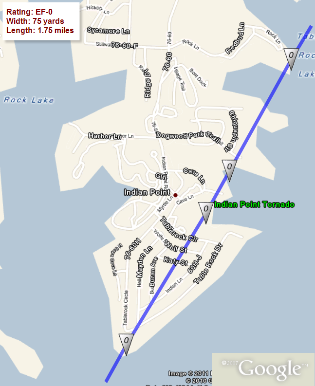
TORNADO NUMBER 3:
AT 1217 AM DECEMBER 31ST...AN EF-0 TORNADO TOUCHED DOWN ALONG THE
SOUTHERN POINT OF THE INDIAN POINT PENINSULA. THE TORNADO IMPACTED
A NEIGHBORHOOD WITH FRAME HOMES PRIOR TO DAMAGING THE EASTERN
SHORE LINE OF THE PENINSULA. FOUR COVES WERE AFFECTED BY THIS
TORNADO DAMAGING APPROXIMATELY 6 BOAT DOCKS. THESE BOAT DOCKS HAD
MAINLY OPEN SLIPS...WITH APPROXIMATELY FOUR BOATS DAMAGED.
THE TORNADO DAMAGED ONE BOAT DOCK AT ROCK LANE RESORT...AND THEN
MOVED OVER OPEN WATER WHERE IT DISSIPATED PRIOR TO REACHING THE
COMPTON RIDGE SHORE LINE.
DAMAGE PATH LENGTH WAS 1.75 MILES.
MAXIMUM DAMAGE WIDTH WAS 75 YARDS.
MAXIMUM WINDS WERE ESTIMATED AT 70 MPH.
RATING...EF-0.
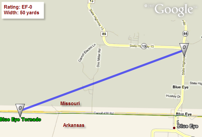
TORNADO NUMBER 4:
AT 752 AM DECEMBER 31ST...AN EF-0 TORNADO TOUCHED DOWN IN CARROL
COUNTY ARKANSAS...MOVED INTO MISSOURI...AND CAUSED DAMAGE NEAR AN
OPEN FIELD SOUTHWEST OF THE INTERSECTION OF HIGHWAY 86 AND HIGHWAY 13
NORTH OF BLUE EYE. THE TORNADO KNOCKED DOWN SEVERAL TREES WHILE
DESTROYING A CAR PORT AT A RESIDENCE. THE TORNADO LIFTED AS IT WAS
CROSSING HIGHWAY 13.
MAXIMUM DAMAGE WIDTH WAS 50 YARDS.
MAXIMUM WINDS WERE ESTIMATED AT 65 MPH.
RATING...EF-0.
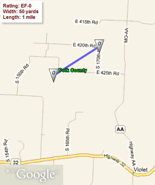
Rating: EF-0
Width: 50 yards
Path Length: 1 mile
A NATIONAL WEATHER SERVICE SURVEY TEAM DETERMINED THAT AN EF-0 TORNADO
BRIEFLY TOUCHED DOWN TO THE NORTHEAST OF BOLIVAR IN POLK COUNTY ON DECEMBER
31ST 2010.
THE TORNADO TOUCHED DOWN AT 837 AM...AND CAUSED AN INTERMITTENT
DAMAGE PATH THAT WAS APPROXIMATELY 1 MILE IN LENGTH. THE PATH
EXTENDED FROM NEAR THE INTERSECTION OF COUNTY ROADS 155 AND
430...OR ABOUT 5 MILES NORTHEAST OF BOLIVAR TO NEAR THE
INTERSECTION OF COUNTY ROADS 170 AND 420...OR 6 MILES NORTHEAST OF
BOLIVAR. THE MAXIMUM WIDTH OF THE TORNADO WAS 50 YARDS.
THE DAMAGE FROM THIS TORNADO WAS SPARSE DUE TO ITS WEAK INTENSITY
AND THAT IT TRACKED MAINLY ACROSS OPEN FIELDS. THREE STRUCTURES
SUFFERED MINOR DAMAGE...INCLUDING A PORTION OF A ROOF REMOVED FROM ONE
HOME.
THERE WERE NO INJURIES.


 Weather Story
 Weather Map
 Local Radar