Springfield, MO
Weather Forecast Office
A line of strong to severe thunderstorms developed and pushed across southeast Kansas and southwest Missouri during the afternoon and evening hours of May 13, 2009. Thunderstorms rapidly developed and became severe as a slow moving cold front interacted with a warm, moist, and very unstable atmosphere Wednesday afternoon. Storms initially took on both supercell and line segment characteristics with large hail, damaging winds, and heavy rainfall. As slightly stonger vertical wind shear worked its way into the thunderstorm environment, a few of these storms began to exhibit strong rotation and a few reports of tornadoes were received (See Storm Reports Below). The storms eventually merged into a solid line of thunderstorms with damaging wind and large hail being the primary threats, and eventually moved off into Arkansas and southeast Missouri. NWS Storm survey crews are assessing the damage today.
Storm Survey Results
...Tornado in Bourbon County Kansas...
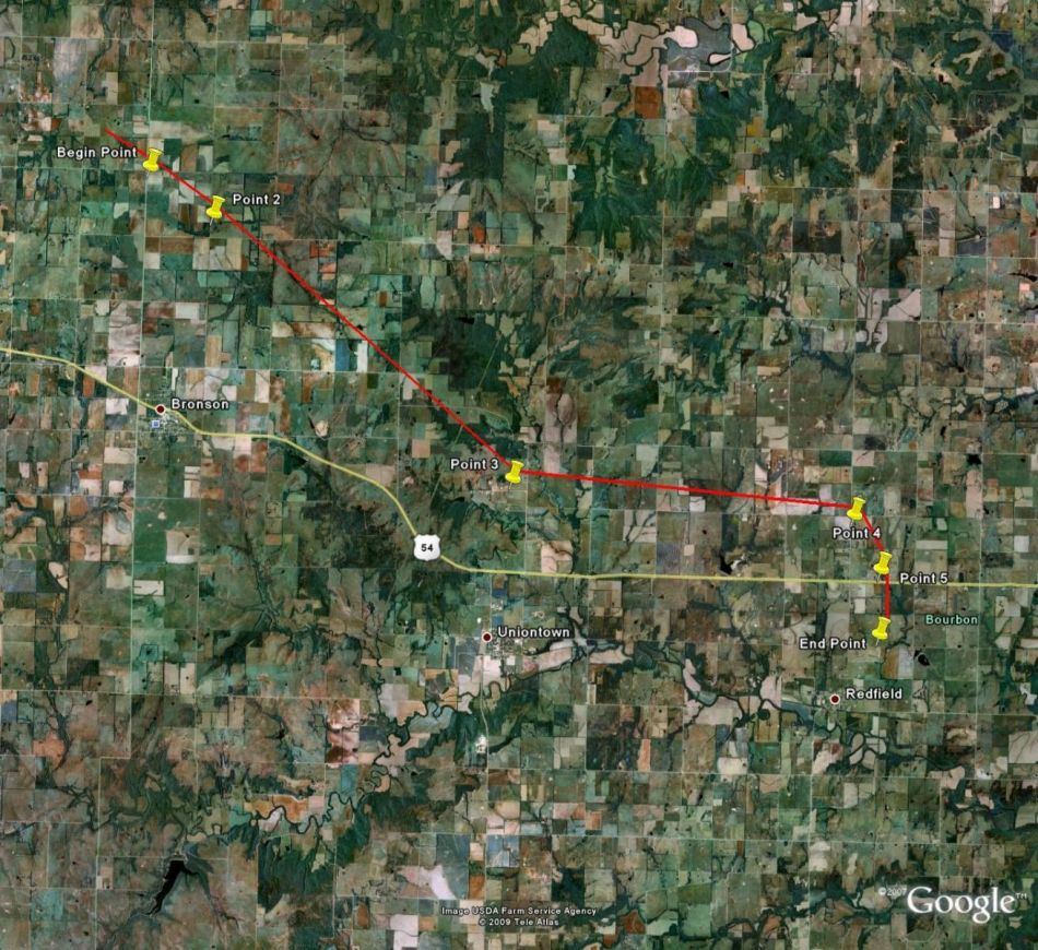
A NWS STORM SURVEY HAS FOUND AN INTERMITTENT TORNADO DAMAGE PATH FROM NORTHEAST ALLEN COUNTY EXTENDING INTO BOURBON COUNTY. THE EF 1TORNADO DAMAGED 5 LARGE HAY BARNS...OUTBUILDINGS AND UPROOTED NUMEROUS TREES. WIND SPEED IS ESTIMATED AT 90 MPH WITH A PATH WIDTH OF 300 YARDS AND AN INTERMITTENT PATH LENGTH OF 8 MILES.
... MICROBURST DAMAGE CONFIRMED NEAR PURDY IN BARRY COUNTY ...
A NATIONAL WEATHER SERVICE STORM SURVEY TEAM DETERMINED THAT A
MICROBURST OCCURRED NEAR THE TOWN OF PURDY IN BARRY COUNTY. THE
MICROBURST OCCURRED AT APPROXIMATELY 1120 PM ON WEDNESDAY AND
PRODUCED DAMAGING WINDS OF 80 TO 85 MPH. THE WINDS TIPPED AND
DESTROYED A TRAILER HOME...INJURING ONE PERSON. OTHER DAMAGE
INCLUDED ROOF DAMAGE TO A NEARBY RESIDENCE...A DESTROYED
CARPORT...AND SEVERAL UPROOTED TREES.

Current Hazards
Experimental Graphical Hazardous Weather Outlook
Submit a storm report
Local Storm Reports
Current Conditions
Observations
Lake Levels
Snowfall Analysis
Road Conditions
Satellite
CoCoRaHS
Graphical Conditions
Precip. Analysis
Forecasts
Forecast Discussion
Fire Weather
Aviation
GIS Forecast Maps
Activity Planner
Severe Weather
Winter Weather
Hurricanes
FAA Center Weather
Space Weather
Climatology
Records and Normals
Monthly Climate Summary
Local
National
Drought
Climate Science
Astronomical Data
US Dept of Commerce
National Oceanic and Atmospheric Administration
National Weather Service
Springfield, MO
Springfield-Branson National Airport
5805 West Highway EE
Springfield, MO 65802-8430
Business: 417-863-8028 Recording: 417-869-4491
Comments? Questions? Please Contact Us.


 Weather Story
 Weather Map
 Local Radar