A broken line of severe thunderstorms made its way across southeast Kansas and much of Missouri early on the morning of Sunday, March 8. A stationary front extended from south central Kansas through northern Missouri for much of the overnight hours with scattered thunderstorms along the front for an extended amount of time. By 4 AM, an area of low pressure began to rapidly strengthen and move northeast along the front. At the same time, a vigorous band of upper level jet stream winds interacted with this low pressure, causing the thunderstorms to intensify across the region.
As the low pressure continued off to the northeast, it began to pull the frontal boundary through the Ozarks region. A broken line of thunderstorms developed along the entire front around sunrise, and rapidly moved east. Stronger storms embedded within the line exhibited signs of rotation, and produced scattered wind damage through much of the Ozarks, as well as isolated reports of large hail. Much of the wind damage was reported as downed limbs and trees, although some locations did report structural damage, particularly to outbuildings and roofs. National Weather Service teams are surveying the damage reports, and updated information will be provided as it becomes available. The line of storms moved quickly to the east, continuing to produce severe weather across eastern Missouri, Illinois, and Indiana through the day on Sunday.

Close up view of the areas of concentrated damage in Bourbon county Kansas.

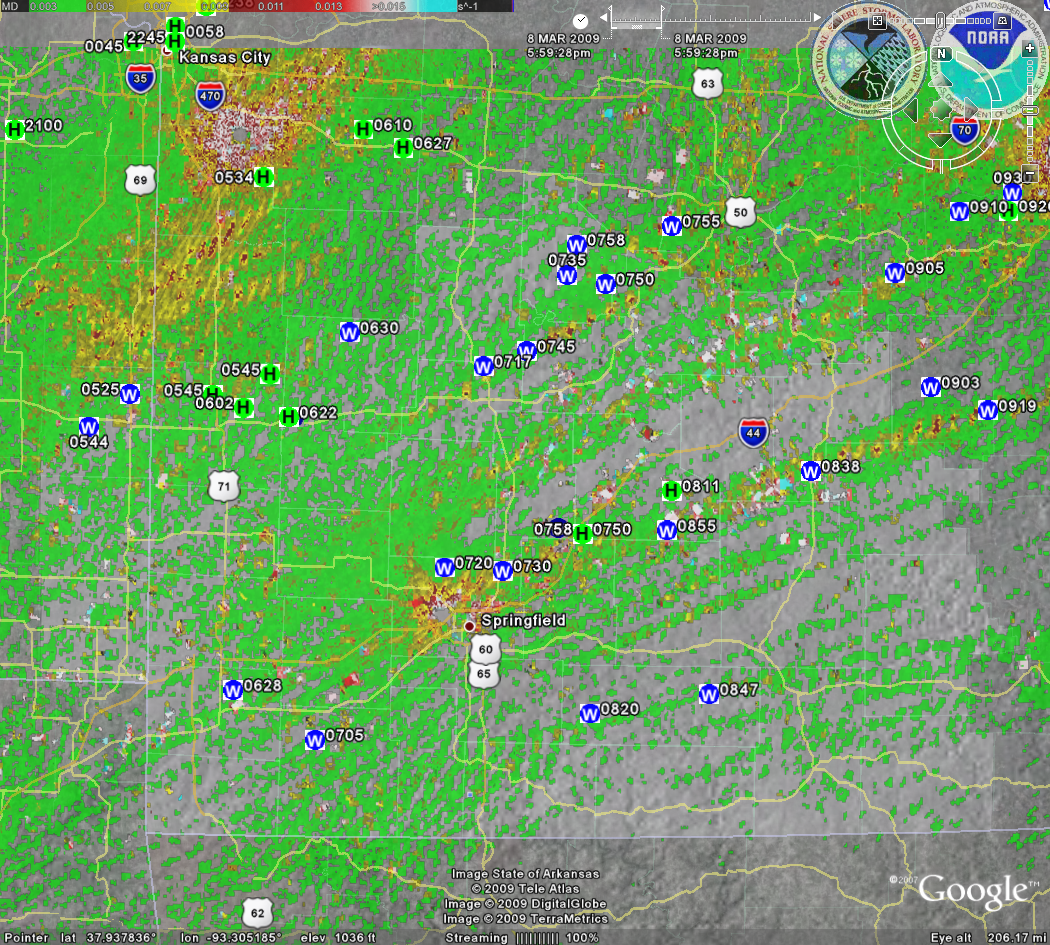
The image below is of the doppler radar indicated areas of rotation within the storms as they moved across the area Sunday morning. Notice that many of the severe weather reports occur near or within the areas of strongest rotation (red and yellow areas). Rotation within a storm does not always mean that a tornado is present. However, thunderstorm rotation increases the strength of the storm, and is often a precursor to severe weather occurrence.
NOTE: The red and white areas near the radar locations at Springfield, Kansas City, and St. Louis are a result of algorithm errors in close proximity to the radar location.
.TIME... ...EVENT... ...CITY LOCATION... ...LAT.LON...
..DATE... ....MAG.... ..COUNTY LOCATION..ST.. ...SOURCE....
..REMARKS..
0625 AM TSTM WND DMG 1 NW HAMMOND 37.95N 94.71W
03/08/2009 BOURBON KS LAW ENFORCEMENT
ONE HOME AND NUMEROUS TREES DAMAGED. POSSIBLE TORNADO
TOUCH DOWN.
0640 AM TSTM WND DMG 4 SE DEVON 37.88N 94.77W
03/08/2009 BOURBON KS EMERGENCY MNGR
NEAR HIGHWAY 69 AND 235TH STREET HOME DAMAGED. POSSIBLE
INJURIES.
0640 AM HAIL DEVON 37.92N 94.82W
03/08/2009 E0.70 INCH BOURBON KS EMERGENCY MNGR
0644 AM TSTM WND DMG REDFIELD 37.84N 94.88W
03/08/2009 BOURBON KS EMERGENCY MNGR
NEAR 1370 JAYHAWK RD. TRAILER HAME AND METAL OUT BUILDING
DAMAGED.
0644 AM TSTM WND DMG 5 N FORT SCOTT 37.91N 94.71W
03/08/2009 BOURBON KS EMERGENCY MNGR
TREES DOWN AND VACANT HOME DAMAGED ALONG A PATH FROM 150
AND JAYHAWK ROAD TO 120 AND INDIAN ROAD.
0645 AM HAIL SCHELL CITY 38.02N 94.12W
03/08/2009 E0.88 INCH VERNON MO EMERGENCY MNGR
0645 AM HAIL 2 S HORTON 37.95N 94.36W
03/08/2009 E0.88 INCH VERNON MO CO-OP OBSERVER
0702 AM HAIL 1 N WALKER 37.91N 94.23W
03/08/2009 E1.00 INCH VERNON MO LAW ENFORCEMENT
0703 AM HAIL 3 W HARWOOD 37.96N 94.21W
03/08/2009 E0.70 INCH VERNON MO LAW ENFORCEMENT
0722 AM HAIL 1 W EL DORADO SPRINGS 37.88N 94.04W
03/08/2009 E1.00 INCH CEDAR MO PUBLIC
0722 AM TSTM WND GST 1 W EL DORADO SPRINGS 37.88N 94.04W
03/08/2009 E40.00 MPH CEDAR MO PUBLIC
0728 AM TSTM WND GST 4 N GRANBY 36.98N 94.25W
03/08/2009 E60.00 MPH NEWTON MO CO-OP OBSERVER
0729 AM TSTM WND GST EL DORADO SPRINGS 37.88N 94.02W
03/08/2009 E60.00 MPH CEDAR MO EMERGENCY MNGR
0729 AM HAIL EL DORADO SPRINGS 37.88N 94.02W
03/08/2009 E0.70 INCH CEDAR MO EMERGENCY MNGR
0730 AM TSTM WND DMG 4 WNW LOWRY CITY 38.16N 93.79W
03/08/2009 ST. CLAIR MO LAW ENFORCEMENT
TREES BLOWN DOWN ON HIGHWAY A 4 MILES WEST OF HIGHWAY 13.
0802 AM TSTM WND GST COLE CAMP 38.46N 93.20W
03/08/2009 E50.00 MPH BENTON MO TRAINED SPOTTER
0805 AM TSTM WND GST PURDY 36.82N 93.92W
03/08/2009 E60.00 MPH BARRY MO EMERGENCY MNGR
0816 AM TSTM WND GST 1 N WILLARD 37.32N 93.43W
03/08/2009 E64.00 MPH GREENE MO TRAINED SPOTTER
0817 AM TSTM WND GST 2 N CROSS TIMBERS 38.05N 93.23W
03/08/2009 M68.00 MPH HICKORY MO NWS STORM SURVEY
NUMEROUS TREES DOWN AND TOPS OFF SOME TREES. OFFICIAL NWS
STORM SURVEY INDICATED DAMAGE WAS A RESULT OF SEVERE
STRAIGHT LINE WINDS.
0820 AM TSTM WND GST 6 NNE WILLARD 37.39N 93.39W
03/08/2009 E65.00 MPH GREENE MO NWS EMPLOYEE
SEVERAL TREE LIMBS DOWN. SIDING AND ROOF DEBRIS BLOWN
INTO YARD FROM NEIGHBORS OUTBUILDING. WINDS ESTIMATED 60
TO 65 MPH.
0821 AM TSTM WND DMG 2 SE OLIVE 37.44N 93.08W
03/08/2009 DALLAS MO EMERGENCY MNGR
TRAMPOLINE WRAPPED AROUND POWERLINE.
0827 AM TSTM WND DMG 5 E CHARITY 37.52N 92.92W
03/08/2009 DALLAS MO EMERGENCY MNGR
BARN BLOWN DOWN.
0830 AM TSTM WND DMG FAIR GROVE 37.38N 93.15W
03/08/2009 GREENE MO NWS STORM SURVEY
THE UPPER ELEMENTARY SCHOOL ROOF WAS PEALED OFF. OFFICIAL
NWS STORM SURVEY REVEALED THAT THIS DAMAGE WAS THE RESULT
OF STRAIGHT LINE WINDS ESTIMATED AT 85 MPH.
0835 AM TSTM WND GST 4 NW GRAVOIS MILLS 38.35N 92.88W
03/08/2009 E65.00 MPH MORGAN MO TRAINED SPOTTER
0845 AM TSTM WND GST 3 WNW BRANCH 37.93N 93.05W
03/08/2009 E50.00 MPH CAMDEN MO TRAINED SPOTTER
0845 AM TSTM WND DMG CLIMAX SPRINGS 38.10N 93.05W
03/08/2009 CAMDEN MO NWS STORM SURVEY
ROOF TORN OFF OF BOAT STORAGE COMPANY WITH HIGH WINDS
REPORTED. OFFICIAL NWS STORM SURVEY INDICATED DAMAGE WAS
DUE TO STRAIGHT LINE WINDS ESTIMATED AT 70 MPH.
0850 AM TSTM WND GST CONWAY 37.50N 92.82W
03/08/2009 E55.00 MPH LACLEDE MO TRAINED SPOTTER
0850 AM TSTM WND DMG 3 N ROCKY MOUNT 38.32N 92.72W
03/08/2009 MORGAN MO EMERGENCY MNGR
BARN BLOWN OVER ONTO HIGHWAY W.
0850 AM HAIL CONWAY 37.50N 92.82W
03/08/2009 E1.00 INCH LACLEDE MO TRAINED SPOTTER
0858 AM TSTM WND DMG 1 N VERSAILLES 38.45N 92.84W
03/08/2009 MORGAN MO EMERGENCY MNGR
SEVERAL MINI BARNS BLOWN ONTO HIGHWAY W NORTH OF TOWN.
0858 AM TSTM WND DMG CONWAY 37.50N 92.82W
03/08/2009 LACLEDE MO NWS STORM SURVEY
BUILDING AND TREE DAMAGE REPORTED IN TOWN. OFFICIAL NWS
STORM SURVEY INDICATED THAT THIS DAMAGE WAS THE RESULT OF
STRAIGHT LINE WINDS ESTIMATED AT UP TO 70 MPH.
0911 AM HAIL DRY KNOB 37.64N 92.45W
03/08/2009 E0.75 INCH LACLEDE MO EMERGENCY MNGR
0920 AM TSTM WND DMG 1 E GOODHOPE 36.91N 92.79W
03/08/2009 DOUGLAS MO LAW ENFORCEMENT
BARN DAMAGE.
0924 AM TSTM WND DMG 3 NW COMPETITION 37.51N 92.47W
03/08/2009 LACLEDE MO AMATEUR RADIO
HOME DAMAGED AT HIGHWAY O AND ROAD 181.
0938 AM TSTM WND DMG EDGAR SPRINGS 37.70N 91.87W
03/08/2009 PHELPS MO PUBLIC
SIGNIFICANT DAMAGE TO GARAGE...TREES...AND FENCES.
NUMEROUS ROOFS DAMAGED WITH WINDOWS BLOWN OUT OF
BUILDINGS.
0947 AM TSTM WND DMG VANZANT 36.97N 92.30W
03/08/2009 DOUGLAS MO LAW ENFORCEMENT
TREES DOWN.
1253 PM NON-TSTM WND GST VICHY 38.11N 91.76W
03/08/2009 M55.00 MPH MARIES MO ASOS


 Weather Story
 Weather Map
 Local Radar