 |
Tornadoes - May 10th, 2008National Weather Service, Springfield, MO |
 |
Early in the day of May 10, 2008, a vigorous storm system moved across the Plains. Surface low pressure developed over south central Kansas in advance of an upper level wave of low pressure, and substantial jet stream. A dryline extended south from the low pressure through central Oklahoma and north central Texas while a warm front extended through Arkansas and east into portions of Mississippi. As the day progressed and the surface low pressure strengthened, elevated thunderstorms developed over northeast Oklahoma and southwest Missouri. These storms produced penny size hail as they progressed northeast. This batch of thunderstorms developed in an area of abundant wind shear, but they were unable to develop any 'near-surface' rotation due to a stable airmass throughout the lowest 2 kilometers of the atmosphere.
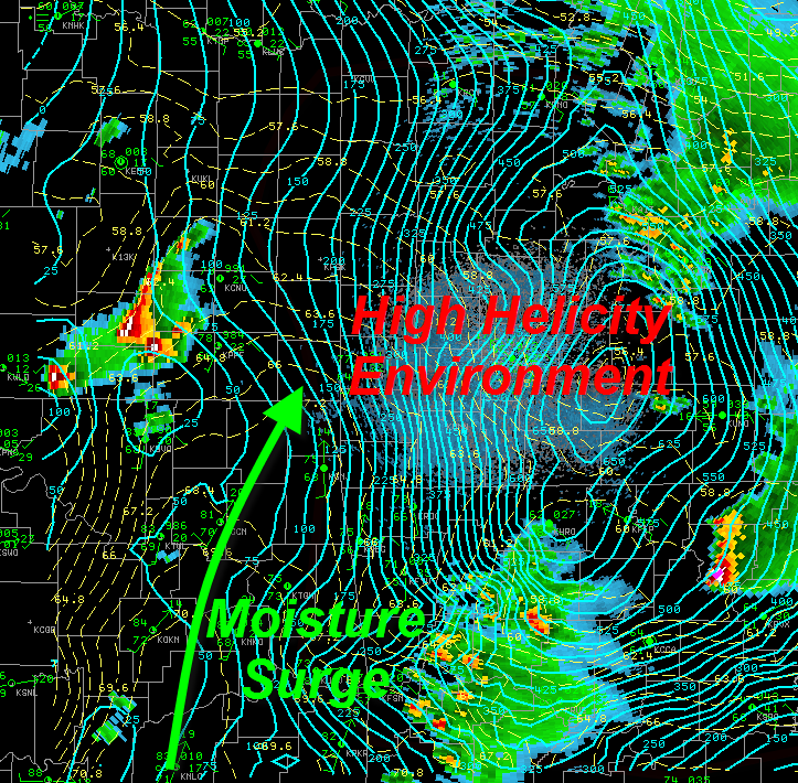
By early afternoon, the low pressure over Kansas began to work its way to the east, bringing a narrow area of unstable air into eastern Kansas. Some clearing took place out ahead of the surface low. This allowed temperatures to increase into the upper 70s while dew points in the mid 60s surged North. This ripe environment was characterized by ample Convective Available Potential Energy (CAPE, a term for measuring atmospheric instability in terms of energy), and abundant wind shear in the lowest 6 kilometers of the atmosphere on the order of 50 to 70 knots. A modest capping inversion (a layer of warm air aloft) prevented thunderstorm development through 3:30 PM CDT. This actually allowed the airmass to further destabilize prior to thunderstorm initiation.

**TOP IMAGE: Approximate frontal positions at 4:00 PM CDT. The peach lines are contours of Convective Available Potential Energy (CAPE) with values >2000 J/kg present over southeast Kansas.
**Bottom IMAGE: Indicates a moisture surge (dew point contours in yellow) south of the warm front, and a high helicity (blue contours) airmass over Eastern Kansas and Southwest Missouri.
Explosive thunderstorm development took place over extreme southeast Kansas by 4:00 PM CDT. These thunderstorms rapidly acquired mid-level mesocyclones (rotation of the updraft as a result of significant atmospheric wind shear) and progressed east. As the supercells crossed into Cherokee, Crawford, and Bourbon counties in Kansas, the southernmost storm began to take a slight turn to the south. This slight change in direction effectively increased the low level helicity (horizontal rotation caused by wind shear in the lowest levels of the atmosphere) being ingested by the storm. This additional low level rotation worked in tandem with a complex arrangement of updraft and downdraft interactions to develop a tornado near the Labette and Cherokee county line in Kansas.

**IMAGE: Explosive thunderstorm development near and South of Parsons along the dryline at 4:00 PM CDT. Tornadogenesis occurred just after this still frame.
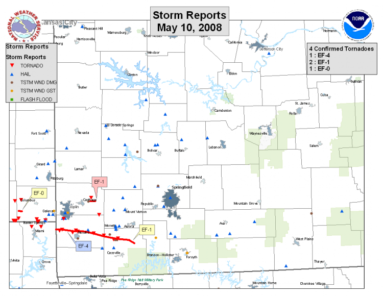
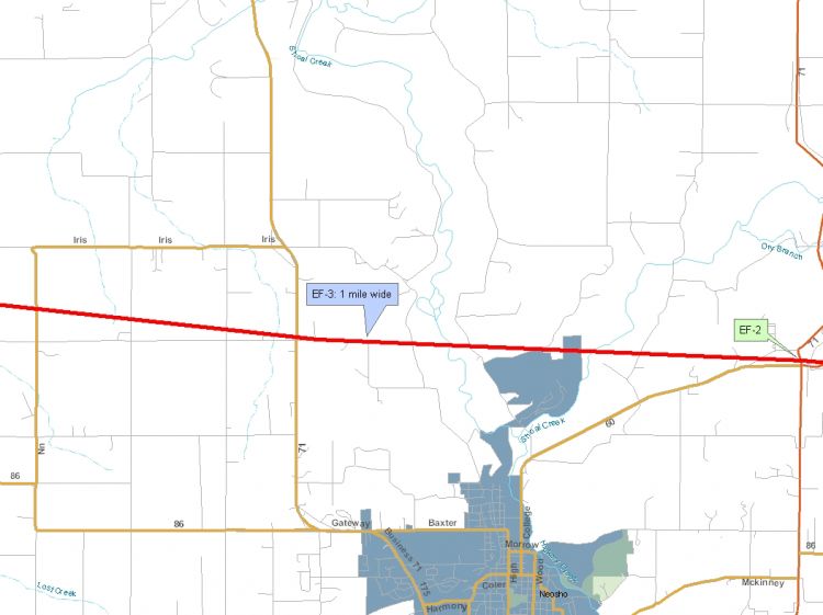
This massive supercell continued to the east-southeast, crossing into extreme northeast Oklahoma as it struck the town of Picher. The tornado produced significant damage at this point and was reported to be approaching 3/4 of a mile wide. At the same time, significant damage to roofs, vehicles, and vegetation occurred from Baxter Springs into Joplin as hail from golfball to softball size was abundant with this storm.

**IMAGE: Intense circulation as indicated by NWS Doppler Radar at 5:00 PM CDT. Reds and yellows indicate flow to the west-southwest while greens and blues indicate flow to the east-northeast. Other rotating storms are present over Jay county Oklahoma, Jasper and Lamar counties in Missouri, and one is developing at this time in McDonald county Missouri.
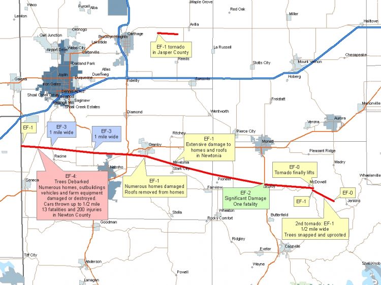
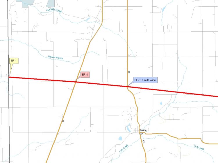
The tornado’s path of devastation crossed into Missouri near Iris road in Newton county where significant damage occurred. It continued on to cross Highway 43 north of Seneca and Highway 71 just North of Neosho. At this time, NWS Doppler radar in Springfield indicated over 130 knots of low level rotation (80+ knots away from the radar and 50+ knots toward the radar). The tornado continued to the east-southeast, causing significant damage in Newtonia and Purdy, as well as rural areas along the way. This tornado resulted in 15 fatalities and reports of more than 200 injuries in Missouri alone. Additional damage occurred occurred in Ottawa county Oklahoma. The Tulsa National Weather Service office has performed a damage survey on the Oklahoma portion of the tornado track.

Other tornado warnings were issued to the north of this main supercell for portions of Jasper county, and even as far north as Cedar county for areas of rotation that developed under supercells embedded within a line of storms. These supercells produced significant hail and straight line wind damage, as well as one tornado east of Carthage Missouri which unfortunately resulted in one fatality.
This mass of severe thunderstorms eventually experienced a weakening trend as it progressed to the east. A slightly more stable airmass was in place over this region as it had remained north of the warm front, and been dominated by cloud cover for much of the day. Other severe thunderstorms over portions of Arkansas also acted to cut off the rich moisture feed to storms over Missouri. All of these factors acted to slightly weaken the thunderstorms, and they even became a bit elevated as they moved east of Highway 65. Damaging straight line winds of up to 80 mph, damaging hail, and a funnel cloud were reported, but the ‘near-surface’ layer of the atmosphere had become more stable, and the tornado threat had diminished over Missouri.

IMAGE: The severe storms move into a region of weaker atmospheric instability at 8:00 PM CDT. CAPE is contoured in peach dashed lines and values are significantly lower than earlier in the event.


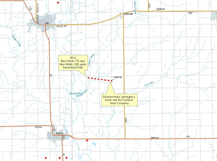
..EF-0 TORNADO WEST OF FAULKNER KANSAS...
A NATIONAL WEATHER SERVICE STORM SURVEY HAS INDICATED THAT AN EF-0 TORNADO
TOUCHED DOWN ON MAY 10TH...TWO MILES WEST OF FAULKNER. THE TORNADO HAD A
WIDTH OF 150 YARDS WITH MAXIMUM WINDS OF 70 MPH. THE TORNADO BEGAN NEAR
LOSTINE ROAD AND 120TH AT LATITUDE 37.10364 AND LONGITUDE -95.04998...AND ENDED
NEAR FALCON ROAD AND 100TH AT LATITUDE 37.09896 AND LONGITUDE -95.01347. THE
TORNADO DOWNED TREES AND CAUSED MINOR DAMAGE TO A HOME AND THE FAULKNER
GRAIN COMPANY ALONG A TWO-MILE INTERMITTENT PATH.


 Weather Story
 Weather Map
 Local Radar