 |
Tornado Outbreak - March 12th, 2006National Weather Service, Springfield, MO |
 |
An outbreak of severe thunderstorms and tornadoes hit the Missouri Ozark during the
afternoon and evening hours on March 12th, 2006. Numerous supercell thunderstorms
moved across the region spawning more than a dozen tornadoes...killing 2 people in
the Ozarks region...injuring more than 30 people...and damaging or destroying more
than 550 homes.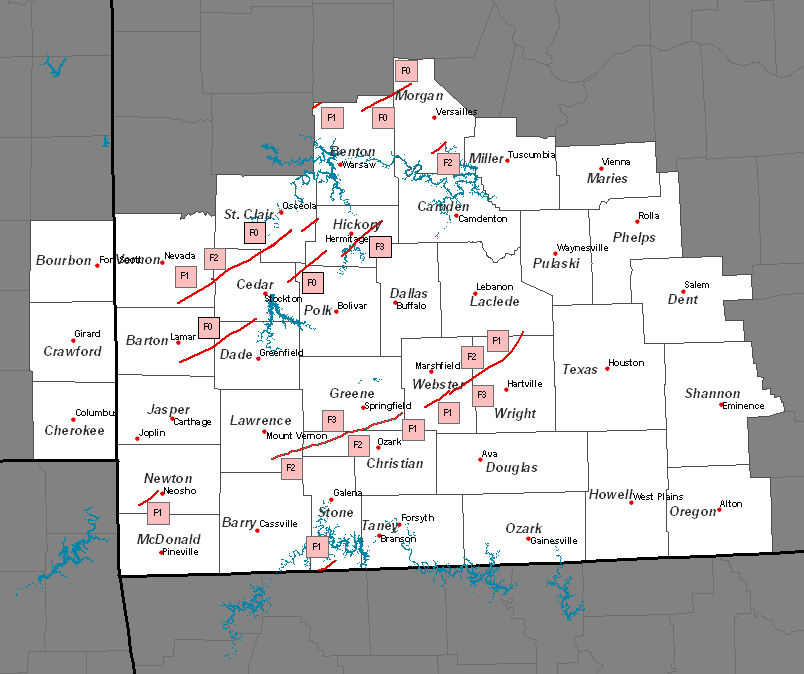
Tornado Path - Near Verona to SE Greene county
Sunday March 12th, 2006
F-Scale: F3 between Nixa and Clever
Path Length: ~40 miles Width: 1/4 to 1/2 mile
Time: 1008 - 1100 P.M.
Track Map
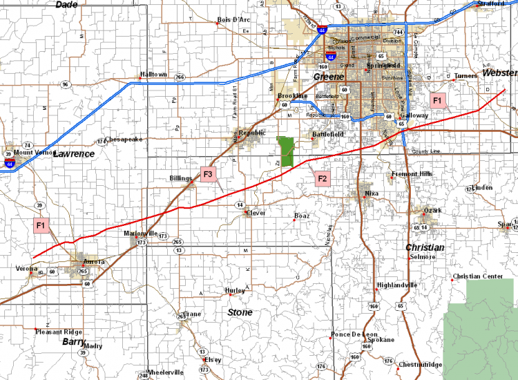
National Weather Service damage survey teams determined that a tornado touched down in
southern L
northeastward crossing into western Christian county just north of Marionville. The storm then
tracked across northwestern Christian county before crossing into southern Greene county just
south of
lifting between AD highway and D highway just west of the Greene-Webster county line in Greene
county.
The tornado touched down at approximately 1000 pm and remained on the ground for just under an
hour lifting at approximately 1100 pm. The majority of the damage along the path of the tornado was
f0 to f1 intensity and mostly to trees. The majority of homes in the damage swath sustained anywhere
from 25 percent to 75 percent roof damage as well as damage to exterior walls. A mobile home
was rolled across the highway west of Marionville and two homes were totally destroyed north of Clever.
The majority of the damage in Greene county was confined to trees and power lines...however there was
some structural damage to homes near the Greene-Christian county line.
Tornado Paths - Webster, Wright, and Laclede Counties
Sunday March 12th, 2006
Tornado 1:
F-Scale: F2 north of Fordland
Path Length: ~11 miles Width: 1/4 mile
Time: 1103 - 1120 P.M.
Tornado 2:
F-Scale: F3 near Duncan
Path Length: ~40 miles Width: 1/2 mile
Time: 1119 - 1150 P.M.
Track Map
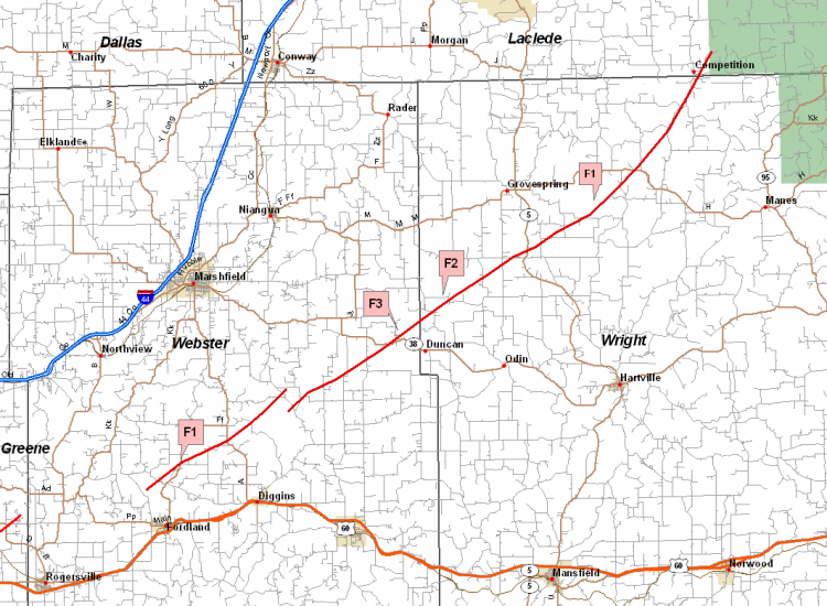
Event Summary
Tornado Paths - Benton and Morgan counties
Sunday March 12th, 2006
Tornado 1:
F-Scale: F0 west of Brandon
Path Length: ~5 miles Width: 200 yards
Time: 355 - 400 P.M. Tornado 2: Path Length: ~6 miles Width: 3/8 mile Time: 1025 - 1035 P.M. Tornado 3:
F-Scale: F2 in Gravois Mills
Sunday March 12th, 2006
F-Scale: F0 north of Cole Camp
Path Length: ~6 miles Width: 3/8 mile
Time: 1025 - 1035 P.M.
Track Map
.png)
Event Summary
At approximately 1025 pm CST Sunday, a 3/8 mile wide tornado path was noted extending from
3 miles southwest of Gravois Mills, across state highway 5 just south of the intersection of CR-5-14,
across the Gravois Arm of the Lake of the Ozarks, to 5 miles east of Gravois Mills before lifting.
Most of the damage was rated F0 to F1, restricted to damaged homes, damaged/destroyed
outbuildings, mobile homes, and downed trees on homes/cars/outbuildings. Five trailer
homes were severely damaged and one was overturned and essentially destroyed along
highway 5 about 2 miles south of Gravois Mills. A wood framed garage was lifted and
destroyed on the east of the Gravois Arm with the contents remaining in place.
Within the wide path of damage, a narrow track of strong F2 damage to 3 framed homes
was observed near the lake, one on the west side of the lake, and two on the east side.
Numerous other homes had roof damage.
Tornado Paths - Vernon, St. Clair, Hickory, Cedar, Barton, and Dade Counties
Sunday March 12th, 2006
Tornado 1:
F-Scale: F2 south of El Dorado Springs
Path Length: ~38 miles Width: 1/4 mile
Time: 847- 930 P.M.
Tornado 2:
F-Scale: F1 near Virgil City
Path Length: ~1 miles Width: 200 yards
Time: 855- 857 P.M.
Tornado 3:
F-Scale: F0 Barton County in Hickory
Path Length: ~40 miles Width: 30 yards Time: 918- 1018 P.M. Tornado 4: Path Length: ~9 miles Width: 1/4 mile Time: 1017- 1035 P.M.
F-Scale: F3 near Carsons Corner
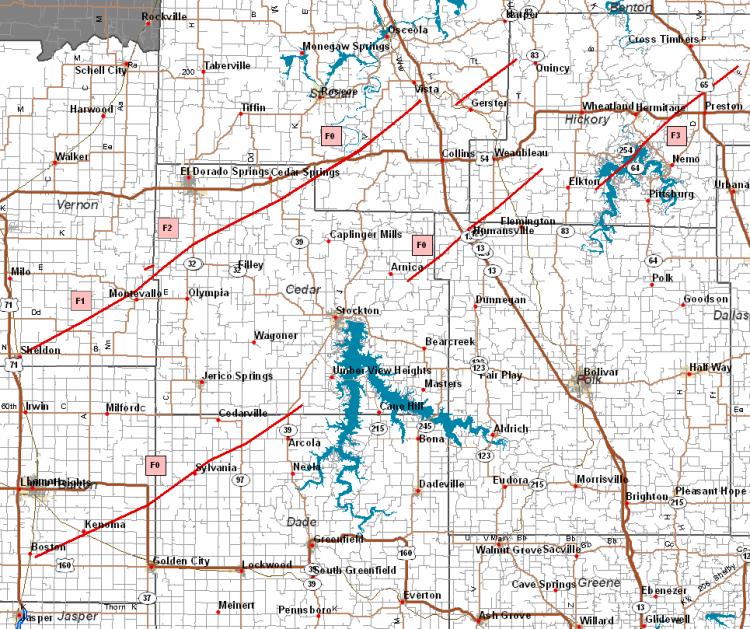
Event Summary
The path continued northeast from the Montevallo area
across the cedar county line to near U and highway
32...or about six miles south of El Dorado Springs. The
tornado intensified to an f2 as it struck a mobile home
park destroying several trailers...homes...and
outbuildings. Several vehicles...including farm
equipment...were tossed several hundred feet. There
were at least nine injuries at the trailer park.
Tornado intensity dropped back to an f1 as it moved
northeast across highway 39 near Hackleman corner
then to Leila store where several homes...a church...
and several outbuildings were severely damaged.
Just northeast of Leila store the intensity dropped to
f0. The tornado continued northeast across highway
54 near Hardyville and lifted about three miles south
of vista in St. Clair county.
Just north of Montevallo another f1 tornado track
was found from 1/2 mile southwest of Virgil City to 1/4
mile northeast of Virgil City in Cedar county. Several
homes and a church were damaged or destroyed. This
short-lived tornado had a width of 200 yards and
traveled almost one mile.
A fourth tornado track occurred from five miles west
of Pittsburg Missouri (Hickory county)...which is also on
the southwest shore of Pomme de Terre lake...to three
miles east of Hermitage Missouri. This was by far the
most intense tornado...reaching f3 intensity across the
Carsons corner area along highway 64. There was one
injury and numerous homes...mobile homes...
outbuildings...vehicles and boats damaged or destroyed.
The tornado moved northeast from damsite park as an f3
and crossed the Carsons corner area damaging a church
and destroying two stores...numerous buildings...part of
a hotel...and numerous vehicles...boats and campers. The
tornado crossed highway 64 and severely damaged a home.
The tornado continued northeast as an f1 and finally lifted
three miles east of Hermitage Missouri.
Tornado Paths - Newton County
Sunday March 12th, 2006
Tornado 1:
F-Scale: F1 southwest of Neosho
Path Length: ~7 miles Width: 1/8 mile
Time: 922- 936 P.M.
Tornado 2:
F-Scale: F0 just west of Neosho
Path Length: ~1/10 mile Width: 50 yards
Time: 922 P.M.
Track Map
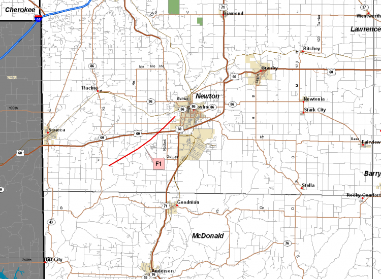
Event Summary
A National Weather Service storm survey concluded that a tornado touched down 4 miles east and 3 miles
south of Seneca in western Newton county. The tornado path was approximately 1/8 of a miles wide and
the damage was rated F1 intensity.
There was also a brief touchdown on the western side of the Neosho city limits. This tornado was also
1/8 of a mile wide. A well-built home sustained roof damage and there was also tree damage. This
tornado was rated F0 on the Fujita scale.
Tornado Path - Southwest of Lampe
Sunday March 12th, 2006
F-Scale: F1 just east of Carr Lane
Path Length: ~3 miles Width: 100 yards
Time: 1057 - 1102 P.M.
Track Map
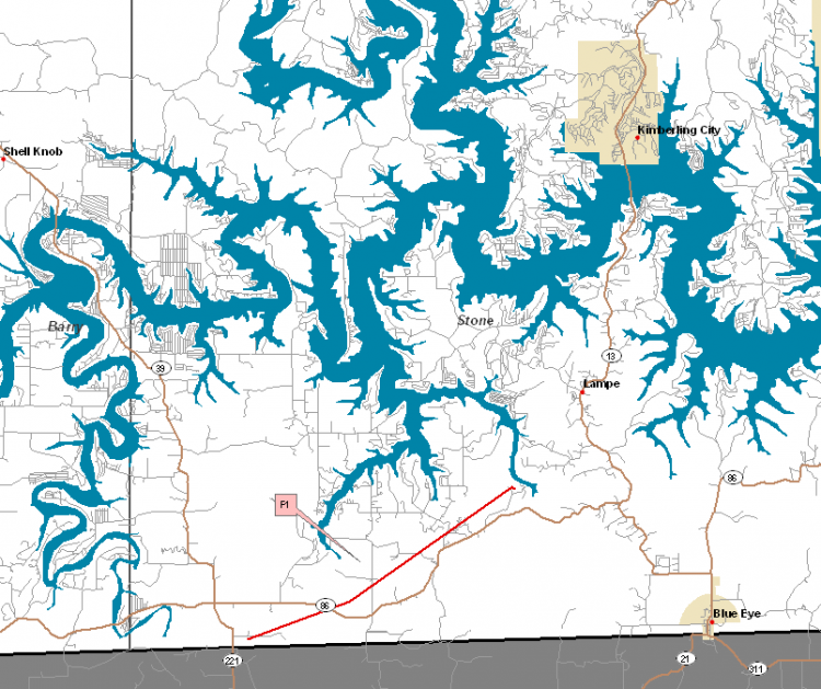
Event Summary
A long track tornado that began in Carroll county Arkansas crossed into southern Missouri into
southern Stone county just southeast of Carr Lane around 11 pm. The tornado remained on the
ground in Stone county for approximately 3 miles before lifting a few miles southwest of Lampe.
Along the path of the tornado in Stone county there was considerable tree damage with many large
trees uprooted. Some structures were also damaged and/or destroyed. The damage along the
path in Stone county was generally F1 intensity. The width of the damage path across Stone
county was about 100 yards.
HERE ARE SOME UPDATED STATISTICS ON THE MARTH 12TH TORNADO
OUTBREAK...THESE NUMBERS MAY STILL BE UPDATED AS ADDITIONAL
INFORMATION IS GATHERED. IN THE NATIONAL WEATHER SERVICE SPRINGFIELD
COUNTY WARNING AREA:
NUMBER OF TORNADOS: 13 (INCLUDING 3 F0`S, 4 F1`S, 3 F2`S, AND 3 F3`S)
NUMBER OF FATALITIES: 2
NUMBER OF INJURIES: 35
NUMBER OF HOMES DESTROYED: 202
NUMBER OF HOMES DAMAGED: 366 (NOT INCLUDING THOSE DESTROYED)
HERE IS A RUNDOWN OF THE PRELIMINARY STATISTICS FROM FOR EACH OF THE
13 TORNADO TRACKS THAT HAVE BEEN SURVEYED:
1) AT APPROXIMATELY 400 PM A TORNADO MOVED INTO EXTREME NORTHWEST
BENTON COUNTY FROM HENRY COUNTY BEFORE MOVING BACK NORTH OUT OF THE
COUNTY AND INTO PETTIS COUNTY. THE DAMAGE IN BENTON COUNTY WAS RATED
F1 INTENSITY ON THE FUJITA SCALE. THE TORNADO MOVED INTO BENTON
COUNTY AROUND 405 PM AND MOVED OUT OF THE COUNTY AT APPROXIMATELY
410 PM. TOTAL PATH LENGTH IN BENTON COUNTY WAS ABOUT 5 MILES WITH A
MAXIMUM WIDTH OF ABOUT 200 YARDS.
2) AT APPROXIMATELY 847 PM THE SECOND TORNADO TOUCH DOWN OCCURRED IN
SOUTHERN VERNON COUNTY NEAR THE TOWN OF SHELDON. THIS TORNADO MOVED
NORTHEAST ACROSS NORTHWEST CEDAR COUNTY AND INTO SOUTH CENTRAL ST.
CLAIR COUNTY WITH DAMAGE TRACKED TO ABOUT 3 MILES SOUTH OF VISTA IN
ST. CLAIR COUNTY. ADDITIONAL DAMAGE SURVEYS WILL BE CONDUCTED
THURSDAY NORTHEAST OF THIS AREA TO DETERMINE WHERE EXACTLY THIS
TORNADO LIFTED. THIS TORNADO WAS ON THE GROUND FOR APPROXIMATELY 38
MILES WITH A MAXIMUM WIDTH OF NEARLY A 1/4 MILE. THE DAMAGE
ASSESSMENT INDICATES THAT THE MAXIMUM INTENSITY OF THIS TORNADO WAS
F2 ON THE FUJITA SCALE JUST SOUTH OF EL DORADO SPRINGS.
3) AT APPROXIMATELY 855 PM THE THIRD TORNADO TOUCHDOWN OF THE DAY
WAS SPAWNED FROM THE SAME SUPERCELL WHICH PRODUCED TORNADO NUMBER 2.
THIS NEXT TORNADO WAS A BRIEF TOUCHED JUST NORTH OF MONTEVALLO AND
PRODUCED F1 INTENSITY DAMAGE ON THE FUJITA SCALE. THIS TORNADO WAS
ON THE GROUND FOR ABOUT 1 MILE WITH A MAXIMUM WIDTH OF AROUND 200
YARDS.
4) AT APPROXIMATELY 918 PM THE NEXT TORNADO TO TOUCH DOWN ON MARCH
12TH WAS IN BARTON COUNTY NEAR BOSTON. THERE WAS AN INTERMITTENT
DAMAGE TRACK FROM BARTON COUNTY NORTHEAST ACROSS
DADE...CEDAR...POLK...AND HICKORY COUNTY. THIS TORNADO WAS ON THE
GROUND FOR APPROXIMATELY 40 MILES WITH A MAXIMUM INTENSITY OF F0 ON
THE FUJITA SCALE AND A MAXIMUM WIDTH OF APPROXIMATELY 30 YARDS.
5) AT APPROXIMATELY 922 PM THE NEXT TORNADO TO TOUCH DOWN WAS IN
NEWTON COUNTY. THIS TORNADO TOUCHED DOWN APPROXIMATELY 6 MILES
SOUTHEAST OF SENECA AND MOVED NORTHEASTWARD LIFTING 3 MILES
SOUTHWEST OF NEOSHO. THIS TORNADO WAS ON THE GROUND FOR
APPROXIMATELY 7 MILES WITH A MAXIMUM WIDTH OF 1/8TH OF A MILE AND
HAD A MAXIMUM INTENSITY OF F1 ON THE FUJITA SCALE.
6) AT APPROXIMATELY 938 PM THE SAME STORM THAT SPAWNED TORNADO
NUMBER 5 IN NEWTON COUNTY WENT ON TO PRODUCE AN ADDITIONAL F0
TORNADO SHORTLY AFTER THE FIRST TORNADO LIFTED. THIS TORNADO TOUCHED
DOWN APPROXIMATELY 1/2 MILE WEST OF NEOSHO AND WAS ON THE GROUND FOR
1/10TH OF A MILE.
7) THE NEXT TORNADO TO TOUCH DOWN WAS IN LAWRENCE COUNTY AT
APPROXIMATELY 1008 PM AND WAS SPAWNED BY THE SAME SUPERCELL WHICH
PRODUCED THE TORNADOES IN NEWTON COUNTY. THIS TORNADO BEGAN ITS PATH
JUST NORTH OF VERONA IN LAWRENCE COUNTY AND CONTINUED
EAST-NORTHEASTWARD THROUGH NORTHWESTERN CHRISTIAN AND SOUTHEASTERN
GREENE COUNTIES LIFTING JUST WEST OF THE WEBSTER GREENE COUNTY LINE
BETWEEN A HIGHWAY AND AD HIGHWAY. THIS TORNADO WAS ON THE GROUND FOR
APPROXIMATELY 40 MILES WITH A MAXIMUM WIDTH OF 1/2 MILE. THE MOST
INTENSE DAMAGE WITH THIS STORM OCCURRED BETWEEN NIXA AND BILLINGS
AND THIS TORNADO WAS RATED WITH A MAXIMUM INTENSITY OF F3 ON THE
FUJITA SCALE.
8) AT APPROXIMATELY 1017 PM THE NEXT TORNADO TOUCH DOWN OCCURRED IN
HICKORY COUNTY 5 MILES WEST OF PITTSBURG AND CONTINUED ON THE GROUND
TO 3 MILES EAST OF HERMITAGE. THIS TORNADO WAS ON THE GROUND FOR
APPROXIMATELY 9 MILES AND HAD A MAXIMUM WIDTH OF 1/4 MILE. THE
MAXIMUM INTENSITY OF THIS TORNADO WAS F3 ON THE FUJITA SCALE.
9) THE NEXT TORNADO TO TOUCH DOWN WAS IN MORGAN COUNTY AROUND 1025
PM APPROXIMATELY 3 MILES SOUTHWEST OF GRAVOIS MILLS. THIS TORNADO
WAS ON THE GROUND FOR ABOUT 6 MILES WITH A MAXIMUM WIDTH OF
APPROXIMATELY 3/8TH OF A MILE. THE MAXIMUM INTENSITY OF THIS TORNADO
WAS RATED F2 ON THE FUJITA SCALE.
10) THE NEXT TORNADO TO AFFECT THE NATIONAL WEATHER SERVICE
SPRINGFIELD`S COUNTY WARNING AREA WAS IN SOUTHERN STONE COUNTY AT
AROUND 1057 PM. THE TORNADO CROSSED THE STATE LINE FROM CARROLL
COUNTY ARKANSAS INTO SOUTHERN STONE COUNTY AND MOVED INTO SOUTHERN
STONE COUNTY 1 MILE EAST SOUTHEAST OF CARR LANE AND TRAVELED
NORTHEASTWARD FOR 3 MILES INTO STONE COUNTY. THE PATH WAS
APPROXIMATELY 100 YARDS WIDE WITH A MAXIMUM INTENSITY OF F1.
11) AT 1103 PM...THE NEXT TORNADO TOUCHED DOWN IN WEBSTER COUNTY
APPROXIMATELY 3 MILES NORTHWEST OF FORDLAND AND CONTINUED
NORTHEASTWARD FOR APPROXIMATELY 11 MILES LIFTING NORTH OF DIGGINS.
THIS TORNADO WAS RATED AN F2 INTENSITY ON THE FUJITA SCALE AND HAD A
MAXIMUM WIDTH OF APPROXIMATELY 1/4 MILE.
12) ANOTHER TORNADO TOUCHED DOWN AT APPROXIMATELY 1120 PM ABOUT 5
MILES NORTH OF DIGGINS AND CONTINUED NORTHEASTWARD INTO WRIGHT
COUNTY EVENTUALLY LIFTING AFTER CROSSING INTO SOUTHEAST LACLEDE
COUNTY NEAR COMPETITION. THIS TORNADO WAS ON THE GROUND FOR
APPROXIMATELY 31 MILES WITH A MAXIMUM WIDTH SLIGHTLY LARGER THAN 1/2
MILE WIDE. THE MAXIMUM INTENSITY WAS RATED F3 ON THE FUJITA SCALE.
13) THE FINAL CONFIRMED TORNADO TOUCHDOWN OF THE MARCH 12TH OUTBREAK
TOUCHED DOWN ABOUT 2 MILES WEST OF COLE CAMP IN NORTHERN BENTON
COUNTY AND MOVED NORTHEAST ACROSS HIGHWAY JJ TWICE. THE TORNADO
CONTINUED NORTHEAST AND EVENTUALLY MOVED INTO FAR NORTHERN MORGAN
COUNTY JUST SOUTH OF FLORENCE. THE DAMAGE INDICATES THAT THE TORNADO
WAS AN F0 ON THE FUJITA SCALE WITH A 17 MILE INTERMITENT PATH AND A
MAXIMUM WIDTH OF 175 YARDS.
HERE IS THE FUJITA SCALE:
F0: GALE TORNADO (40-72 MPH)
F1: MODERATE TORNADO (73-122 MPH)
F2: SIGNIFICANT TORNADO (113-157 MPH)
F3: SEVERE TORNADO (158-206 MPH)
F4: DEVASTATING TORNADO (207-260 MPH)
F5: INCREDIBLE TORNADO (260-318 MPH)
THE NATIONAL WEATHER SERVICE WOULD LIKE TO THANK THE MANY PEOPLE WHO
HAVE HELPED IN THE STORM SURVEY PROCESS.


 Weather Story
 Weather Map
 Local Radar