 |
Severe Storms and Flooding - Oct 31st - Nov 1st, 2004
National Weather Service, Springfield, MO
|
 |
Event Summary
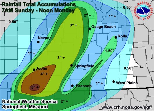
Between two and four inches of rain inundated much of the Missouri Ozarks Sunday and early Monday as a slow moving low pressure system crawled across the region.
The heaviest rain, with amounts greater than four inches, fell across portions of Newton and McDonald counties. (Click for storm total rainfall map) Amounts greater than three inches fell from Joplin to Springfield on north toward Warsaw and Versailles.
This marked the 20th time in October that measurable precipitation had fallen, with monthly total amounts ranging from 6 to 8 inches in many locations. The excessive rainfall resulted in widespread flooding of streets, streams, rivers and low water crossings, making trick or treating and the Monday morning commute nearly impossible in some locations.
In addition to the heavy rainfall, a warm front nosed northward into portions of the Ozarks early Monday morning, sending temperatures to near 70 degrees with very humid conditions. A cluster of heavy showers and thunderstorms developed along the surface cold front, feeding off this warm and unstable airmass that developed east of Springfield.
At least two brief tornadoes were spawned during the early-mid morning hours Monday near Northview in Webster county and near Mountian View.
..TIME..    ...EVENT...     ...CITY LOCATION...      ...LAT.LON...
..DATE..    ....MAG....     ..COUNTY LOCATION...ST.. ...SOURCE....
            ..REMARKS..

0515 AM     TORNADO          5 S NORTHVIEW           37.21N 93.00W
11/01/2004  F1               WEBSTER            MO   NWS STORM SURVEY

            A TORNADO DESTROYED SEVERAL BARNS, REMOVED A ROOF TO A
            HOME AND DOWNED NUMEROUS TREES OFF OF HIGHWAY B ALONG
            RIVER, LANDSLIDE AND RIDGE ROADS...TO AREAS NEAR HIGHWAY
            K TO THE EAST OF NORTHVIEW. DAMAGE PATH WAS ABOUT 6
            MILES LONG FROM 5 MILES SOUTH OF NORTHVIEW TO 4 MILES
            EAST OF NORTHVIEW. MAXIMUM DAMAGE PATH WIDTH WAS AROUND
            ONE QUARTER MILE WIDE ON LANDSLIDE RD.
Event Maps


 Weather Story
 Weather Map
 Local Radar