 |
Tornado and Other Severe Storms - May 26th, 2004National Weather Service, Springfield, MO |
 |
A tornado developed over western St. Clair county Wednesday evening (May 26, 2004), tracking eastward across southern portions of St. Clair county producing some areas of significant damage in and near the Roscoe, MO area. Other severe storms occurred across extreme southeast Kansas and west central MO.
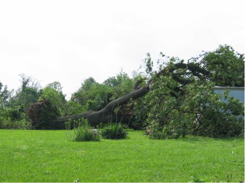
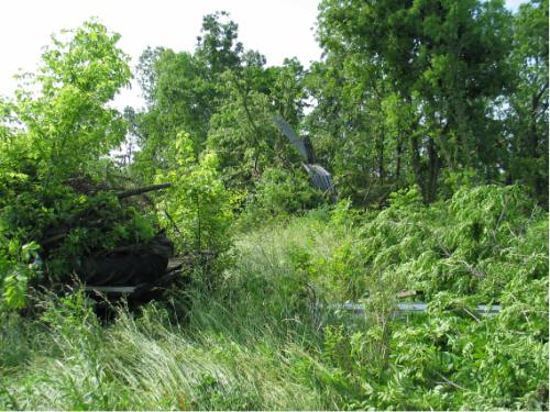
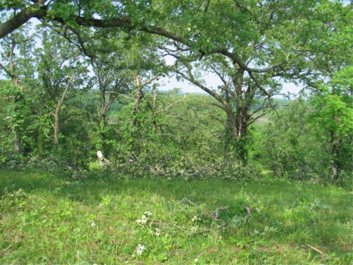
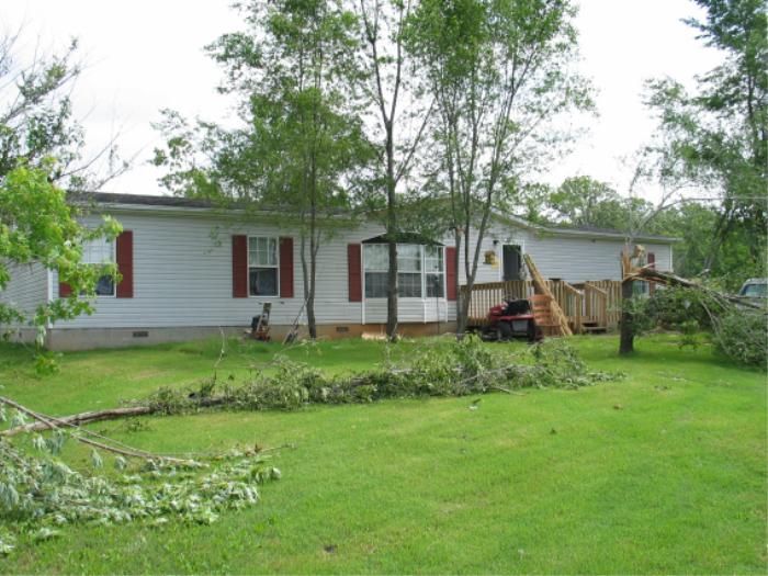
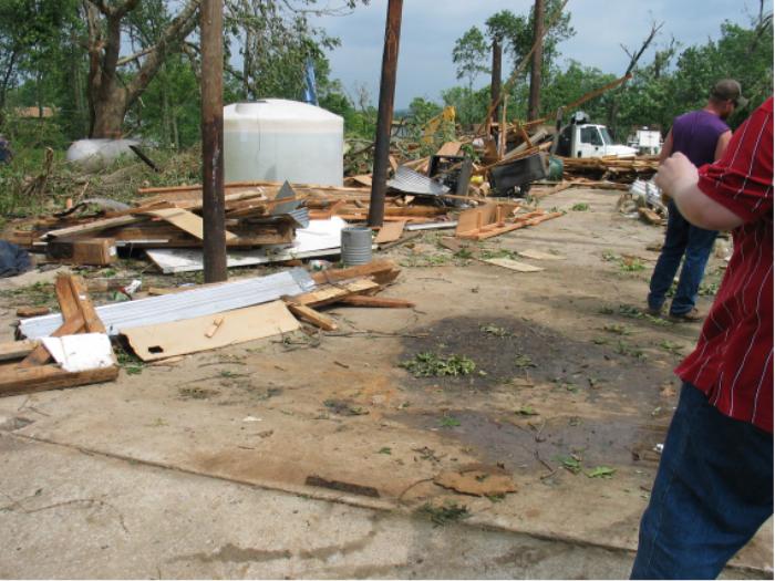
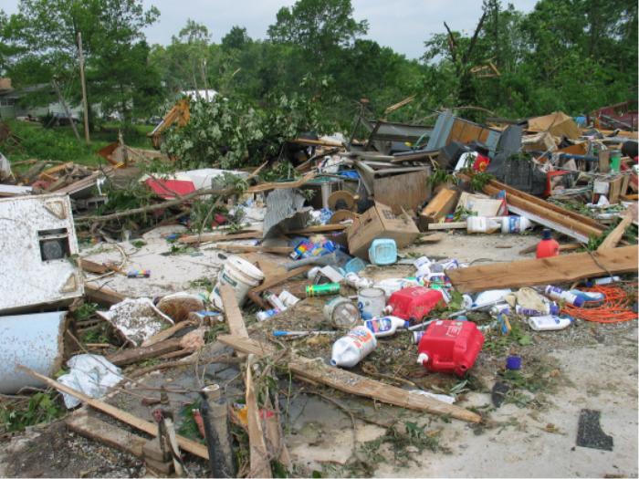
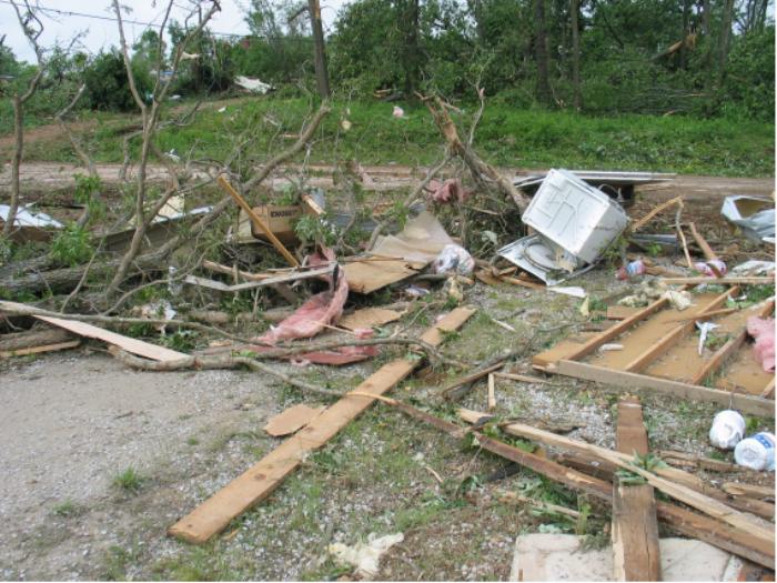
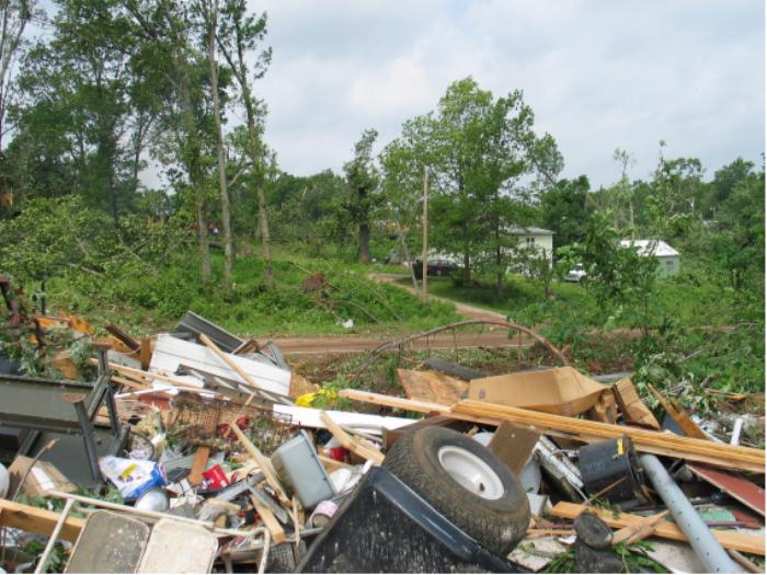
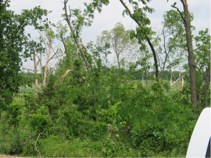
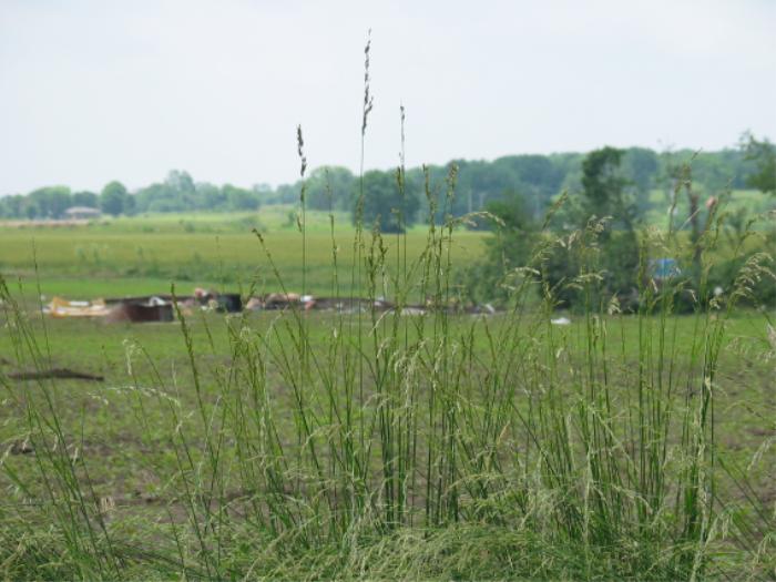
Tornado Damage Pictures from Saint Clair county
(Click on one of the thumbnails for the enlarged picture)


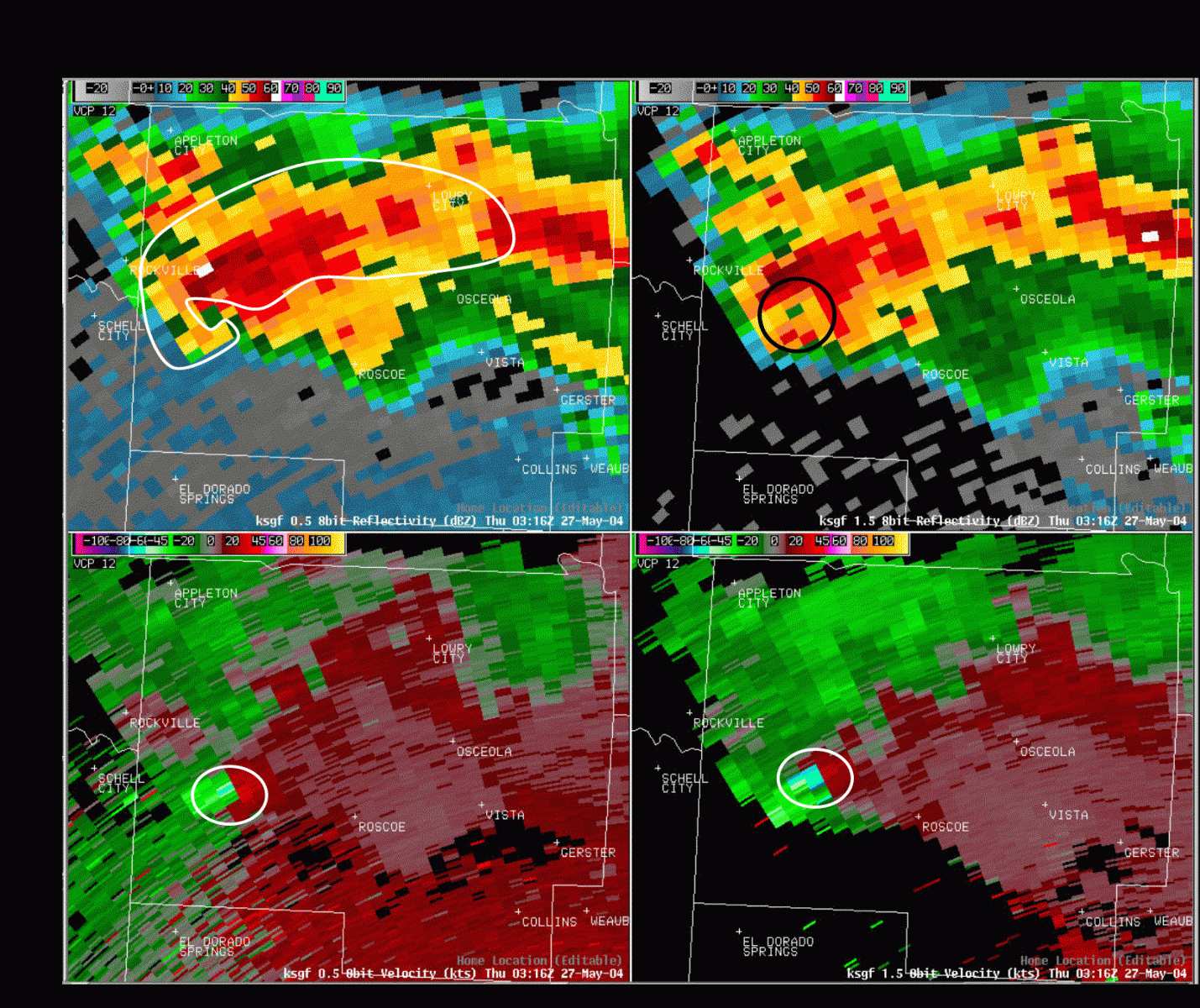
Radar Images from the Roscoe Tornado
Image 1 is a four panel radar image with the upper left hand panel a high resolution reflectivity image at the 0.5 degree elevation. The upper right panel is also high resolution reflectivity, but this is slightly higher up in the storm at elevation angle 1.5 degrees. The bottom two panels are of the doppler radar velocity images, the bottom left at 0.5 degree and the bottom right 1.5 degrees.
In image 1, the upper left hand reflectivity panel is already showing indications of a "hook echo" developing at 10:16 PM, just prior to the tornado touchdown. The upper right hand reflectivity image shows a BWER (Bounded Weak Echo Region circled in black), which is an indication that this storm not only has strong rotation but also a very powerful updraft. The bottom two images show the strong velocity couplet (greens/blues next to reds), circled in white. At this time the storm has a rotational velocity of over 100 mph.
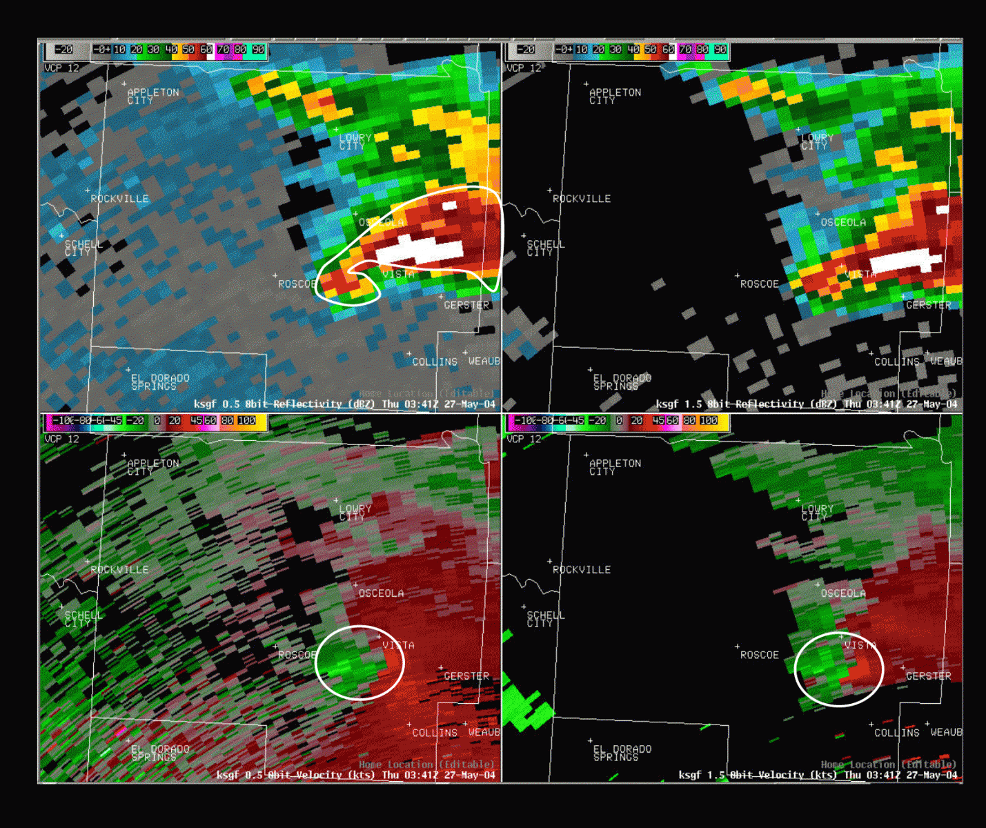
Image 2 is a four panel similar to image one. At this time the tornado was on the ground, and was located just west of Roscoe. By this time the rotation within the storm has intensified, with the nearly 150 mph of rotational velocity now detected at the lowest level (bottom right hand panel). In the upper right hand panel, very high reflectivity (whites and purples) are working their way to the surface, these high reflectivity values are likely due to large hail.
Image 3 is at the time the tornado did its most substantial damage, just east of Roscoe. A very well defined hook echo is now apparent on 0.5 degree elevation reflectivity (upper left hand panel). The high reflectivity that was located on the 1.5 degree elevation in the previous image, has now worked its way down to 0.5 degrees. Very large hail is now falling to the surface just south of Osceola and to the northeast of the tornado. The 1.5 degree reflectivity image shows a BWER again, which means the rotation and updraft in this storm remain very strong.
The reflectivity pattern in image 4 remains very impressive, with a well defined hook echo still visible at the 0.5 degree elevation. Damage surveys indicated that this is where the tornado lifted, and this fits well with the velocity data which shows the velocity couplet (or rotation) becoming much broader and weaker as 0.5 degree (bottom left hand panel). Notice the bright greens and blues are no longer located immediately next to the bright reds.
PUBLIC INFORMATION STATEMENT
NATIONAL WEATHER SERVICE SPRINGFIELD MO
733 PM CDT THU MAY 27 2004
...STRONG TORNADO STRIKES SOUTHERN SAINT CLAIR COUNTY...
A SUPERCELL THUNDERSTORM DEVELOPED OVER LINN COUNTY KANSAS WEDNESDAY
EVENING AND MOVED QUICKLY EAST SOUTHEASTWARD INTO SAINT CLAIR COUNTY
MISSOURI. A NATIONAL WEATHER SERVICE DAMAGE SURVEY TEAM WAS
DISPATCHED TO SAINT CLAIR COUNTY TODAY AND FOUND THAT A TORNADO DID
INDEED TOUCH DOWN APPROXIMATELY 6.5 MILES WEST OF THE TOWN OF ROSCOE
AT 1020 PM. THE TORNADO MOVED EASTWARD ACROSS SAINT CLAIR COUNTY
STRIKING THE SMALL COMMUNITY OF ROSCOE MISSOURI AT APPROXIMATELY
1030 PM. THE TORNADO CONTINUED EASTWARD FROM ROSCOE AND APPEARS TO
HAVE LIFTED APPROXIMATELY 6 MILES SOUTH OF OSCEOLA MISSOURI AT
AROUND 1040 PM. THE TORNADO TRACKED NEARLY PARALLEL AND JUST NORTH
OF COUNTY ROAD SW300...THEN DROPPED DOWN INTO THE SAC RIVER VALLEY
EAST OF ROSCOE...THEN EMERGED FROM THE VALLEY AND CONTINUED TO
PRODUCE DAMAGE FOR ANOTHER COUPLE OF MILES.
THERE WAS SIGNIFICANT TREE DAMAGE ALL ALONG THE PATH OF THE TORNADO
WITH THE MOST SIGNIFICANT AND WIDESPREAD TREE DAMAGE LOCATED JUST
EAST OF ROSCOE. DAMAGE IN THIS LOCATION WAS DETERMINED TO BE OF F2
MAGNITUDE WHERE NEARLY ALL TREES WITHIN A SMALL BUT DENSELY FORESTED
AREA WERE UPROOTED AND OR SHEARED OFF...INCLUDING SEVERAL VERY LARGE
AND DEEPLY ROOTED TREES. THERE WAS ALSO SOME LOW END F2 DAMAGE IN
THE CITY OF ROSCOE AS WELL...WHERE A BAIT AND TACKLE SHOP WAS
COMPLETELY LEVELED. THE MAJORITY OF THE DAMAGE IN THE CITY OF ROSCOE
WAS F0 AND F1 INTENSITY...INCLUDING THE FIRE HOUSE COMPLETELY
DESTROYED AND SIGNIFICANT STRUCTURAL DAMAGE TO A RESTAURANT ACROSS
THE STREET FROM THE FIRE HOUSE. THE TORNADO PRODUCED ADDITIONAL F1
DAMAGE APPROXIMATELY 4 MILES WEST OF ROSCOE ALONG COUNTY ROAD SW451
WHERE A MOBILE HOME AND BARN WERE DESTROYED. THERE WAS ALSO SIGNIFICANT TREE DAMAGE IN THIS LOCATION AS WELL.
ALONG THE PATH OF THE STORM THERE WERE NUMEROUS STRUCTURES THAT
SUSTAINED CONSIDERABLE DAMAGE...EITHER DIRECTLY FROM THE WIND OR
FROM BEING STRUCK BY FALLING TREES. THERE WERE A FEW STRUCTURES THAT
WERE COMPLETELY DESTROYED INCLUDING THE BAIT SHOP...THE FIRE
HOUSE...AND SEVERAL SMALLER WEAKER STRUCTURES.
IN ADDITION...THERE WAS SCATTERED DAMAGE TO THE SOUTH OF THE MAIN
TORNADO TRACK ALONG HIGHWAY 82. THIS DAMAGE WAS LIKELY CAUSED BY
DAMAGING STRAIGHT LINE WINDS THAT DEVELOPED TO THE SOUTH OF THE
TORNADO.
TORNADO STATISTICS:
PATH LENGTH: 12 MILES
MAXIMUM PATH WIDTH: AT LEAST A QUARTER MILE
MAXIMUM INTENSITY: F2 (STRONG TORNADO)
TOUCHDOWN TIME: 10:20 PM
TORNADO LIFTED AT: 10:40 PM
THE FUJITA SCALE:
F0 = LIGHT DAMAGE (WINDS <73 MPH)
F1 = MODERATE DAMAGE (WINDS 73-112 MPH)
F2 = CONSIDERABLE DAMAGE (WINDS 113-157 MPH)
F3 = SEVERE DAMAGE (WINDS 158-206 MPH)
F4 = DEVASTATING DAMAGE (WINDS 207-260 MPH)
F5 = INCREDIBLE DAMAGE (WINDS 261-318 MPH)
NOTE: ADDITIONAL INFORMATION ON THIS EVENT CAN BE FOUND ON OUR
WEBPAGE AT HTTP://WWW.CRH.NOAA.GOV/SGF (ALL LOWERCASE)
$$


 Weather Story
 Weather Map
 Local Radar