Springfield, MO
Weather Forecast Office
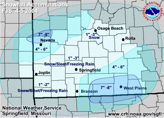
February 4th & 5th Winter Weather Event
A strong storm system developed across the central and southern Rockies. Tremendous amounts of moisture and lift moved into the Missouri Ozarks and southeast Kansas from the afternoon of the 4th into the nighttime hours. Forecasts were for 6 to 8 inches of snow across west central and central Missouri with lesser amounts heading to the south and east. Warmer air was expected to move into the area at several thousand feet and turn the precipitation over to sleet and freezing rain over southern Missouri.
Convective precipitation moved into southern Missouri by mid evening and kept the atmosphere cooled enough to where the precipitation remained as snow. Snow rates in the thunderstorm were one to two inches per hour with total snow amounts of 6 to 8 inches in south central Missouri.
Further north and west, the warmer air did move in aloft and changed the precipitation over to mostly sleet with some freezing rain. The convection to the south also limited the amount of precipitation that was able to make it to the north.
On the 5th, a band of snow developed across eastern Kansas and western Missouri during the morning hours and continue to move across this area during the day. Additional snow amounts of 2 to 4 inches developed across west central Missouri.
Here is the final snow map from the winter event of the 4th and 5th.
Current Hazards
Experimental Graphical Hazardous Weather Outlook
Submit a storm report
Local Storm Reports
Current Conditions
Observations
Lake Levels
Snowfall Analysis
Road Conditions
Satellite
CoCoRaHS
Graphical Conditions
Precip. Analysis
Forecasts
Forecast Discussion
Fire Weather
Aviation
GIS Forecast Maps
Activity Planner
Severe Weather
Winter Weather
Hurricanes
FAA Center Weather
Space Weather
Climatology
Records and Normals
Monthly Climate Summary
Local
National
Drought
Climate Science
Astronomical Data
US Dept of Commerce
National Oceanic and Atmospheric Administration
National Weather Service
Springfield, MO
Springfield-Branson National Airport
5805 West Highway EE
Springfield, MO 65802-8430
Business: 417-863-8028 Recording: 417-869-4491
Comments? Questions? Please Contact Us.


 Weather Story
 Weather Map
 Local Radar