 |
Severe Storms and Flooding - April 30th - May 1st, 2004
National Weather Service, Springfield, MO
|
 |
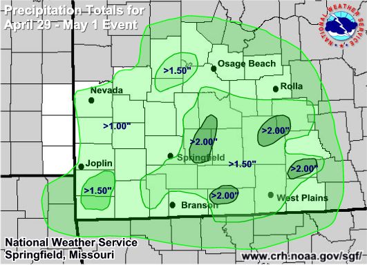
Event Summary
This was the second system in a week that brought severe storms and flooding to the Missouri Ozarks and southeast Kansas. Another slow moving cold front pushed into the region by the afternoon of April 30th. Showers and thunderstorms with heavy rain occurred during the morning and afternoon hours across portions of central and south central Missouri leaving the ground mostly saturated. Some isolated severe storms developed with large hail, however the majority of the storms were just producing torrential rainfall.
Thunderstorms formed into a complex during the evening hours of the 30th and extended into the early morning hours of May 1st. The heaviest rainfall occurred across southern Missouri in areas where major flooding occurred just one week prior. With ground levels remaining nearly saturated from the previous weeks heavy rain, it did not take much additional heavy rain to flood these same areas again.
While the heaviest rainfall ended early on the morning of May 1st, some light to moderate rain continued to develop behind the front as upper level energy moved through. Rain finally ended from west to east during the evening of May 1st.
Despite the end of the rainfall, low water crossings remained flooded into the late night hours of May 1st and early morning on May 2nd.
Event Storm Reports
PRELIMINARY LOCAL STORM REPORT
NATIONAL WEATHER SERVICE SPRINGFIELD MO
0327 AM CDT SUN MAY 02 2004
..TIME.. ...EVENT... ...CITY LOCATION... ...LAT.LON...
..DATE.. ....MAG.... ..COUNTY LOCATION...ST.. ...SOURCE....
..REMARKS..
1025 AM HAIL 5 S CAMDENTON 37.93N 92.75W
04/30/2004 1.00 INCH CAMDEN MO LAW ENFORCEMENT
0240 PM HAIL 5 S CRESTLINE 37.10N 94.70W
04/30/2004 0.88 INCH CHEROKEE KS BROADCAST MEDIA
REPORTED BY BROADCAST MEDIA.
0830 PM HAIL DIGGINS 37.17N 92.87W
04/30/2004 0.75 INCH WEBSTER MO BROADCAST MEDIA
1100 PM FLASH FLOOD DIGGINS 37.17N 92.87W
04/30/2004 WEBSTER MO AMATEUR RADIO
FLOODING OVER HIGHWAY 60 NEAR DIGGINS
1115 PM FLOOD TURNERS 37.18N 93.15W
04/30/2004 GREENE MO AMATEUR RADIO
MINOR FLOODING OVER HIGHWAY 125 NEAR OAK GROVE HEIGHTS.
1230 AM FLASH FLOOD FORDLAND 37.17N 92.95W
05/01/2004 WEBSTER MO AMATEUR RADIO
FLOODING OVER HIGHWAY Z.
0200 AM FLASH FLOOD 3 N HARTVILLE 37.29N 92.52W
05/01/2004 WRIGHT MO EMERGENCY MNGR
PEOPLE TRAPPED BY FLOODING ON LAKE FREDDIE ROAD.
1230 PM FLOOD PURDY 36.82N 93.92W
05/01/2004 BARRY MO LAW ENFORCEMENT
HIGHWAY C BETWEEN PURDY AND MCDOWELL CLOSED.
0130 PM FLOOD CONWAY 37.50N 92.83W
05/01/2004 LACLEDE MO LAW ENFORCEMENT
HIGHWAY J NEAR CONWAY CLOSED DUE TO HIGH WATER.


 Weather Story
 Weather Map
 Local Radar