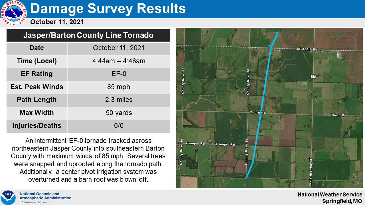
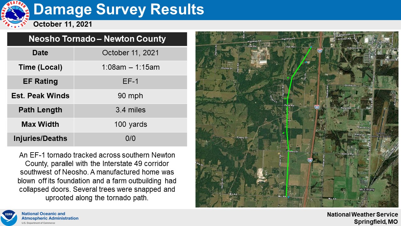
A strong area of low pressure brought severe weather including a couple of tornadoes to the area during the early morning hours of October 11th, 2021.
...HIGHEST WIND REPORTS...

Location                     Speed     Time/Date       Lat/Lon
Joplin ASOS                  59 MPH    0619 AM 10/11   37.15N/94.50W
1 NE Airport Drive           57 MPH    0553 AM 10/11   37.15N/94.50W
Springfield ASOS             52 MPH    0841 AM 10/11   37.23N/93.38W
Branson                      50 MPH    1055 AM 10/11   36.70N/93.23W
Bennett Spring State Park    48 MPH    1000 AM 10/11   37.70N/92.84W
Springfield Downtown Airport 46 MPH    1040 AM 10/11   37.22N/93.24W
Pittsburg AWOS               46 MPH    0515 AM 10/11   37.45N/94.73W
Mountain Grove RAWS          45 MPH    0645 AM 10/11   37.15N/92.27W
MO I-49 Nevada               45 MPH    0555 AM 10/11   37.84N/94.32W
Lampe                        45 MPH    0847 AM 10/11   36.58N/93.41W
Vichy Rolla ASOS             45 MPH    0632 AM 10/11   38.13N/91.77W
Monett AWOS                  45 MPH    0515 AM 10/11   36.90N/94.02W
Lebanon AWOS                 44 MPH    1055 AM 10/11   37.65N/92.65W
West Plains ASOS             44 MPH    1033 AM 10/11   36.88N/91.90W
Seymour                      43 MPH    0846 AM 10/11   37.15N/92.76W
Marshfield                   42 MPH    1132 AM 10/11   37.32N/92.92W
Blue Eye                     42 MPH    0945 AM 10/11   36.50N/93.39W
I-44 Joplin                  42 MPH    0615 AM 10/11   37.00N/94.60W
Branson                      41 MPH    1046 AM 10/11   36.66N/93.25W
Fort Leonard Wood AWOS       41 MPH    0554 AM 10/11   37.72N/92.12W
I-44 MM 126-Lebanon          41 MPH    1050 AM 10/11   37.65N/92.67W
Springfield-Greene County OE 41 MPH    0948 AM 10/11   37.22N/93.29W
Wah Kon Tah RAWS             41 MPH    0728 AM 10/11   37.90N/93.99W
Baxter Springs               40 MPH    0320 AM 10/11   37.02N/94.74W
Branson West AWOS            39 MPH    1035 AM 10/11   36.70N/93.40W
Pleasant Hope                39 MPH    0549 AM 10/11   37.49N/93.28W
Mt. Vernon                   39 MPH    0640 AM 10/11   37.08N/93.88W
Lamar                        39 MPH    0835 AM 10/11   37.49N/94.31W
Bolivar AWOS                 38 MPH    0755 AM 10/11   37.60N/93.35W
I-44 MM 47-Mt Vernon         38 MPH    0600 AM 10/11   37.09N/93.80W
Conway                       38 MPH    0800 AM 10/11   37.50N/92.84W
West Plains                  38 MPH    1038 AM 10/11   36.73N/91.87W
Lebanon                      37 MPH    0932 AM 10/11   37.68N/92.66W
Roby RAWS                    36 MPH    1139 AM 10/11   37.52N/92.12W
Branson                      36 MPH    0931 AM 10/11   36.64N/93.24W
Neosho AWOS                  36 MPH    0655 AM 10/11   36.82N/94.40W
Seymour                      34 MPH    0932 AM 10/11   37.26N/92.79W
7 W Hartville                32 MPH    0948 AM 10/11   37.28N/92.67W

Observations are collected from a variety of sources with varying
equipment and exposures. We thank all volunteer weather observers
for their dedication. Not all data listed are considered official.


 Weather Story
 Weather Map
 Local Radar