Snowfall during the Fall and Winter seasons supplies the majority of water to most mountainous regions, and Wyoming is no exception. Topography, winter weather patterns, and a host of other factors can combine to produce snowpacks that can have an excess of 50 inches of water equivalent each year.
During peak periods, the location of the melting snow can have as much impact on the potential for high water as the amount of snow itself. As one might guess the presence of large amounts of snow below 7000 ft. presents the greatest threat for rapid snowmelt problems. Even though flooding caused by snowmelt alone is rare, other factors combined with snowmelt can create out of bank flows very easily. Quick, low elevation snowmelt affected by wide temperature variations, can cause flooding easily and with little warning.
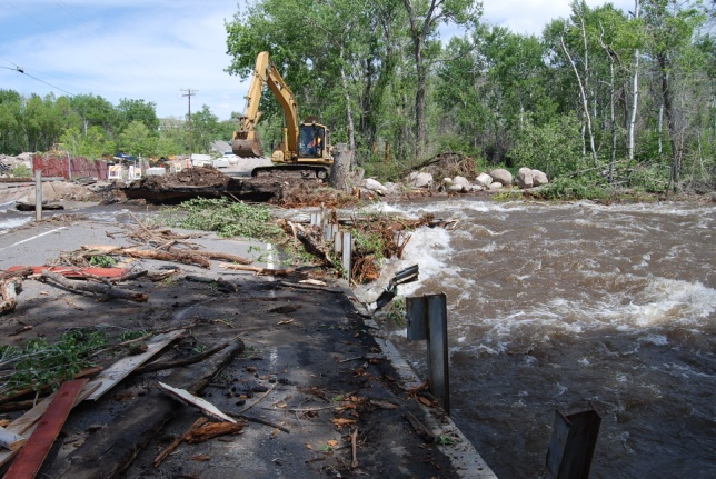
While it is true that flooding is rare due to snowmelt alone, quick low elevation melt, because it is nearest to population centers and is most easily affected by wide temperature variations, can create out of bank flows with little warning.
Rapid snow melt was the main contributing factor of the flooding in the Wind River Basin during the early summer months of 2010 and again in 2011. Unseasonably cool spring weather and above normal snowpack, historically high in some portions of Wyoming in 2011, followed by a swift warm up caused rapid snow melt in many areas across the state. Rivers were quickly overwhelmed by the surge of water resulting in flooding in many areas, especially in uncontrolled rivers near mountain slopes.
Wyoming Snowpack and Precipitation Data
There are numerous websites available to you for keeping abreast of the latest snowpack and precipitation trends across the state. Whether by individual river basin, station or the entire state, the links in the table below should assist you in finding the snow and precipitation information for which you are looking. Some great snowpack data and other related hydrologic links are found online by clicking here.
Since the 1930s, the Natural Resources Conservation Service (NRCS) has operated and maintained an extensive snowpack monitoring network across the West. This network, now called SNOTEL (for SNOwpack TELemetry), collects snowpack data to assist hydrologists and others in producing water supply forecasts.
Climate studies, air and water quality investigations, and resource management concerns are all served by the modern SNOTEL network. The high-elevation watershed locations and the broad coverage of the network provide important data collection opportunities to researchers, water managers, and emergency managers for natural disasters such as floods.
Visit the NRCS Snow Website or to learn more about the SNOTEL network download their SNOTEL Brochure.
*Portions of this information were excerpted from the NRCS website.
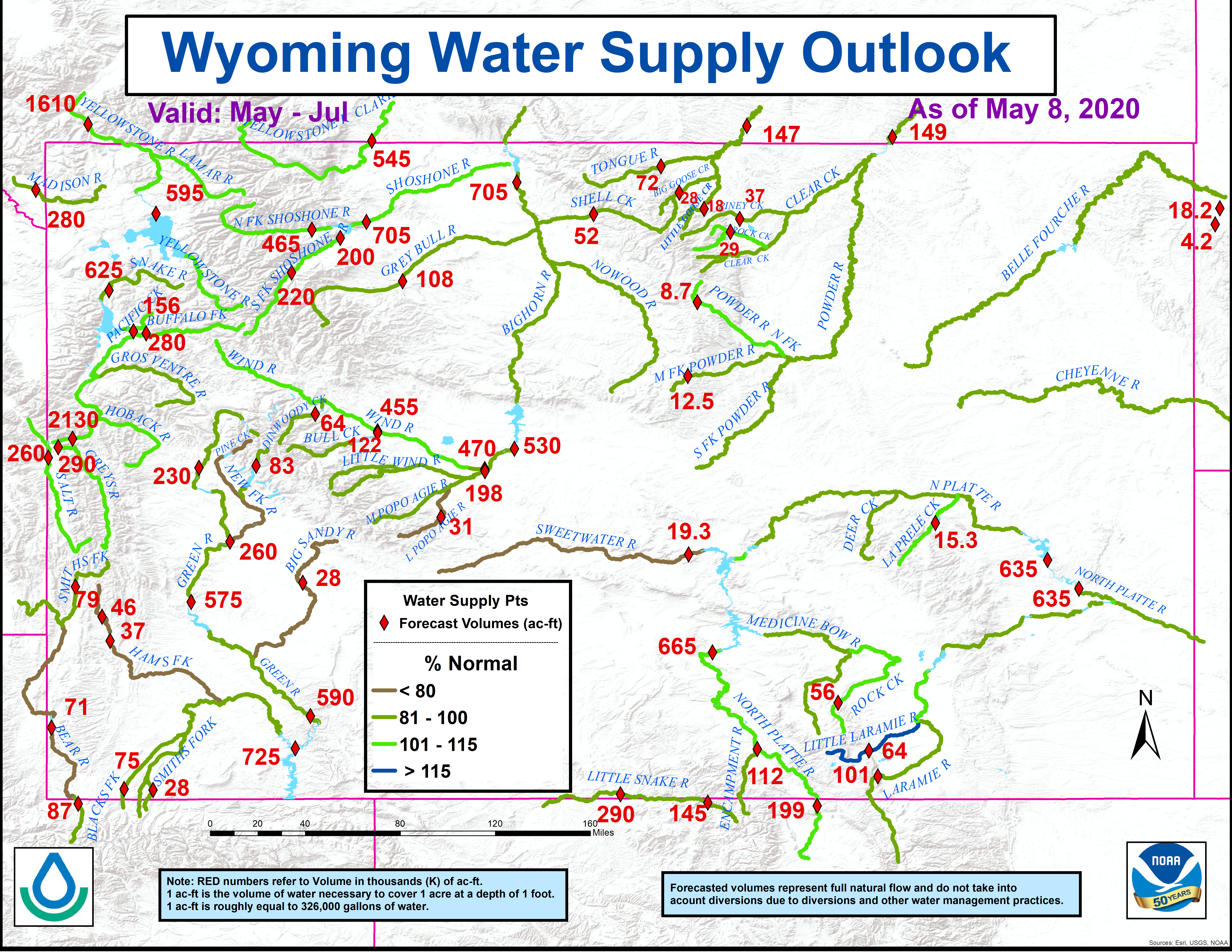
Wyoming Water Supply Outlook and Graphics

The most recent Wyoming water supply forecast is provided by NWS hydrologists and is available online by visiting here.
The forecast is updated monthly during the months of January through June.
Wyoming Spring Flood Potential Outlook
Keep up-to-date with the current Wyoming flood potential outlook by clicking here (or see the image to the right). This outlook is generated monthly from January through April providing snowpack and flood potential information for river basins across the state. Occasionally, an additional outlook is created early in May to highlight very high potential areas.
Wyoming River Basin Monthly Precipitation Totals
Monthly precipitation totals obtained from automated and manual observing stations are used to generate a monthly map of total precipitation across Wyoming. The state is segmented by river basin and color-coded for ease of use. You can find this monthly map online at:
Riverton (Western WY) Monthly Precipitation.
Cheyenne (Southeast WY) Monthly Precipitation.
Rapid City (Northeast WY) Monthly Precipitation.
Wyoming Monthly Precipitation.
Daily, Monthly, and Water Year Precipitation Totals Across Western Wyoming
Across western Wyoming, a new addition to the Internet allows precipitation watchers to keep an eye on daily precipitation fluctuations. Click here to view water year precipitation totals at western Wyoming cooperative observer network sites. Daily and monthly data for selected observing sites across western Wyoming can be found by clicking here.
For additional information, contact your local NWS office:


