National Weather Service United States Department of Commerce

Wyoming Flood Awareness - AHPS and Drought Information Sources

Crowheart gage during Wind River flooding


Index Flash Flooding Snowmelt / Run-off Flood Safety Burn Scar Flooding AHPS / Drought Social Media


The Advanced Hydrologic Prediction Service (AHPS) is a web-based suite of accurate and information-rich hydrologic forecast products. AHPS displays the magnitude and uncertainty of occurrence of floods or droughts, from hours to days and months, in advance. These graphical depictions provide useful information and planning tools for many economic and emergency managers. The hope is that AHPS will enable government agencies, private institutions, and individuals to make more informed decisions about risk based policies and actions to mitigate the dangers posed by floods and droughts.

The current group of AHPS products covers forecast periods ranging from hours to months. It also includes valuable information about the chances of flood or drought. This information is presented through user-friendly graphical products. The information, such as the flood forecast level to which a river will rise and when it is likely to reach its peak or crest, is shown through hydrographs. Other information includes:

  • the chance or probability of a river exceeding minor, moderate, or major flooding.
  • the chance of a river exceeding certain level, volume, and flow of water at specific points on the river during 90 day periods.
  • a map of the area surrounding the forecast point which provides information about major roads, railways, landmarks, etc. likely to be flooded, the levels of past floods, etc.

An additional feature of the AHPS Web site is a map of the river basin and various points along the river for which information is available. The data are not limited to information about floods, but can also provide information about potential droughts. This core suite may change over time reflecting the changing needs communicated by customers.

Click Here to view a map of observation and forecast points across Wyoming.


The Wyoming AHPS map interface shows river sites that have a forecast available (either year-round and/or during high water) or sites for which information has been requested by a customer. The bankfull and flood stages are also provided on USGS hydrographs. Real-time water data information provided by the USGS can be obtained by clicking here.

Farmers, ranchers, fishers, boaters, irrigation districts, and countless others are encouraged to visit the AHPS for planning and protection purposes. Other information abounds on the AHPS site including precipitation data, Google Earth compatible .kml and .kmz data links, and water temperature and quality information. Check it out, and keep yourself informed during the flood season.

AHPS Display
Example Image of the AHPS map for the state of Wyoming


Hydrograph for the Wind River near Riverton, in central Wyoming

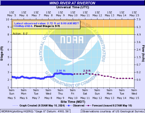
Current example of a height/time graph taken from the Wind River near Riverton in Central Wyoming


Throughout much of the first decade of the 21st century, Wyoming was mired in drought. Recent years have provided some relief, but the drought served as a reminder of the difficulties that arise in the arid west when snowpack and late spring and summer rains are inadequate to provide necessary water supplies. Population growth and new demands on water supplies across the west have made drought and water monitoring an important discussion topic.

Current Wyoming drought conditions

Latest drought conditions for Wyoming


For a complete listing of drought resources, forecasts, etc. please visit drought.gov. One of the more popular drought links is the U.S. Drought Monitor which is updated weekly throughout the year. You can view the current Wyoming drought status, along with other climate, precipitation, and snow pack data here: https://www.weather.gov/riw/drought

If the U.S. Drought Monitor depicts any portion of Wyoming at drought level D2 or worse, individual NWS weather forecast offices serving the state will issue a Drought Information Statement:
Riverton (Western WY) | Cheyenne (Southeast WY) | Rapid City (Northeast WY)
Salt Lake City (Uinta County) | Billings (Sheridan County)


For additional information, contact your local NWS office:

Cheyenne, WY Riverton, WY Billings, MT Rapid City, SD Salt Lake City, UT
800-269-6220 800-211-1448 406-652-0851 605-341-7531 801-524-5133