Overview (Work in Progress)
|
5 Tornadoes across southeast Colorado - 4/27/2012 Early morning tornadoes like those that occurred on April 27, 2012 are rare in Colorado. The last recorded significant after midnight tornado in southeast Colorado occurred at 1:30 AM on April 30th, 1942 across Bent and Kiowa counties. The April 27th tornadoes were spawned by a strong storm system interacting with low level moisture which was pulled westward from the central plains into southeast Colorado by the approaching storm system. No matter what time of day, conditions can be right for powerful storms to develop. Meteorologists from the National Weather Service in Pueblo surveyed the storm damage across southeast Colorado during Friday, April 28th. Preliminary findings indicate five tornadoes occurred; two in Prowers County, two in Kiowa County, and one in Bent County. What lessons can be learned from this episode... From interviews with government officials and the victims of the tornadoes... 1) People should have multiple ways to receive vital weather information. 2) People should stay informed with the latest weather information via NOAA All Hazards Weather Radio, local commercial radio and TV stations, and the NWS Pueblo web site. This episode was being advertised by the National Weather Service and the media a few days in advance. The timing of the severe weather was especially concerning, being around and after midnight. 3) We discovered that some people had their NOAA All Hazards Weather Radio receivers turned off during the episode. It is important to put your device in standy-by mode, so it will be able to alert and awaken you when a tornado or severe thunderstorm warning is issued by the National Weather Service. 4) Government officials can alert citizens of impending severe weather via a phone call. It is important to have a corded phone in your dwelling. Cordless phones that work with a base-station (which uses electricity) are vulnerable to power failures. If you have a base-station that has battery back up, the battery could potentially be bad, which would be a single point of failure for your cordless phone system. 5) Remember, sirens are OUTDOOR warning devices. There is no guarantee you will hear an outdoor warning siren in the middle of the night when you are asleep. |
|
Tornadoes Photos and Tracks:
Tornado #1:
 |
 |
 |
 |
| Track of the First Tornado | Metal Building Damage | Dwelling Damage | Corn Cob Forced into a Wooden Post from Strong Tornado Winds |
 |
 |
 |
 |
| Metal Pole Bent at 90 Degree Angle at its Base | Extensive Damage at a Ranch | More Damage at the Ranch | Virtually No Damage Done to the Ranch Owner's House |
Estimated Start Time: 1:45 AM MDT
Location: 4.4 miles east of McClave to 6 miles northeast of McClave (Bent County)
Estimated Highest Peak Wind: 125 mph (EF2)
Average Path Width: 200 Yards
Path Length: 6.2 Miles
Injuries / Fatalities: None
At the tornadoes peak, the width was approximately 300 yards and causing EF2 damage. A dwelling and metal building were struck, causing extensive damage to the buildings.
Tornado #2
 |
 |
 |
 |
| Track of Second Tornado | Destroyed Hog Farm | Hog Barn SW of Lamar | 18 Destroyed Hog Barns |
Estimated Start Time: 1:50 AM MDT
Location: 8 Miles SW of Lamar, Colorado
Estimated Highest Peak Wind: 120 mph (EF2)
Average Path Width: 200 Yards
Path Length: 2.0 Miles (Difficult to Determine due to Short Grass and Lack of Structures and Trees)
Injuries / Fatalities: None
A hog farm was hit, with 18 hog barns completely destroyed. There were no hogs on the farm at the time. Above is an aerial image taken by Denver TV media helicopter of the hog barns that were destroyed. The large feed bins were scattered to the north-northwest for approximately 1/3 mile, with a small debris field more than one mile long.
Tornado #3
 |
 |
 |
 |
| Track of the Third Tornado | Communications Tower | Dwelling Damage | Dwelling Damage |
 |
 |
 |
|
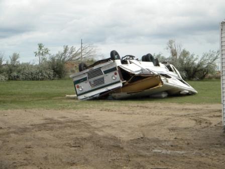
| Toppled Motor Home | Vehicle Damage | Remnants of a House |
Estimated Start Time: 1:58 AM MDT
Location: 3.75 Miles SE to 9 Miles NE of Lamar, Colorado
Estimated Highest Peak Wind: 120 mph (EF2)
Average Path Width: 100 Yards
Path Length: 21 Miles (Difficult to Determine due to lack of Structures Towards the End of the Path)
Injuries / Fatalities: 7 Minor Injuries
This tornado damaged or destroyed five dwellings. Two communications towers were toppled and a power substation was damaged near the beginning of the path.
Tornadoes #4 & #5
 |
 |
 |
 |
| Tornado #4 & #5 Tracks | Mobile Home Damage from Tornado #4 |
Damage from Tornado #5 | Damage from Tornado #5 |
Tornado #4:
Estimated Start Time: 2:33 AM MDT
Location: 1.5 Miles South of Chivington to Chivington (Kiowa County)
Estimated Highest Peak Wind: 105 mph (High-End EF1)
Average Path Width: 100 Yards
Path Length: 2 Miles
Injuries / Fatalities: 1 Minor Injuries
Tornado hit a mobile home and a church
Tornado #5:
Estimated Start Time: 2:40 AM MDT
Location: 3 Miles NE of Chivington (Kiowa County)
Estimated Highest Peak Wind: 115 mph (Low-End EF2)
Average Path Width: 50 Yards
Path Length: 1 Mile (Difficult to Determine due to Short Grass and Lack of Structures and Trees)
Injuries / Fatalities: None
A tornado struck an unoccupied mobile home and other ranch buildings. The mobile home had tie downs which were augered more than a foot into the ground. It was lofted approximately 30 feet, and bent around a truck
Radar:
Radar Animated GIFs
 |
 |
| Radar Reflectivity Volume Scans of the Complex of Storms; NWS Warning Included |
Radar Velocity Volume Scans of the Complex of Storms; NWS Warning Included |
Environment (Coming Soon)
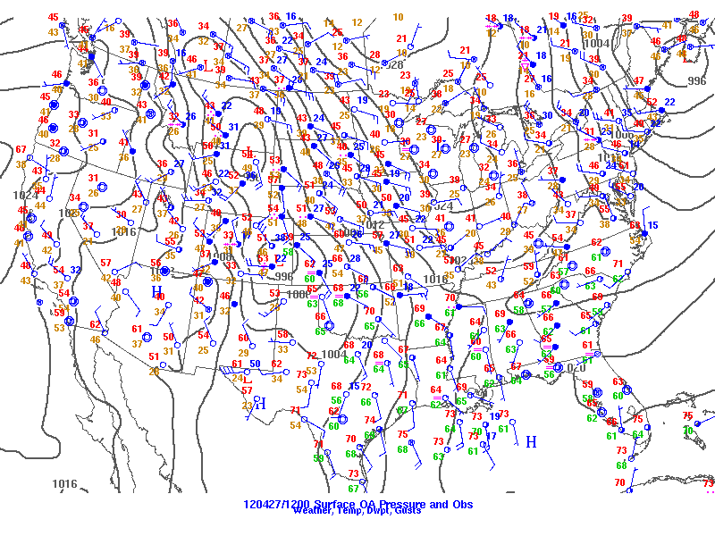
6 PM on April 26th, 2012 analyses on the top and and 12:00 AM MDT on April 27th, 2012 on the bottom.
 |
 |
 |
 |
| Figure 1: Caption | Figure 2: Caption | Figure 1: Caption | Figure 1: Caption |
 |
 |
 |
 |
| Figure 1: Caption | Figure 2: Caption | Figure 1: Caption | Figure 1: Caption |
Near-storm environment summary.
| Figure 4: Caption | Figure 5: Caption | Figure 6: Caption |
Additional environmental data.
| Figure 7: Caption | Figure 8: Caption | Figure 9: Caption |
 |
Media use of NWS Web News Stories is encouraged! Please acknowledge the NWS as the source of any news information accessed from this site. |
 |