
Early-season record warmth will persist across portions of the western and central U.S. through mid week, with high temperatures approaching 90 degrees from Texas to the Ohio Valley. Rain and mountain snow are possible across the Pacific Northwest Wednesday, with Severe Thunderstorms and wintry weather expected across the Northeast Thursday and Friday. Read More >
The start of Spring of 2024 continued to bring a progressive weather pattern across the region, with periods of mild and dry weather along with occasional colder and unsettled conditions associated with passing weather systems. One passing system through the middle of March brought widespread rain and snow to much of south central and southeast Colorado, with both Colorado Springs and Pueblo setting daily precipitation records. In fact, the 1.53 inches of precipitation recorded in Pueblo on March 14th also set a new maximum daily precipitation for the month of March, surpassing the 1.26 inches recorded on March 18th of 1998. Despite the good precipitation, a few passing systems through out March also brought windy conditions and critical fire weather conditions to portions of south central and southeast Colorado. April saw a mainly westerly flow pattern across Rockies, bringing periods of warm, dry and windy weather to south central and southeast Colorado. This pattern also brought increased fire danger to much of the snow free areas across the region. Two weather systems moved across eastern Colorado towards the end of April, bringing widespread rain and higher elevation snow to portions of the eastern mountains and plains. May brought an active weather pattern, especially through the middle of the month and again at end of the month. In typical Colorado May fashion, Mother's Day weekend saw widespread precipitation and heavy mountain snowfall, while the end of the month featured strong to severe thunderstorms across the southeast Plains. In the 3 day period from May 9th through May 11th, Alamosa recorded 1.46 inches of precipitation (rain and melted snow), which is roughly 20 percent of Alamosa's annual precipitation (7.39 inches)!
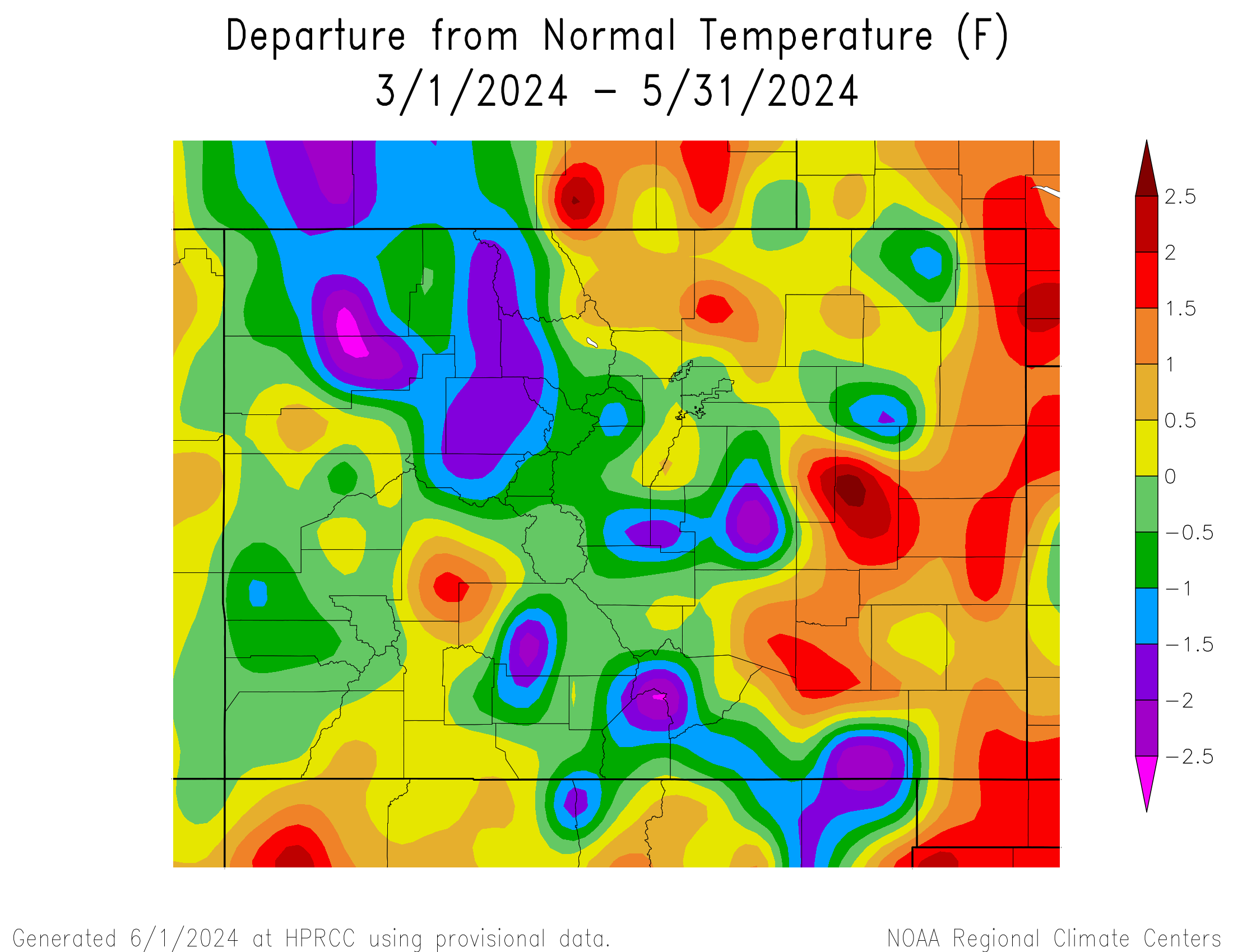
The following graphics depict seasonal temperature and precipitation departures from normal across the state for the Spring of 2024.
 |
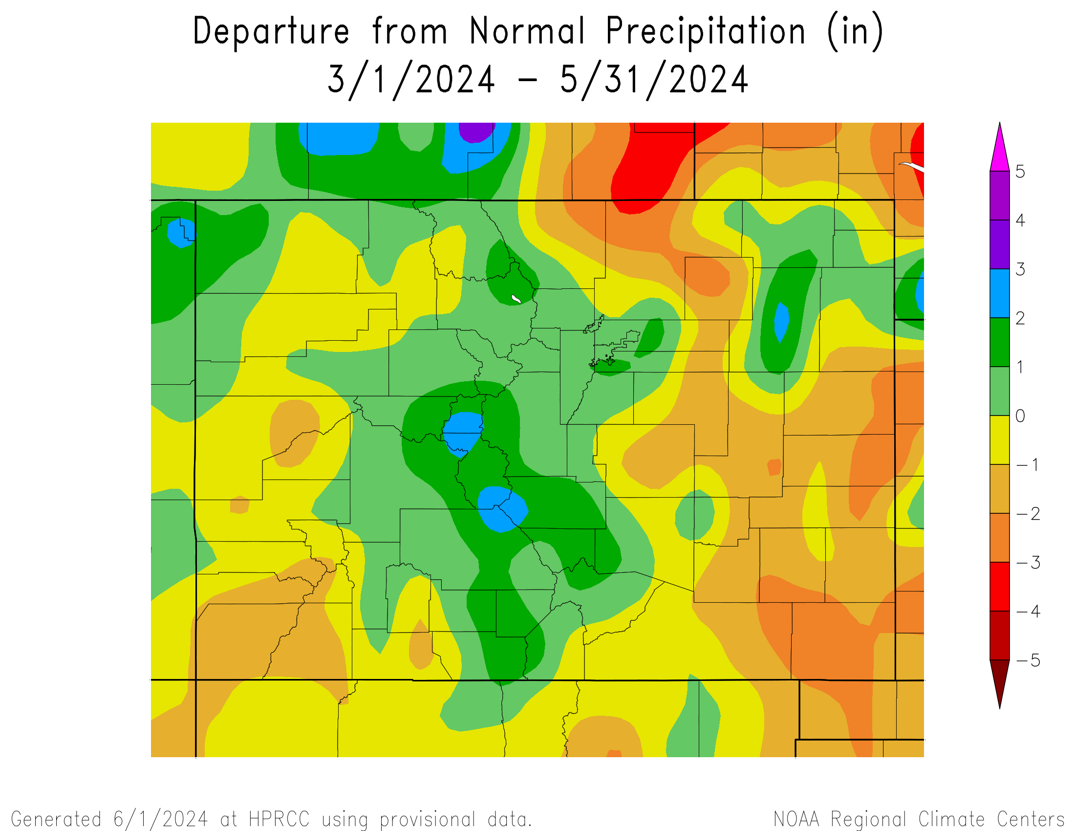 |
The preliminary average temperature for the Spring of 2024 in Alamosa was 43.3 degrees. This is 0.2 degrees above normal and makes the Spring of 2024 the 19th warmest on record in Alamosa. This remains well below the warmest Spring of 2020 when the average Spring temperature was 46.4F. Alamosa recorded 3.01 inches of precipitation through the Spring of 2024. This is 1.30 inches above normal and makes the Spring of 2024 the 11th wettest record in Alamosa. This remains well behind the wettest Spring of 1942, when 3.74 inches of precipitation was recorded. Alamosa recorded 17.4 inches of snow throughout the Spring (14.5" in March), which is 8.8 inches above normal. This brings the 2023-24 seasonal snowfall tally in Alamosa to 30.9 inches, which is 3.0 inches above normal.
(click here for a more detailed Spring of 2024 Climate Summary in Alamosa)
The preliminary average temperature for the Spring of 2024 in Colorado Springs was 49.5F. This is 0.9 degrees above normal and makes the Spring of 2024 the 13th warmest on record in Colorado Springs. This remains well below the warmest Spring of 2012, when the average Spring temperature was 53.4 degrees. Colorado Springs recorded 4.05 inches of precipitation through the Spring. This is 0.18 inches below normal and makes the Spring of 2024 the 67th driest on record, and well behind the wettest Spring of 1957, when 12.13 inches of precipitation recorded in Colorado Springs. Colorado Springs recorded 13.9 inches of snow throughout the Spring (13.3" in March). This is 2.1 inches above normal and makes the Spring of 2024 the 56th snowiest Spring on record in Colorado Springs, which remains well behind the 63.1 inches of snow that fell in the Spring of 1957. This brings the 2023-24 seasonal snowfall tally in Colorado Springs to 50.6 inches, which is 18.0 inches above.
(click here for a more detailed Spring of 2024 Climate Summary in Colorado Springs)
The preliminary average temperature for the Spring of 2024 in Pueblo was 52.9F. This is 0.7 degrees above normal and makes the Spring of 2024 tied as the 22nd warmest Spring on record in Pueblo, though well behind the warmest Spring of 1981 when the average Spring temperature was 55.8 degrees. Pueblo recorded 3.76 inches of precipitation throughout the Spring. This is 0.20 inches below normal and makes the Spring of 2024 the 57th wettest on record in Pueblo and well behind the wettest Spring of 1957 when 9.57 inches of precipitation was recorded. Pueblo recorded 3.2 inches of snow throughout the Spring (3.2" in March). This is 4.7 inches below normal and makes Spring of 2024 the 32nd least snowiest Spring on record in Pueblo. This brings the 2023-24 seasonal snowfall tally in Pueblo to 22.2 inches, which is 6.1 inches below normal.
(click here for a more detailed Spring of 2024 Climate Summary in Pueblo)
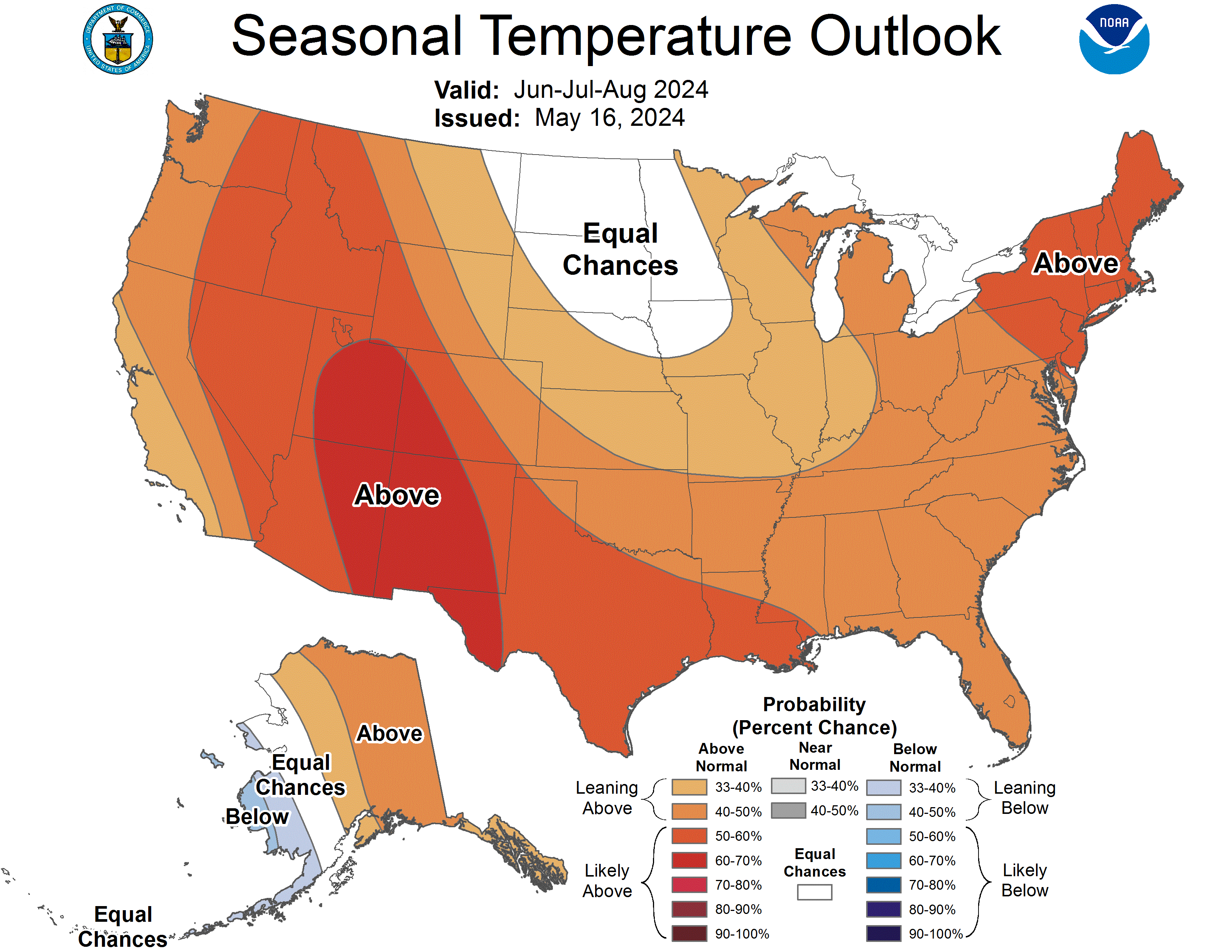
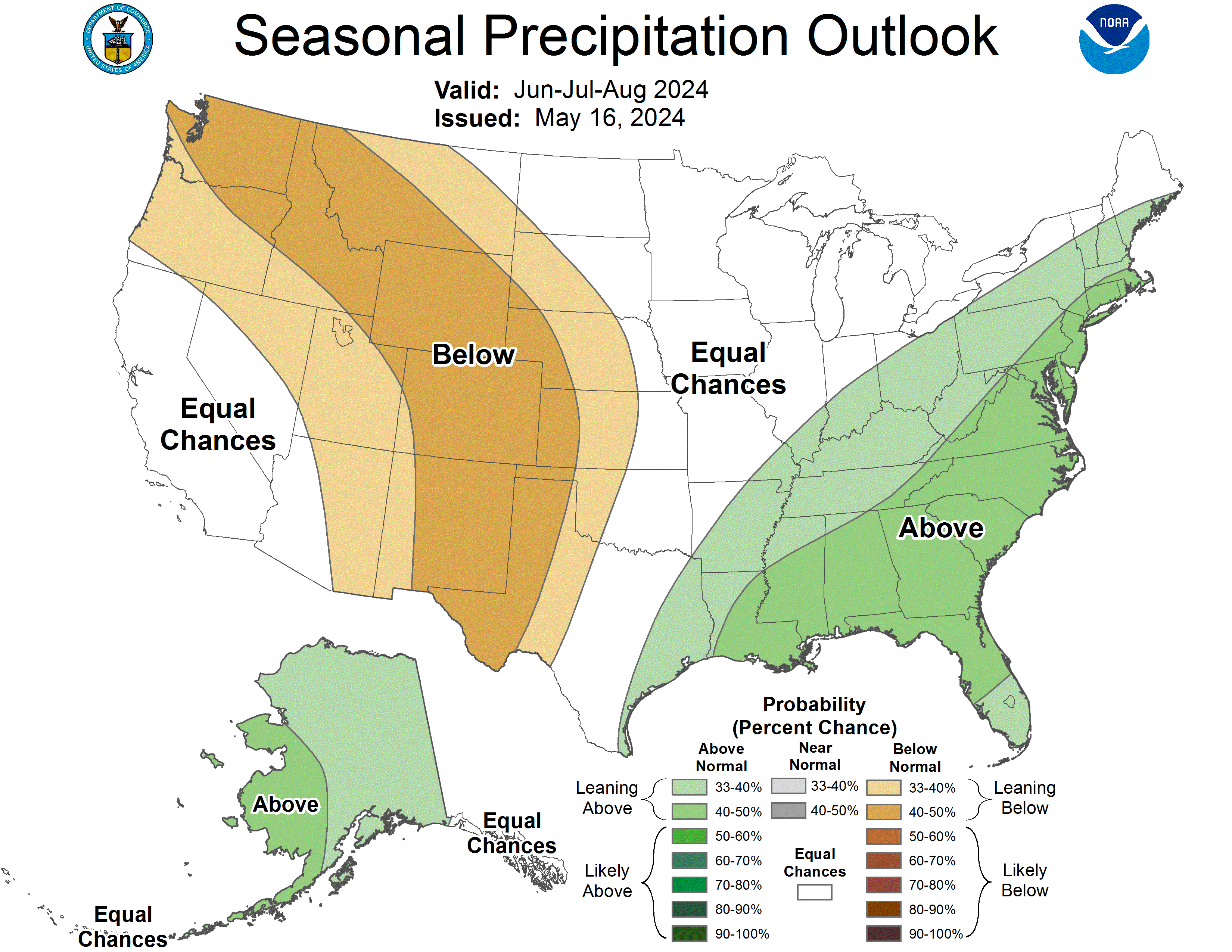
Below is the Climate Prediction Center's (CPC) temperature and precipitation outlook for the Summer of 2024 (June, July and August) which leans to above normal temperatures and below normal precipitation across south central and southeast Colorado.
 |
 |

