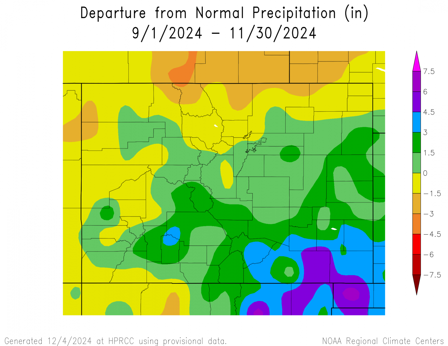
September followed the last few months of summer, in which a meandering ridge of high pressure across the Rockies brought periods of very warm temperatures, as well as, allowing for a few passing weather systems and fronts to bring brief cool downs and rain and higher mountain snow across the region. Very warm temperatures were experienced across south central and southeast Colorado through the month of October, as upper level ridging dominated the weather through much of the month. However, one slow moving weather system through the middle of October brought abundant rain and higher elevation snow to the southern mountains and southern tier of Colorado. November brought much colder temperatures and well above normal precipitation to all of south central and southeast Colorado. The precipitation was bolstered by a slow moving storm system which produced widespread 1 to 3 inches, locally up to 5 inches, of rain and snow water equivalent, as well as snowfall of 2 to 6 feet across portions of southern Colorado from November 4th through 9th.
The following graphics depict seasonal temperature and precipitation departures from normal across the state for the Fall of 2024.
.png) |
 |
The preliminary average temperature for the Fall of 2024 in Alamosa was 44.9 degrees. This is 1.6 degrees above normal and makes the Fall of 2024 the 13th warmest on record in Alamosa. This remains well behind the warmest Fall of 1933, when the average Fall temperature was 46.9F. Alamosa recorded 3.07 inches of precipitation through the Fall of 2024. This is 1.07 inches above normal and makes the Fall of 2024 the 11h wettest fall on record in Alamosa. This remains well behind the wettest fall of 2013 when 5.14 inches of precipitation was recorded. Alamosa recorded 9.4 inches of snow (9.1 inches in November) through the Fall of 2024. This is 3.3 inches above normal and makes the Fall of 2024 the 18th snowiest fall on record. This is well behind the snowiest Fall of 1972, when 34.1 inches of snow was recorded in Alamosa. (ALS POR: 1932-2024)
(click here for a more detailed Fall of 2024 Climate Summary in Alamosa)
The preliminary average temperature for the Fall of 2024 in Colorado Springs was 53.7F. This is 2.6 degrees above normal and makes the Fall of 2024 the 6th warmest fall on record in Colorado Springs. This remains well below the warmest Fall of 2016, when the average fall temperature was 56.0 degrees. Colorado Springs recorded 3.33 inches of precipitation through the Fall of 2024. This is 0.84 inches above normal and makes the Fall of 2024, tied with the Fall of 1961, as the 18th wettest fall on record in Colorado Springs. This remains well behind of the wettest fall of 1909, when 7.50 inches of precipitation was recorded in Colorado Springs. Colorado Springs recorded 22.8 inches of snow (21.6 inches in November) through the Fall of 2024. This is 15.7 inches above normal and makes the Fall of 2024 the 7th snowiest fall on record. This is well behind the snowiest Fall of 1959, when 37.7 inches of snow fell in Colorado Springs. (COS POR: 1894-2024)
(click here for a more detailed Fall of 2024 Climate Summary in Colorado Springs)
The preliminary average temperature for the Fall of 2024 in Pueblo was 55.6F. This is 2.3 degrees above normal and makes the Fall of 2024 tied with the Falls of 1953 and 1910, as the 10th warmest fall on record in Pueblo. This remains well below the warmest Fall of 2016, when the average fall temperature was 58.3F. Pueblo recorded 3.49 inches of precipitation throughout the fall. This is 1.61 inches above normal and makes the Fall of 2024 the 14th wettest fall on record in Pueblo. This remains well behind the wettest Fall of 1957, when 7.74 inches of precipitation was recorded in Pueblo. Pueblo recorded 13.1 inches of snow (13.1 inches in November) through the Fall of 2024. This is 6.9 inches above normal and makes the Fall of 2024 the 13th snowiest fall on record. This is well behind the snowiest Fall of 1991, when 41.9 inches of snow was recorded in Pueblo. (PUB POR: 1888-2024)
(click here for a more detailed Fall of 2024 Climate Summary in Pueblo)
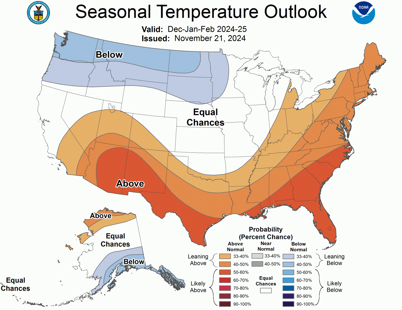
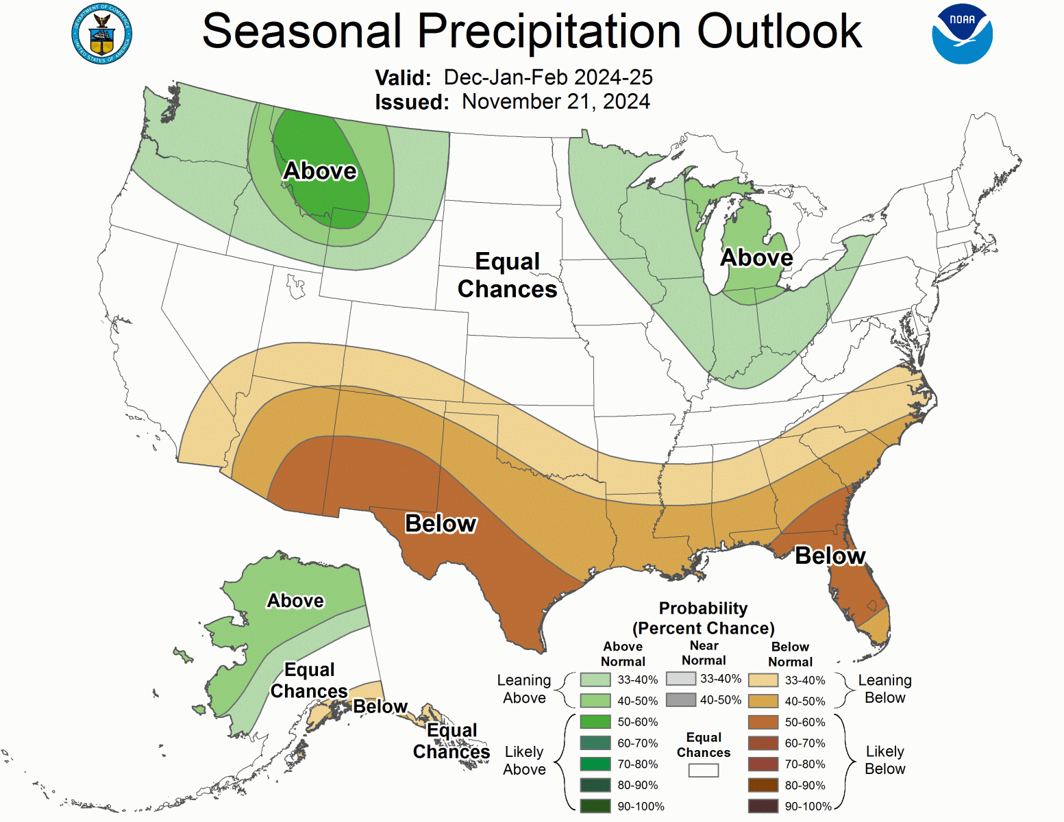
Below is the Climate Prediction Center's (CPC) temperature and precipitation outlook for the Winter of 2024-2025 (December, January and February) which leans to above equal chances of above, below and normal temperatures precipitation across south central and southeast Colorado, save for a slight lean to warmer and drier conditions across the southern Tier of Colorado.
 |
 |