The first week of the January 2023 was relatively cool and unsettled across south central and southeast Colorado, before upper level ridging brought warm and dry conditions to region for the second week of January. The last half of January saw occasional disturbances bringing surges of cold and unsettled weather to the area, with a bout of Arctic air across the southeast Plains at the end of the month. February started off warm and dry across south central and southeast Colorado, with several passing weather systems through out the rest of the month bringing periods of cool and wet weather, as well as another surge of very cold Arctic air across region.
March saw a predominately strong westerly flow pattern across the Rockies, which brought ample moisture and snowfall to areas along and west of the Continental Divide, as well as generally cool, dry and windy weather to most of eastern Colorado. April saw a rollercoaster of temperatures, as passing weather systems brought periods of warm and cold temperatures and generally dry conditions through the first half of the month. A stronger storm system moved across the region through the last week of April, bringing widespread beneficial precipitation to portions of the drought stricken southeast Colorado Plains. May started out warm and dry across south central and southeast Colorado, before a slow moving weather system brought much cooler and abundant precipitation to the area from May 10th through May 12th, with wet heavy snowfall across portions of the southeast mountains and heavy rainfall to portions of the southeast Plains. On May 11th, Colorado Springs recorded 3.18 inches of precipitation, which set a new daily rainfall record for May 11th, as well as a new daily maximum precipitation record for the month of May. A relatively cool and wet weather pattern continued across the region through the end of the month, especially across southeast Colorado.
June was a cool and wet month, especially across southeast Colorado, where several storm systems brought record precipitation amounts for the month as a whole. Colorado Springs recorded 9.62 inches of precipitation through the month of June, which not only set a record for the most precipitation in the month of June, but also becomes the wettest month ever in Colorado Springs, surpassing the 8.13 inches recorded in May of 2015. July was "A Tale of of Two Cities" across southern Colorado, with dry and warm conditions prevailing across south central Colorado, while cooler and unsettled weather prevailed across southeastern Colorado. Alamosa received 0.01 inches of precipitation through out the month July, making July of 2023 the driest July on record in Alamosa, while Campo and Walsh Colorado received 6.33 inches and 6.39 inches respectively, in July, becoming the 5th and 4th wettest July's respectively. Unfortunately, the unsettled weather across the southeast plains also brought bouts of severe weather, with large hail of 2 to 4 inches in diameter, flash flooding, strong damaging wind gusts and tornadoes all observed across southeast Colorado through out the month of July. August was a generally warm and dry month across the region, with upper level ridging parked across the southern High Plains through the Desert Southwest and Great Basin through the first half of the month, keeping monsoonal moisture south and west of the Rockies. This anomalous weather pattern kept eastern Colorado in northwest flow with continued bouts of severe weather, including August 5th, when several funnel clouds where reported across El Paso county. The upper ridge broke down through the end of the month, bringing a few bouts of monsoonal moisture and locally heavy rainfall to portions of south central and southeast Colorado.
September started and ended warm and dry across south central and southeast Colorado, with a passing, unseasonably strong weather system, bringing cool temperatures, good moisture and some accumulating snow to the higher mountain peaks through the middle of the month. A few weather systems moved across the region through the month of October, with the first system bringing showers and thunderstorms and good rainfall for southern portions of the region, as well as some snowfall to the higher mountain peaks through the first week of October, The second system moved across through the middle of the month, bringing some mountain snowfall, as well as a brief cool down across the region. In between these systems, very warm temperatures were experienced across the region, until a much colder weather system moved across the state October 28th and 29th. This system brought abundant snowfall to areas over and near the higher terrain, along with well below seasonal temperatures to the region. A few weather systems moved across the region through the second and third week of November, bringing some precipitation to mainly areas over and near the higher terrain, as well as cooler temperatures areawide. In between these systems, warm and dry conditions were experienced across the region helping, to make November of 2023 warmer and drier than normal for the month as a whole. Upper level ridging, in place across the Rockies through a majority of December, would give way for a few Pacific weather systems to move the region. These passing systems brought beneficial moisture in the form of snow and rain to the region, along with only brief cool downs in temperatures.
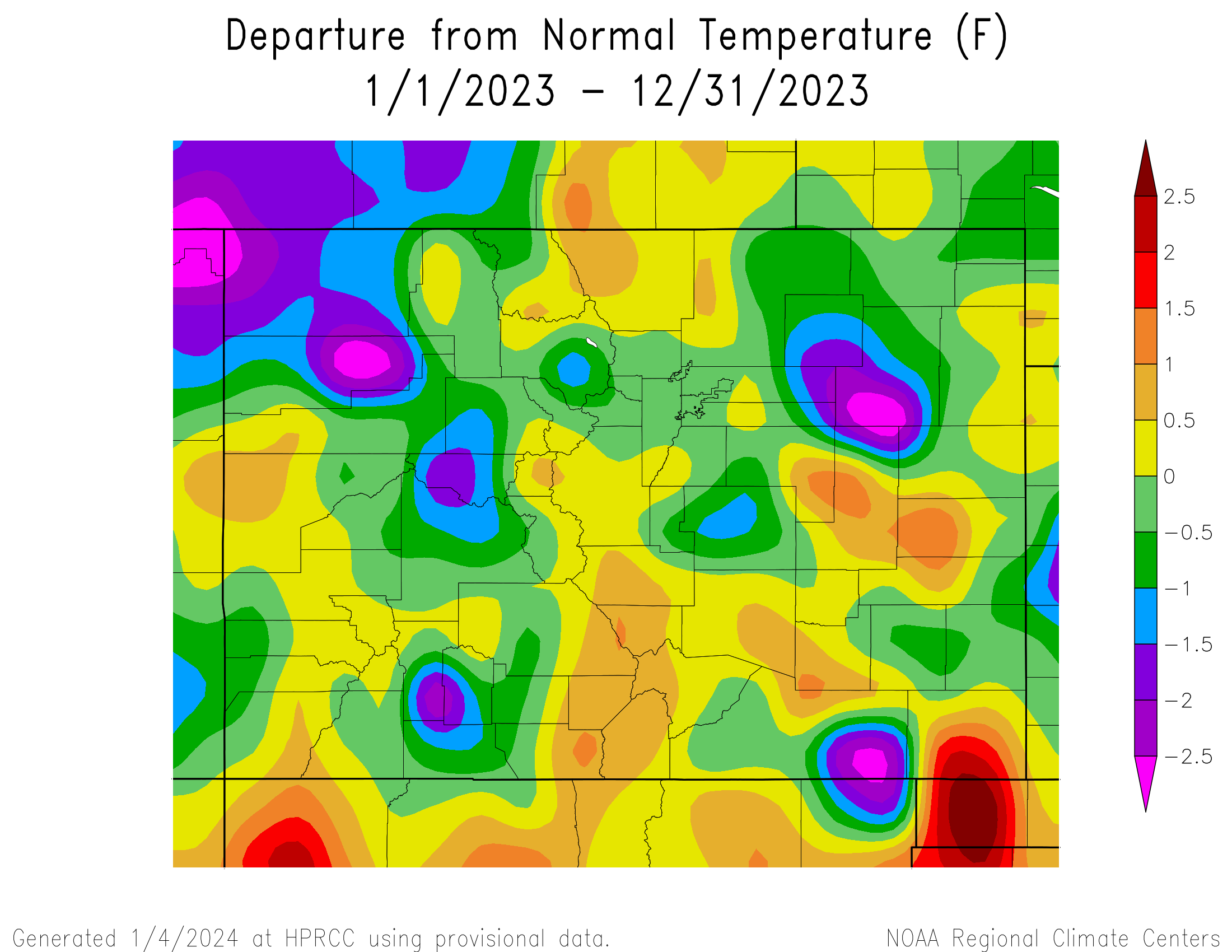
The following graphics depict preliminary departures from normal for both temperature and precipitation for 2023 across Colorado.
 |
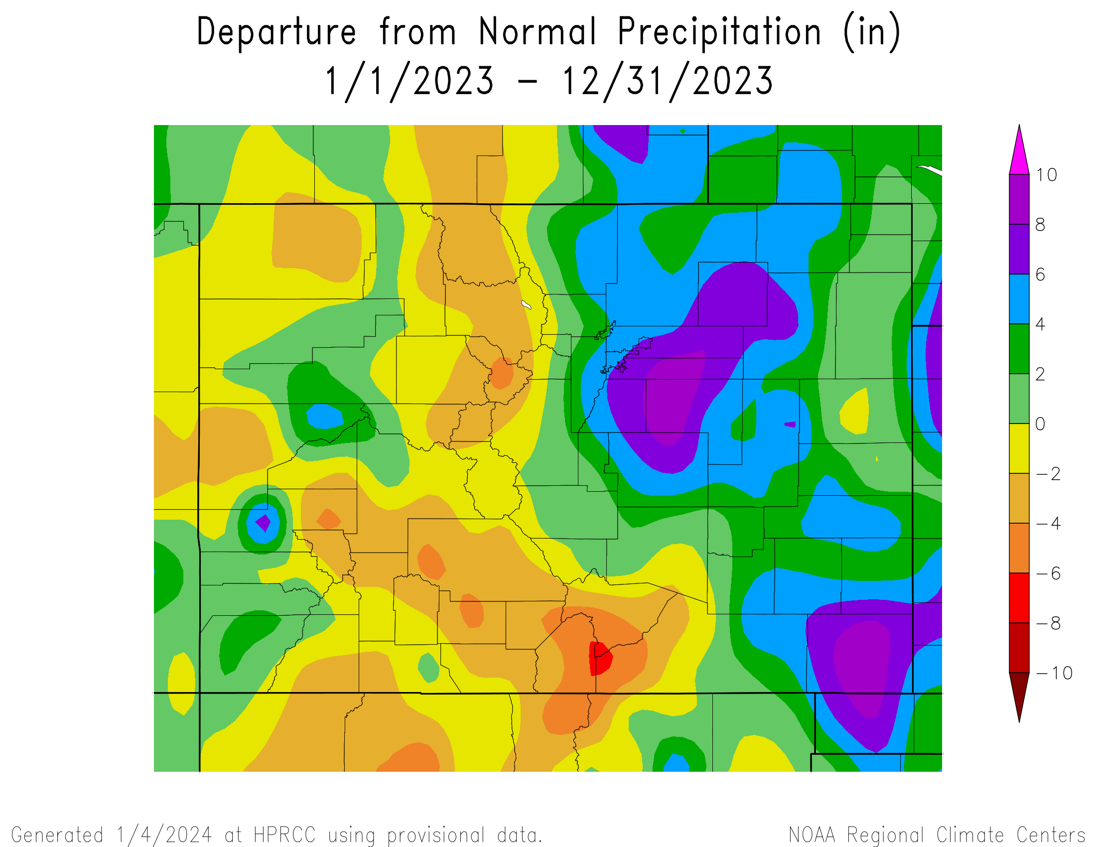 |
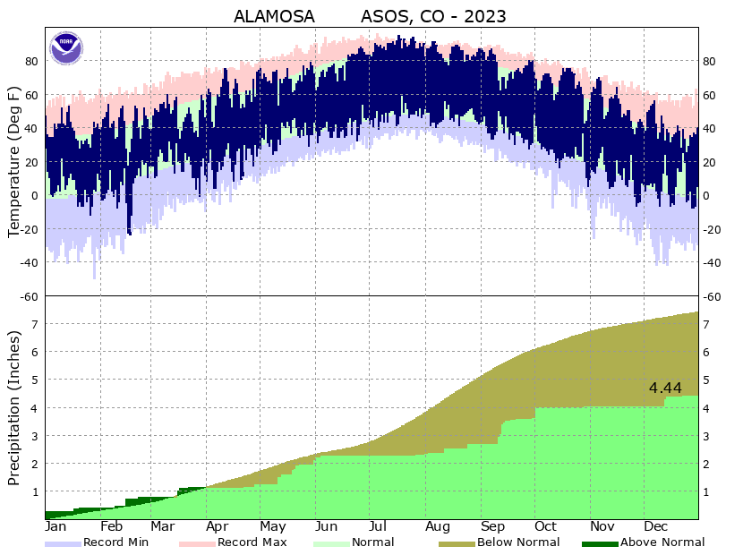
The 2023 average temperature in Alamosa was 43.2 degrees. This is 0.9 degrees above normal and makes 2023 the 12th warmest year on record in Alamosa. Alamosa recorded 4.44 inches of precipitation in 2023. This is 2.97 inches below normal and makes 2023 the 9th driest year on record in Alamosa. Alamosa tallied 21.8 inches of snow in 2023. This is 6.1 inches below normal and makes 2023 the 25th least snowiest year on record. A more detailed 2023 climate summary for Alamosa can be found at:
2023 Alamosa Annual Climate Summary
 |
The 2023 average temperature in Colorado Springs was 51.2 degrees. This is 0.8 degrees above normal and makes 2023 tied as 11th warmest year on record in Colorado Springs. Colorado Springs recorded 25.47 inches of precipitation in 2023. This is 9.56 inches above normal and makes 2023 the 2nd wettest year on record in Colorado Springs, just behind the 27.58 inches recorded in 1999. Colorado Springs tallied 42.5 inches of snow in 2023. This is 10.0 inches above normal and makes 2023 the 30th snowiest year on record. A more detailed 2023 climate summary for Colorado Springs can be found at:
2023 Colorado Springs Annual Climate Summary
 |
The 2023 average temperature in Pueblo was 53.7 degrees. This is 0.5 degrees above normal and makes 2023 tied as the 21st warmest year on record. Pueblo recorded 13.42 inches of precipitation in 2023. This is 1.44 inches above normal and makes 2023 the 40th wettest year on record in Pueblo. Pueblo tallied 24.6 inches of snow in 2023. This is 3.7 inches below normal and makes 2023 the 51st least snowiest year on record. A more detailed 2023 climate summary for Pueblo can be found at:
2023 Pueblo Annual Climate Summary
 |
***Period of Record (POR)***
Alamosa: 1932-present
Colorado Springs: 1894-present
Pueblo: 1889-present

