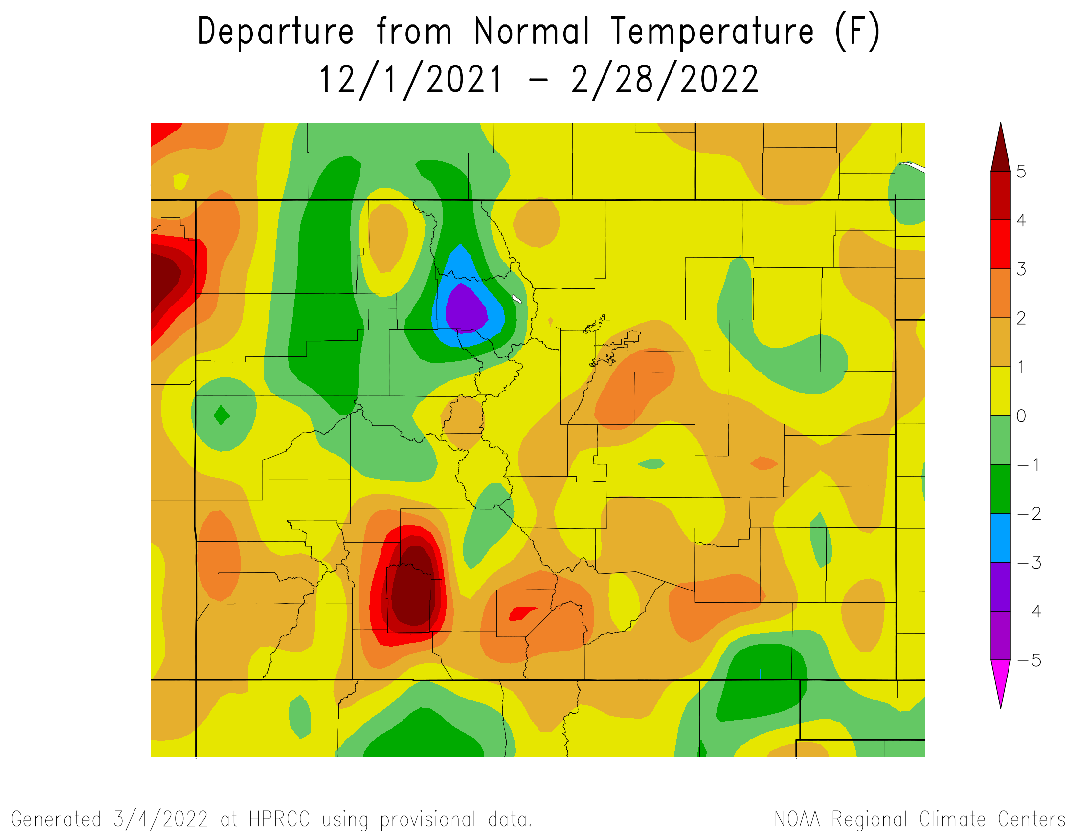
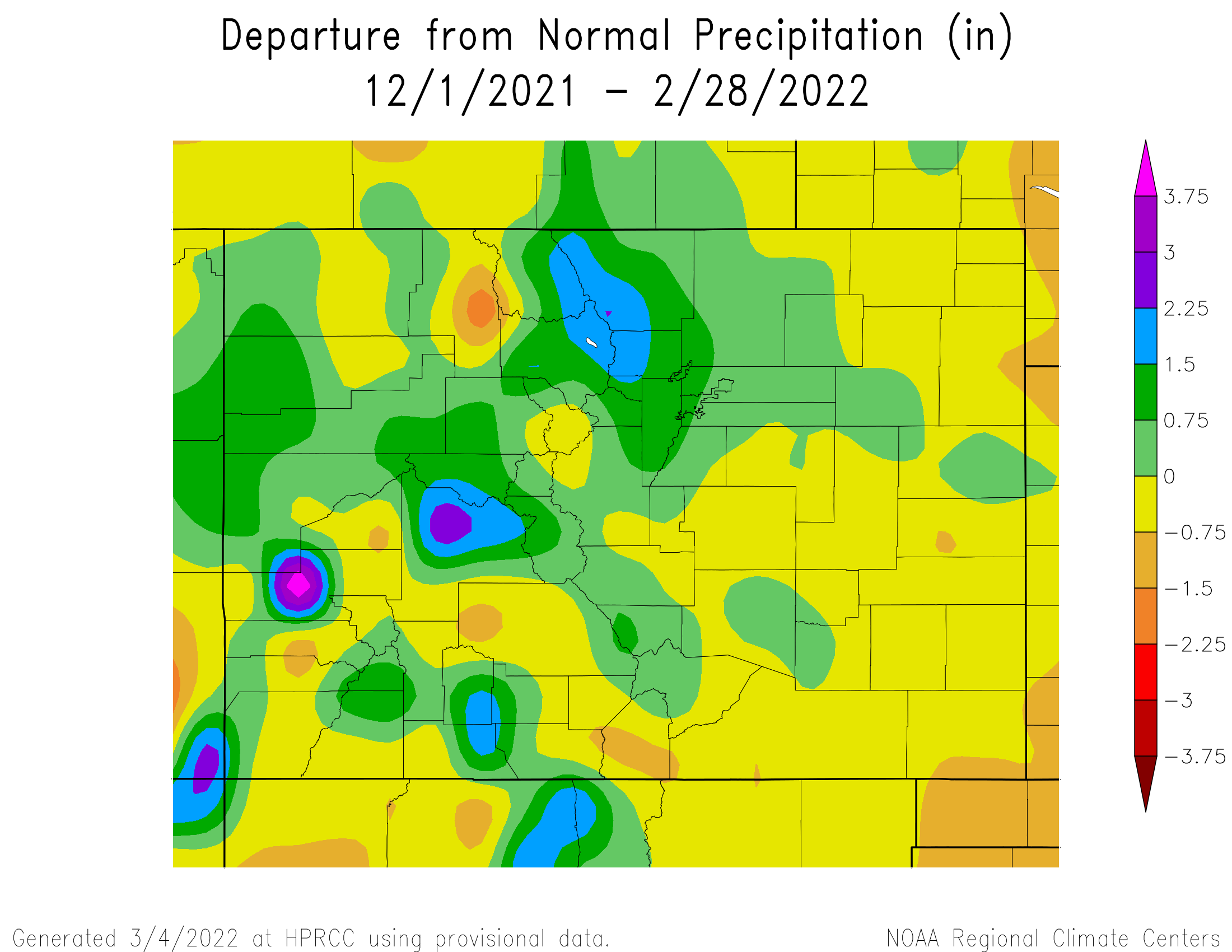
The winter of 2021-2022 (December through February) started very warm with new record high temperatures being set across south central and southeast Colorado in the first few days of the December. A few strong weather systems moved across the Rockies through the middle and end of December, bringing abundant snowfall to the higher terrain along and west of the Continental Divide, especially across the southwest mountains where several feet of much needed snowfall was recorded through out the month of December. Unfortunately, these weather systems did not bring much, if any precipitation, to the drought stricken southeast plains, where strong winds and very warm temperatures through out the month only exacerbated the drought. This is especially true for the weather system moving across the state on December 15th, which brought widespread damaging winds of 80 to 100 mph to southeast Colorado (strongest recorded gust in KLAA of 107 mph) causing widespread tree and powerline damage across the I-25 Corridor through the far southeast plains. January started out cold and snowy across south central and southeast Colorado, as a passing storm system brought the first snow of the year across portions of south central and southeast Colorado on New Years Day. Upper level ridging building in behind the New Years storm system brought warmer and drier conditions for the next few days of January. An up and down weather pattern was then experienced across the region, as several weather systems moved across the state through the rest of January. February again started out cold and snowy across south central and southeast Colorado, as an unseasonal cold weather system ushered in some of the coldest air of the winter season. Temperatures and precipitation across the region ebbed and flowed as several more weather systems moved across the Rockies through the middle of February, bringing bouts of snowy and cold weather to much of south central and southeast Colorado, before upper level ridging brought in much warmer and drier weather to the state for the last few days of the month.
The following graphics depict seasonal temperature and precipitation departures from normal across the state for the Winter of 2021-2022.
 |
 |
The preliminary average temperature for the Winter of 2021-2022 in Alamosa was 21.9 degrees. This is 2.1 degrees above normal and makes the Winter of 2021-2022 the 28th warmest Winter on record in Alamosa. This remains well behind the warmest Winter of 1994-1995, when the average winter temperature was 26.4 degrees. Alamosa recorded 0.73 inches of precipitation through the winter season, which is 0.22 inches below normal. Alamosa also recorded 11.8 inches of snow through the winter of 2021-2022.
(click here for a more detailed Winter of 2021-2022 Climate Summary in Alamosa)
The preliminary average temperature for the Winter of 2021-2022 in Colorado Springs was 34.4 degrees. This is 2.2 degrees above normal and makes the Winter of 2021-2022 tied with the Winter of 1975-76 as the 9th warmest on record in Colorado Springs. This remains well behind the warmest Winter Season of 1933-34, when the average winter temperature was 37.6 degrees. Colorado Springs recorded 0.85 inches of precipitation and 15.2 inches of snow through the winter season. This is 0.01 inches above normal and 1.6 inches above normal respectively, and makes the Winter of 2021-2022 the 62nd wettest and the 45th snowiest winter on record in Colorado Springs.
(click here for a more detailed Winter of 2021-2022 Climate Summary in Colorado Springs)
The preliminary average temperature for the Winter of 2021-2022 in Pueblo was 38.8 degrees. This is 0.9 degrees above normal and makes the Winter of 2021-2022 tied with the Winters of 1965-65 and 2019-20 as the 40th warmest on record in Pueblo. This remains well behind the warmest Winter of 1933-34, when the average winter temperature was 39.6 degrees. Pueblo recorded 1.23 inches of precipitation and 13.7 inches of snow through the Winter of 2021-2022. This is 0.33 inches above normal and 0.5 inches below normal respectively, and makes the Winter of 2021-2022 the 48th wettest and 56th least snowy winter season on record in Pueblo.
(click here for a more detailed Winter of 2021-2022 Climate Summary in Pueblo)
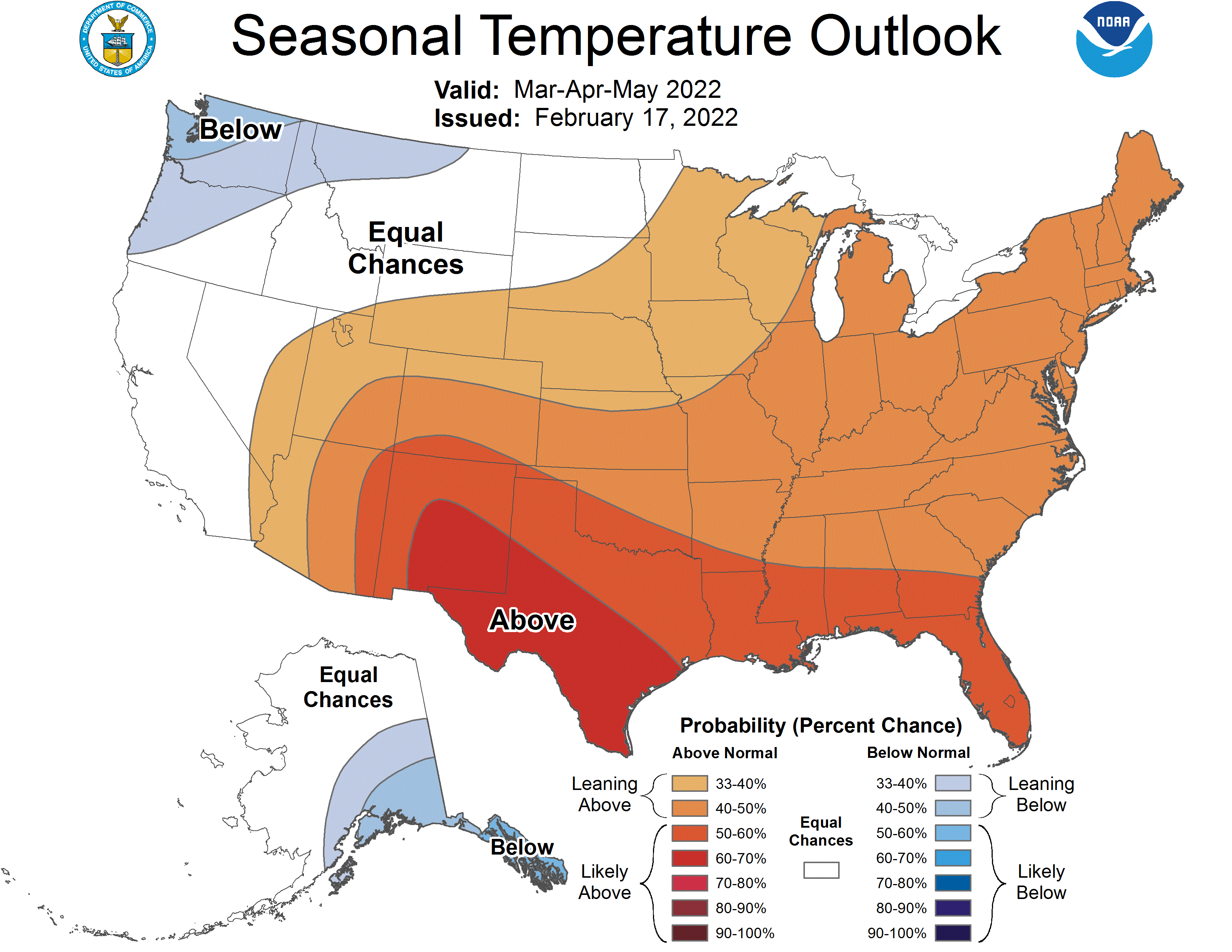
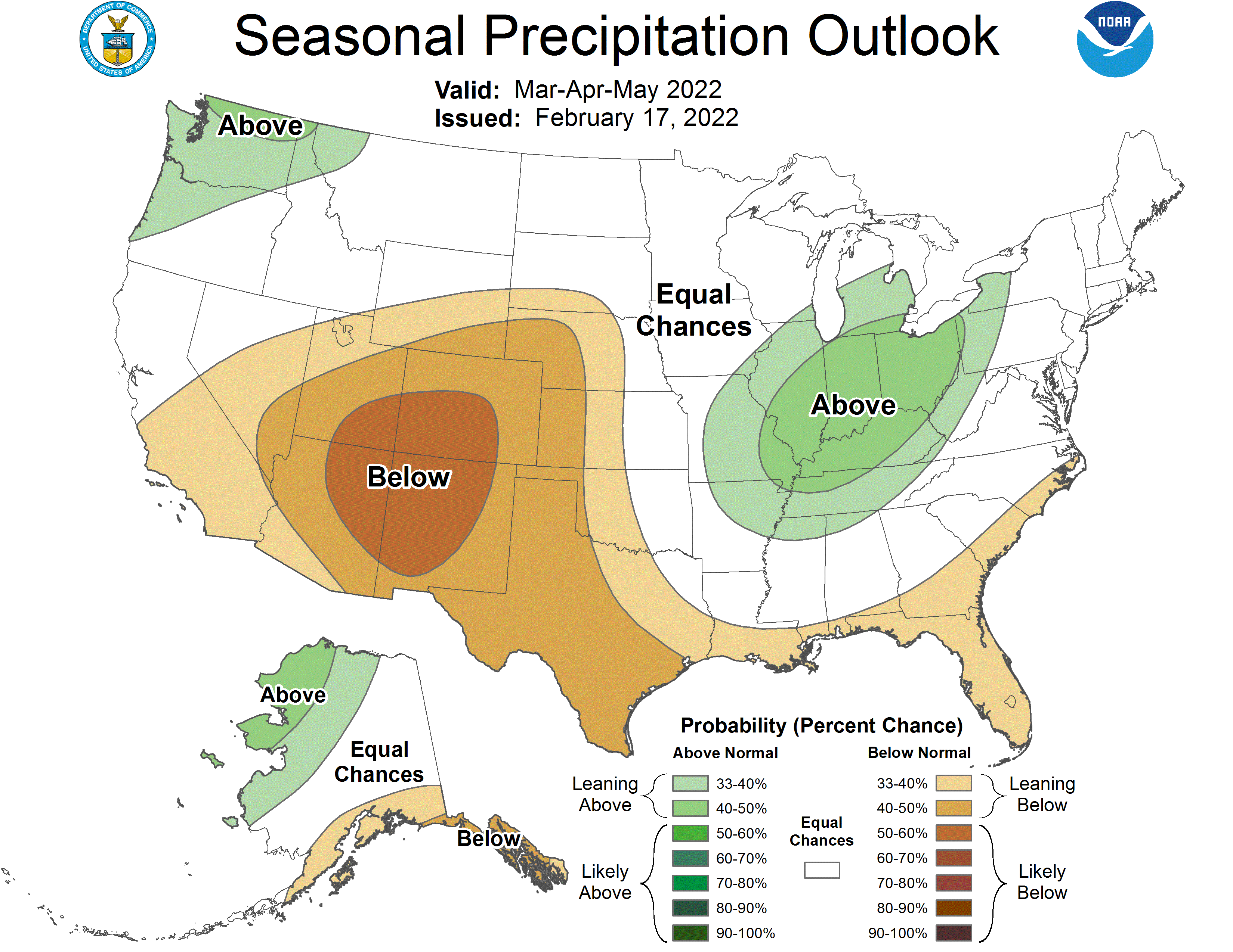
Below is the Climate Prediction Center's (CPC) temperature and precipitation outlook for the Spring of 2022 (March, April and May) which indicates better chances of above normal temperatures and below normal precipitation across south central and southeast Colorado.
 |
 |

