January started out cold and snowy across south central and southeast Colorado, as a passing storm system brought the first snow of the year across portions of south central and southeast Colorado on New Years Day. Upper level ridging building in behind the New Years storm system brought warmer and drier conditions for the next few days of January. An up and down weather pattern was then experienced across the region, as several weather systems moved across the state through the rest of January. February again started out cold and snowy across south central and southeast Colorado, as an unseasonal cold weather system ushered in some of the coldest air of the winter season. Temperatures and precipitation across the region ebbed and flowed as several more weather systems moved across the Rockies through the middle of February, bringing bouts of snowy and cold weather to much of south central and southeast Colorado, before upper level ridging brought in much warmer and drier weather to the state for the last few days of the month.
March started out and ended warm and dry, with periods of cold and wet weather the rule through out the rest of March, as several weather systems brought cool and unsettled weather to south central and southeast Colorado. Occasional breezy to windy conditions also brought periods of critical fire weather conditions to portions of south central and southeast Colorado through out the month of March. April was a warm, windy and dry month across south central and especially southeast Colorado, as weather systems moved mainly north of area, bringing very windy and mainly dry weather to southern Colorado. This dry and very windy pattern brought critical and extreme fire weather conditions to much of south central and southeast Colorado through out the month, with several wildfires and dust storms recorded across the region in April. May was a bi-polar month, especially across southeast Colorado, where very warm and windy weather through the 1st half of the month brought very critical fire weather conditions across the region, along with several new wildfires. Warm and windy conditions prevailed across southeast Colorado through May 20th, when an unseasonably strong weather system brought 10 to 30 inches of late season snowfall to Pikes Peak region and areas along and west of the I-25 Corridor.
June saw a rollercoaster of temperatures and precipitation across south central and southeast Colorado, as several passing weather systems brought bouts of cold and stormy conditions, along with bouts of warm and dry conditions. The later half of June also saw an early start to the monsoon season, especially across southwestern and into south central Colorado, where above normal precipitation was experienced for the month as a whole. July was a warm and relatively wet month across south central and southeast Colorado, as the southwest summer monsoon brought in periods of abundant moisture and bouts of heavy rainfall across the region. The southwest monsoon remained active through out the month of August, especially for areas over and near the higher terrain, with periods of abundant moisture and bouts of heavy rainfall across the region.
September saw predominate west to southwest flow aloft across the region through the month. This kept generally warm temperatures in place across south central and southeast Colorado, with a few passing systems bringing a few days of cooler temperatures, especially across the eastern plains, with upslope flow behind passing fronts. The southwesterly flow aloft also brought in some monsoonal moisture, especially in the September 20th through September 22nd timeframe, when ample subtropical moisture brought locally heavy rainfall to areas along and west of the Continental Divide. A mainly west to northwest flow pattern through the first half of October brought a few bouts of precipitation, especially across the northern and central mountains, as well as brief bouts of cooler temperatures to the region, as a few passing weather systems moved mainly north of the region. A pattern shift occurred through the last half of October, where as a few weather systems moved just south of the area, owning to better precipitation across the southern mountains and bouts of breezy to windy conditions across the southeast plains. An up and down weather pattern was experienced across the region through the first half of November, as a few passing weather systems brought periods of of cool and unsettled weather along with periods of warm and dry conditions. A pattern shift developed through the second half of the month, where as, a broad upper trough carved out across the central CONUS, bringing surges of Arctic air into the Rockies. The first half of December was relatively warm and dry across south central and southeast Colorado. The second half of the month saw occasional disturbances bringing surges of cold and unsettled weather to the area, especially eastern Colorado, which saw a true "Arctic Intrusion" leading up to the Christmas Holiday Weekend.
The following graphics depict preliminary departures from normal for both temperature and precipitation for 2022 across Colorado.
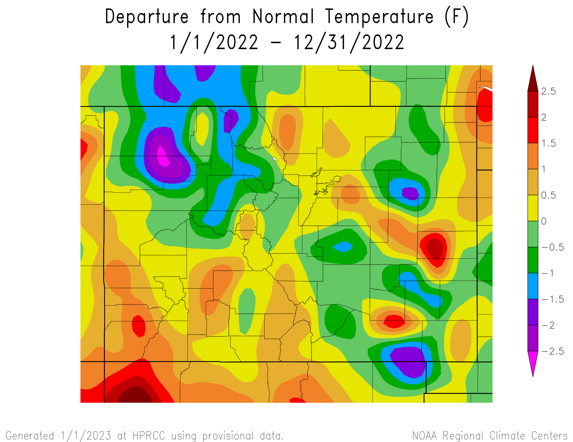 |
 |
The 2022 average temperature in Alamosa was 43.0 degrees. This is 0.7 degrees above normal and makes 2022 tied with 1958, 2006, and 2016 as the 16th warmest year on record in Alamosa. Alamosa recorded 9.97 inches of precipitation through 2022. This is 2.58 inches above normal and makes 2022 the 9th wettest year on record in Alamosa. Alamosa tallied 23.6 inches of snow in 2022. A more detailed 2022 climate summary for Alamosa can be found at:
2022 Alamosa Annual Climate Summary
 |
The 2022 average temperature in Colorado Springs was 51.3 degrees. This is 0.9 degrees above normal and makes 2022 tied with 1981 as the 9th warmest year on record in Colorado Springs. Colorado Springs recorded 13.49 inches of precipitation through 2022. This is 2.42 inches below normal and makes 2022 the 49th driest year on record in Colorado Springs. Colorado Springs tallied 44.3 inches of snow through out 2022, which is 11.8 inches above normal. A more detailed 2022 climate summary for Colorado Springs can be found at:
2022 Colorado Springs Annual Climate Summary
 |
The 2022 average temperature in Pueblo was 53.2 degrees, which is normal. Pueblo recorded 9.39 inches of precipitation through 2022. This is 2.63 inches below normal and makes 2022 the 33th driest year on record in Pueblo. Pueblo tallied 30.1 inches of snow through 2022, which is 1.8 inches above normal. A more detailed 2022 climate summary for Pueblo can be found at:
2022 Pueblo Annual Climate Summary
 |

