The start of "Meteorological Spring of 2019" (March, April and May) was a cool and wet across most of south Central and southeast Colorado, as periodic weather disturbances moved across the Rockies, bringing abundant snowfall to areas over and near the higher terrain, especially along and west of the Continental Divide. This snowfall produced an unprecedented amount of avalanches across Colorado's "High Country" throughout the month of March. This pattern also produced an extremely powerful low pressure system across southern Colorado on March 13th, bringing strong and damaging winds and widespread rain to the southeast Plains, blizzard conditions over El Paso County, and dropping feet of snow over the mountains. The "bombogenesis" event of March 13th also set records as it produced the lowest surface pressure ever recorded (970.4 mb in Lamar) in the state, along with several records of the strongest wind gusts across southeast Colorado, including a record setting 96 mph wind gust at the Colorado Springs Airport.
April of 2019 was roller coaster month for temperatures, especially across the southeast Plains, as weather systems moving across the Rockies brought periods of unseasonably warm weather followed by periods of unseasonably cool weather to the region. These systems also brought bouts of rain and snow, especially for areas over and near the higher terrain. May of 2019 continued to be a roller coaster month for weather across the state, with a few spells of warm and dry weather, along with periods of unseasonably cold and strong weather systems bringing abundant rain and snow across the area, as well as bouts of severe weather across the southeast Plains.
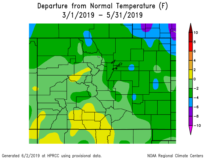
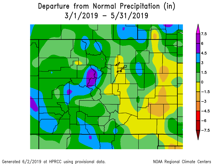
For the Spring of 2019 as a whole, near normal to below normal temperatures were experienced across south central and southeast Colorado. As for precipitation, generally above normal precipitation was experienced across the area, save for pockets of at and below normal precipitation across the southeast Plains.
The following graphics indicate seasonal temperature and precipitation departures from normal across the state throughout the Spring of 2019.
 |
 |
The preliminary average temperature for the Spring of 2019 in Alamosa was 42.7 degrees, which is 0.5 degrees above normal. Alamosa recorded 3.15 inches of precipitation throughout the Spring. This is 1.45 inches above normal and makes the Spring of 2019 the 8th wettest Spring on record. This remains behind the wettest Spring on record, 1942, when 3.74 inches of precipitation fell in Alamosa. Alamosa recorded 17.9 inches of snow throughout the Spring. This is 8.4 inches above normal and makes the Spring of 2019 the 9th snowiest Spring on record. This remains well behind the snowiest Spring on record, 1973, when 48.3 inches of snow fell in Alamosa. This brings the 2018-2019 seasonal snowfall tally in Alamosa to 54.9 inches. This is 27.3 inches above normal and makes the 2018-2019 snowfall season the 5th snowiest on record in Alamosa. This, however, remains well behind the snowiest season, 1972-73, when 97.5 inches of snow was recorded in Alamosa.
(click here for a more detailed Spring of 2019 Climate Summary for Alamosa)
The preliminary average temperature for the Spring of 2019 in Colorado Springs was 46.0 degrees, which is 1.2 degrees below normal. Colorado Springs recorded 4.75 inches of precipitation throughout the Spring, which is 0.30 inches above normal. Colorado Springs recorded 17.9 inches of snow throughout the Spring, which is 4.2 inches above normal. This brings the 2018-2019 seasonal snowfall tally in Colorado Springs to 36.2 inches, which is 1.5 inches below normal.
(click here for a more detailed Spring of 2019 Climate Summary in Colorado Springs)
The preliminary average temperature for the Spring of 2019 in Pueblo was 50.5 degrees, which is 0.6 degrees below normal. Pueblo recorded 3.59 inches of precipitation throughout the Spring, which is 0.25 inches below normal. Pueblo recorded 2.2 inches of snow throughout the Spring, which is 7.8 inches below normal. This brings the 2018-2019 seasonal snowfall tally in Pueblo to 17.0 inches. This is 14.8 inches below normal and makes the 2018-2019 snowfall season the 12th least snowiest on record in Pueblo. This, however, remains well above the least snowiest season, 1934-35, when only 7.6 inches of snow was recorded in Pueblo.
(click here for a more detailed Spring of 2019 Climate Summary in Pueblo)
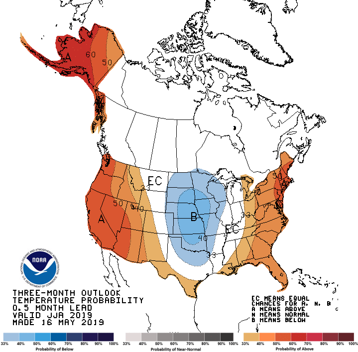
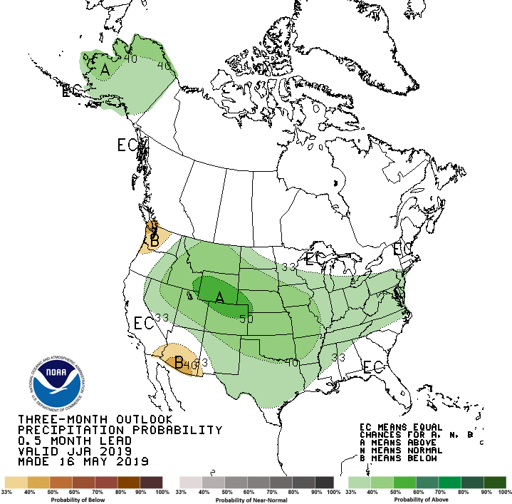
Below is the Climate Prediction Center's (CPC) temperature and precipitation outlook for the Summer of 2019 (June, July and August), which indicates equal chances of above, below and near normal temperatures across south central Colorado and a slight nod to below normal temperatures across southeast Colorado. As for precipitation, the outlook indicates better chances for above normal precipitation across all of south central and southeast Colorado throughout the Summer.
 |
 |

