January of 2019 started out cold and unsettled, as a passing weather system ushered in some of the coldest air of the season across the area on New Years Day. The rest of January can be characterized by periodic weather disturbances moving through persistent moderate west to northwest flow aloft across the Rockies. This pattern brought beneficial snowfall to areas over and near the higher terrain, with periods of warm temperatures and strong winds, as well as brief periods of moisture and cold temperatures, to the Southeast Plains. February of 2019 continued the weather pattern of the previous month, with periodic weather disturbances moving through persistent moderate west to northwest flow aloft across the Rockies. This pattern brought abundant and beneficial snowfall to areas over and near the higher terrain, especially the Southwest Mountains, with Wolf Creek Ski resort reporting over 5 feet of snow in one 7 day period. This pattern also brought periods of warm temperatures and strong winds, as well as brief periods of moisture and cold arctic intrusions to the Southeast Plains.
March of 2019 was a cool and wet month across most of South Central and Southeast Colorado. as periodic weather disturbances moved across the Rockies, bringing abundant snowfall to areas over and near the higher terrain, especially along and west of the Continental Divide. This snowfall produced an unprecedented amount of avalanches across Colorado's High County through out the month of March. This pattern also produced an extremely powerful low pressure system across southern Colorado on March 13th, bringing strong and damaging winds and widespread rain to the Southeast Plains, blizzard conditions over El Paso County, and dropping feet of snow over the mountains. The "bombogenesis" event of March 13th also set records as it produced the lowest surface pressure ever recorded (970.4 mb in Lamar) in the state, along with several records of the strongest wind gusts across Southeast Colorado, including a record setting 96 mph wind gust at the Colorado Springs Airport. April of 2019 was roller coaster month for temperatures, especially across the southeast Plains, as weather systems moving across the Rockies brought periods of unseasonably warm weather followed by periods of unseasonably cool weather to the region. These systems also brought bouts of rain and snow, especially for areas over and near the higher terrain. May of 2019 continued to be a roller coaster month for weather across the state, with a few spells of warm and dry weather, along with periods of unseasonably cold and strong weather systems bringing abundant rain and snow across the area, as well as bouts of severe weather across the southeast Plains.
June of 2019 continued to be a roller coaster month for weather across the state, with a few warm and dry spells followed by unseasonably cold and strong weather systems bringing rain, mountain snow and severe storms across the area. Accumulating snowfall was even recorded across the higher peaks on the first full day of Summer, June 22nd. High pressure aloft built into the region bringing an extended period of "summer warmth" for the last week of the month. July of 2019 saw temperatures rise to more "summer" like conditions across most of south central and southeast Colorado. In addition, bouts of "monsoonal moisture" brought some bursts of heavy rainfall, along with a few rounds of severe thunderstorms, across the area through out the month of July. August of 2019 was generally hot and dry across south central and southeast Colorado, as upper level high pressure persisted across the Desert Southwest and Four Corners region, which limited the amount of monsoonal moisture moving into the region.
September of 2019 started off where August left off, hot and mainly dry across south central and southeast Colorado. Colorado Springs set or tied 3 daily record high temperatures through the first 5 days of the month, while Pueblo tied or set 4 daily record highs through the first five days of September! Warm and mainly dry conditions continued through most of the rest of September, as upper level high pressure persisted across the Desert Southwest and Four Corners region. October of 2019 was the polar opposite of September, with several unseasonably strong and cold systems moving across Colorado bringing early season record cold temperatures as well as the seasons first snowfall for many locales. Of note, Pueblo set the coldest temperature ever recorded in October of -6F on October 30th, beating the previous October record low temperature of -4F set on October 29th of 1917! November of 2019 saw a few passing weather systems moving across the state through the fist half of the month, bringing periods of warm and cold temperatures along with some light precipitation across the area. For the last half of the month, several unseasonably strong and cold systems moved across Colorado, bringing abundant snowfall for many locales along with colder than normal temperatures through the end of the month. December of 2019 saw several passing weather systems across the state, bringing periods of cold and snow, along with periods of above to well above seasonal temperatures.
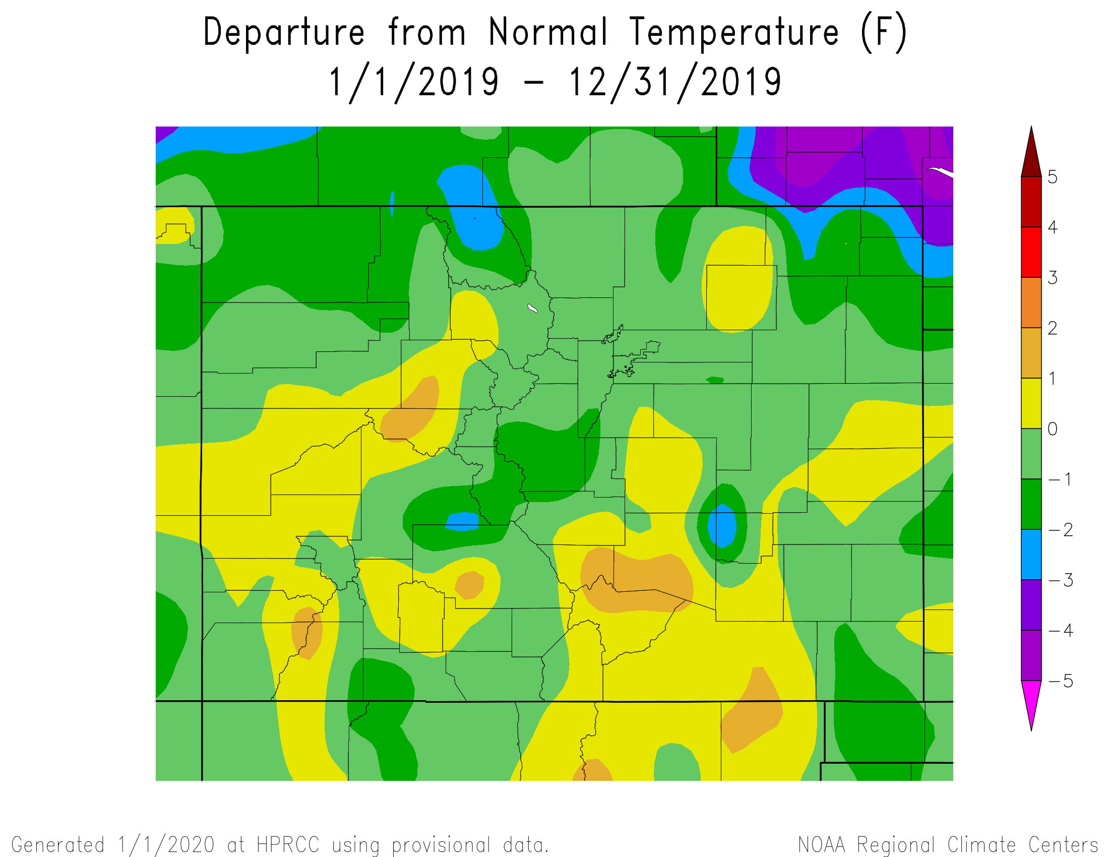
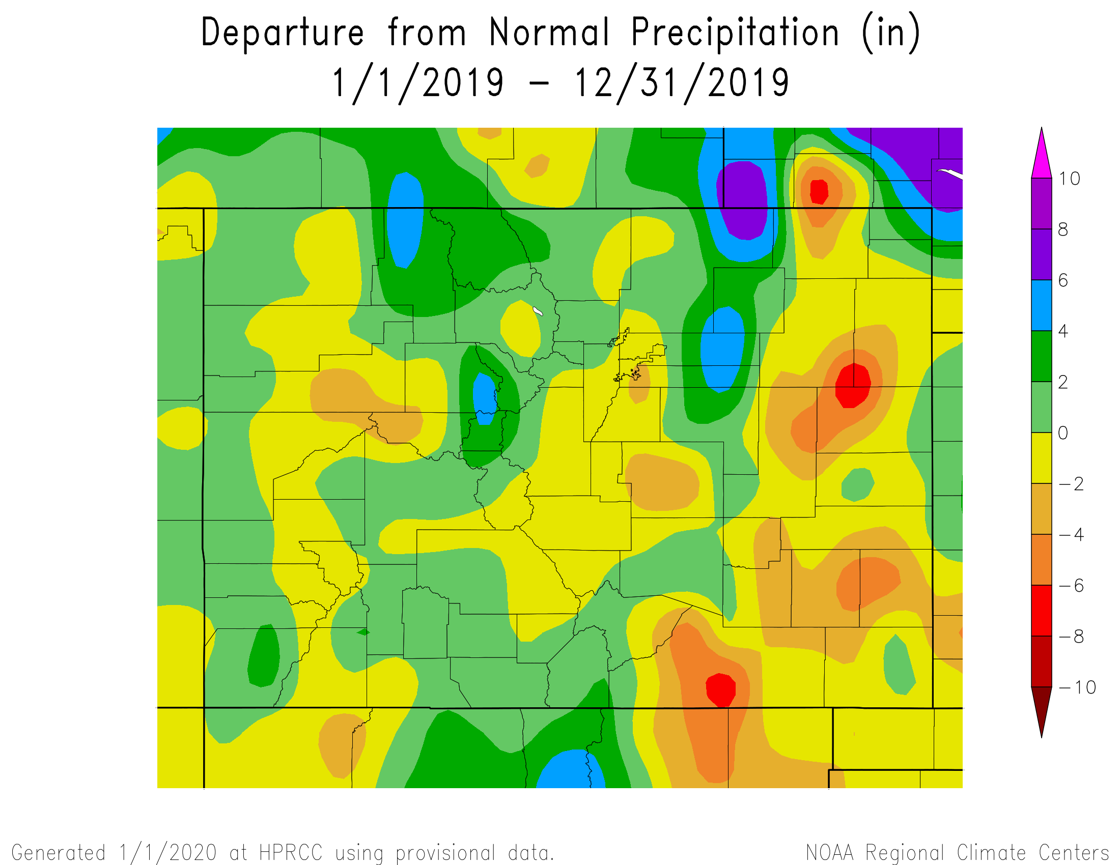
The following graphics depict preliminary departures from normal for both temperature and precipitation for 2019 across Colorado.
 |
 |
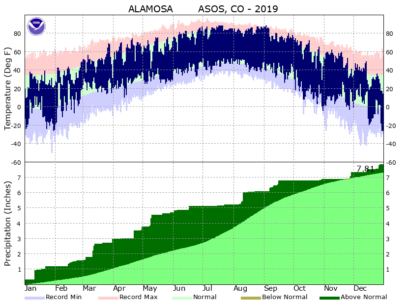
The 2019 average temperature in Alamosa was 40.8 degrees, which is 0.8 degrees below normal. Alamosa recorded 7.81 inches of precipitation through 2019, which is 0.50 inches above normal. Alamosa tallied 53.5 inches of snow in 2019. This is 25.9 inches above normal and makes 2019 the 7th snowiest year on record in Alamosa. A more detailed 2019 climate summary for Alamosa can be found at:
2019 Alamosa Annual Climate Summary
 |
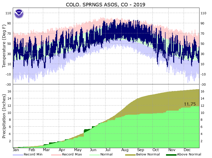
The 2019 average temperature in Colorado Springs was 49.7 degrees, which is 0.7 degrees above normal. Colorado Springs recorded 11.75 inches of precipitation through out 2019. This is 4.79 inches below normal and makes 2019 the 24th driest year on record in Colorado Springs. Colorado Springs tallied 52.3 inches of snow through out 2019. This is 14.6 inches above normal and makes 2019 the 17th snowiest year on record in Colorado Springs. A more detailed 2019 climate summary for Colorado Springs can be found at:
2019 Colorado Springs Annual Climate Summary
 |
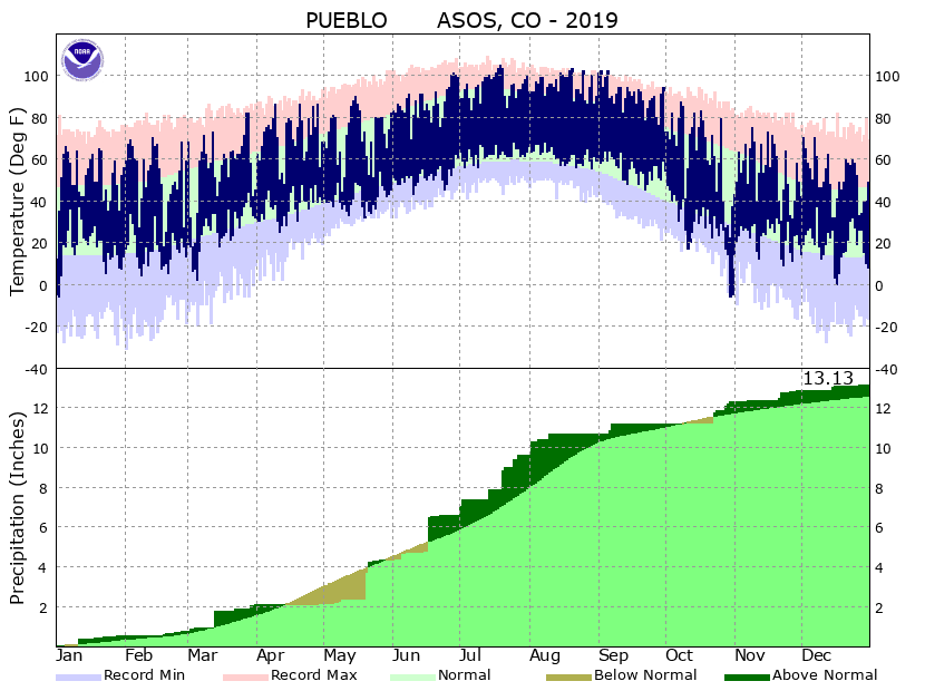
The 2019 average temperature in Pueblo was 53.1 degrees, which is 1.1 degrees above normal. Pueblo recorded 13.13 inches of precipitation through out 2019, which is 0.56 inches above normal. Pueblo tallied 31.3 inches of snow through out 2019, which is 0.5 inches below normal. A more detailed 2019 climate summary for Pueblo can be found at:
2019 Pueblo Annual Climate Summary
 |

