New Year's Day of 2018 started out on the chilly side, especially across southeastern Colorado, however the rest of January of 2018 was mainly warm and dry across much of South Central and Southeast Colorado. A few weather systems and associated cold fronts did move across the region through out the month, bringing a few big temperature swings, especially across the Eastern Plains, along with some generally light snow across the region. There was a pattern change early in February where the persistent upper ridge across the West Coast broke down, and allowed for several Pacific weather systems to move across the state through out the month. The moderate to strong and moist westerly flow aloft helped to bring some much needed precipitation to areas along the Continental Divide, especially for the Southwest Mountains.
March of 2018 came in like a "lamb" across South Central and Southeast Colorado. Unfortunately, March also ended like a "lamb" across the area, with only a few weather systems moving across the region through the rest of the month, bringing some generally light precipitation to the South Central and Southeast Colorado, with better tallies across northern portions of Colorado. Another pattern change with the breakdown of a persistent upper ridge across the West Coast allowed for several weather systems to move across the Rockies through out the month of April, 2018. A few of these weather systems brought beneficial rain and snow to much of South Central and Southeast Colorado, with a few systems also bringing windy and dry conditions to the area, supporting extreme fire danger. One of these days was April 17th, where several destructive wildfires rapidly spread across South Central and Southeast Colorado. A few Spring weather systems brought some beneficial precipitation to the state of Colorado through out the month of May. However, the bulk of this precipitation was focused across northern and northeastern portions of the state, which has been the trend through out the past several months. For the month of May as a whole, above to well above normal temperatures and below to well below normal precipitation was experienced across South Central and Southeast Colorado.
June of 2018 was a very warm and a generally dry month across south central and southeast Colorado. A few weather systems, including the remnants of a tropical system moving north and east out of the Gulf of California, brought some beneficial rains and a brief respite in the hot and dry conditions. However, for the month as a whole, well above normal temperatures and well below normal precipitation was experienced across the area throughout the month of June. These hot and dry conditions helped to fuel several large and destructive wildfires across the state through out the month of June. July of 2018 started out very warm and dry across south central and southeast Colorado. The southwest monsoon became active across the area into the middle of the month and persisted through the end of the month, bringing widespread and beneficial precipitation to much of southeast Colorado. However, much of western Colorado missed out on this widespread precipitation. August of 2018 started out where July ended, with monsoonal moisture bringing widespread showers and storms to much of southeastern Colorado through the middle of the month, before drier air started to work into the region through the later half of the month. Similar to the previous month of July, much of Western and South Central Colorado missed out on much of this widespread precipitation throughout the month of August. Some of the widespread precipitation was also destructive, with heavy rainfall causing several flash flooding events throughout the month, especially across the newer burn areas of Spring, Hayden Pass and Junkins wildfires. On August 6th, a very destructive and deadly storm brought baseball to softball sized hail to southwestern through southeastern portions of Colorado Springs.
Some remaining monsoonal moisture, combined with a few passing weather disturbances to bring some beneficial precipitation to portions of South Central and Southeast Colorado through the beginning of September of 2018. A pattern change through the middle of the month provided dry and very warm weather to the area, with the warm and dry pattern persisting through the end of the month. October of 2018 was a roller coaster ride for temperatures across South Central and Southeast Colorado, as passing weather systems provided some big temperatures swings through out the month. There were record high temperatures set across the area early in the month, along with some record low temperatures set in the middle of October. These weather systems also provided beneficial and much needed moisture across the area, especially across the drought stricken Southern Colorado Mountains. November of 2018 was a cool month across South Central and Southeast Colorado, as a cool northwest flow pattern set up across the region. A few weather systems embedded within the flow moved across the region through out the month, bringing some rain and snow to the area through out the month. December of 2018 was a relatively warm and dry month across South Central and Southeast Colorado, save for two stronger storm systems moving across the Rockies through out the last week of the month, bringing some beneficial moisture and cold temperatures to the area.
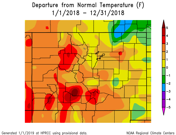
The following graphics depict preliminary departures from normal for both temperature and precipitation for 2018 across the state.
 |
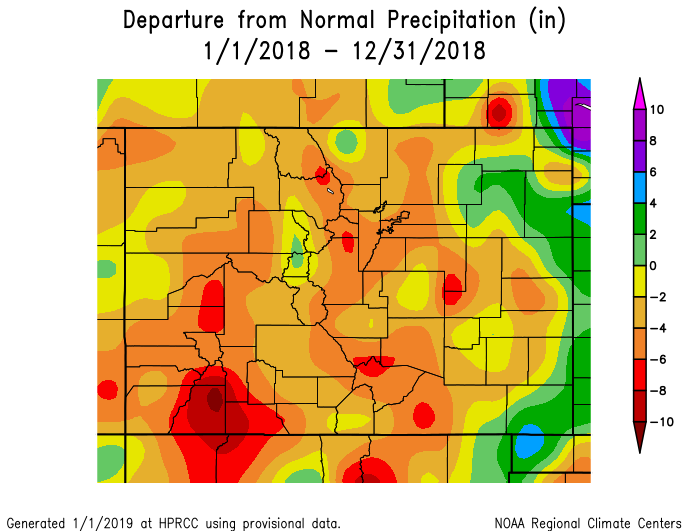 |
The 2018 average temperature in Alamosa was 44.0 degrees. This is 2.4 degrees above normal and makes 2018 the 5th warmest year on record in Alamosa, coming in behind the record average yearly temperature of 44.7 degrees set last year (2017). Alamosa recorded 5.77 inches of precipitation through out 2018, which is 1.54 inches below normal. A more detailed 2018 climate summary for Alamosa can be found at:
2018 Alamosa Annual Climate Summary
The 2018 average temperature in Colorado Springs was 51.2 degrees. This is 2.2 degrees above normal and makes 2018 tied with 2015 as the 8th warmest year on record in Colorado Springs, which remains behind the the record average yearly temperatures of 52.9 degrees set in 2012. Colorado Springs recorded 15.41 inches of precipitation through out 2018, which is 1.13 inches below normal. A more detailed 2018 climate summary for Colorado Springs can be found at:
2018 Colorado Springs Annual Climate Summary
The 2018 average temperature in Pueblo was 54.5 degrees. This is 2.5 degrees above normal and makes 2018 tied with 1933 as the 10th warmest year on record in Pueblo, well behind the record average yearly temperature of 56.5 degrees set in 1981. Pueblo recorded 7.72 inches of precipitation through out 2018. This is 4.85 inches below normal, and makes 2018 the 14th driest year on record, though well ahead of the record lowest yearly precipitation of 3.94 inches recorded through out 2002. A more detailed 2018 climate summary for Pueblo can be found at:
2018 Pueblo Annual Climate Summary

