
Daily Record Highs and All Time Monthly High Temperatures for March are in jeopardy of being broken from Wednesday through Saturday. Read More >
Pueblo, CO
Weather Forecast Office
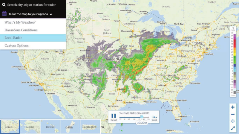 The NWS radar.weather.gov website has been the face of NWS radar data since 2003. When it was developed, the site illustrated what NWS could show using emerging technologies. It was a reliable site for viewing radar and warning data on the web, and it pushed the bounds of how NWS could provide data to customers in flexible GIS formats that they could integrate into their own data mashups. Even now, the site routinely receives around 1.75 million hits on an average day, and hundreds of millions of hits per day during active weather.
The face of technology has changed dramatically throughout the last decade. By 2018 more than 81% of Americans 13 years and over owned a smartphone. These devices have changed how and where we browse the internet. By 2018, mobile devices generated more than half of all website traffic worldwide.
The website radar.weather.gov is not mobile-friendly in its current form. It also utilizes technology (Flash) that will be obsolete in 2020 when Adobe stops updating and distributing Flash.
In April/May 2020, in response to these dramatic changes, NWS will replace the existing site and features with the following:
ACTIVE ALERTS
Warnings by State - click ATOM button
Excessive Rainfall Forecasts
River Flooding
Convective Outlooks
Hurricanes
Fire Weather Outlooks
UV Alerts
Space Weather
Winter Winter Forecasts
Enhanced Data Display(EDD)
PAST WEATHER
Climate Monitoring
Astronomical Data
Certified Weather Data
CURRENT CONDITIONS
Radar
River Levels
Observed Precipitation
Surface Weather
Upper Air
Marine and Buoy Reports
Climate Monitoring
Snow Cover
Satellite
Space Weather
Enhanced Data Display(EDD)
FORECAST
Severe Weather
Drought
Fire Weather
Front/Precipitation Maps
Graphical Foreast Maps
Rivers
Marine
Offshore and High Seas
Hurricanes
Aviation Weather
Climate Outlook
Enhanced Data Display(EDD)
WEATHER SAFETY
Owlie Skywarn - for kids
NOAA Weather Radio
StormReady
Natural Weather Hazard Statistics
Red Cross
Federal Emergency Management Agency(FEMA)
National Weather Service SafetyBrochures
US Dept of Commerce
National Oceanic and Atmospheric Administration
National Weather Service
Pueblo, CO
3 Eaton Way
Pueblo, CO 81001-4856
(719) 948-9429
Comments? Questions? Please Contact Us.

