Pueblo, CO
Weather Forecast Office
During the evening of Thursday, February 18th while a high wind episode was in progress, the Monarch Pass (MYP) AWOS weather station recorded wind gusts of 98 mph at 7:16 p.m. MST and again at 7:53 p.m. MST. In between those times, at 7:36 p.m., the MYP weather station recorded winds out of the west at 62 mph, with a gust to 148 mph.
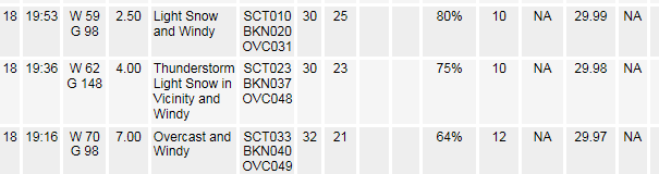
At the time of the reported 148 mph wind gust, the Monarch Pass (MYP) AWOS weather station reported thunder and light snow in the vicinity. Conceptually, a shower moving in from the west could accelerate the winds and cause even higher wind gusts.
The Colorado Division of Aeronautics maintains high mountain AWOS weather stations for aviation safety purposes across the state, and stated that the Monarch Pass (MYP) AWOS weather station was operating within the parameters of FAA required tolerances before, during and after the 148 mph gust. The wind sensor stopped reporting wind data later Thursday night. When the heating elements stop performing, there is a loss of data, not a false spiking up of recorded wind gusts. On Friday, the Monarch Pass AWOS was undergoing maintenance, replacing heating elements to allow it to perform optimally. The Colorado Division of Aeronautics considers the 148 mph wind gust above Monarch Pass to be true and accurate, and NWS Pueblo concurs.
Remarkably, at the same time, the Colorado Department of Transportation weather station on US Highway 50, 700 feet below, recorded a wind out of the north, at just 32 mph.
The MYP weather station is well above US Highway 50 at Monarch Pass. Monarch Pass is at an elevation of 11,312 feet above sea level, while the MYP AWOS weather station is east of the roadway at the top of a curved mountainside at 12,031 feet above sea level.
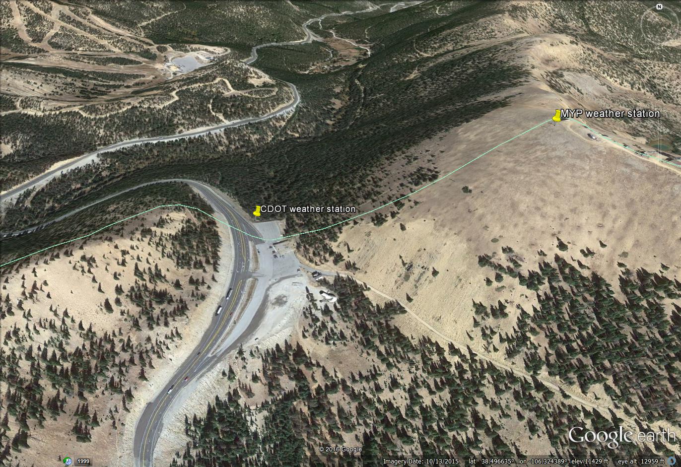
(image courtesy Google Earth)
Below is a link to information on the 12 Mountain AWOS sites, most of them near high mountain passes in Colorado...
https://www.codot.gov/programs/aeronautics/co_awos
There is typically much more wind at the MYP AWOS weather station than at the CDOT weather station, due to the aerodynamic shape of the mountainside, especially with west winds . There was no damage reported by technicians at the scene today. A check with organizations that have structures in the mountaintop revealed no major damage, not totally surprising since these structures are designed to withstand very high winds. It is also noteworthy that the air is thinner at 12,000 feet, compared to sea level, therefore it takes higher winds speeds at high altitude to do damage.
The Colorado State Climatologist states that the previous accepted, yet UNOFFICIAL highest recorded wind gust in Colorado was at the National Center for Atmospheric Research (NCAR) in Boulder on January 25, 1971. That was a 147 mph wind gust, measured with a 3-cup anemometer recorded automatically on a paper chart with a pen. It should be noted that modern electronic wind sensors tend to damp out the instantaneous wind gusts, recording slightly lower values.
ACTIVE ALERTS
Warnings by State - click ATOM button
Excessive Rainfall Forecasts
River Flooding
Convective Outlooks
Hurricanes
Fire Weather Outlooks
UV Alerts
Space Weather
Winter Winter Forecasts
Enhanced Data Display(EDD)
PAST WEATHER
Climate Monitoring
Astronomical Data
Certified Weather Data
CURRENT CONDITIONS
Radar
River Levels
Observed Precipitation
Surface Weather
Upper Air
Marine and Buoy Reports
Climate Monitoring
Snow Cover
Satellite
Space Weather
Enhanced Data Display(EDD)
FORECAST
Severe Weather
Drought
Fire Weather
Front/Precipitation Maps
Graphical Foreast Maps
Rivers
Marine
Offshore and High Seas
Hurricanes
Aviation Weather
Climate Outlook
Enhanced Data Display(EDD)
WEATHER SAFETY
Owlie Skywarn - for kids
NOAA Weather Radio
StormReady
Natural Weather Hazard Statistics
Red Cross
Federal Emergency Management Agency(FEMA)
National Weather Service SafetyBrochures
US Dept of Commerce
National Oceanic and Atmospheric Administration
National Weather Service
Pueblo, CO
3 Eaton Way
Pueblo, CO 81001-4856
(719) 948-9429
Comments? Questions? Please Contact Us.

