#7 Summer 2018 Hail Storms
June 13th - Colorado Springs / Fountain, June 18-19th - Denver Metro, and August 6th Colorado Springs
Colorado has always been known for hail storms, but during the Summer of 2018, there were multiple severe hail storms that developed over Colorado's largest population centers, the Denver metropolitan and Colorado Springs, causing around $620 million in damage spanning three different events.
June 13th, 2018 El Paso County - Colorado Springs/Fountain:
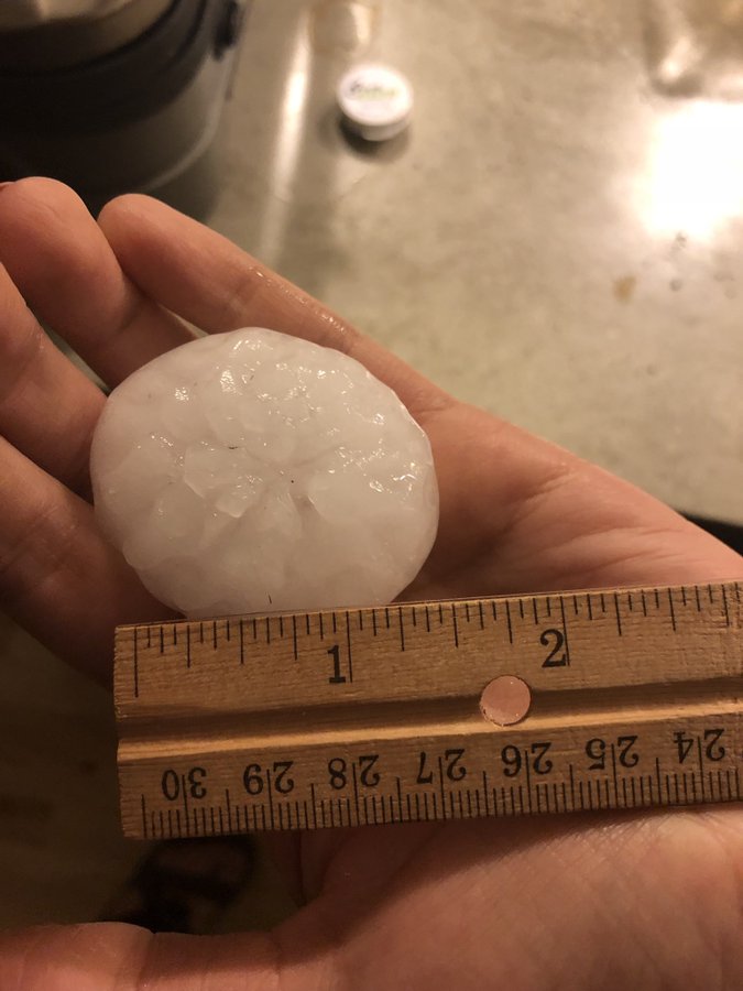
A rare nocturnal severe thunderstorm developed over southern El Paso County during the early morning hours of June 13th, 2018. The severe thunderstorm dropped 3.0" hail over the southern Colorado Springs metropolitan area and Fountain. The estimated damage caused by this event was around $169 million dollars. Follow this link for an in-depth meteorological analysis and for more images: https://www.weather.gov/pub/20180613_ElPaso_Hail
 |
||||||||
0.5 degree Base Reflectivity of the Nocturnal Hail Event
|
 |
 |
 |
 |
|
Dry and wet hail |
Damage in Fountain, Colorado Courtesy of Jennifer Stark |
Damage in Fountain, Colorado Courtesy of Jennifer Stark |
Hail Stones in Fountain, Colorado. Courtesy of Jennifer Stark |
June 18th, 2018 - Denver Metropolitan Area:
Whenever a persistent, long lasting severe thunderstorm develops over a major metropolitan area, the damage is widespread and costly. Though this storm didn't produce the largest hailstones of the three mentioned in this overview, it was the costliest. This thunderstorm dropped 3" hailstones in Louisville, Colorado. Follow this link to the NWS BOU write-up of the storm: https://www.weather.gov/bou/HailJune18th. This event would end up being over-shadowed by the next day's hail and tornadic event.
 |
||||||||
0.5 degree Base Reflectivity of the Nocturnal Hail Event
|
June 19th, 2018 - Denver Metro Area
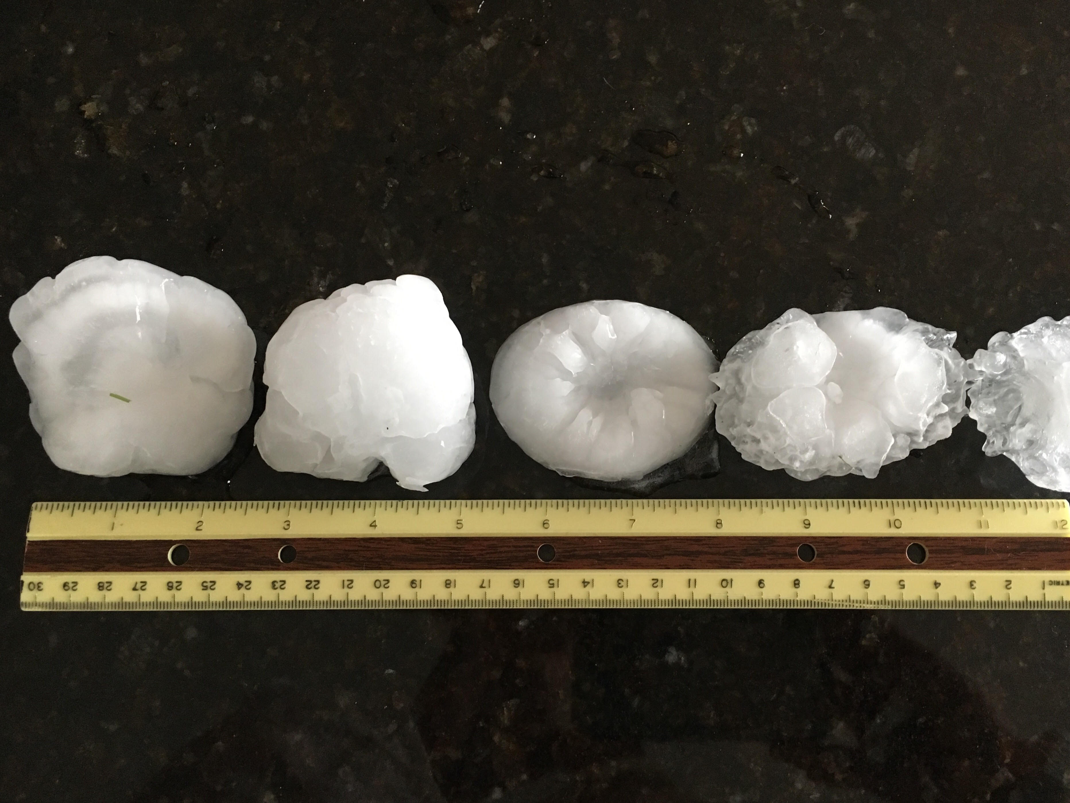
For the second day in a row, giant hail up to 3 inches in diameter pummeled portions of the Front Range Urban Corridor from north of Colorado Springs to Greeley, and extended across the northeast plains of Colorado. Collapsed roofs due to hail were reported, with major hail damage across northern and southern portions of the Denver metro area. The first supercell of the day moved off the foothills in north Boulder, hitting Niwot with golfball and smaller sized hail that accumulated to several inches deep, snarling travel across the area. That same supercell dropped up to baseball hail in a swath all across southern Weld County, over about the same areas as supercells from the previous day. The storm also generated a brief tornado near Prospect Valley that was visible from at least 25 miles away, including a few "lucky" travelers on flights into/out of DIA. A second supercell moved across the southern and southeast sides of metro Denver, producing baseball to 3.00" diameter hail across a heavily populated area from Greenwood Village to Englewood to Arapahoe Park and Aurora. Yet another supercell across the crest of the Palmer Divide and into northern El Paso County dropped 3.00" diameter hail in Black Forest, and 2" diameter hail in Monument. Greeley also had golfball hail that accumulated several inches deep from another supercell in the early afternoon. Another interesting aspect of this storm was the sheer number of hail reports golfball or larger, 21 in total from all across eastern Colorado. There were also a few unusually large hail reports in areas not normally accustomed to them. Virginia Dale, at 7,000 feet elevation in the foothills northwest of Fort Collins, had golfball hail, while Lake George, at 8,000 feet elevation in eastern Park County, had baseball hail. Frontage roads along Interstate 76 northeast of Denver were also flooded and washed out. In Lincoln County, large hail in the Arriba and Genoa areas damaged vehicles along Interstate 70. A total of four short-lived tornadoes touched down in the open country of Lincoln and Weld counties. Thunderstorms in Lincoln, Washington, and Yuma Counties also produced up to 2.5" hail and damaging wind gusts up to 70 mph.
Both the June 18th and 19th hailstorms combined for a total of $276 million in damage across the Denver Metro area.
 |
||||
0.5 Degree Base Reflectivity of the Damaging Hail and Tornadic Event
|
 |
 |
 |
 |
|
Hail Damage in Aurora, |
Hailstone Compared to |
Hail Accumulation in Firestone, Colorado |
Hail Accumulation in Greeley, Colorado |
 |
|
 |
|
|
Hail in Greeley, Colorado |
Hail Stone in Southeast Aurora, Colorado |
Hail Stones in Southeast Denver, Colorado |
 |
||||
June 19th Prospect Valley Tornado
|
August 6th, 2018 - Colorado Springs:
A very strong severe thunderstorm develop over Teller County during the afternoon of August 6th, 2018, then traveled southeast over the Highway 24 corridor, reaching the Cheyenne Mountain Zoo. The severe thunderstorm dropped 3 - 4" hailstones over the Cheyenne Mountain Zoo and southern Colorado Springs. The estimated damage caused by this event was $173 million. A good overview of the injuries at Cheyenne Mountain Zoo can be found here. Follow this link for a meteorological write-up of the event: https://www.weather.gov/pub/20180806_ElPasoHail
 |
 |
| 0.5 degree Base Refelctivity of the Severe Thunderstorm |
0.5 degree Base Velocity of the Severe Thunderstorm |
 |
| Satellite View of the Prolific Hail Event |
 |
|
 |
|
| Broadmoor Bluffs Hail Stone |
Hail next to a Hail Card |
Large Hail |
Hail Stones |