Gusty winds are expected from portions of the Mid-Atlantic into the Northeast through the night following the system that brought rain to the area. An atmospheric river will move into the Northwest late today into Saturday bringing moderate to heavy rainfall, mountain snow, windy conditions, and high surf to the area over the weekend. Read More >
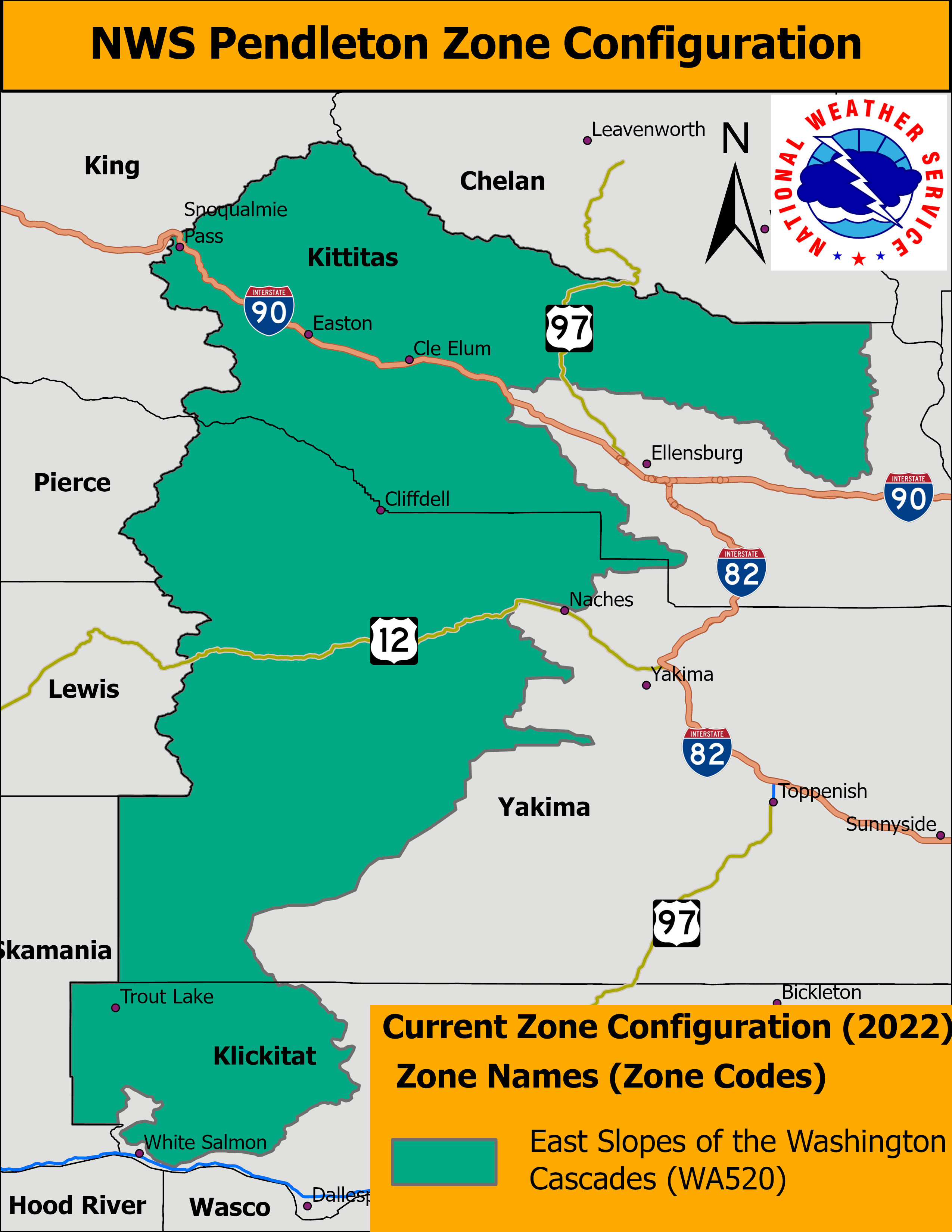
Effective on March 8, 2023, at 1:00 PM Pacific Standard Time (PST), 21:00 Coordinated Universal Time (UTC), the NWS Weather Forecast Office in Pendleton, OR (PDT) will complete changes to Public Weather Forecast Zones encompassing the Washington counties of Kittitas, Yakima, and Klickitat. After this change, all public forecasts and related products will use the new zone numbers and names shown below.
If March 8, 2023 is declared a Critical Weather Day, this implementation will be postponed to March 9, 2023 at 21:00 UTC.
These changes are intended to provide increased specificity, enhanced representativeness, and improved accuracy of forecast, watch, warning, and advisory products in the Public Weather Program.
NWS Pendleton will be converting the Washington Public Forecast Zone 520, East Slopes of the Washington Cascades, into two (2) separate zones. This change will allow differences in climatology to properly be addressed while better reflecting the influences of complex terrain that can result in weather changing significantly over short distances. The public forecast zone will be divided roughly north to south into two zones. The westernmost zone will become a new zone named “Upper Slopes of the Eastern Washington Cascade Crest” and the easternmost zone will become a new zone named “Lower Slopes of the Eastern Washington Cascade Crest.”
Key Points:
 |
 |
Table 1: Universal Geographic Codes (UGC): Current Public Zone Forecast Name
----------------------------------
WAZ520: East Slopes of the Washington Cascades
Table 2: UGC: New Public Zone Forecast Name
-------------------------------
WAZ522: Upper Slopes of the Eastern Washington Cascade Crest
WAZ523: Lower Slopes of the Eastern Washington Cascade Crest
Updated public zone shapefiles are available for download via the NWS GIS Portal.
For more information or for comments, please contact us via email at w-pdt.webmaster@noaa.gov or (541) 276-7832.