Gusty winds are expected from portions of the Mid-Atlantic into the Northeast through the night following the system that brought rain to the area. An atmospheric river will move into the Northwest late today into Saturday bringing moderate to heavy rainfall, mountain snow, windy conditions, and high surf to the area over the weekend. Read More >
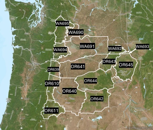
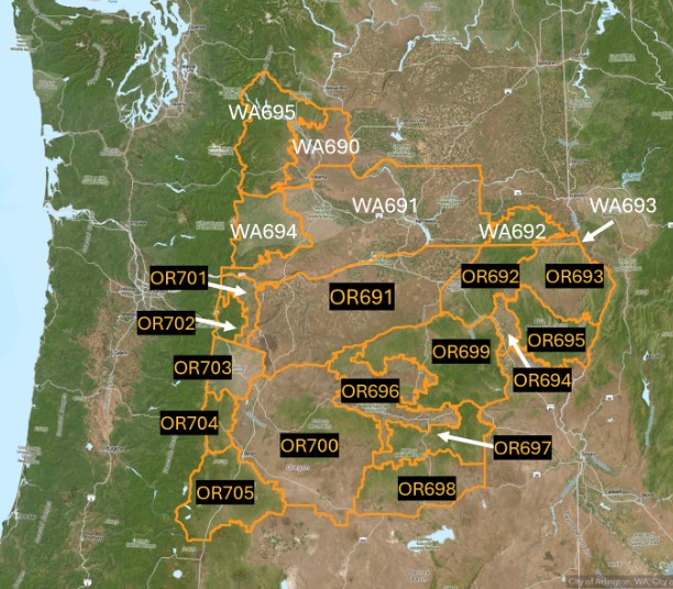
The changes will affect central and north central Oregon, the east slopes of the Oregon Cascades, the eastern Columbia River Gorge of Oregon, the Lower Columbia Basin of Oregon, the Blue Mountains, Grande Ronde, John Day Valleys, Wallowa County, and a portion of the Burns District. This is tentatively set for March 18, 2025 at 2 PM PDT (2100 UTC). No changes will be made to the eastern Washington fire weather zones.
Why is the National Weather Service Weather Forecast Office in Pendleton, OR proposing a change to the fire weather zones in central and northeast Oregon?
In 2022, fire weather zones across eastern Washington were reconfigured to match the Fire Danger Rating Areas (FDRAs) per request of a working interagency group. Fire Danger Rating Areas are based on an analysis of the components of fire danger: vegetation, climate, and topography. Multiple agencies that cover eastern Oregon requested the same boundary changes based on the success of the Eastern Washington fire weather zone changes. Aligning the Fire Weather Zones with the FDRAs will simplify relevant information and reduce the confusion across differing boundaries and among fire management personnel.
What steps were taken during the collaboration process?
A survey was sent to the fire weather partners in October 2023, and a majority of the responses were in favor of the alignment to match fire weather zones with the fire danger rating areas. In January 2024, a video conference was held discussing the initial proposal of the new fire weather zones. Since the conference call, there have been multiple collaboration emails with various agencies. Support was given for the fire zones that cover central and northeast Oregon.
Questions or comments
Christel Bennese, NWS Pendleton Fire Weather Program Lead – christel.bennese@noaa.gov
Matthew Callihan, NWS Pendleton Fire Weather Program Lead – matthew.callihan@noaa.gov
Old Fire Weather Zones

OR610: East Slopes of the Central Oregon Cascades
OR611: Deschutes National Forest - minus Sisters Ranger District
OR639: East Slopes of the Northern Oregon Cascades
OR640: Central Mountains of Oregon
OR641: Lower Columbia Basin of Oregon
OR642: Southern Blue and Strawberry Mountains
OR643: Northern Blue Mountains of Oregon
OR644: Central Blue Mountains
OR645: Wallowa District
New Fire Weather Zones

Proposed Fire Weather Zones and Names
OR691: Lower Columbia Basin of Oregon
OR692: Northern Blue Mountains of Oregon
OR693: Canyon Grasslands of Wallowa County
OR694: Grande Ronde Valley of Oregon
OR695: Eagle Cap Wilderness
OR696: John Day Valley
OR697: Central Blue Mountains
OR698: Southern Blue Mountains
OR699: Western Forested Blue Mountains
OR700: Central Mountains of Oregon
OR701: Eastern Columbia River Gorge of Oregon
OR702: East Slopes of the Mt. Hood National Forest
OR703: Warm Springs Reservation
OR704: Northern Deschutes National Forest
OR705: Southern Deschutes National Forest
The NWS Service Change Notice is available here.
GIS Portal for fire zone shapefiles is located at https://www.weather.gov/gis/FireZones