|
NWS Hydrologic Research Lab (HRL)
Distributed Model Intercomparison Project
(DMIP)
Draft Science Plan
August 2000
TABLE OF CONTENTS
EXECUTIVE SUMMARY.........................................................................................
3
1.0 INTRODUCTION...............................................................................................
4
1.1 Background.........................................................................................................
4
1.2 Major Goals.......................................................................................................
6
1.3 Science Questions................................................................................................
7
1.4 Operational Questions.....................................................................................
7
2.0 EXPERIMENTAL DESIGN................................................................................
7
3.1 Plan Development...............................................................................................
7
3.2 Plan Elements.................................................................................................
7
3.0 REFERENCES...................................................................................................
10
APPENDICES
1. Draft DMIP Milestones.........................................................................................
12
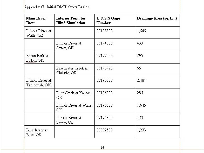
2. Initial DMIP Study Basins......................................................................................
14
EXECUTIVE SUMMARY
The Hydrologic Research Lab (HRL) of the National Weather Service (NWS) proposes
the Distributed Model Intercomparison Project (DMIP). The
intent of DMIP is to invite the academic community and other researchers
to help guide NWS distributed modeling research by participating
in a comparison of distributed models applied to test data sets.
HRL will provide data sets for several basins. Participants
will download the data sets and run their models in continuous simulation
mode. Model simulations will be compared to observed streamflow
data as well as simulations generated from a lumped application
of the Sacramento Soil Moisture Accounting (SAC-SMA) model.
Participants will be invited to meet in an HRL sponsored workshop
to discuss results and future directions. Results of DMIP
will be used to guide future HRL distributed modeling research and
application.
1.0 INTRODUCTION
1.1 Background
Numerous studies have been conducted in the past two decades that
point to the sensitivity of runoff hydrographs to spatial and temporal
variations in precipitation. Many of these studies examined the effects
of raingage sampling errors on the outflow hydrograph. In an early and
oft-quoted work, Wilson et al., [1979] showed that the spatial distribution
of rainfall had a marked influence on the runoff hydrograph from a small
catchment. On the other hand, Beven and Hornberger [1982] stated that rainfall
patterns have only a secondary effect on runoff hydrographs, while a correct
assessment of the global volume of rainfall input in a variable pattern
is more important in simulating streamflow hydrographs. On a small
watershed, Krajweski et al., [1991] found a higher sensitivity to the temporal
resolution of precipitation than to the spatial resolution.
Ogden and Julien [1994] performed tests that identified when spatial and
temporal variability of precipitation was dominant. Troutman,
[1983], Ogden and Julien [1994], and Shah et al.,[1996a,b] also investigated
the effects of precipitation variability on hydrologic simulations.
It is interesting to note that the majority of these and other
studies were based on synthetically generated precipitation and streamflow
records. Usually, comparisons were made against a ‘reference' or
‘truth' hydrograph generated by running the hydrologic model at the finest
data resolution. Synthetically generated data were often used due
to the lack of appropriately long periods of observed data. Moreover,
many of studies emphasizing the importance of the spatial variability of
precipitation used models containing the Hortonian runoff generation
mechanism. It is now recognized that runoff results from a complex variety
of mechanisms and that in some basins, a significant portion of runoff
hydrographs is derived from slower responding subsurface runoff [Wood et
al., 1990].
Obled et al., [1994] commented that numerical experiments in
the literature were based on the use of models which may be only ‘a crude
representation of reality'. Furthermore, they argued that the actual
processes at work in a basin may not be those predicted by the model.
Thus, the research in the literature may have shown the sensitivity of
a particular model to the spatial variability of precipitation,
not the sensitivity of the actual basin. The work of Obled
et al, (1994) is significant in that they were perhaps the first to examine
the effects of the spatial variation of rainfall using observed precipitation
and streamflow data. In addition, the model used in their studies
focused on saturation excess runoff as the main runoff generation mechanism.
In simulations against observed data, they were unable to prove the value
of distributed inputs as they had intended. A semi-distributed representation
of the basin did not lead to improved simulations compared to a lumped
basin modeling scenario. The authors reasoned that the runoff mechanism
may be responsible for the lack of improvement:
"If, on the other hand, the dominant process involves either
surface or subsurface contributing areas of the Dunne type, then most of
the water infiltrates and local variations in input will be smoothed as
the water is stored and delayed within the soil.....this type of mechanism
may be much less sensitive to different rainfall patterns at the scale
of small catchments"
Winchell et al [1998] and Winchell et al.,[1997] extend
this theme by noting that there has been a bias towards the use of infiltration-excess
runoff mechanisms as opposed to the saturation excess type. Their
work with both types of runoff generation mechanisms found that saturation-excess
and infiltration excess models respond differently to uncertainty in precipitation.
They suggest that generalizations concerning the effects of rainfall variability
on runoff generation cannot be made. Koren et al., [1999] came to
a similar conclusion based on simulation results from several different
rainfall-runoff partitioning mechanisms.
Nonetheless, a large volume of research continues to emerge
that addresses the possibility of improving lumped hydrologic simulations
by using distributed and semi-distributed modeling approaches which account
for the spatial variation of not only physiographic basin features but
of precipitation as well. Recently, the availability of high resolution
precipitation estimates from different weather radar platforms has intensified
this investigation. Most efforts have focused on event-based modeling and
mixed and somewhat surprising results have been realized compared to the
numerical results discussed above.
Pessoa et al., [1993] found that adequately averaged gridded
precipitation estimates from radar were just as viable as fully distributed
estimates for streamflow simulation using a distributed model. Kouwen
and Garland [1989] investigated the effects of radar data resolution and
attempted to develop guidelines for the proper resolution of input rainfall
data resolution. They noted that spatially coarser rainfall data
sometimes led to better hydrograph simulation due to the smoothing of errors
present in finer resolution rainfall information. In preliminary
testing limited to a single extreme event, Kenner et al., [1996] reported
that a 5 sub-basin approach produced better hydrograph agreement than a
lumped representation of the basin. Sub-basin rainfall hyetographs
revealed spatially varied precipitation totals for the event. Refsgaard
[1997] illustrated the concepts of parameterization, calibration, and validation
of distributed parameter model. Noting that hydrologists often assume
that a distributed model calibrated to basin outlet information will adequately
model interior processes, he realized poor simulations of discharge and
piezometric head at 3 interior gaging stations.
In contrast, Michaud and Sorroshian [1994] found that a complex
distributed model calibrated at the basin outlet was able to generate simulations
at 8 internal points that were at least as accurate as the outlet simulations.
These results underscore one of the mains advantages of distributed parameter
hydrologic modeling: the ability to predict hydrologic variables at interior
points. They also concluded that a simple distributed model proved
to be just as accurate as a complex distributed model given that both were
calibrated and noted that model complexity does not necessarily lead to
improved simulation accuracy.
It is a concern that few of the studies have shown a direct comparison
of distributed model and lumped model results to observed streamflow data.
The emergence of high resolution data sets, GIS capabilities, and rapidly
increasing computer power have pushed distributed hydrologic models to
the forefront of research and development. While the utility of distributed
models to predict interior hydrologic processes is well known, few studies
have specifically addressed the improvement of distributed models over
lumped models for predicting basin outflow hydrographs. As a consequence,
the hypothesis that higher resolution data will lead to more accurate hydrograph
simulations remains largely untested.
A few years ago, the Hydrologic Research Laboratory (HRL) of
the NWS began a major research effort to address the question: ‘How can
the NWS most effectively utilize the NEXRAD data to improve its river forecasts?'
In Phase I of this research, modeling tests have involved existing NWS
hydrologic models applied in a lumped and semi-distributed format.
The model used in these efforts was the Sacramento Soil Moisture
Accounting Model (SAC-SMA). In Phase 2, new models such as
gridded distributed models will be examined and developed.
In the Phase 1 semi-distributed simulations, several RFC scale
basin were disaggregated into 5 to 8 sub-basins in an effort to capture
the spatial variability of precipitation and soil/vegetation properties
(Smith et al., 1999). Simulations from lumped and semi-distributed
approaches were compared to observed data for five basins (with drainage
areas ranging from 820 to 4200 sq. km.) using results of continuous simulations
over a period of 4-6 years. The analyses suggest that the spatial rainfall
averages derived from NEXRAD data can improve flood prediction in mid/large
basins as compared to gage-only averages. While the semi-distributed
approach shows potential for improved hydrograph simulation, parameterization
problems and noisy data can eliminate benefits when applied to mid/large
basins having significant damping effects (e. g., those caused by deep,
well drained soils). A more noticeable benefit from the semi-distributed
approach is achieved for basins with a fast response runoff (Smith et al,
2000) However, optimal model parameters from the lumped approach
may be far from the optimal parameter set for the semi-distributed
approach.
It is clear that distributed modeling is in the future.
However, there is no clear pathway in the literature towards distributed
models that will suit NWS forecasting needs. To address this
problem and the other issues mentioned above, HRL is initiating
the Distributed Model Intercomparison Project (DMIP).
The intention is to access broad scientific community experience
to help guide NWS/HRL distributed modeling research and application.
Within DMIP, HRL will make available data sets for a number of basins.
Participants will download the data sets and run their models to
generate simulations at specific locations. HRL will generate
statistics comparing the simulations to observed streamflow as well
as to simulations from a calibrated lumped SAC-SMA model.
Participants will be invited to a workshop at HRL to present
their models and results. The workshop will also provide opportunities
to discuss further research and publication of results.
1.2 Major Goals of DMIP
A. To develop methods to optimally utilize NEXRAD and other spatial
sets data to improve RFC scale river simulations
B. To help guide NWS HL future hydrologic distributed
modeling research, science, and application.
1.3 Science Issues
Among the science issues that could be addressed by an intercomparison
of distributed modeling approaches are:
1. What characteristics identify a basin as one likely to
benefit from distributed modeling (i.e., accounting for the spatial
variability of precipitation and model parameters)? Can these characteristics
be identified?
2. What is the tradeoff in computational element size required
to capture the essential spatial variability of precipitation versus the
size required to route runoff to stream channels?
3. What level of model complexity is required to realize
improvement in basin outlet simulations?
4. What is the potential for distributed models set up
for basin outlet simulations to generate hydrographs at interior locations
for flash flood forecasting?
5. Which approaches work well for handling sub-grid
heterogeneity of hydrologic variables?
1.4 Operational Issues
Issues that need to be addressed before a model can be implemented
in NWSRFS for operational use are:
1. Computational requirements in an operational environment
2. Run time modifications and updates in an operational
forecasting setting.
3. Parameterization and calibration requirements.
4. Does ease of parameterization/calibration of a physically
based distributed parameter model warrant its use, even when it might not
provide improvements over simpler (but harder to calibrate) lumped conceptual
models?
2.0 EXPERIMENTAL DESIGN
2.1 Plan Development: HL will work with specific outside agencies/institutions
to help design the project.
2.2 Proposed Plan Elements
A. Model Simulations:
Participants will generate hydrographs in two ways:
A. Simulations using uncalibrated versions of their
model.
B. Simulations using models calibrated at basin
outlet.
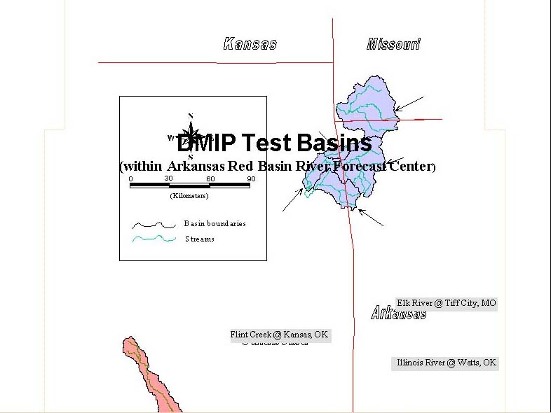
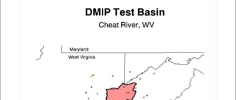
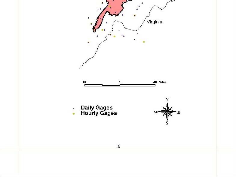
1. Participants will test their models on basins (200-2500
sq. km.) to produce basin outlet hydrographs.
2. Where observed data are available, models will also produce
a ‘blind' simulation at interior sub-basin points as a test of providing answers
at ungaged sites. Participants will not perform explicit calibration above
these points. See Appendix 3 for a listing of the proposed interior sites.
3. Models will produce simulations at HL specified interior
ungaged points to assess variability of predictions amongst models.
B Models will be run in continuous retrospective
simulation mode. Calibration period will be from 1993 (or date of
earliest sound data) to May, 1999. Verification period June, 1999
to present .
C. Basins will be limited to those in used by HL distributed
modeling research
D. Basic data sets will be provided by HL on web
or ftp site
E. Participants will model one or more basins to produce
a deterministic simulation.
F. Participants will submit their simulations to HL in
a standard format. HL will produce a comprehensive analysis of all
simulations compared to observed data and lumped SAC-SMA simulations.
This analysis will be presented at HL hosted workshop.
G. Standard: Simulations from participants' models
will be compared to those generated from a calibrated lumped SAC-SMA model.
H. It is envisioned that a paper describing the results
of the workshop will be submitted to a peer-review journal.
Participants will be coauthors. It is hoped that a special issue
of a journal would be dedicated to the results of DMIP.
I. Evaluation Criteria: standard statistical measures for hydrograph
comparison will be used.
2.3 Data Types Provided by HL
A. DEM: resolution is 400 m. in Albers Equal Area
Projection. Higher resolution data such as the 30 m. data from USGS could
be made available.
B Basin Boundary LAT/LON pairs
C. LAT/LON location of interior computational points.
D. Hourly streamflow from USGS.
E. NEXRAD Stage III xmrg files and utilities for
usage
F. NRCS Soils (Derived by D. Miller from STATSGO)
G. Energy forcing fields (possibly from NCEP regional re-analysis)
H. Vegetation
I. NDVI-5 Greenness Fraction Data
J. Other, as donated by participants
Participants needing other data will be responsible for obtaining
them.
2.4 Workshop at OH: we will ‘host' a workshop after a specified period
of time where participants will present their results and discuss the following:
A. Model Overview
B. Model parameterization
C Model calibration
D. Computational Time
E. Comparison Statistics: 1) at parent basin
outlet, 2) at interior points where observed streamflow data is available;
3) HL designated points for variability assessment. Comparison
statistics will be generated using observed flow records and the calibrated
lumped application of the SAC-SMA model.
F. Future modeling studies; publication of results; special
issue of journal.
2.5 Funding: HL will "host" this intercomparison, not "support" it, i.e.,
HRL will supply the organizational legwork but participants should look for
some funds from their own or other organizations.
4.0 REFERENCES
Beven, K.J., and G.M. Hornberger, Assessing the effect of
spatial pattern of precipitation in modeling stream flow hydrographs, Water
Resources Bulletin, 823-829, 1982.
Koren, V. I., B.D. Finnerty, J.C. Schaake, M.B. Smith, D.J. Seo, Q.Y.
Duan, Scale dependencies of hydrology models to spatial variability of
precipitation, Journal of Hydrology, 217, 285-302, 1999.
Krajewski, W.F., V. Lakshmi, K.P. Georgakakos, and S. C.
Jain, A monte -carlo study of rainfall sampling effect on a distributed
catchment model, Water Resources Research, Vol. 27, No. 1, 119-128, 1991.
Michaud, J., and S. Sorooshian, Comparison of simple versus complex
distributed runoff models on a midsized semiarid watershed, Water Resources
Research, Vol. 30, No. 3. 593-605, March, 1994.
Obled, C.H., J. Wendling, and K. Beven, The sensitivity of hydrological
models to spatial rainfall patterns: an evaluation using observed data,
Journal of Hydrology, 159,305-333, 1994.
Ogden, F.L., and P.Y. Julien, Runoff sensitivity to temporal and
spatial rainfall variability at runoff plane and small basin scales, Water
Resources Research, Vol. 29, No. 8, 2589-2597, 1993
Ogden, F.L, and P.Y. Julien, Runoff model sensitivity to radar rainfall
resolution, Journal of Hydrology, 158, 1-18, 1994.
Pessoa, M.L., R.L, Bras,. and E.R. Williams, Use of weather radar
for flood forecasting in the sieve river basin: a sensitivity analysis,
Journal of Applied Meteorology, 32 (3), 462-475, 1993.
Refsgaard, J.C., Parameterisation, calibration, and validation of distributed
hydrological models, Journal of Hydrology, (198), 69-97, 1997.
Shah, S.M.S., P.E. O'Connell, and J.R.M Hosking, Modeling
the effects of spatial variability in rainfall on catchment response. 1.
Formulation and calibration of a stochastic rainfall field model, Journal
Hydrology, 175, 66-88, 1996a.
Shah, S.M.S., P.E. O'Connell,, and J.R.M. Hosking,, Modeling the
effects of spatial variability in rainfall on catchment response. 2. Experiments
with distributed and lumped models, Journal of Hydrology, 175, 89-111,
1996b.
Smith, M.B., V.I. Koren, Z. Zhang, D. Wang, S. Reed., 2000, ‘Semi-distributed
vs Lumped Model Simulations: Comparisons Using Observed Data for RFC Scale
Basins', EOS, Transactions of the American Geophysical Union, 2000 Spring
Meeting, Vol., 81, No. 19. Abstract only.
Smith, M. B, V. Koren, D. Johnson, B.D. Finnerty, and D.J.
Seo, Distributed Modeling: Phase 1 Results, NOAA Technical Report
NWS 44, 210 pp., National Weather Service Hydrologic Research
Lab, February 1999.
Troutman, B.M., Runoff Prediction Errors and Bias in Parameter Estimation
induced by Spatial Variability of Precipitation, Water Resources Research,
Vol 19. No. 3, 791-810, 1983.
Wilson, C.B., J.B. Valdes, and I. Rodriquez-Iturbe, On the Influence
of the spatial distribution of rainfall on storm runoff, Water Resources
Research, Vol 15(2), 321-328, 1979.
Winchell, M., H.V. Gupta, and S. Sorooshian, Effects of
radar-estimated precipitation uncertainty on different runoff generation
mechanisms, Rep. HWR No. 97-080, 285 pp., Department of Hydrology and Water
Resources, University of Arizona, 1997.
Winchell, M., H.V. Gupta, and S. Sorroshian, ‘On the simulation of infiltration-
and saturation-excess runoff using radar-based rainfall estimates: Effects
of algorithm uncertainty and pixel aggregation', Water Resources
Research, Vol 34, No. 10, 2655-2670, 1998.
Wood, E.F., M. Sivapalan, and K. Beven, Similarity and scale in catchment
storm response, Review of Geophysics, 28(1), 1-18, 1990.


|

