In early October 2022, Northeast RFC, and other River Forecast Centers, updated the look and feel of the ensemble river guidance available to our customers and partners. There are two different sources of river ensemble guidance: the MMEFS (Meteorological Model Ensemble River Forecasts), which contain guidance from two different meteorological model sets -- the Global Ensemble Forecast System (GEFS) and North American Ensemble Forecast System (NAEFS); and the HEFS (Hydrologic Ensemble Forecast Service).
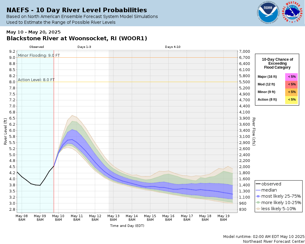
The changes made to the graphics were informed through social science studies conducted by the Nurture Nature Center in Easton, PA. Recommendations as described in the Bulletin of the American Meteorological Society report published in October 2021, entitled “Improving the Use of Hydrologic Probabilistic and Deterministic Information in Decision-Making“, along with input from previous experimental ensemble products, were used to update the graphical representation of hydrologic forecast uncertainty as shown.
The concepts for this graphic were tested and surveyed by the team working with the Nurture Nature Center in order to meet the needs of both residential and professional users related to probabilistic and deterministic forecasts. Users provided discrete and helpful suggestions about the use of color, specific language and word choice in legends, and placement of information to remove barriers to understanding. For example, the darkest blue region highlights the river levels that have the greatest chance of occurring at that location in time. The recommendations also led to the enhancement of the two legends: 1) 10-day chance of exceeding flood category in the top right; and 2) Redesign of the legend that contain numeric quantifications of probabilities, as well as observed, median, and forecast river levels in the lower right.
The changes made in October 2022 also unify the MMEFS and HEFS graphics under the same style and presentation, so that users can make more direct comparisons between the output of each system. Examples of the old graphics and new graphics for each can be found at the bottom of this page.
Finally, the largest change made is that the MMEFS graphics now are presented in .png format instead of .gif format. This means that all direct links to graphics will no longer work or contain an outdated image. For example, a user who directly linked to https://www.weather.gov/images/erh/mmefs/WOOR1.NAEFS.SSTG.expvalue.gif would now need to link to https://www.weather.gov/images/erh/mmefs/WOOR1.NAEFS.SSTG.expvalue.png instead. Everything else in the web address and filename remain the same -- the only change is .png instead of .gif.
The MMEFS webpage at https://www.weather.gov/erh/mmefs now contain the new graphics for both MMEFS and HEFS. Direct links to the graphics also work. Additionally, the HEFS graphics can be found on individual gage pages at https://water.weather.gov by hovering over the "Probability Information" tab (where available) and selecting the "Short Term Probabilistic Guidance" option.
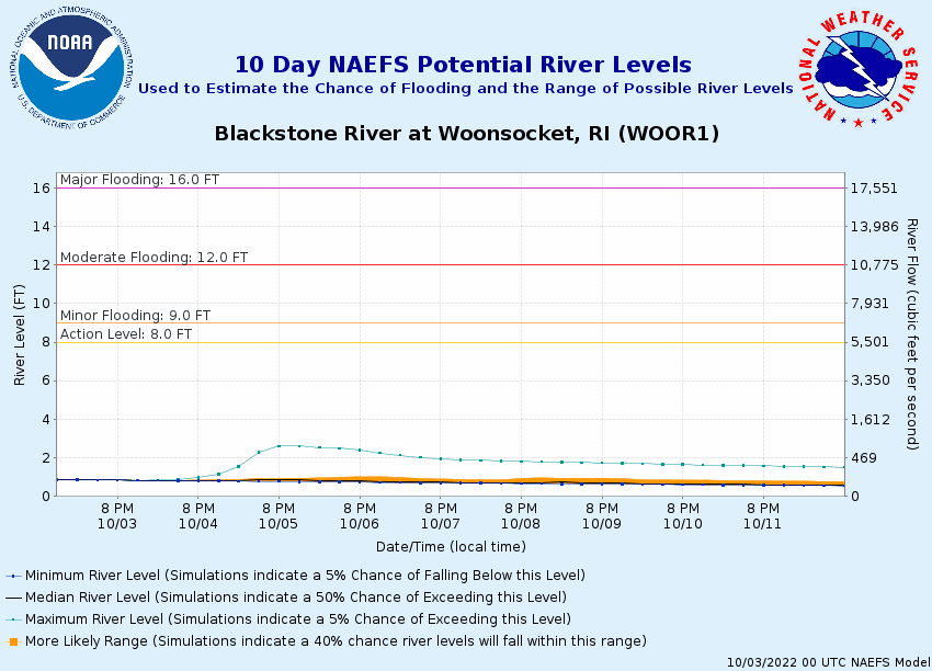
MMEFS
| OLD | NEW |
 |
 |
HEFS
| OLD | NEW |
 |
 |

