Northeast RFC
River Forecast Center
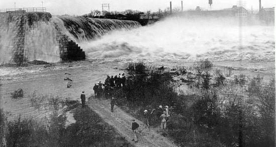
Holyoke Dam, Holyoke, Massachusetts
A late season hurricane moved up the Atlantic coast in early November 1927 and proceeded to move up through the Connecticut River valley. The storm dumped generally 3-4 inches of rain through much of southern New England. However, as the system reached the higher altitudes in Vermont, the tropical system stalled due to the presence of two cold, high pressures areas just to the east and west. The result was widespread areas of 6 inches or more of rainfall during the period of November 2-5, with reports received of up to 15 inches of rainfall. In addition, October had been a very wet month, with rainfall generally about 150% of normal for the month.
The result of this rain was widespread flooding throughout the reach of the Connecticut River, and reaching eastward into the Merrimack River basin and westward into the Lake Champlain valley. The major focus of the Connecticut River flooding however was in the White River valley. Discharge estimates out of the White River at West Hartford, Vermont were on the order of 120,000 cfs to 140,000 cfs -- or, approximately 200 cfs/sq mile. This equated to a peak stage at West Hartford of approximately 35 feet, or 17 feet above its flood stage. This remains the flood of record for this location.
The flow out of the White River combined with increased flows throughout the reach of the Connecticut River to cause flooding all the way downstream to Hartford. Holyoke Power Dam had nearly 15 feet going over the top of the dam during the peak flow (see photo). The flood peak that finally reached Hartford on November 7 crested at 29 feet.
Also particularly hard hit was the Winooski River valley where 5 to 7 inches of rain fell in a 24 hour period. Downtown Montpelier was generally under 8 to 10 feet of water. The 1000 square mile drainage of the Winooski was discharging 113,000 cfs at the peak of the flood.
In other areas, the Pemigewasset River at Plymouth NH established a then record flow of 60,000 cfs, the Merrimack River at Lowell MA had 73,000 cfs at its peak. Record flooding was also recorded on many tributaries of the Hudson River in New York, notably the Batten Kill and the Hoosic River. Flooding was also reported in many areas throughout Maine, particularly on the Androscoggin.
Total damage from this storm was difficult to estimate. However, estimates that were made indicated damages of at least 50 million dollars, with the bulk of the impacts in Vermont. In addition, the flood took 85 lives; 84 of those in Vermont.
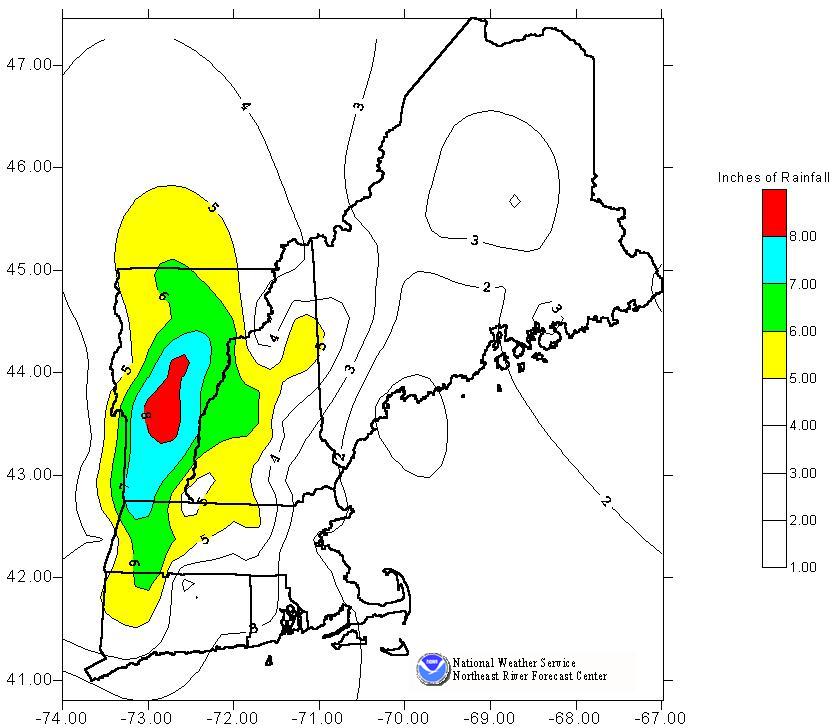
Rainfall during November 1927 flooding event in New England
References:
Kinnison, HB. 1929. The New England Flood of November, 1927. Water Supply Paper 636-C. United States Department of the Interior.
Holyoke Water Power Company, 1928. Connecticut River Flood at Holyoke, Massachusetts, November 5-6, 1927.
US Dept of Commerce
National Oceanic and Atmospheric Administration
National Weather Service
Northeast RFC
46 Commerce Way
Norton, MA 02766
(508) 622-3300
Comments? Questions? Please Contact Us.

