Northeast RFC
River Forecast Center
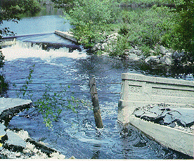 |
| Picture of flooding in East Lyme, CT during the June 1982 floods. |
The heaviest spring rainfall to impact Southern New England occurred tbe weekend of June 4-7, 1982. A large low pressure system moved up from the Gulf coast and moved slowly up to the northeast, stalling on June 5 positioned to dump large amounts of water over Connecticut, and the rest of southern New England. Up to 16 inches of rain fell in the region over a four day period, with the heaviest amounts occurring in south central Connecticut. Rainfall on Saturday June 5 accounted for over half of that total when up to 10 inches fell.
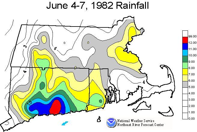 |
| Rainfall totals across Southern New England from June 4-7, 1982. |
Antecedent conditions of soil moisture and river levels were hampered by a storm the previous week which had left up to 4 inches of rain in many of the same areas.
The result of this rainfall was many floods and flash floods, primarily in Connecticut. Record floods occurred on many smaller streams through the central part of the state. The larger rivers in Connecticut, the Housatonic and Connecticut, were not greatly impacted as their headwaters in the more northern parts of New England were not impacted by heavy rain. However, the smaller rivers - Yantic, Farmington, Shetucket - all received significant flooding as well as many smaller streams.
One of the ironies of this event was that one of the facilities that was impacted was the Northeast River Forecast Center. The NERFC offices, which at that time were located in Bloomfield CT, were flooded for a day. Staff had to move to other locations including one home in order to complete their forecast responsibilities.
The floods caused the loss of at least eleven lives. In addition damage estimates of approximately 230 million dollars were incurred. Thousands of homes suffered varying degrees of damage.
One significant development from the aftermath of this flooding was the development of a statewide flood warning system under the mangement of the Connecticut Department of Environmental Protection. While this will not prevent flooding to occur in the future, it may help provide advance warning and prevent the loss of lives and property.
US Dept of Commerce
National Oceanic and Atmospheric Administration
National Weather Service
Northeast RFC
46 Commerce Way
Norton, MA 02766
(508) 622-3300
Comments? Questions? Please Contact Us.

