|
 |
|||
Satellites
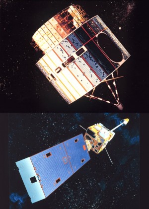
Evolution of satellites since the Fitzgerald Enormous advances have been made in the area of satellite meteorology since the tragic loss of the Edmund Fitzgerald on November 10, 1975. The satellite in use in 1975, the Synchronous Meteorological Satellite (SMS-1), had only two channels to view the earth (visible and infrared). By comparison, the modern-day GOES satellites have five imager channels. These channels can also be combined to help detect features such as fog and low clouds at night, an impossible task in 1975. Current GOES satellites have improved resolution of imagery by up to four times higher than what was available from the SMS-1 and early-generation GOES. GOES satellites also carry a sounder that views the atmosphere with 19 channels, while the SMS-1 lacked this capability. The GOES sounder allows the satellite to sense temperature and moisture through the depth of the atmosphere (similar to what land based weather balloon radiosondes do) and also to determine surface and cloud top temperatures as well as ozone distribution. Recent satellite advancements Not only have improvements been made in the ability of satellites to view the earth, but methods to deliver these images to forecasters and users have also improved dramatically since 1975. It was only as recently as the 1990s that the ability to view satellite imagery on desktop computers and workstations became widely available. The Advanced Weather Interactive Processing System (AWIPS), which was introduced to modernized National Weather Service forecast offices across the nation from 1997 - 1999 and recently upgraded to AWIPS2 from 2013-2015, allows forecasters to view multiple screens of satellite imagery along with other weather data. Meteorologists are also able to enhance satellite imagery to highlight significant patterns and animate the imagery on workstation monitors. This is a vast improvement from 1975 when meteorologists were generally limited to viewing black and white satellite images on paper copies. Some weather offices in 1975 received only a few of these satellite images per day. Current temporal resolution of satellite data into National Weather Service offices is typically one new image every 15 minutes. During rapid scan satellite mode in times of severe weather, satellite imagery is updated every 1-2 minutes.
|
||||
| Credits | Disclaimer | |
||||