
Thunderstorms and periods of heavy to excessive rainfall will continue over Florida through Thursday. Gusty winds and low humidity will promote elevated to critical fire weather conditions from central Georgia into north-central North Carolina Wednesday. A Kona Low is expected to bring strong winds, widespread heavy rainfall, and flooding concerns to the island chain through the weekend. Read More >
Overview
On June 15, a cold front moved across Upper Michigan resulting in widespread thunderstorms during the late afternoon and evening hours. Some of the thunderstorms were severe, especially those closer to the MI/WI border. Thunderstorms initially developed during the early afternoon hours over Minnesota and northeast Iowa. Thunderstorms entered western Upper Michigan between 4pm and 6pm EDT. Strong to severe thunderstorms over Wisconsin gradually congealed into broken line segments over northeast Wisconsin and moved into southeastern Upper Michigan around 8 pm EDT / 7pm CDT. Downed trees and powerlines were reported in areas of Menominee and Delta Counties with the worst damage from Faithorn to the Hermansville area where downed trees and powerlines resulted in impassable roads. Several structures were severely damaged and thousands of trees were downed. A survey by a team with the NWS concluded that the damage was characteristic of intense straight line winds of 100 to 110 mph. This is supported by radar data which showed a classic descending rear inflow jet (strong high altitude winds descending to the ground) surging northeastward across this area. In addition, the downed trees fell in mainly the same direction along with signs of divergent flow in the damage pattern. |
 Radar Reflectivity June 15, 2022 5pm to 11pm EDT |
Photos & Video
Header
| Areal footage of tree damage from the WI and MI sides of the Menominee River, near Faithorn. Credit: Upper Limits Media |
 |
 |
 |
|
Winds pulled the metal roof of an outbuilding in the Hermansville area Credit: Lynda Kae Gurgal |
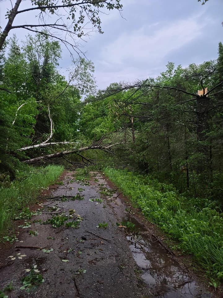
Trees down across drive in the Hermansville area Credit: Lynda Kae Gurgal |
Some of the many trees down in the Hermansville area Credit: Lynda Kae Gurgal |
 |
 |
 |
|
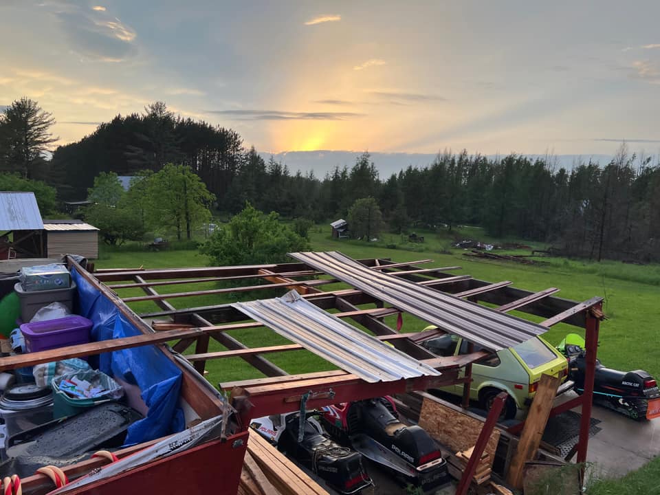
Damage to farm including vehicles and structures Credit: Tammy Kiser |
Wood lofted and stuck into siding of barn Credit: Tammy Kiser |
Wood lofted and stuck into side of vehicle Credit: Tammy Kiser |
Radar
 |
 |
 |
| At 702 PM CDT Radar Reflectivity shows a small notch forming (area of reduced reflectivity) on the southwest side of the thunderstorm complex over northeast WI | At 708 PM CDT Radar Reflectivity shows a large notch forming on southwest side of the thunderstorm complex indicative of a descending rear inflow jet (storm winds aloft descending into the rear of the storm) | At 714 PM CDT Radar Reflectivity continues to show a rear inflow jet co-located with the area of damage from Faithorn to Hermansville. |
Damage Path
Sentinal satellite data shows the tree damage near Faithorn. The reds in the imagery have been enhanced to help the scar stand out, which is outlined by the red polygon. Notice the streak of red shading within the polygon on June 17th due to the downed trees.
 |
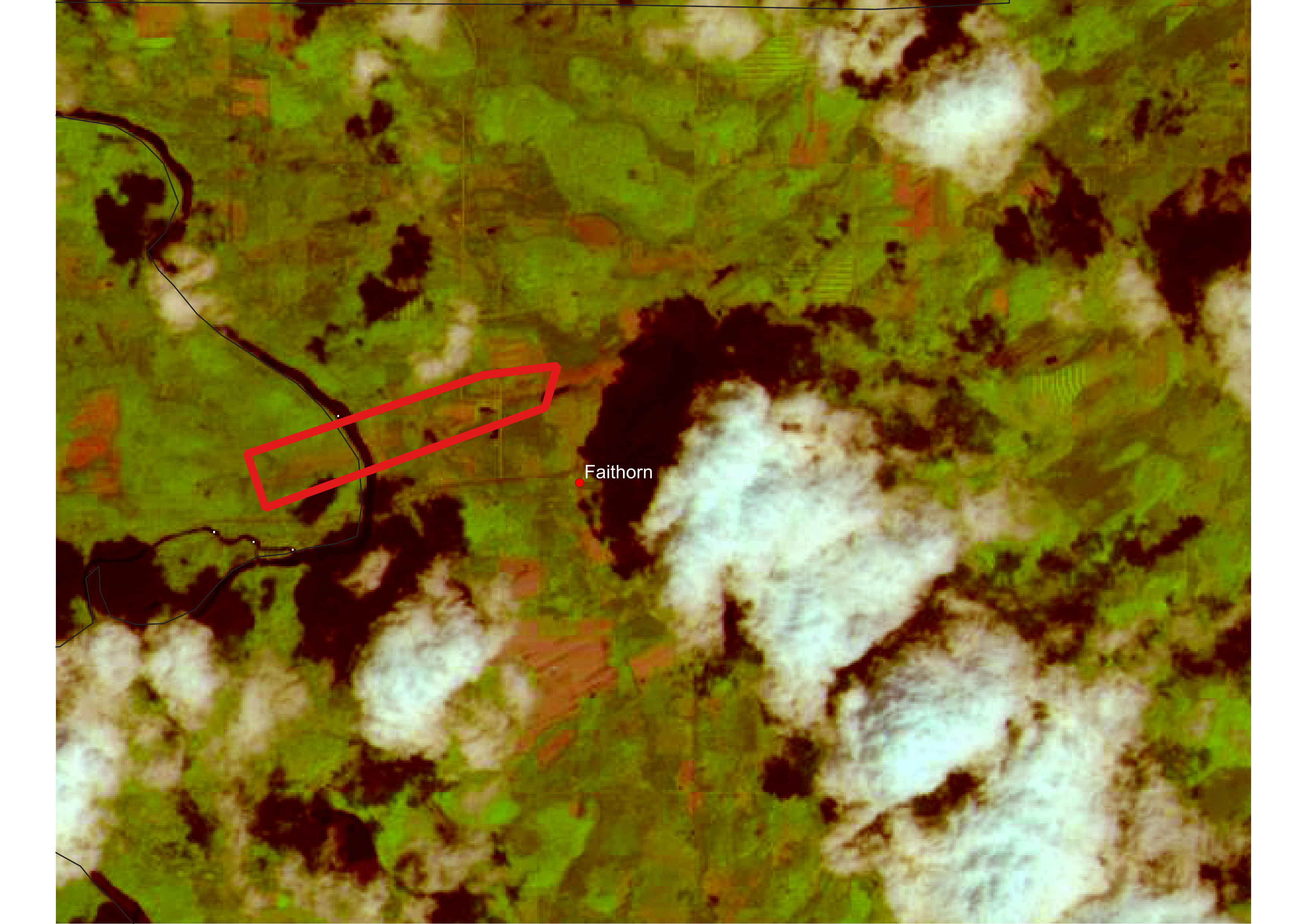 |
| Senintal Satellite Imagery from June 4, 2022 - before the storm damage | Senintal Satellite Imagery from June 17, 2022 - after the storm damage |
Environment
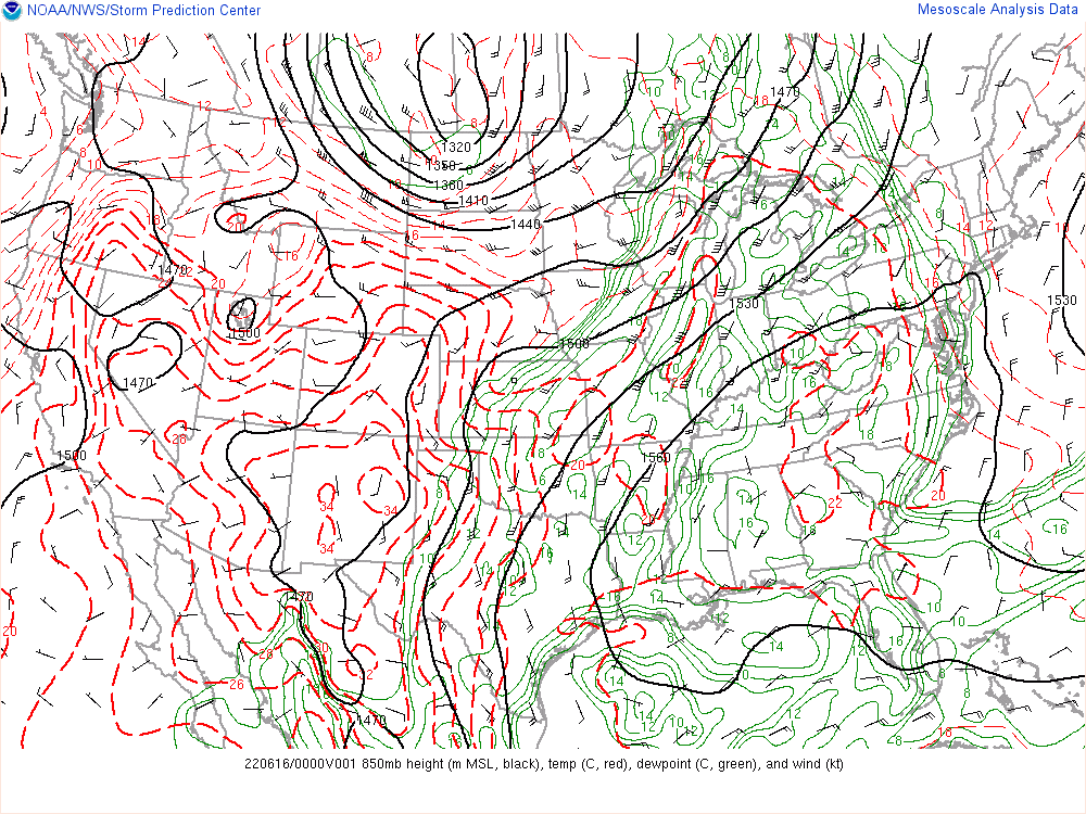
On the evening of June 15, 2022, an upper level trough was moving through the northern Plains and into the Great Lakes region. A strong upper level jet along with upper level divergence was over the Upper Peninsula, shown in Figure 1. Warm and moist air were being advected into the Upper Great Lakes from the Gulf of America with southerly flow in the low levels of the atmosphere shown in Figures 2 and 3. A cold front was also located over central Upper Michigan and northwest Wisconsin, providing a focus for thunderstorm development. The forward movement of the front helped to organize the thunderstorms into a line as it moved through eastern Upper Michigan.
 |
 |
 |
| Figure 1: 300mb - Wind (kt) and Divergence | Figure 2: 850mb - Wind (kt), Dewpoint (C) and Temp (C) | Figure 3: Surface - Mean Sea Level Pressure (mb), Temp (F), Dewpoint (F) and Wind (kt) |
Deep moisture and instability were in place over the Upper Great Lakes with the axis of greatest instability (Convective Available Potential Energy or CAPE) located over eastern WI, stretching north into Menominee County (Figure 1). In this area low level lapse rates were steep (Figure 3), which is the rate of cooling per km measured between the surface and 3 km. Steeper low level lapse rates, more rapid cooling with height, are indicative of greater instability. The area of steeper lapse rates is co-located with an axis of Downdraft CAPE (DCAPE) approaching 1000 J/kg (Figure 2), which is a measure of the potential strength of rain cooled downdrafts. These factors produced an environment favorable for severe thunderstorm wind gusts.
 |
 |
 |
| Figure 4: Most Unstable Cape and Effective Shear | Figure 5: Downdraft Cape | Figure 6: Low Level Lapse Rates (C/km) 0-3km |
 |
Media use of NWS Web News Stories is encouraged! Please acknowledge the NWS as the source of any news information accessed from this site. |
|

