National Weather Service United States Department of Commerce

Overview

On Monday evening July 11, 2016 thunderstorms produced three tornadoes across central Minnesota.  The National Weather Service in the Twin Cities sent out 3 storm survey crews to assess the damage.  As of Tuesday morning, there has been only one minor injury reported.

Based on the preliminary storm reports, areas hardest hit were the town of Watkins MN, northwest Litchfield MN, as well as locations near St Cloud MN. This part of the state is highlighted by the red box on the map to the right.  Further information is given below and additional facts about the strength of the tornadoes will be released as the become available.

The survey teams have completed their investigations.  See details below.


Image
The red box on the map above shows the area in Minnesota that had tornadoes.

Tornadoes:

Multiple tornadoes in central MN
Meeker and Stearns County

Date July 11, 2016
Location Central Minnesota

Summary:

Storm reports and radar show evidence of multiple tornadoes.  Several photos and videos of structural damage were received via social media.  A tornado damage track map will be created once survey crews gather information about the path length and width.  A peak EF rating will be given to each tornado based on the worst damage. 

Figure 2: The loop to the right shows radar reflectivity (left) and storm relative velocity (right) for 2 hours from 5 PM to 7 PM CDT.  The storm southwest of Litchfield showed rotation as it moved northeast toward St Cloud MN. 

Radar/Photo Radar/Photo Radar/Photo Radar/Photo
Rotation southwest of Litchfield. Radar reflectivity (left) and storm relative velocity (right) Strong rotation near Watkins. Radar reflectivity (left) and storm relative velocity (right) Radar indicated debris ball (blue circle) using Correlation Coefficient near Watkins Circulation near Cold Spring. Radar reflectivity (left) and storm relative velocity (right)

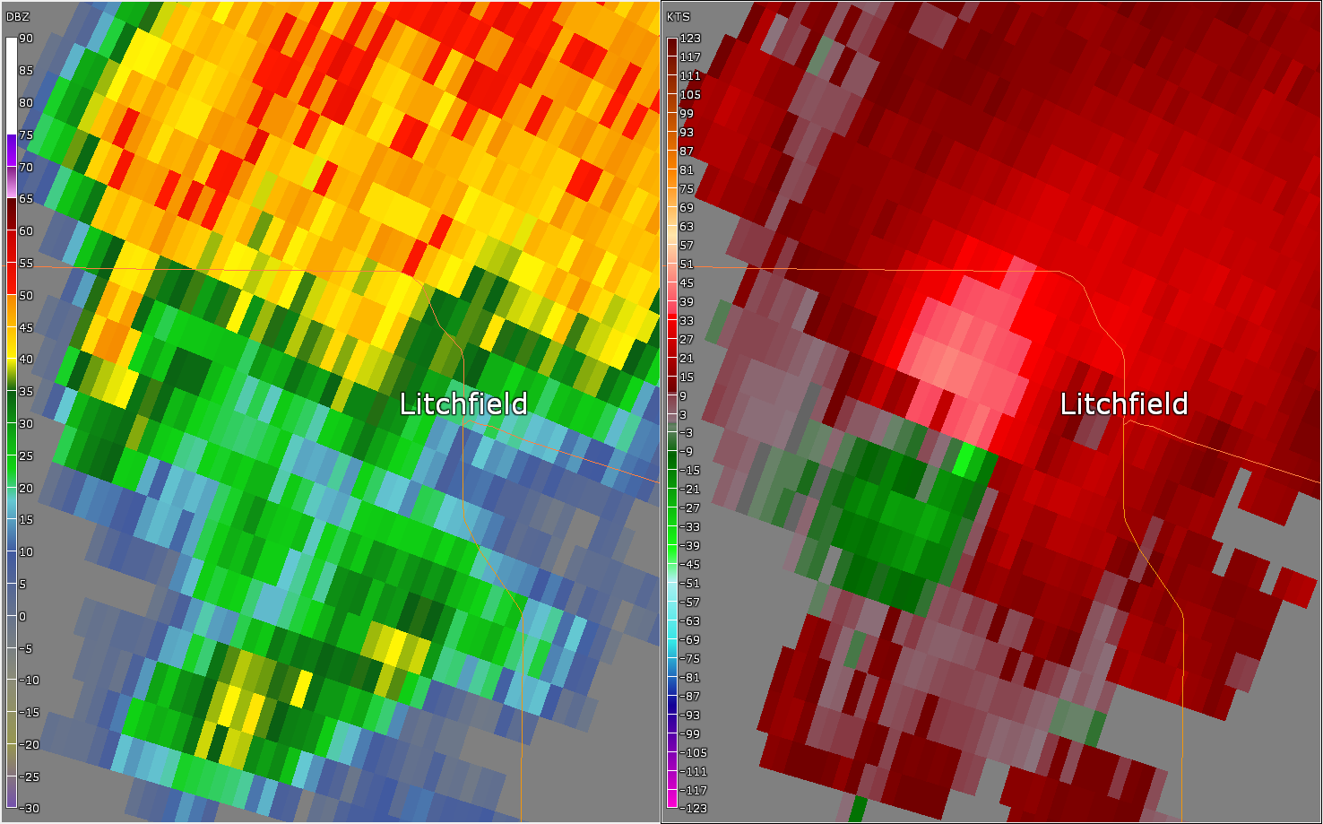
Tornado #1 - Litchfield, MN
COUNTY NAME

Date 7/11/2016
Time (Local) 5:25 PM - 5:32 PM CDT
EF Rating EF-2
Est. Peak Winds 115 MPH
Path Length 3.2 miles
Max Width 100 yards
Injuries/Deaths None

Summary:

This was a narrow tornado. There was a lot
of tree damage, though three single family 
homes received significant roof damage 
and a double wide manufactured home and
garage were flipped and rolled. Another garage
another garage and shed were destroyed near
Highway 12 on the north side of town.

Track Map

Track Map EF-Scale


Tornado #2 - Watkins, MN
COUNTY NAME

Date 7/11/2016
Time (Local) 5:52 PM - 5:56 PM CDT
EF Rating EF-2
Est. Peak Winds 125 MPH
Path Length 3.4 miles
Max Width 400 yards
Injuries/Deaths 1 injury

Summary:

The first significant damage was to a business 
along Highway 55 on the south side of town. 
The tornado then tracked across the highway 
and passed through the St. Anthony Cemetery 
before passing through the center of Watkins 
doing damage to structures and many trees. 
The most significant damage occurred between 
Stearns Ave and Meeker Ave where several 
homes had significant roof damage and had 
detached sheds and garages destroyed. The 
tornado exited the town and did further tree 
damage at a farmstead outside of town before 
lifting shortly thereafter.

Track Map

Track Map EF-Scale


Tornado #3 - Southern Stearns County
COUNTY NAME

Date 7/11/2016
Time (Local) 5:58 PM - 6:04 PM CDT
EF Rating EF-1
Est. Peak Winds 105 MPH
Path Length 4.2 miles
Max Width 250 yards
Injuries/Deaths None

Summary:

This tornado was spawned by the same 
storm that brought the tornado 
through Watkins. Multiple chaser videos 
showed the Watkins tornado lifted off the 
ground as it became occluded, with this 
tornadoes touchdown point made visible by 
the presence of corn laid down in the field 
south of the first homestead hit. This was 
about two-thirds of mile NNE of where the 
Watkins tornado lifted. At the first 
farmstead hit, two open air cattle sheds 
where completely destroyed, along with a 
metal storage shed and two mostly empty 
grain bins. There were two cattle killed at this 
location as well. This storm destroyed more 
outbuildings at a farmstead along 160th 
street, with the rest of the damage along 
the path of the tornado being corn laid 
flat and tree damage.

Track Map

Track Map EF-Scale


Tornado #4 - O'Neil Campground, WI
COUNTY NAME

Date 7/12/2016
Time (Local) 1:00 AM - 1:02 AM CDT
EF Rating EF-0
Est. Peak Winds 75 MPH
Path Length 0.4 miles
Max Width 150 yards
Injuries/Deaths None

Summary:

A short-lived EF-0 tornado touched down and caused tree damage in a campground and damaged the roof of a local business.

Track Map

Track Map EF-Scale


The Enhanced Fujita (EF) Scale classifies tornadoes into the following categories:

EF0
Weak

65-85 mph
EF1
Moderate
86-110 mph
EF2
Significant
111-135 mph
EF3
Severe
136-165 mph
EF4
Extreme
166-200 mph
EF5
Catastrophic
200+ mph
ef-scale

Photos:

Photo Photo Photo Photo
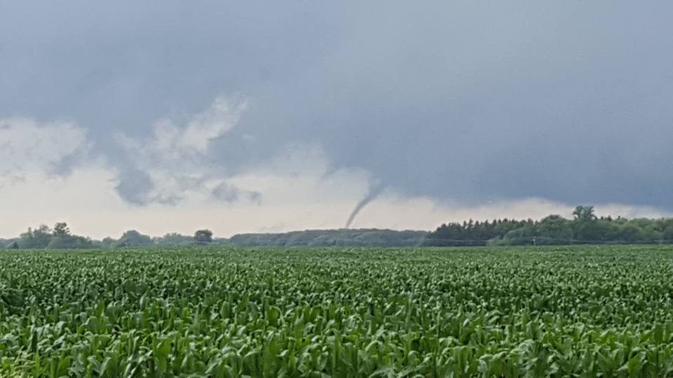
Tornado south of Litchfield (photo courtesy of Kevin Servin) Tornado roping out near Litchfield (photo courtesy of Kevin Servin) Damage to mobile home near Litchfield
(photo courtesy of Boyd Huppert, KARE)
Damage to shed near Litchfield
(photo courtesy of Boyd Huppert, KARE)


Environment

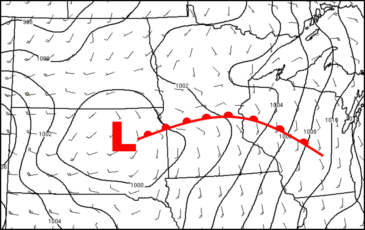
A surface low pressure system developed across the Dakotas, with a warm front extending eastward into central Minnesota.  A very unstable air mass formed south of the warm front. The wind fields along the warm front were favorable for rotating thunderstorms capable of producing tornadoes.  All images are as of 5 PM CDT, which is right before the tornadic thunderstorms developed.
 

Environment Observations 500 mb Map
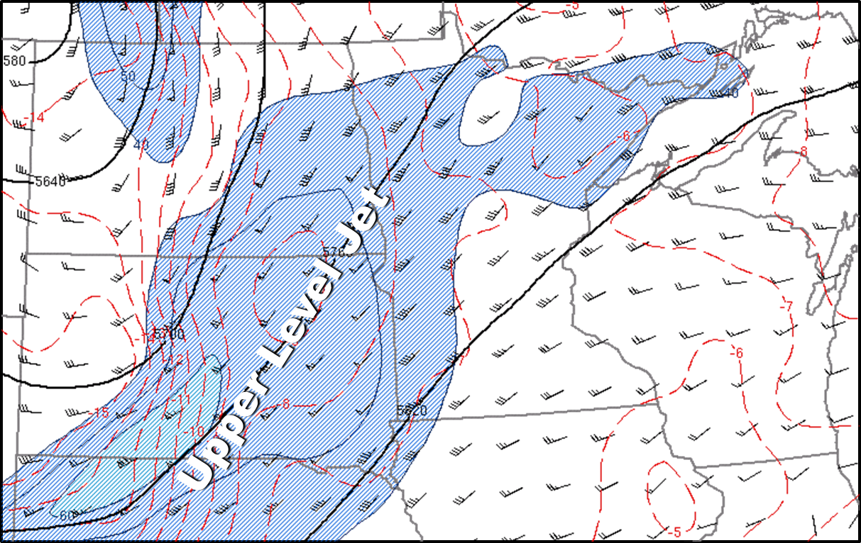
Figure 1: Surface map from Monday evening showing the warm front across central Minnesota. Figure 2: Observations showing a warm unstable airmass south of the warm front with highs in the upper 80s and dewpoints in the 70s. Figure 3: An upper level trough and wind max at 500 mb was moving across the region Monday evening.

The near storm environment was favorable for supercells, which are thunderstorms with rotating updrafts.  There was a lot of instability and deep layer wind shear.  The low level wind shear was also supportive of tornadoes.  
ML CAPE Effective Helicity Effective Significant Tornado Parameter
Figure 4: Mixed Layer CAPE measures instability in the atmosphere and potential for thunderstorms with strong updrafts. Figure 5: Effective Helicity looks at the wind fields in the low levels of the atmosphere and measures the potential for rotating updrafts. Figure 6: The image above shows the Significant Tornado Parameter. It combines the potential for strong updrafts together with the potential for rotating updrafts.  This indicated there was a high chance for tornadoes in central MN.
 
nws logo Media use of NWS Web News Stories is encouraged!
Please acknowledge the NWS as the source of any news information accessed from this site.
nws logo