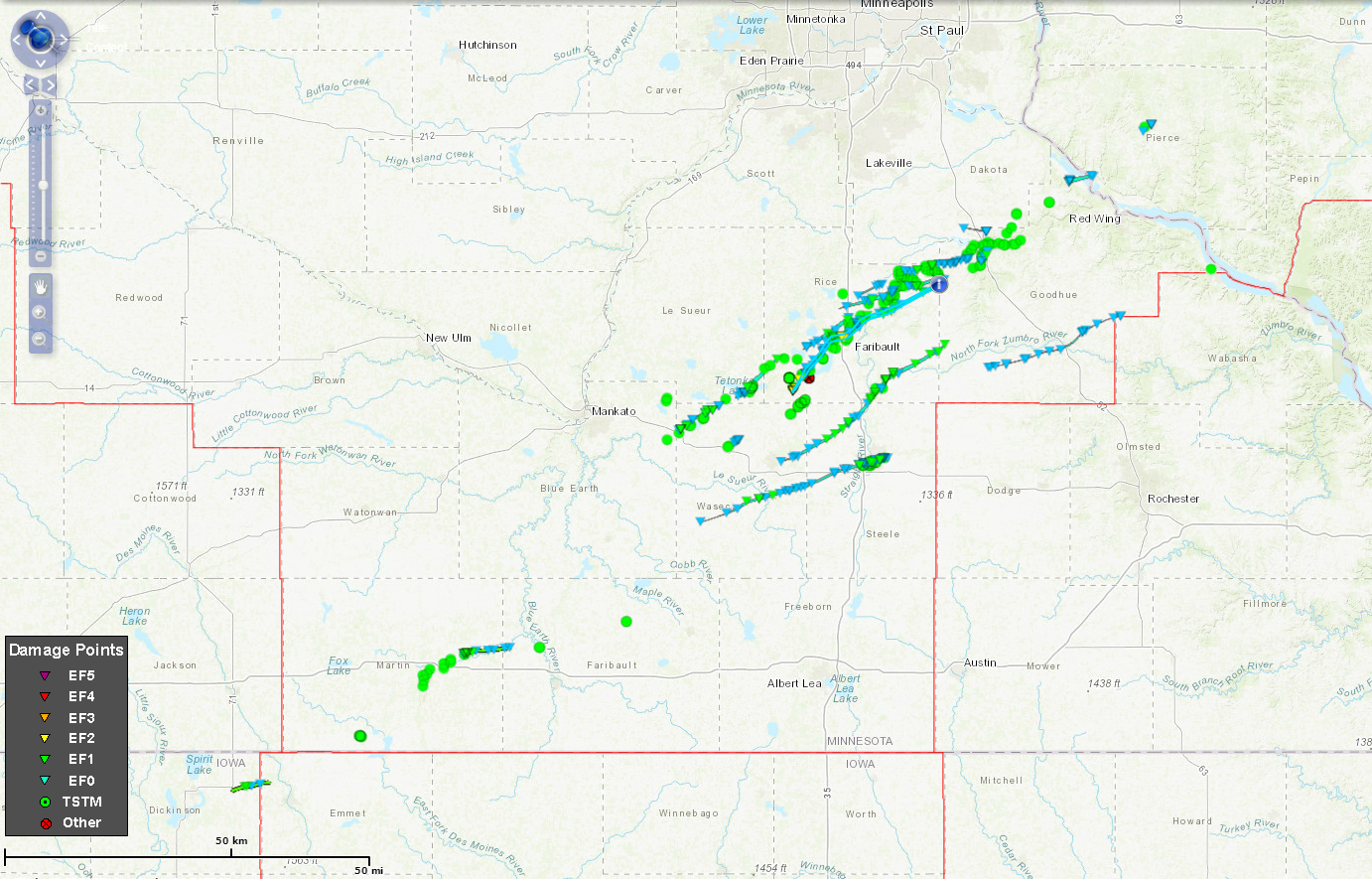
The image above shows all the tornadoes that occurred on September 20. Each triangle does not indicate a new tornado, just a damage point. The circles indicate wind damage. The polygons are the tornado tracks. Zoomed in images will be available for each tornado in the coming days as the website is updated.
Public Information Statement
National Weather Service Twin Cities/Chanhassen MN
413 PM CDT Fri Sep 28 2018

...NWS DAMAGE SURVEY FOR 09/20/2018 TORNADO EVENT - UPDATE 2...
...TORNADO COUNT STANDS AT 16...

.Update...Following several ground surveys; utilizing high
resolution satellite and radar imagery; speaking with local
officials, trained spotters, and the general public; and drone and
aerial footage it appears there were 16 tornadoes from southern
to eastern Minnesota and west central Wisconsin on September 20
2018. This information may be updated as new data becomes
available.

The difficulty with surveying this event was due in part to many
potential tornado tracks amongst widespread wind damage. Since the
storms were racing east northeastward around 65 mph, many of the
typical indicators for differentiating tornado versus straight
line wind damage were not available (e.g. debris deposited
westward), particularly across Rice County. Instead, there were
areas of enhanced damage on the southern end of the tornado track,
with little damage to the north. Most of the damage was to trees,
although there were pockets of significant structural damage.

Survey teams received numerous accounts of survivors seeking
shelter immediately after receiving the Tornado Warning via a
Wireless Emergency Alert notification. Some of these people later
had their house or other structure significantly damaged or
destroyed. It is of the opinion of the surveyors that this was one
big factor for the lack of fatalities or injuries.

The NWS would like to thank all the spotters, local officials,
broadcast television, local media, volunteer and media drone
operators, and citizens that contributed to the sharing of
information before, during, and after the event.

Overall, there were six EF0s, nine EF1s, and one EF2.

.Granada, MN Tornado...

Rating:                 EF1
Estimated peak wind:    95 to 105 mph
Path length /Statute/:  6.5 miles
Path width /Maximum/:   220 yards
Fatalities:             0
Injuries:               0

Start date:             Sep_20_2018
Start time:             552 PM CDT
Start location:         1 N Granada
Start Lat/Lon:          43.6981 / -94.3531

End date:               Sep_20_2018
End time:               559 PM CDT
End location:           7 NE Blue Earth
End_lat/lon:            43.7095 / -94.2240

Video and ground survey confirmed a tornado just north of Granada
which tracked to the east.

.Lake Elysian, MN Tornado...

Rating:                 EF1
Estimated peak wind:    95 to 105 mph
Path length /Statute/:  6.8 miles
Path width /Maximum/:   200 yards
Fatalities:             0
Injuries:               0

Start date:             Sep_20_2018
Start time:             619 PM CDT
Start location:         3 NE Janesville MN
Start Lat/Lon:          44.1428 / -93.7562

End date:               Sep_20_2018
End time:               624 PM CDT
End location:           2 ESE Elysian
End_lat/lon:            44.1916 / -93.6449

Ground survey and radar data confirmed tornado along the southeast
shore of Lake Elysian.

.Janesville, MN (east) Tornado...

Rating:                 EF0
Estimated peak wind:    65 to 75 mph
Path length /Statute/:  0.8 miles
Path width /Maximum/:   20 yards
Fatalities:             0
Injuries:               0

Start date:             Sep_20_2018
Start time:             622 PM CDT
Start location:         5 E Janesville
Start Lat/Lon:          44.1186 / -93.6027

End date:               Sep_20_2018
End time:               623 PM CDT
End location:           6 E Janesville
End_lat/lon:            44.1243 / -93.5902

Satellite data and ground survey confirmed narrow track through corn
east of Janesville.

.Owatonna, MN Tornado...

Rating:                 EF1
Estimated peak wind:    95 to 105 mph
Path length /Statute/:  27.0 miles
Path width /Maximum/:   200 yards
Fatalities:             0
Injuries:               0

Start date:             Sep_20_2018
Start time:             623 PM CDT
Start location:         2 N Waldorf
Start Lat/Lon:          43.9609 / -93.6973

End date:               Sep_20_2018
End time:               642 PM CDT
End location:           3 E Owatonna
End_lat/lon:            44.0879 / -93.1786

Satellite data and ground survey confirmed tornado that formed north
of Waldorf and tracked through Owatonna before dissipating east of
town.

.Waterville, MN Tornado...

Rating:                 EF1
Estimated peak wind:    90 to 100 mph
Path length /Statute/:  7.7 miles
Path width /Maximum/:   500 yards
Fatalities:             0
Injuries:               0

Start date:             Sep_20_2018
Start time:             626 PM CDT
Start location:         2 SW Waterville
Start Lat/Lon:          44.2106 / -93.5927

End date:               Sep_20_2018
End time:               632 PM CDT
End location:           1 SW Caron Lake
End_lat/lon:            44.2838 / -93.4849

Radar data, ground survey, and cell phone video confirmed tornado through
Waterville MN. Most of the damage on Upper Sakatah Lake was from storm
inflow accelerating across the water and damaging the trees and structures
along the north shoreline.

.Medford, MN Tornado...

Rating:                 EF1
Estimated peak wind:    100 to 110 mph
Path length /Statute/:  27.8 miles
Path width /Maximum/:   500 yards
Fatalities:             0
Injuries:               0

Start date:             Sep_20_2018
Start time:             630 PM CDT
Start location:         1 E Waseca
Start Lat/Lon:          44.0804 / -93.4741

End date:               Sep_20_2018
End time:               652 PM CDT
End location:           2 SE Nerstrand
End_lat/lon:            44.3127 / -93.0205

Satellite imagery, radar, and ground survey confirmed tornado from just
east of Waseca through northern Medford and ending near Nerstrand.
Several farmsteads were heavily damaged or destroyed.

.Morristown/Faribault, MN Tornado...

Rating:                 EF2
Estimated peak wind:    120 to 130 mph
Path length /Statute/:  25.8 miles
Path width /Maximum/:   1000 yards
Fatalities:             0
Injuries:               0

Start date:             Sep_20_2018
Start time:             632 PM CDT
Start location:         Morristown
Start Lat/Lon:          44.2202 / -93.4400

End date:               Sep_20_2018
End time: 654 PM CDT
End location: 2 N Dennison
End_lat/lon: 44.4408 / -93.0219

This was the strongest of all the tornadoes. Winds of 120 to 130
mph hit southern Morristown and destroyed several homes. This
tornado continued through northern Faribault and destroyed several
buildings at the airport. The path beyond Faribault is more
uncertain with widespread wind damage and other potential tracks
complicating the survey.

.Faribault, MN (west & north) Tornado...

Rating:                 EF1
Estimated peak wind:    90 to 100 mph
Path length /Statute/:  7.7 miles
Path width /Maximum/:   400 yards
Fatalities:             0
Injuries:               0

Start date:             Sep_20_2018
Start time:             638 PM CDT
Start location:         Cedar Lake
Start Lat/Lon:          44.3067 / -93.4033

End date:               Sep_20_2018
End time:               644 PM CDT
End location:           4 N Faribault
End_lat/lon:            44.3658 / -93.2875

Another area of enhanced damage occurred from Cedar Lake up through north
of Faribault. Radar showed and area of broad rotation from Faribault up
through Northfield.

.Dundas, MN (south) Tornado...

Rating:                 EF1
Estimated peak wind:    85 to 95 mph
Path length /Statute/:  14.3 miles
Path width /Maximum/:   400 yards
Fatalities:             0
Injuries:               0

Start date:             Sep_20_2018
Start time:             643 PM CDT
Start location:         5 N Faribault
Start Lat/Lon:          44.3873 / -93.2934

End date:               Sep_20_2018
End time:               657 PM CDT
End location:           2 N Dennison
End_lat/lon:            44.4431 / -93.0384

Another area of enhanced damage north of Faribault. Radar showed an area of
broad rotation from Faribault up through Northfield. Storm survey
indicated rotation and tornadic damage, but this was complicated by the
widespread wind damage and potential for multiple circulations.

.Dundas, MN Tornado...

Rating:                 EF0
Estimated peak wind:    70 to 80 mph
Path length /Statute/:  3.8 miles
Path width /Maximum/:   50 yards
Fatalities:             0
Injuries:               0

Start date:             Sep_20_2018
Start time:             648 PM CDT
Start location:         3 SW Dundas
Start Lat/Lon:          44.4088 / -93.2603

End date:               Sep_20_2018
End time:               650 PM CDT
End location:           Dundas
End_lat/lon:            44.4318 / -93.1945

Radar showed two brief couplets forming southwest of Dundas. Storm survey
indicated rotation and tornadic damage, but this was complicated by the
widespread wind damage and potential for multiple circulations.

.Northfield, MN Tornado...

Rating:                 EF1
Estimated peak wind:    100 to 110 mph
Path length /Statute/:  8.9 miles
Path width /Maximum/:   400 yards
Fatalities:             0
Injuries:               0

Start date:             Sep_20_2018
Start time:             653 PM CDT
Start location:         2 E Northfield
Start Lat/Lon:          44.4583 / -93.1291

End date:               Sep_20_2018
End time:               701 PM CDT
End location:           2 S Lake Byllesby
End_lat/lon:            44.4821 / -92.9548

Higher end damage along a concentrated path south of Hwy 19. Radar showed
an area of broad rotation.

.Wanamingo/Zumbrota, MN Tornado...

Rating:                 EF0
Estimated peak wind:    70 to 80 mph
Path length /Statute/:  19.4 miles
Path width /Maximum/:   250 yards
Fatalities:             0
Injuries:               0

Start date:             Sep_20_2018
Start time:             656 PM CDT
Start location:         6 SW Wanamingo
Start Lat/Lon:          44.2672 / -92.9006

End date:               Sep_20_2018
End time:               715 PM CDT
End location:           2 SW Bellechester
End_lat/lon:            44.3690 / -92.5344

Satellite, radar data, and ground survey confirmed 10 mile track south
of Wanamingo. Most of the damage was in the corn field.

.Cannon Falls, MN (south) Tornado...

Rating:                 EF1
Estimated peak wind:    85 to 95 mph
Path length /Statute/:  1.7 miles
Path width /Maximum/:   100 yards
Fatalities:             0
Injuries:               0

Start date:             Sep_20_2018
Start time:             701 PM CDT
Start location:         3 S Cannon Falls
Start Lat/Lon:          44.4777 / -92.9197

End date:               Sep_20_2018
End time:               703 PM CDT
End location:           1 S Cannon Falls
End_lat/lon:            44.4962 / -92.9031

Storm survey showed brief track in southern Cannon Falls.

.Cannon Falls, MN (north) Tornado...

Rating:                 EF0
Estimated peak wind:    70 to 80 mph
Path length /Statute/:  3.5 miles
Path width /Maximum/:   100 yards
Fatalities:             0
Injuries:               0

Start date:             Sep_20_2018
Start time:             702 PM CDT
Start location:         4 NW Cannon Falls
Start Lat/Lon:          44.5419 / -92.9688

End date:               Sep_20_2018
End time:               705 PM CDT
End location:           2 N Cannon Falls
End_lat/lon:            44.5351 / -92.9076

Satellite data showed narrow track northwest of town, and ground survey
confirmed damage near Hwy 20 north of town.

.Prairie Island, MN to Diamond Bluff, WI Tornado...

Rating:                 EF0
Estimated peak wind:    65 to 75 mph
Path length /Statute/:  3.9 miles
Path width /Maximum/:   200 yards
Fatalities:             0
Injuries:               0

Start date:             Sep_20_2018
Start time:             717 PM CDT
Start location:         Prairie Island
Start Lat/Lon:          44.6337 / -92.6776

End date:               Sep_20_2018
End time:               720 PM CDT
End location:           1 SE Diamond Bluff
End_lat/lon:            44.6445 / -92.6100

Storm survey identified brief area of tornadic damage near Prairie
Island across the Mississippi River to south of Diamond Bluff.

.Ellsworth, WI Tornado...

Rating:                 EF0
Estimated peak wind:    70 to 80 mph
Path length /Statute/:  1.7 miles
Path width /Maximum/:   25 yards
Fatalities:             0
Injuries:               0

Start date:             Sep_20_2018
Start time:             726 PM CDT
Start location:         1 E Ellsworth
Start Lat/Lon:          44.7328 / -92.4720

End date:               Sep_20_2018
End time:               728 PM CDT
End location:           2 NE Ellsworth
End_lat/lon:            44.7470 / -92.4489

SURVEY_SUMMARY:
NWS Twin Cities utilized radar data, cell phone and drone video,
ground survey information, satellite imagery, and spotter reports
to classify the damage. Areas near Faribault, Northfield, and
Cannon Falls were the most uncertain. This information will continue
to be modified as new data becomes available.

EF Scale: The Enhanced Fujita Scale classifies tornadoes into the
following categories.

EF0...Weak......65 to 85 mph
EF1...Weak......86 to 110 mph
EF2...Strong....111 to 135 mph
EF3...Strong....136 to 165 mph
EF4...Violent...166 To 200 mph
EF5...Violent...>200 mph

NOTE:
The information in this statement is PRELIMINARY and subject to
change pending final review of the event and publication in
NWS Storm Data.

$$

NWS Twin Cities

