Overview
|
Catastrophic flooding occurred across parts of Minnesota in mid-June 2024 as a stationary boundary stalled out across the Upper Midwest. On On June 16, widespread 3 to 5 inches of rain fell across northern Minnesota. Please see the NWS Duluth writeup for additional information. On June 19-21, several rounds of thunderstorms developed and tracked along this boundary, producing widespread 4 to 6 inches of rain across southern Minnesota, with some locations picking up 8 to 10 inches of rain. Please see NWS Sioux Falls, NWS Des Moines, and NWS La Crosse writeup for additional information. |
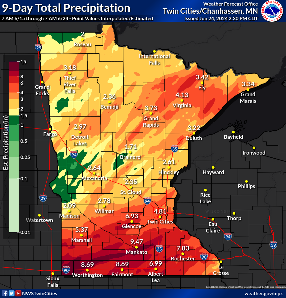 9-Day Total Accumulated Rainfall (Click to enlarge image) |
Flooding
Add a written summary if needed.
Observed Rainfall Totals
 |
 |
 |
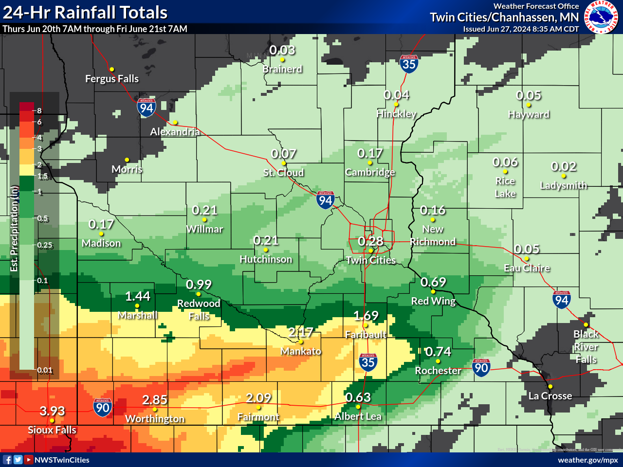 |
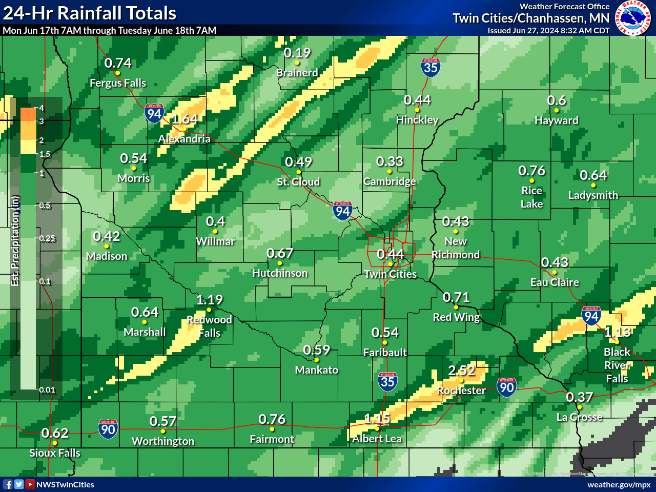
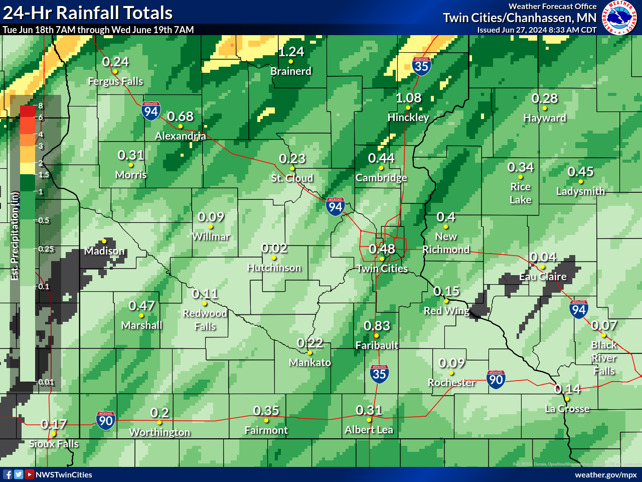
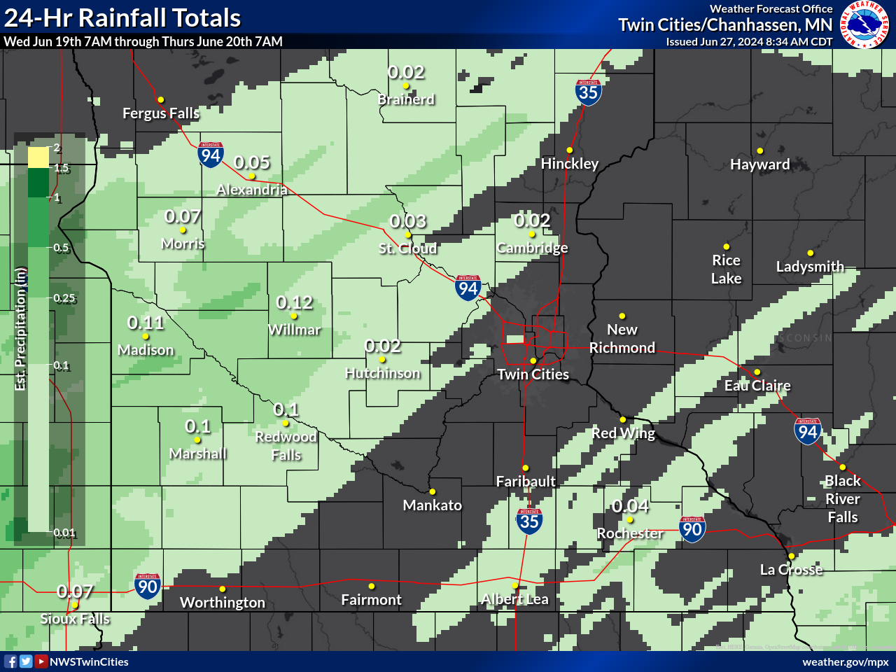
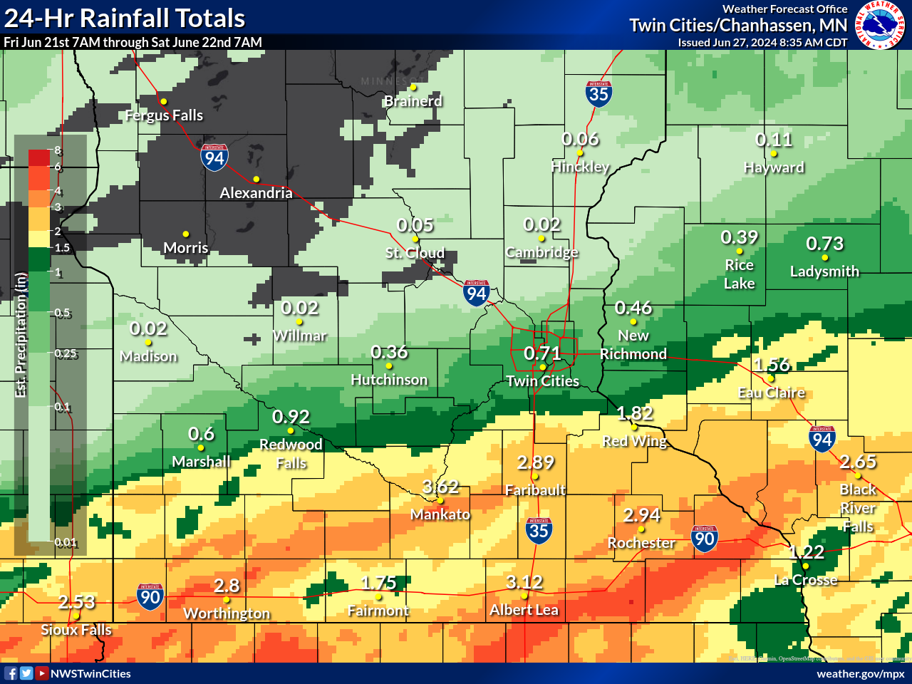
| Observed Rainfall Totals 7 AM June 17th to 7 AM June 18th | Observed Rainfall Totals 7 AM June 18th to 7 AM June 19th | Observed Rainfall Totals 7 AM June 19th to 7 AM June 20th | Observed Rainfall Totals 7 AM June 20th to 7 AM June 21st |
 |
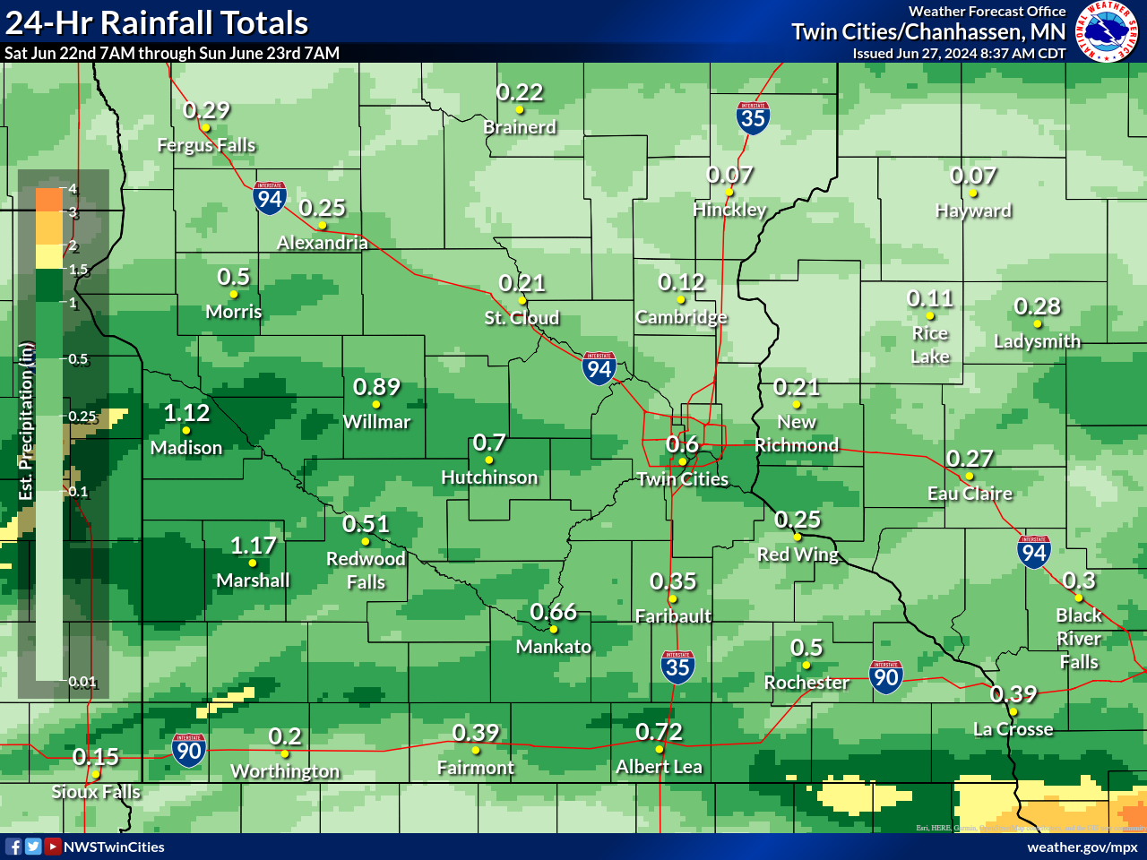 |
| Observed Rainfall Totals 7 AM June 21st to 7 AM June 22nd | Observed Rainfall Totals 7 AM June 22nd to 7 AM June 23rd |
Hydrographs
 |
 |
 |
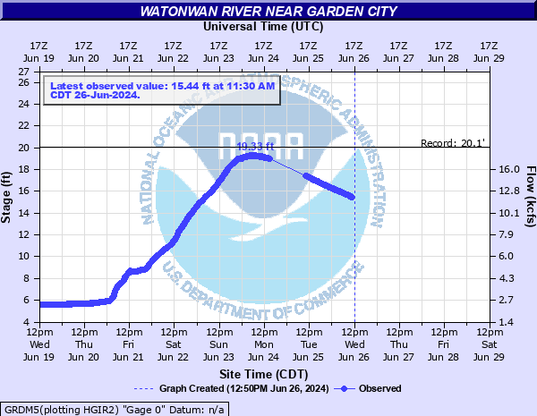 |
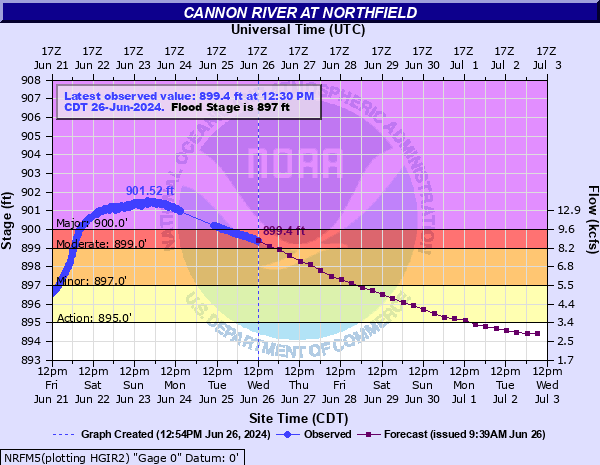
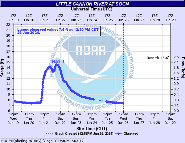
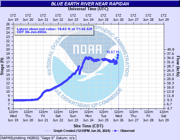
| Cannon River at Northfield crested above major flood stage on June 23. | The Little Cannon River at Sogn crested near a record on June 22. | The Blue Earth River near Rapidan rose above 18 feet, overtopping the Rapidan Dam. | The Watonwan River near Garden City crested just below a record on June 23. |
 |
 |
 |
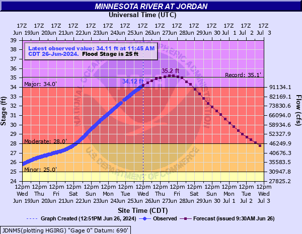 |
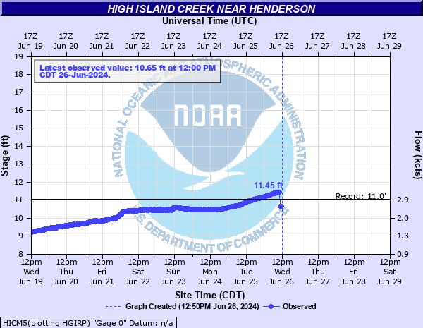
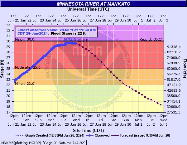
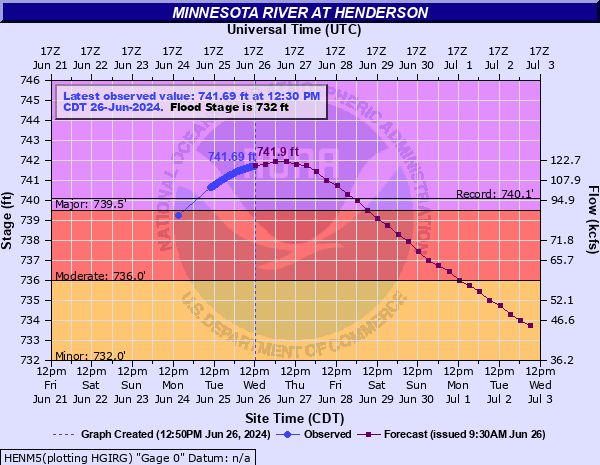
| The High Island Creek near Henderson crested near 11.5 feet on June 26, breaking the previous record. | The Minnesota River at Mankato crested just shy of the record set back in 1993. | As of June 26, the Minnesota River at Henderson had risen above the previous record set back in 1965. | As of June 26, the Minnesota River at Jordan was forecast to crest above the record. |
Impacts
 |
|||
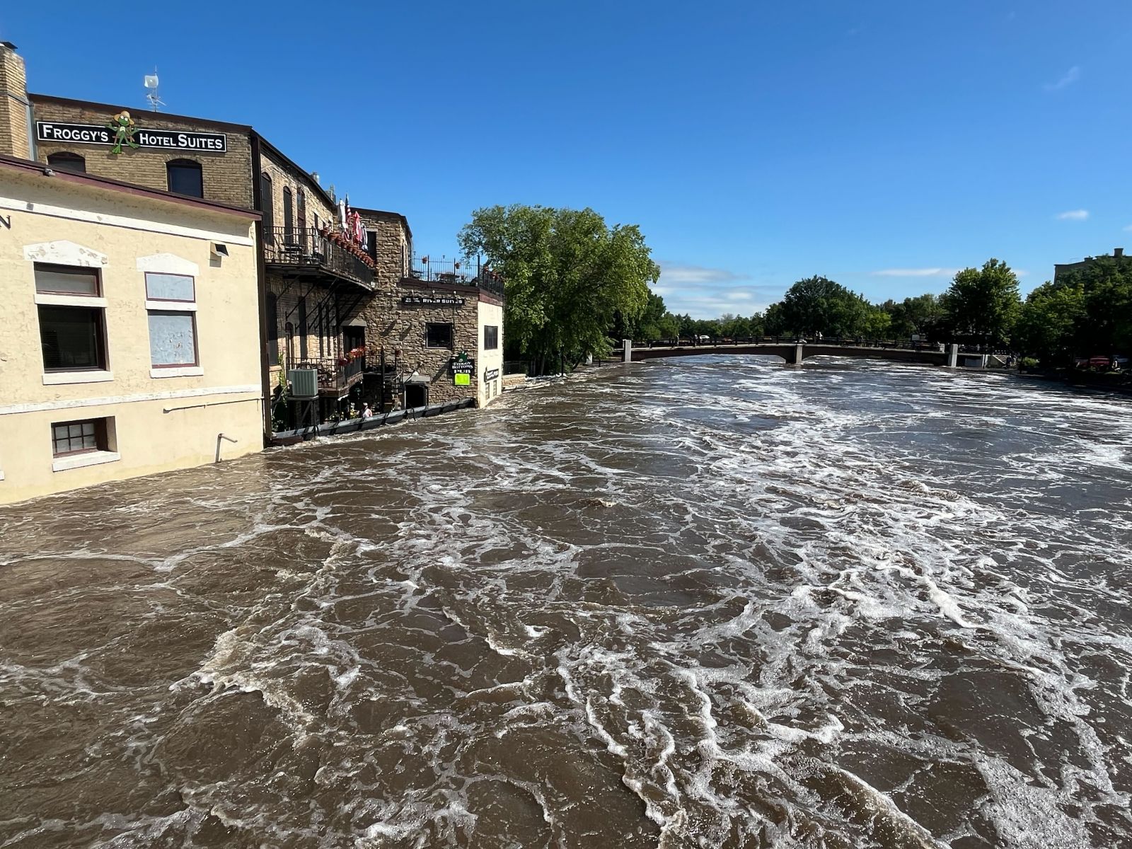
| The Cannon River impacted Northfield MN. | Caption | Caption | Caption |
Photos & Video
Header
| Caption (source) |
Caption (source) |
Caption (source) |
Caption (source) |
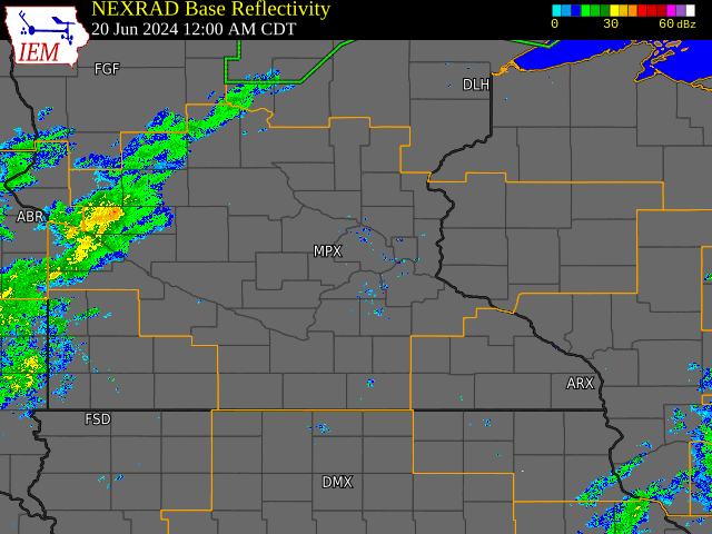
Radar
 |
Storm Reports
NOUS43 KMPX 221608
PNSMPX
MNZ041>045-047>070-073>078-082>085-091>093-WIZ014>016-023>028-230408-

Public Information Statement
National Weather Service Twin Cities/Chanhassen MN
1108 AM CDT Sat Jun 22 2024

...3-DAY PRECIPITATION REPORTS FROM JUNE 19-22, 2024...

Location                     Amount    Time/Date       Lat/Lon
Skyline 2ESE                 8.10 in   0700 AM 06/22   44.13N/93.99W
4.2 SW Skyline               7.17 in   1035 AM 06/22   44.10N/94.10W
Saint James 0.5 SSW          6.99 in   0700 AM 06/22   43.98N/94.63W
Janesville 5.4 NNE           6.45 in   0826 AM 06/22   44.19N/93.65W
Waterville 0.4 NE            5.81 in   0600 AM 06/22   44.23N/93.57W
North Mankato 1.3 ESE        5.71 in   0700 AM 06/22   44.17N/94.01W
Waseca 7.9 N                 5.35 in   0700 AM 06/22   44.20N/93.48W
Faribault 0.7 SW             4.91 in   0800 AM 06/22   44.29N/93.29W
Faribault                    4.84 in   0700 AM 06/22   44.31N/93.27W
Truman 0.7 WNW               4.49 in   0700 AM 06/22   43.83N/94.45W
Albert Lea 3.4 SSE           4.22 in   0705 AM 06/22   43.61N/93.33W
Hope                         4.19 in   1049 AM 06/22   43.97N/93.37W
Owatonna 1.5 N               4.07 in   0700 AM 06/22   44.11N/93.22W
Dennison 4.2 E               4.06 in   0700 AM 06/22   44.40N/92.96W
Comfrey 5.2 E                3.99 in   0730 AM 06/22   44.11N/94.80W
Nerstrand 4E                 3.94 in   0700 AM 06/22   44.34N/92.98W
4.2 S Glenville              3.89 in   1000 AM 06/22   43.51N/93.27W
Blue Earth 0.6 ESE           3.85 in   0700 AM 06/22   43.64N/94.09W
Kenyon 0.4 SSW               3.83 in   0830 AM 06/22   44.27N/92.99W
Fairmont 0.9 SE              3.81 in   0700 AM 06/22   43.63N/94.45W
New Ulm 1.0 S                3.72 in   0700 AM 06/22   44.30N/94.47W
Stockholm 2NE                3.36 in   0800 AM 06/22   44.52N/92.22W
Eau Claire                   3.36 in   1038 AM 06/22   44.75N/91.55W
St. Peter 6WSW               3.30 in   0700 AM 06/22   44.29N/94.08W
Fairmont AP                  3.28 in   0956 AM 06/22   43.63N/94.42W
Northfield 1.8 NNE           3.08 in   0700 AM 06/22   44.48N/93.15W
1.1 NE Lamberton             2.75 in   1030 AM 06/22   44.24N/95.25W
3.1 SE Cobden                2.74 in   1045 AM 06/22   44.25N/94.81W
Red Wing 3SE                 2.62 in   0700 AM 06/22   44.55N/92.56W
Randolph 4.1 E               2.53 in   0800 AM 06/22   44.54N/92.94W
Durand 2W                    2.41 in   0615 AM 06/22   44.62N/92.02W
Maiden Rock 1.8 WNW          2.41 in   0800 AM 06/22   44.58N/92.34W
Gibbon                       2.20 in   1045 AM 06/22   44.56N/94.51W
Eleva 5.3 NW                 2.18 in   0610 AM 06/22   44.64N/91.53W
Jim Falls 3NW                2.02 in   0730 AM 06/22   45.08N/91.33W
Downsville 6E                1.79 in   0700 AM 06/22   44.76N/91.80W
6 N Veseli                   1.78 in   0700 AM 06/22   44.61N/93.46W
Jordan 4.2 SSE               1.75 in   0800 AM 06/22   44.61N/93.60W
Elk Mound 1ENE               1.69 in   0700 AM 06/22   44.89N/91.67W
Burnsville 3SSW              1.67 in   0700 AM 06/22   44.72N/93.29W
Baldwin                      1.66 in   0700 AM 06/22   44.98N/92.37W
Prior Lake 1ESE              1.64 in   0800 AM 06/22   44.71N/93.40W
Winthrop 0.6 NNE             1.62 in   0624 AM 06/22   44.55N/94.36W

Observations are collected from a variety of sources with varying
equipment and exposures. We thank all volunteer weather observers
for their dedication. Not all data listed are considered official.

$$
 |
Media use of NWS Web News Stories is encouraged! Please acknowledge the NWS as the source of any news information accessed from this site. |
|

