Overview
|
On March 19, 2025, a narrow band of heavy snow brought blizzard conditions from Nebraska up through southern Minnesota. This was a wet, heavy snow, with snowfall rates of 1 to 2 inches per hour leading to near zero visibility at times. Wind gusts were 35 to 40 mph, and snowfall amounts of 6 to 9 inches were observed across far southern Minnesota. One thing to note is this was a classic spring system, in the sense that it had thunderstorms and severe weather on the warm side across Iowa and Illinois, with a band of heavy snow and a very sharp cutoff on the cold side. |
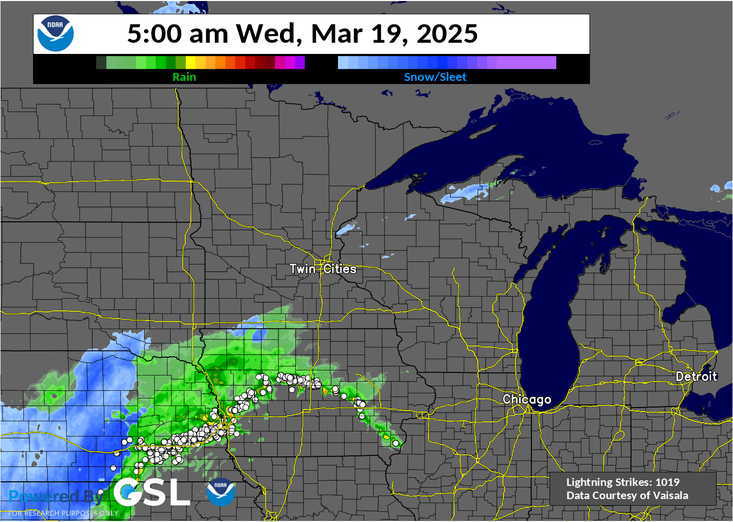 16 hour radar loop and precipitation type with lighting overlaid (white dotes) from the March 19 winter storm. Rain (green/yellow) changed over to snow (blue) Wednesday morning across southern Minnesota. The heaviest snow fell across far southern Minnesota and northern Iowa. |
 |
 |
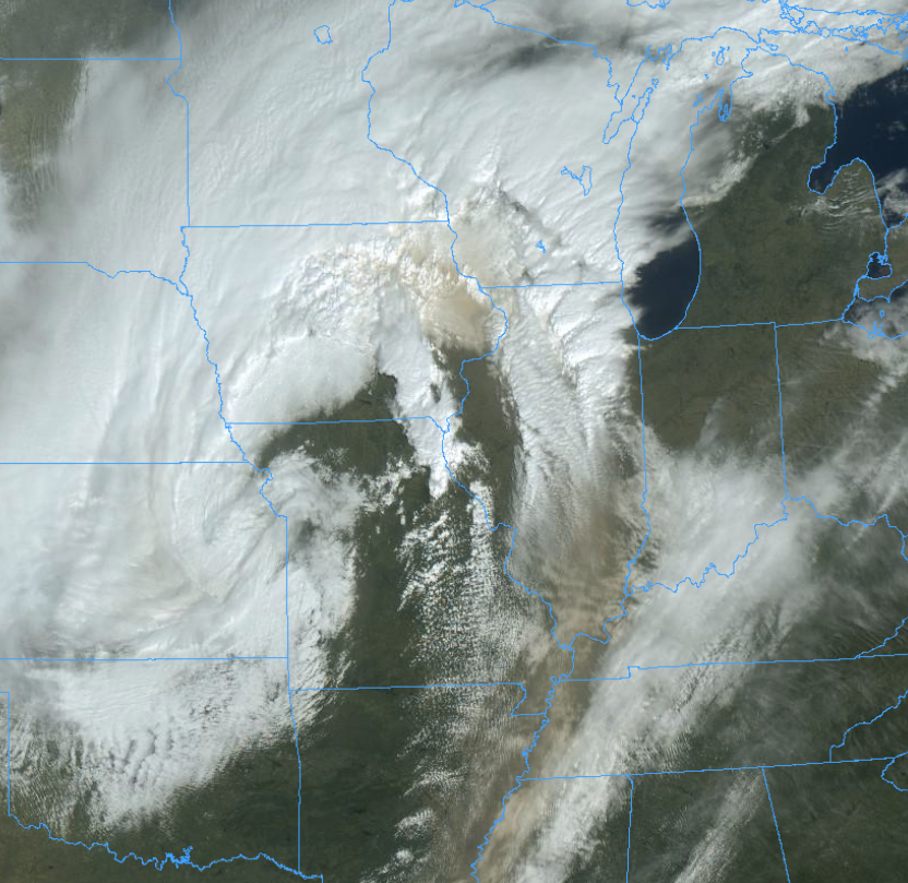
| Visible satellite imagery from March 20, 2025 that showed the narrow band of snow (white strip) corresponding to the snowfall map on the right. | Road conditions as of 3 AM on March 05, 2025. The extensive travel impacts were seen from Missouri and Kansas, up through northern Minnesota and Wisconsin. |
Summary
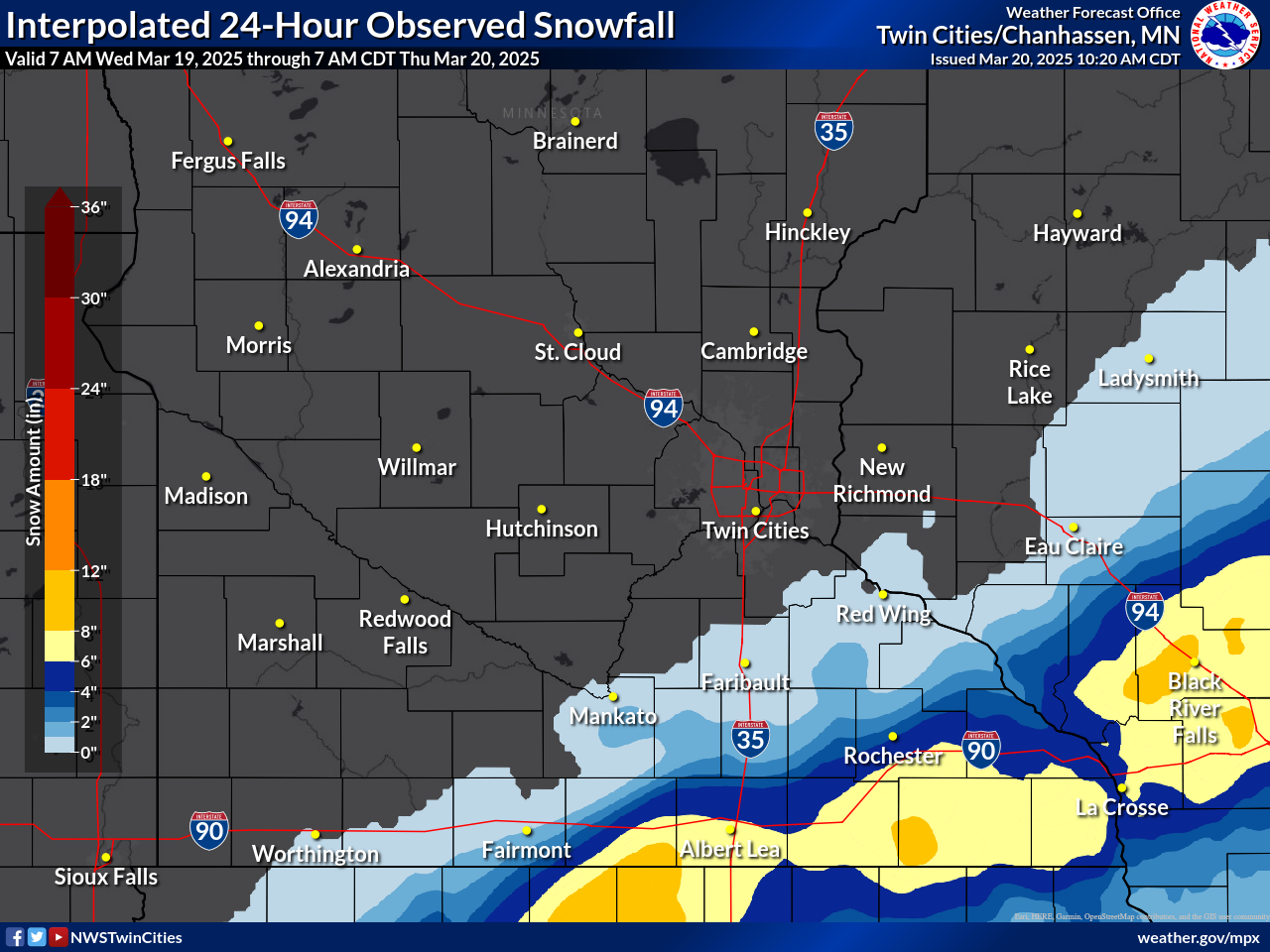
A narrow band of heavy snow feel across southern Minnesota, up through central Wisconsin. Total amounts generally ranged from 6 to 9 inches, with a few reports over a foot.
 |
 |
 |
| Satellite image from Wednesday morning showing areas of dust (tan) being wrapped northward across northeast Iowa and southwest Wisconsin by the strong cyclone. | MNDOT image from southern Steele County showing reduced visibility from heavy snow and wind. | MNDOT image from northern Steele County in stark contrast, showing only dry roads. |
Snowfall Reports
...SNOWFALL REPORTS FROM WINTER STORM ON WEDNESDAY MARCH 19, 2025...

Location                     Amount    Time/Date       Provider
2 NNE Bricelyn               9.5 in    0452 PM 03/19   Public
Bricelyn                     9.0 in    0936 PM 03/19   Broadcast Media
Albert Lea                   8.0 in    0936 PM 03/19   Broadcast Media
Blue Earth                   8.0 in    0305 PM 03/19   Cocorahs
Blue Earth 0.6 ESE           8.0 in    0700 AM 03/20   COCORAHS
1 SW Albert Lea              6.0 in    0400 PM 03/19   Cocorahs
Albert Lea 1WSW              6.0 in    0530 AM 03/20   COCORAHS
Wells                        6.0 in    0330 PM 03/19   Public
Wells 3.5 SE                 6.0 in    0700 AM 03/20   COCORAHS
Ellendale                    4.4 in    0330 PM 03/19   Cocorahs
Blue Earth 1S                4.0 in    0800 AM 03/20   COOP
1 SE Lemond                  3.0 in    0330 PM 03/19   Trained Spotter
Minnesota Lake 0.9 NNW       2.7 in    1100 AM 03/20   COCORAHS

Observations are collected from a variety of sources with varying
equipment and exposures. We thank all volunteer weather observers
for their dedication. Not all data listed are considered official.
Wind Reports
...HIGHEST WIND REPORTS FROM WEDNESDAY, MARCH 19, 2025...

Location                     Speed     Time/Date       Provider
Fairmont AP                  44 MPH    0911 AM 03/19   AWOS
Madison AP                   41 MPH    1235 PM 03/19   AWOS
Eden Prairie AP              41 MPH    1144 AM 03/19   ASOS
St. James AP                 41 MPH    1115 AM 03/19   AWOS
Canby AP                     39 MPH    0355 PM 03/19   AWOS
Mankato AP                   39 MPH    1130 AM 03/19   AWOS
Owatonna AP                  39 MPH    0848 AM 03/19   AWOS
Redwood Falls AP             39 MPH    0444 PM 03/19   ASOS
Ganoe Hill                   39 MPH    0407 PM 03/19   RAWS
Waseca AP                    38 MPH    1115 AM 03/19   AWOS
Albert Lea AP                38 MPH    1135 AM 03/19   AWOS
Crystal AP                   38 MPH    1147 AM 03/19   ASOS
St. Paul Dwtn AP             38 MPH    0527 PM 03/19   ASOS
Glencoe AP                   37 MPH    1235 PM 03/19   AWOS
Morris AP                    37 MPH    0415 PM 03/19   AWOS
Appleton AP                  36 MPH    0354 PM 03/19   AWOS
Alexandria MN ASOS           36 MPH    0109 PM 03/19   ASOS
Montevideo AP                36 MPH    1255 PM 03/19   AWOS
Sauk Centre AP               35 MPH    0455 PM 03/19   AWOS
Granite Falls AP             35 MPH    1035 AM 03/19   AWOS
Hutchinson AP                35 MPH    0855 AM 03/19   AWOS
Rice Lake AP                 35 MPH    0155 PM 03/19   AWOS
New Ulm AP                   35 MPH    0615 PM 03/19   AWOS

Observations are collected from a variety of sources with varying
equipment and exposures. We thank all volunteer weather observers
for their dedication. Not all data listed are considered official.
 |
Media use of NWS Web News Stories is encouraged! Please acknowledge the NWS as the source of any news information accessed from this site. |
|

