Overview
|
A historically strong mid-March low pressure system brought a round of low-end severe storms with damaging winds and small hail Friday evening across southern Minnesota. Storms weakened as they spread into central Minnesota and western Wisconsin Friday night, resulting in widespread, light rain.
As the system occluded, a deformation band set up over western Minnesota, leading to snowfall rates greater than an inch per hour and blizzard conditions Saturday morning. Overall snowfall accumulation was light, but the combination of strong winds gusting over 45 mph and heavy snowfall rates led to whiteout conditions across much of western Minnesota. |
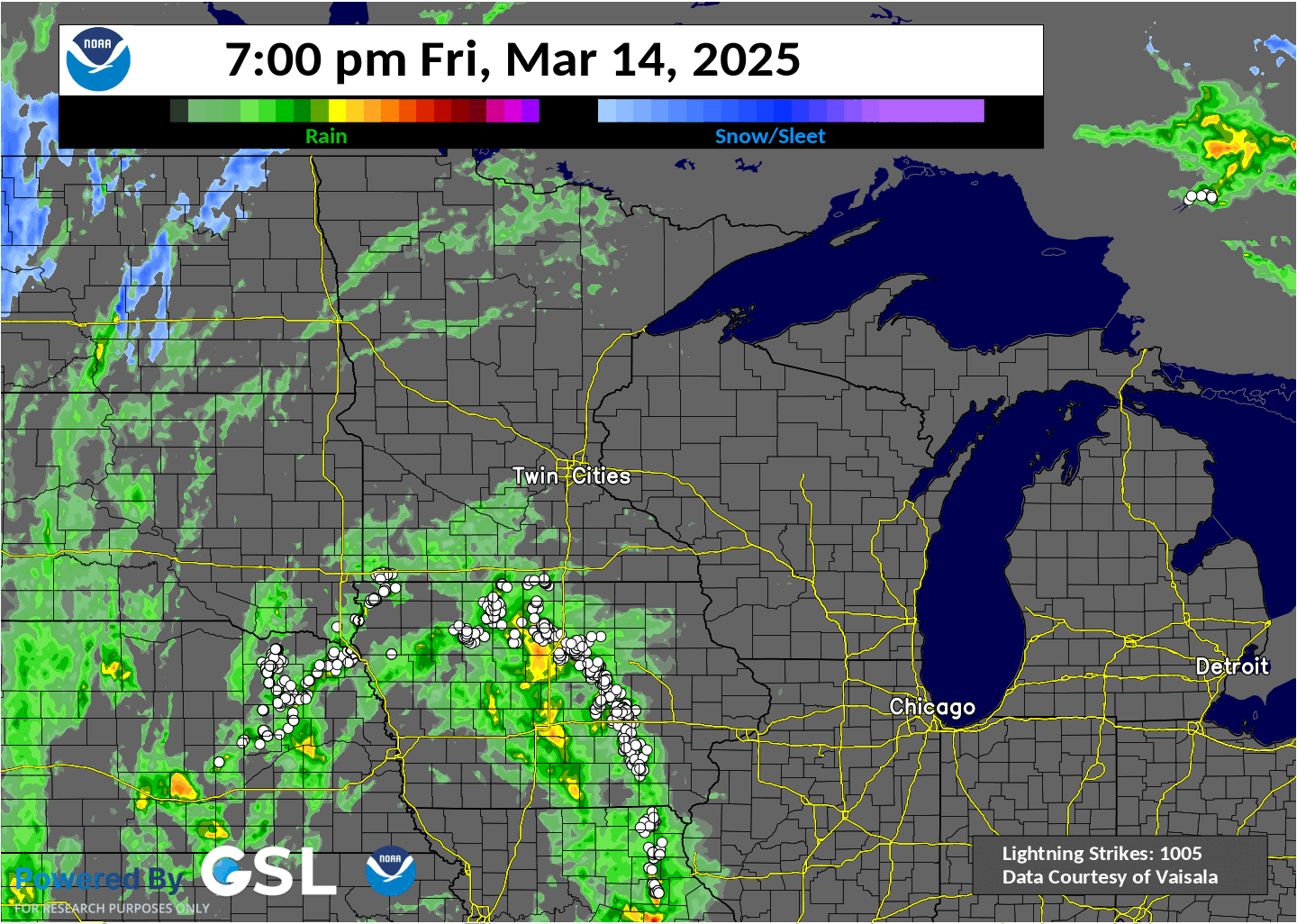 18 hour radar loop and precipitation type with lightning overlaid (white dots) from the March 14-15 storm system. A line of storms lifted up from the south on the evening of the 14th. Rain (green/yellow) changed over to snow (blue) across western Minnesota during the early morning hours of the 15th. |
 |
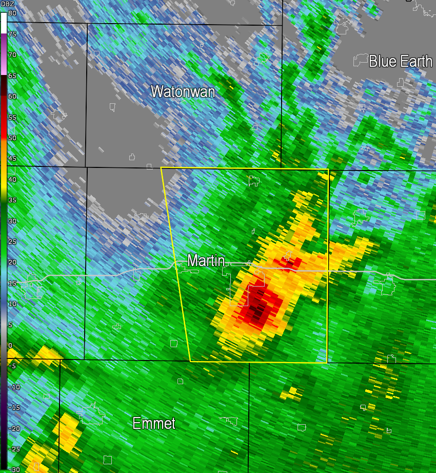 |
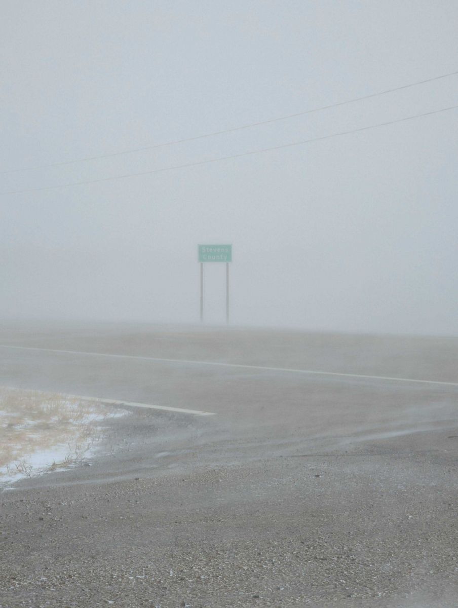
| The strong winds and heavy snowfall rates led to significant blowing and drifting snow, reducing visibilities and impacting travel conditions. Image from Stevens County courtesy of Nick Elms. | Radar reflectivity at 723 PM CDT showing a severe thunderstorms in Martin County. This storm produced a 59 mph wind gust at the Fairmont Airport. |
Summary
This particularly strong spring system brought a variety of precipitation types and hazards to the Upper Midwest, including severe thunderstorms, icing, and blizzard conditions.
 |
.png) |
.png) |
.png) |
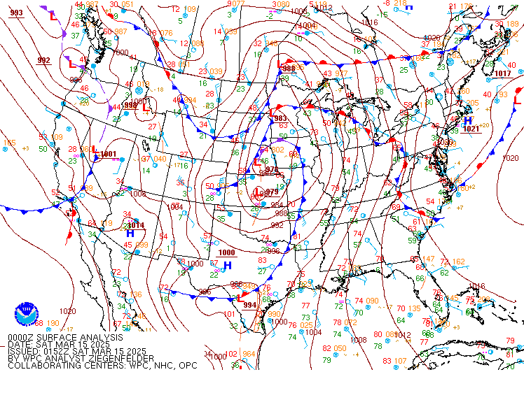
| A surface loop from March 14-15 shows the deepening low pressure that tracked across eastern Nebraska toward Lake Superior. A historic 2-Day severe weather outbreak resulted in widespread tornado, wind, and hail damage across the Mississippi River Valley (primarily south of Minnesota and western Wisconsin. | As rain transitioned to snow, a period of freezing rain resulted in light ice accretion for some areas in western Minnesota. This image was taken near Granite Falls by Emily Albin, showing ~1/8 inch of radial ice. | Whiteout conditions along a road near Cyrus in Pope County, Minnesota due to heavy falling snow and strong winds. Image courtesy of Melissa Peterson (@Melissanatphoto on X). | Map of observed snowfall from across the region. A band of 2 to 6 inches fell across western Minnesota. While snowfall amounts were light, sparse observations and difficulties from blowing and drifting snow may have artificially lowered snow amounts in some areas. |
Thunderstorm, Snow, and Wind Reports
...THUNDERSTORM WIND REPORTS FROM MARCH 14, 2025...

Location                     Speed     Time/Date       Provider
Fairmont AP                  58 MPH    0732 PM 03/14   AWOS
T.h.60 - Madelia - Mp 86     51 MPH    0815 PM 03/14   MESOWEST

...SNOWFALL REPORTS FROM MARCH 15, 2025...

Location                     Amount    Time/Date       Provider
2 SW Long Prairie            5.4 in    0225 PM 03/15   Trained Spotter
6 NE Kensington              4.7 in    0800 AM 03/16   COCORAHS
2 NW Chokio                  2.0 in    1030 AM 03/15   Emergency Mngr
Morris                       1.8 in    1030 AM 03/15   Emergency Mngr
Alexandria 4.0 NE            1.0 in    0800 AM 03/15   COCORAHS

...HIGHEST NON-THUNDERSTORM WIND REPORTS FROM MARCH 15, 2025...

Location                     Speed     Time/Date       Provider
Benson AP                    59 MPH    0935 AM 03/15   AWOS
St. James AP                 59 MPH    1035 AM 03/15   AWOS
Redwood Falls AP             58 MPH    0839 AM 03/15   ASOS
T.h.212 - Hector - Mp 84.4   56 MPH    1010 AM 03/15   MESOWEST
U.s.14 - Springfield - Mp 80 56 MPH    1020 AM 03/15   MESOWEST
Willmar AP                   55 MPH    0955 AM 03/15   AWOS
T.h.212 - Marietta - Mp 1    53 MPH    0755 AM 03/15   MESOWEST
Alexandria MN ASOS           53 MPH    0907 AM 03/15   ASOS
T.h.60 - Madelia - Mp 86     51 MPH    0945 AM 03/15   MESOWEST
T.h.19 - Morton - Mp 78      50 MPH    0810 AM 03/15   MESOWEST
Hanska                       49 MPH    1030 AM 03/15   CWOP
I-90 - Blue Earth - Mp 119   49 MPH    1040 AM 03/15   MESOWEST
T.h.19 - Winthrop - Mp 108   49 MPH    1040 AM 03/15   MESOWEST
T.h.19 - Winthrop - Mp 108   49 MPH    0250 PM 03/15   MESOWEST
Fairmont AP                  48 MPH    0936 AM 03/15   AWOS
U.s.169 - Henderson - Mp 86  48 MPH    1025 AM 03/15   MESOWEST
Crystal AP                   48 MPH    1216 PM 03/15   ASOS
Litchfield 3S                47 MPH    1011 AM 03/15   RAWS
New Ulm AP                   47 MPH    0315 PM 03/15   AWOS
Olivia AP                    46 MPH    1015 AM 03/15   AWOS
Hutchinson AP                46 MPH    1135 AM 03/15   AWOS
Minneapolis-St. Paul AP      46 MPH    1205 PM 03/15   ASOS
Fairmont                     45 MPH    0825 AM 03/15   DAVIS
Waseca AP                    45 MPH    1035 AM 03/15   AWOS

Observations are collected from a variety of sources with varying
equipment and exposures. We thank all volunteer weather observers
for their dedication. Not all data listed are considered official.
 |
Media use of NWS Web News Stories is encouraged! Please acknowledge the NWS as the source of any news information accessed from this site. |
|

