Overview
|
On Tuesday, March 04, to Wednesday, March 05, 2025 a powerful winter storm brought heavy snow and strong wind across the Upper Midwest. As is typical with these large spring systems, the March 04 started warmer with highs in the mid 40s. Clouds and precipitation increased throughout the day as the storm organized. In the evening, the rain changed to snow as cold air wrapped around the system. Northwest winds also strengthened, with widespread gusts of 40 to 50 mph causing significant blowing and drifting.
|
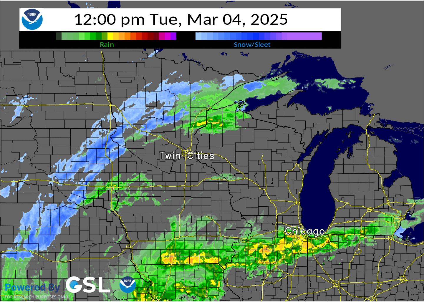 24 hour radar loop and precipitation type from the March 04-05 winter storm. Rain (green/yellow) changed over to snow (blue) Tuesday evening. The heaviest snow fell Tuesday night, and the storm excited the region Wednesday morning. |
 |
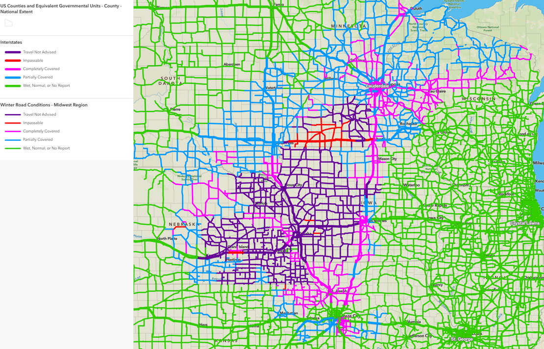 |
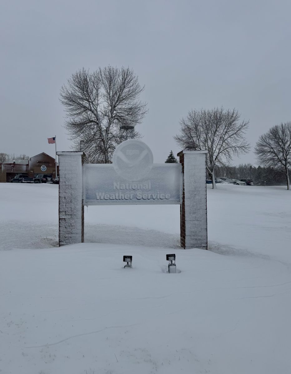
| The strong winds and wet nature of the snow as it transitioned over from rain caused it to slick to north face of trees, buildings, and in this case, our sign. | Road conditions as of 3 AM on March 05, 2025. The extensive travel impacts were seen from Missouri and Kansas, up through northern Minnesota and Wisconsin. |
Summary
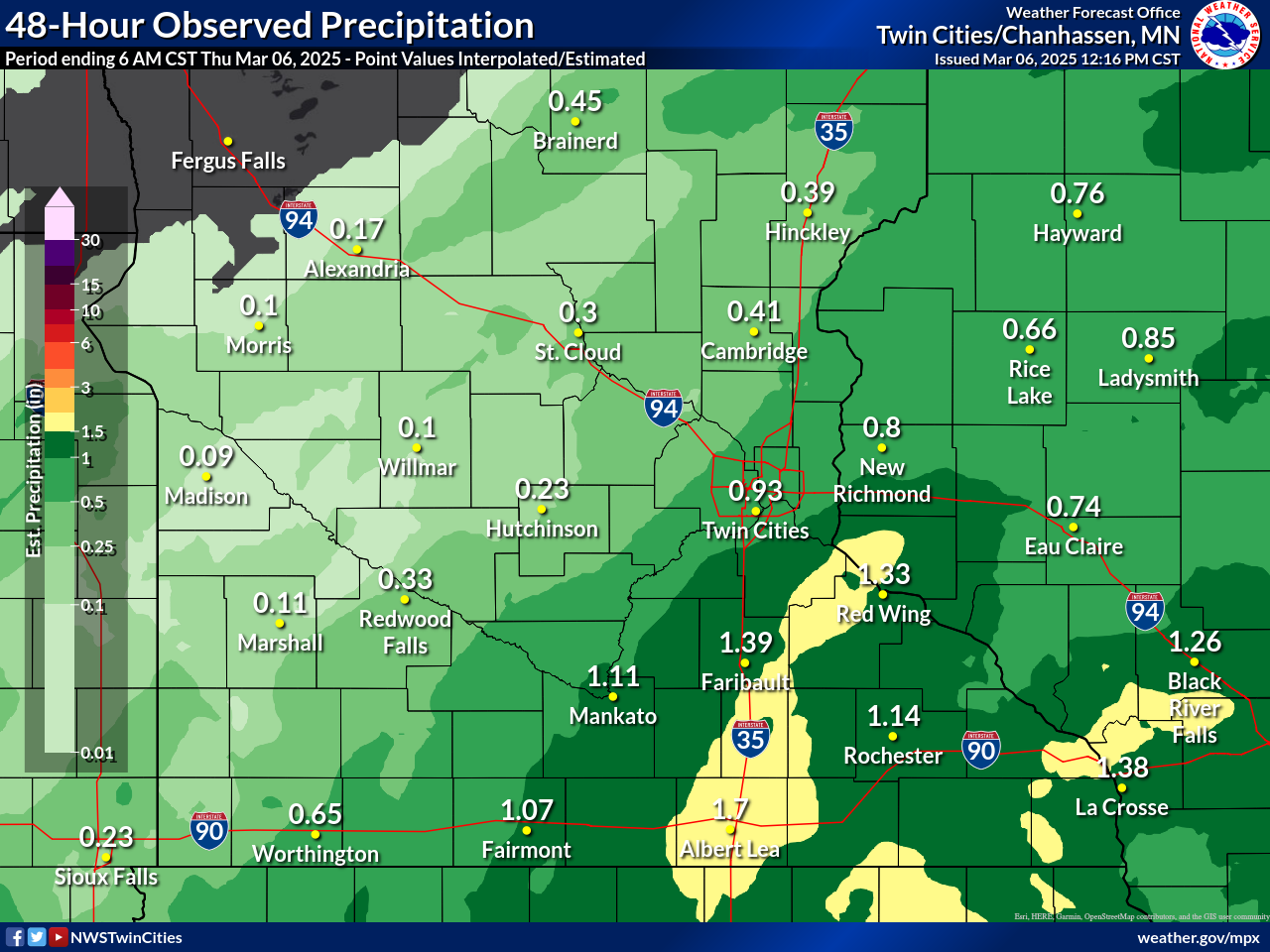
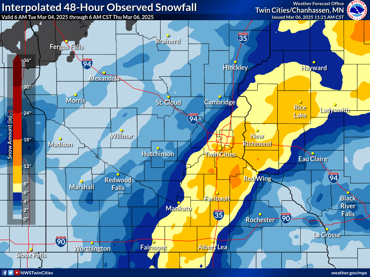
A narrow band of heavy snow feel across south central Minnesota, up through northwest Wisconsin. Total amounts generally ranged from 8 to 10 inches, with a few reports over a foot.
 |
 |
 |
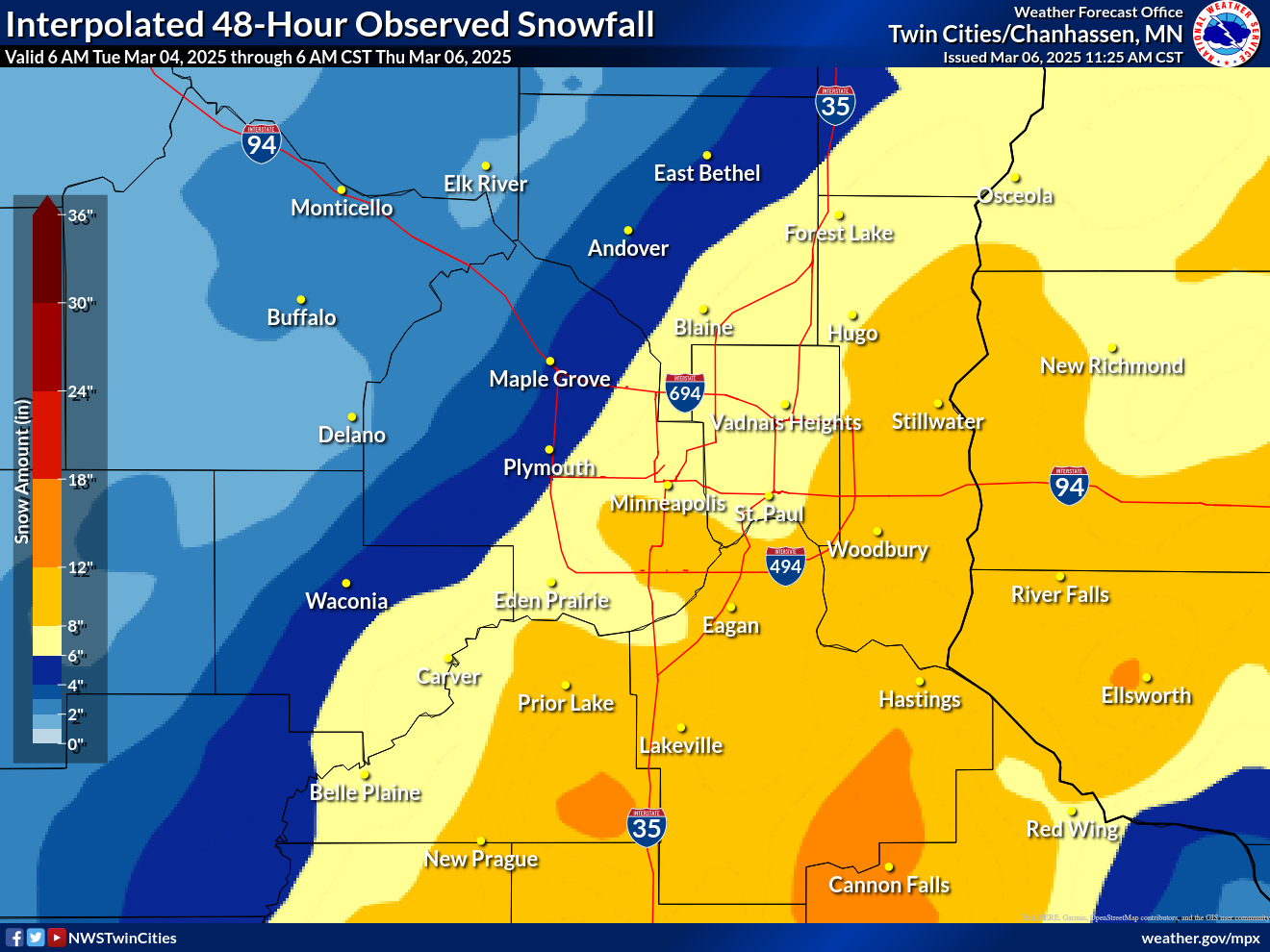 |
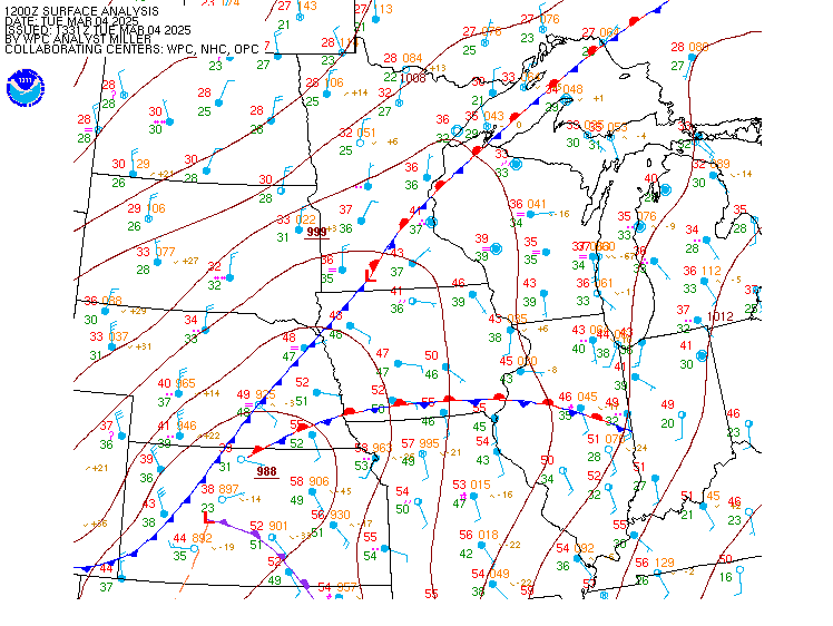
| The surface loop above from March 04-05 shows the deepening low pressure that tracked across southern Kansas toward Illinois | Precipitation amounts generally ranged from 1 to 1.5 inches, with a few reports near 2 inches under the heaviest band. | Map of observed snowfall from across the region. A narrow band of heavy snow fell from south central Minnesota through northwest Wisconsin. | Zoomed-in snowfall map for the Twin Cities area. There was a large contrast between the southeast metro that received up to a foot of snow, and the northwest metro that only had a few inches. |
Snowfall Reports
...SNOWFALL REPORTS...

Location                     Amount    Time/Date       Provider
2 NNE Dennison               13.0 in   0600 AM 03/05   Cocorahs
6 SW Credit River            12.0 in   0700 AM 03/05   Cocorahs
6 N Veseli                   12.0 in   0700 AM 03/05   COCORAHS
Nerstrand 4E                 11.9 in   0700 AM 03/05   COCORAHS
1 SSE Woodbury               11.8 in   0654 AM 03/05   Cocorahs
1 W Elko New Market          11.5 in   0700 AM 03/05   Cocorahs
Apple Valley 3SSE            11.1 in   0700 AM 03/05   COCORAHS
1 WSW Stillwater             11.0 in   0730 AM 03/05   Cocorahs
Owatonna 1.6 E               11.0 in   0800 AM 03/05   COCORAHS
Montgomery 1.8 NE            11.0 in   0700 AM 03/05   COCORAHS
River Falls 0.8 NNW          10.5 in   0700 AM 03/05   COCORAHS
Ellendale                    10.5 in   0552 AM 03/05   Cocorahs
1 S Prior Lake               10.5 in   0610 AM 03/05   Trained Spotter
Savage 1.0 NNE               10.0 in   0700 AM 03/05   COCORAHS
3 E Lakeville                10.0 in   0700 AM 03/05   Cocorahs
Farmington 1.7 NNW           10.0 in   0700 AM 03/05   COCORAHS
Inver Grove Heights 1.0 S    10.0 in   0730 AM 03/05   COCORAHS
Northfield 1.8 NNE           9.8 in    0700 AM 03/05   COCORAHS
1 E Hudson                   9.7 in    0800 AM 03/05   COCORAHS
Spring Valley 5.2 SW         9.2 in    0730 AM 03/05   COCORAHS
North St. Paul 1WNW          9.2 in    0700 AM 03/05   COCORAHS
Somerset 1.6 N               9.0 in    0700 AM 03/05   COCORAHS
White Bear Lake 2.6 W        8.5 in    0800 AM 03/05   COCORAHS
Bloomington                  8.5 in    0730 AM 03/05   Trained Spotter
Fridley 1.8 SE               8.4 in    0800 AM 03/05   COCORAHS
Chetek 2SE                   8.0 in    0700 AM 03/05   COCORAHS
Albert Lea 1WSW              8.0 in    0700 AM 03/05   COCORAHS
Osceola                      7.5 in    0755 AM 03/05   Public
1 NNE Kenyon                 7.5 in    0200 AM 03/05   Public
1 NNE Mankato                7.5 in    0700 AM 03/05   Cocorahs
1 SSW Jordan                 7.3 in    0530 AM 03/05   CO-OP Observer
Clarks Grove 0.8 WNW         7.0 in    0800 AM 03/05   COCORAHS

Observations are collected from a variety of sources with varying
equipment and exposures. We thank all volunteer weather observers
for their dedication. Not all data listed are considered official.
Precipitation Reports
...PRECIPITATION REPORTS FROM PAST 24 HOURS...

Precipitation reports of 1 inch or greater are listed below.

Location                     Amount    Time/Date       Provider
Northfield 0.4 SSW           2.04 in   0700 AM 03/05   COCORAHS
Nerstrand 4E                 1.94 in   0700 AM 03/05   COCORAHS
Dennison 2.0 NNE             1.86 in   0600 AM 03/05   COCORAHS
Ellendale 0.3 SW             1.84 in   0700 AM 03/05   COCORAHS
Hager City 1.8 WNW           1.61 in   0800 AM 03/05   COCORAHS
Northfield 1.2 NNW           1.50 in   0700 AM 03/05   COCORAHS
Red Wing                     1.45 in   1100 AM 03/05   CWOP
Owatonna 1.0 ENE             1.44 in   0700 AM 03/05   COCORAHS
1 E Hudson                   1.43 in   0800 AM 03/05   COCORAHS
Mankato 2.8 WSW              1.40 in   0700 AM 03/05   COCORAHS
Owatonna 1.5 N               1.40 in   0700 AM 03/05   COCORAHS
Apple Valley 3SSE            1.39 in   0700 AM 03/05   COCORAHS
Pine Island 3.9 ENE          1.35 in   0700 AM 03/05   COCORAHS
Northfield 7.8 NNE           1.34 in   0700 AM 03/05   COCORAHS
Mankato 0.6 N                1.33 in   0700 AM 03/05   COCORAHS
Stockholm 2NE                1.32 in   0800 AM 03/05   COCORAHS
Garden City 2.7 WSW          1.27 in   0715 AM 03/05   COCORAHS
Spring Valley 5.2 SW         1.26 in   0730 AM 03/05   COCORAHS
Red Wing                     1.25 in   0650 AM 03/05   COOP
Menomonie 3.3 SE             1.22 in   0700 AM 03/05   COCORAHS
Dennison 0.4 SSE             1.21 in   0800 AM 03/05   COCORAHS
Faribault                    1.20 in   0700 AM 03/05   COOP
Durand 1.5 SW                1.20 in   0700 AM 03/05   COCORAHS
Montgomery 3ENE              1.19 in   0600 AM 03/05   COCORAHS
Northfield 2NE               1.18 in   0730 AM 03/05   COCORAHS
Hastings 1.6 NW              1.17 in   0530 AM 03/05   COCORAHS
Inver Grove Heights 1.0 S    1.17 in   0730 AM 03/05   COCORAHS
St Paul Park 0.6 NNE         1.17 in   0700 AM 03/05   COCORAHS
Prior Lake 1WSW              1.15 in   0700 AM 03/05   COCORAHS
Woodbury 1.7 N               1.13 in   0700 AM 03/05   COCORAHS
North St. Paul 1WNW          1.11 in   0700 AM 03/05   COCORAHS
River Falls 3.3 S            1.11 in   0639 AM 03/05   COCORAHS
River Falls 1SW              1.11 in   0700 AM 03/05   COCORAHS
Northfield 1.8 NNE           1.10 in   0700 AM 03/05   COCORAHS
Burnsville 2.3 E             1.10 in   0700 AM 03/05   COCORAHS
Saint Paul 4.6               1.10 in   0800 AM 03/05   COCORAHS
Hastings 0.7 S               1.09 in   0600 AM 03/05   COCORAHS
Bayport 0.2 ESE              1.09 in   0700 AM 03/05   COCORAHS
Baldwin                      1.08 in   0730 AM 03/05   COOP
St. Louis Park 2ESE          1.07 in   0700 AM 03/05   COCORAHS
Oakdale 0.4 S                1.05 in   0700 AM 03/05   COCORAHS
Inver Grove Heights 1.4 ESE  1.04 in   0900 AM 03/05   COCORAHS
White Bear Lake 2.3 S        1.04 in   0700 AM 03/05   COCORAHS
Minneapolis 2.5 SE           1.03 in   0700 AM 03/05   COCORAHS
Stillwater 0.8 SW            1.03 in   0730 AM 03/05   COCORAHS
Hopkins 0.3 WNW              1.02 in   0700 AM 03/05   COCORAHS
Maplewood 4.6 SSE            1.02 in   0715 AM 03/05   COCORAHS
Shoreview 2.5 N              1.02 in   0700 AM 03/05   COCORAHS
Woodbury 0.3 NNW             1.02 in   0654 AM 03/05   COCORAHS
Mendota Hgts 2WNW            1.01 in   0700 AM 03/05   COCORAHS
Woodbury 3.3 SW              1.01 in   0700 AM 03/05   COCORAHS
Oak Park Heights             1.01 in   0600 AM 03/05   COCORAHS

Observations are collected from a variety of sources with varying
equipment and exposures. We thank all volunteer weather observers
for their dedication. Not all data listed are considered official.
Wind Reports
...HIGHEST WIND GUSTS FROM PAST 24 HOURS...

Location                     Speed     Time/Date       Provider
Fairmont AP                  53 MPH    0114 AM 03/05   AWOS
Madison AP                   48 MPH    1015 PM 03/04   AWOS
Redwood Falls AP             47 MPH    0124 AM 03/05   ASOS
Eden Prairie AP              46 MPH    0401 AM 03/05   ASOS
Mankato AP                   45 MPH    1231 AM 03/05   AWOS
Appleton AP                  44 MPH    0433 AM 03/05   AWOS
Alexandria MN ASOS           44 MPH    0433 AM 03/05   ASOS
Minneapolis-St. Paul AP      44 MPH    0446 AM 03/05   ASOS
Montevideo AP                44 MPH    1215 AM 03/05   AWOS
Morris AP                    43 MPH    1055 PM 03/04   AWOS
St. Cloud AP                 43 MPH    0125 AM 03/05   ASOS
St. Paul Dwtn AP             43 MPH    0732 AM 03/05   ASOS
New Ulm AP                   43 MPH    0715 AM 03/05   AWOS
Eau Claire AP                41 MPH    0533 AM 03/05   ASOS
Hutchinson AP                41 MPH    1215 AM 03/05   AWOS
Benson AP                    40 MPH    0935 AM 03/05   AWOS
Canby AP                     40 MPH    0855 AM 03/05   AWOS
Crystal AP                   40 MPH    0858 AM 03/05   ASOS
Olivia AP                    40 MPH    0315 AM 03/05   AWOS
Waseca AP                    39 MPH    0835 AM 03/05   AWOS
Willmar AP                   39 MPH    0415 AM 03/05   AWOS
Sauk Centre AP               39 MPH    0455 AM 03/05   AWOS
Granite Falls AP             39 MPH    0355 AM 03/05   AWOS
Glencoe AP                   39 MPH    1215 AM 03/05   AWOS
Litchfield AP                39 MPH    0915 AM 03/05   AWOS
Buffalo AP                   38 MPH    0955 AM 03/05   AWOS
Maple Lake AP                38 MPH    0855 AM 03/05   AWOS
Owatonna AP                  38 MPH    0818 PM 03/04   AWOS
Albert Lea AP                37 MPH    0835 AM 03/05   AWOS
Albert Lea AP                36 MPH    0515 AM 03/05   AWOS
Paynesville AP               36 MPH    0135 AM 03/05   AWOS
Tony AP                      36 MPH    0955 AM 03/05   AWOS
New Richmond AP              36 MPH    0715 AM 03/05   AWOS
Rush City AP                 36 MPH    0815 AM 03/05   ASOS
Rice Lake AP                 36 MPH    0455 AM 03/05   AWOS
Cumberland AP                36 MPH    0935 AM 03/05   AWOS
Long Prairie AP              35 MPH    0635 AM 03/05   AWOS
Glenwood AP                  35 MPH    0455 AM 03/05   AWOS
Camp Ripley                  35 MPH    0755 AM 03/05   AWOS
Stanton AP                   35 MPH    0615 AM 03/05   AWOS
Chetek AP                    35 MPH    0715 AM 03/05   AWOS

Observations are collected from a variety of sources with varying
equipment and exposures. We thank all volunteer weather observers
for their dedication. Not all data listed are considered official.
 |
Media use of NWS Web News Stories is encouraged! Please acknowledge the NWS as the source of any news information accessed from this site. |
|

