Grade Summary
This was a tough system to forecast. A potent area of low pressure occluded over the Missouri Valley and then slowly dropped southeast away from the area. Rain, snow, and sleet showers, and even a few thunderstorms pushed across the area during the evening of March 4th and during the early morning hours of March 5th. As the event closed in, it became more apparent the system was going to occlude a little further west than previously anticipated, which resulted in a delay in the heavy snow across eastern Minnesota into western Wisconsin. This also meant temperatures were colder further south and west, allowing the expected rain across southern and western Minnesota to turn over to snow many hours sooner than predicted. Winter Storm Warnings were initially issued for central and eastern Minnesota and portions of western Wisconsin, but were expanded to include all of central and southern Minnesota by late Monday morning. Snow rates reached 2 inches per hour in the southern Twin Cities metro in the mid to late afternoon shortly after the snow began and just before the afternoon commute. Luckily, the strongest winds occurred before the heavy snowfall began. As a result, blizzard conditions (35 mph winds and 1/4 mile visibility for 3 hours) were not observed. The Minnesota State Patrol reported 260 accidents and 36 injuries, 434 vehicle spinouts, and 17 jackknifed semis from midnight to 8:45 pm on March 5th.
Local conditions and perceptions may vary from the objective grade calculated below. Step through the other tabs to see a breakdown of the scoring.
|
81% |
Graded Element | Possible Points | Actual Points |
| 6 inch contour error | N/A | N/A | |
| Magnitude of snow error | 8 | 8 | |
| Onset timing error | 4 | 0 | |
| Peak wind gust error | 4 | 4 | |
| Probability of Detection/False Alarm Ratio | 8 | 6 | |
| Warning lead time | 8 | 8 | |
| Impact messaging | 4 | 3 | |
| Total | 36 | 29 | |
| Grade | 81% |

6 inch contour error
The 6 inch contour error could not be calculated for this event due to the irregular nature of the observed 6+ inch area and difficulty in making an objective measurement.
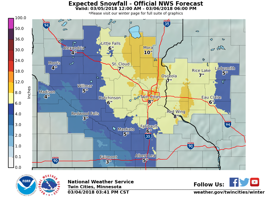
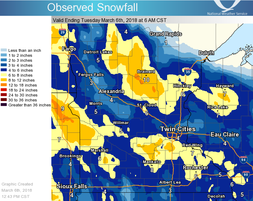
There were two areas of heavy snow totals. One occurred across central Minnesota where snow began early morning on March 5th and continued into the 6th. The heaviest totals were measured there with a couple reports over 10 inches. Another narrow band of heavy snow fell from west central Minnesota to southeast Minnesota, including the southern Twin Cities metro. 6 to 9 inches were reported there. In between these two bands, there were several dry hours on March 5th, and the heaviest snow stalled just to the south. In addition, some freezing rain and sleet mixed in with the light snow in those areas, which cut down on storm totals but still allowed the warning to verify.
 |
 |
| Official snowfall forecast at initial warning issuance |
Observed Snowfall (automatically generated graphic, with some interpolation and smoothing) |
| Error | Points |
| <=15 miles | 8 |
| 16-20 miles | 7 |
| 21-25 miles | 6 |
| 26-30 miles | 5 |
| 31-35 miles | 4 |
| 36-40 miles | 3 |
| 41-45 miles | 2 |
| 46-50 miles | 1 |
| 51+ miles | 0 |
| Actual: N/A | N/A |
Magnitude of snow error
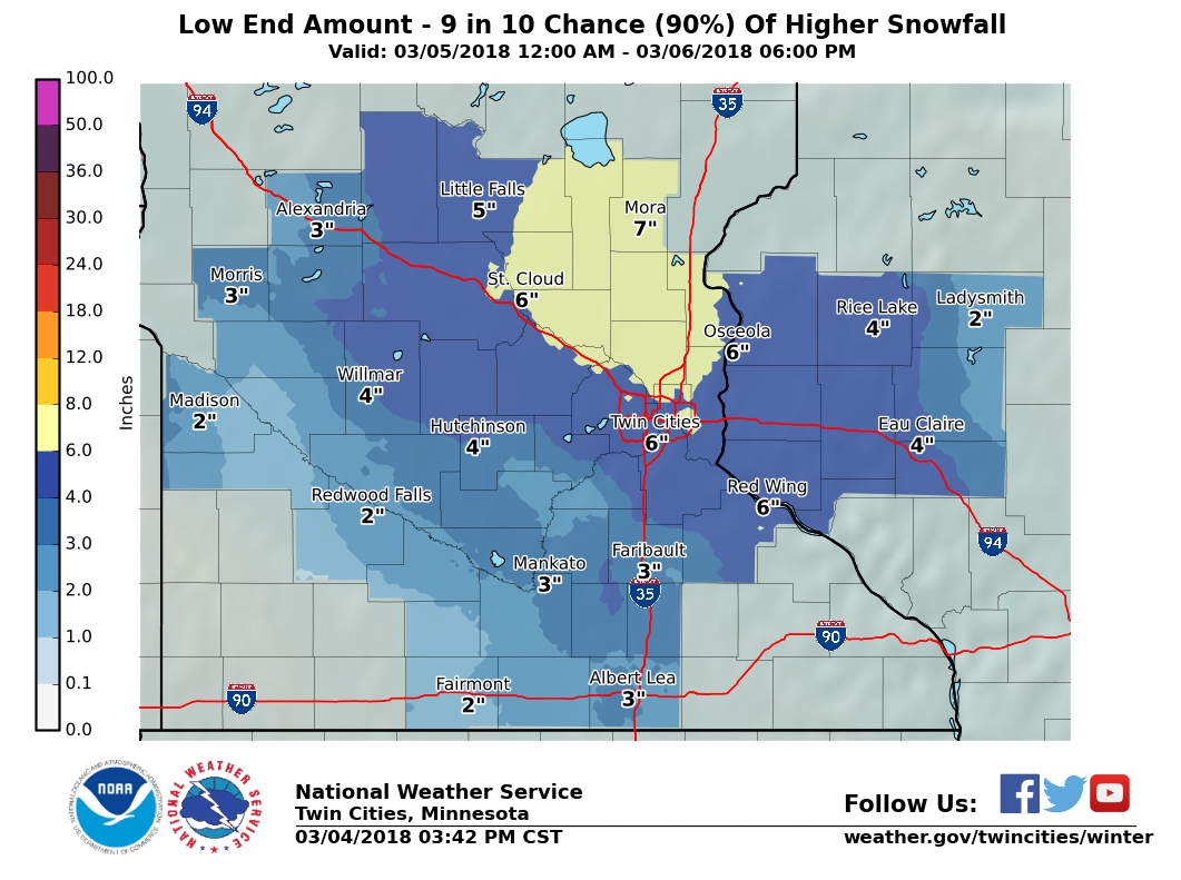
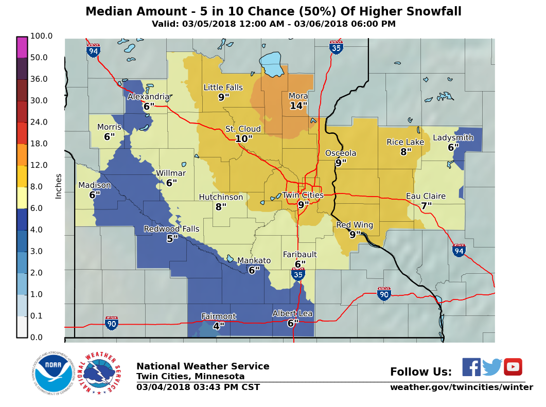
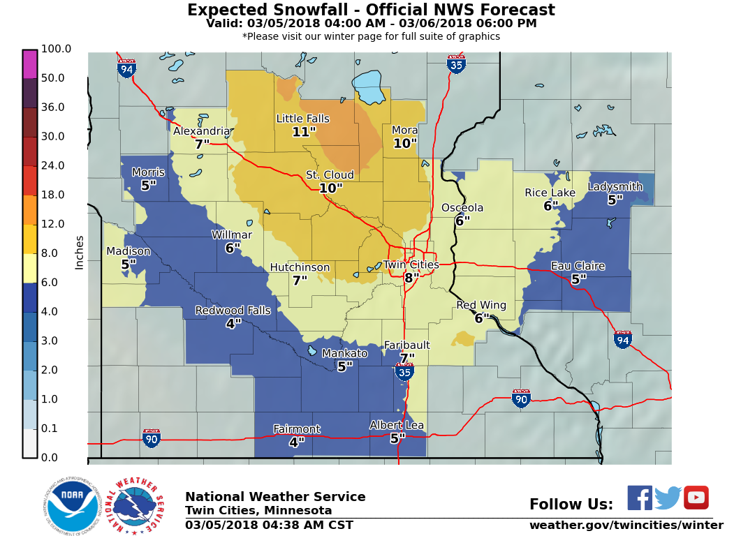
The highest amount of snow forecast was around 10 inches near Kanabec, Mille Lacs, and Isanti counties in Minnesota. The actual highest total was 10.6 inches in Browerville, MN.
Forecast with initial warning issuance
Sunday afternoon, March 4, 2018:
 |
 |
 |
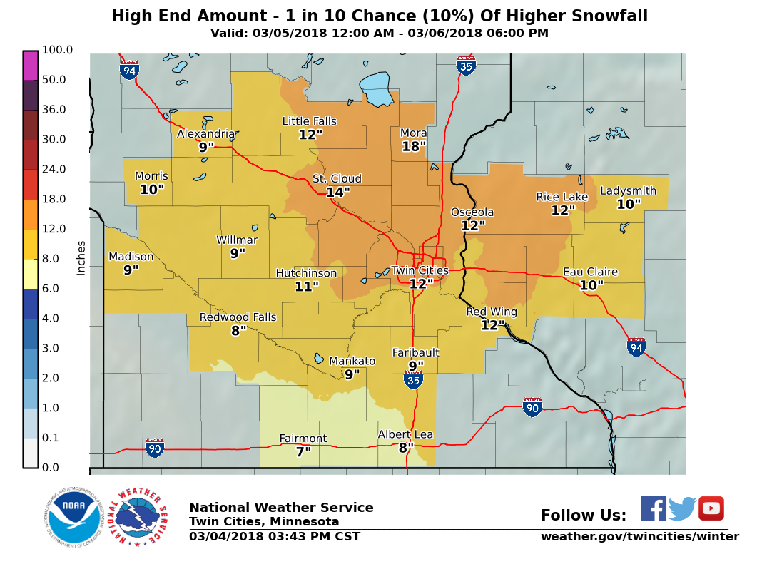 |
| Official snowfall forecast | Low end amount (90% chance for more snow than this) | Median amount (equal chances for more or less than this) | High end amount (10% chance for more snow than this) |
| Error | Points |
| <=2" | 8 |
| 2.1-3.5" | 6 |
| 3.6-5.0" | 4 |
| 5.1-6.5" | 2 |
| 6.6+" | 0 |
| Actual: 0.6" | 8 |
Subsequent Forecasts
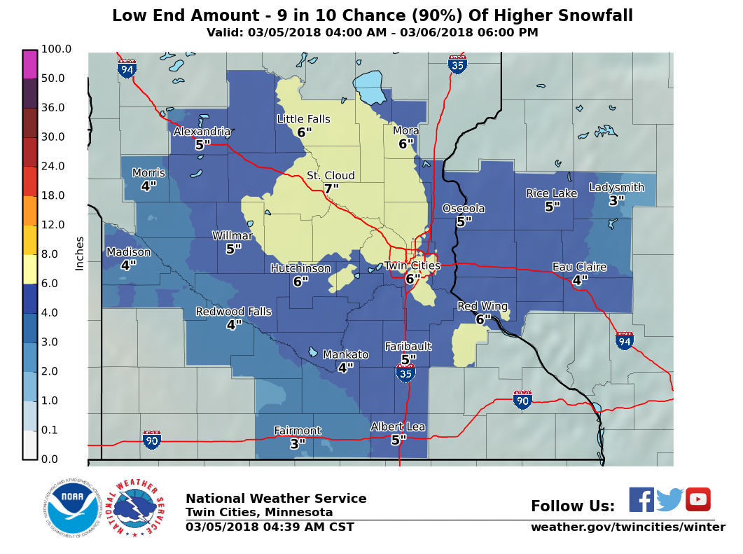
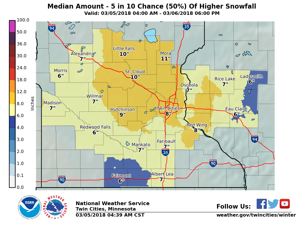
Monday morning, March 5, 2018:
 |
 |
 |
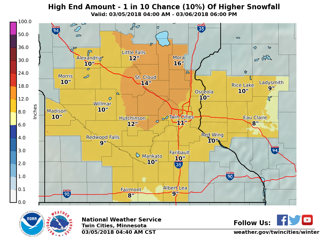 |
| Official snowfall forecast | Low end amount (90% chance for more snow than this) | Median amount (equal chances for more or less than this) | High end amount (10% chance for more snow than this) |
Snowfall reports by county:
Location                     Amount    Time/Date       Provider

...Minnesota...

...Anoka County...
East Bethel 4ENE             6.8 in    0400 AM 03/06   COCORAHS
Andover 1n                   4.5 in    0600 AM 03/06   COOP

...Benton County...
5 SW Foley                   6.3 in    0808 AM 03/06   Trained Spotter
Rice                         3.8 in    0700 AM 03/06   COOP
1 NE Rice                    3.3 in    0700 AM 03/06
Rice                         3.3 in    0700 AM 03/06   COOP

...Blue Earth County...
Mankato 4E                   7.2 in    0700 AM 03/06   UCOOP

...Brown County...
Sveadahl 5NNW                6.2 in    0655 AM 03/06   COCORAHS

...Carver County...
Victoria 1WSW                8.5 in    0700 AM 03/06   COCORAHS
Waconia                      7.3 in    0600 AM 03/06   UCOOP
2 SSW Victoria               7.0 in    0906 AM 03/06   COCORAHS
Chaska                       6.5 in    0624 AM 03/06   COCORAHS
Chanhassen (NWS)             6.1 in    0600 AM 03/06   COOP
Watertown                    5.5 in    0400 AM 03/06   COCORAHS

...Chippewa County...
Montevideo                   8.1 in    0700 AM 03/06   COCORAHS

...Chisago County...
North Branch 1NNW            4.5 in    0600 AM 03/06   COCORAHS
Stacy 1W                     4.3 in    0700 AM 03/06   COCORAHS

...Dakota County...
Rosemount (AG Exp Frm)       8.0 in    0800 AM 03/06   COOP
Lakeville                    7.1 in    0637 AM 03/06   Trained Spotter
Rosemount 3W                 7.0 in    0709 AM 03/06   COCORAHS
Burnsville                   6.8 in    0930 AM 03/06   Broadcast Media
Northfield 2NE               6.4 in    0550 AM 03/06   COCORAHS
2 SW Rosemount               5.5 in    0700 AM 03/06
Apple Valley 3ESE            5.5 in    0700 AM 03/06   COCORAHS
West St. Paul                5.0 in    0822 AM 03/06   Trained Spotter

...Douglas County...
1 S Alexandria               3.0 in    0845 AM 03/06
Nelson 2WSW                  1.6 in    0700 AM 03/06   COCORAHS
3 SW Nelson                  1.5 in    0700 AM 03/06
Nelson 2WSW                  1.5 in    0700 AM 03/06   COCORAHS

...Faribault County...
Winnebago                    6.0 in    0645 AM 03/06   COOP
Blue Earth                   4.0 in    0700 AM 03/06   COCORAHS
Wells                        4.0 in    0800 AM 03/06   COOP

...Freeborn County...
Albert Lea 3SE               3.5 in    0800 AM 03/06   COOP

...Goodhue County...
Zumbrota                     7.0 in    0700 AM 03/06   COOP
Red Wing 4W                  6.5 in    0700 AM 03/06   COCORAHS
Nerstrand 4E                 6.4 in    0700 AM 03/06   COCORAHS
Zumbrota                     6.0 in    0520 AM 03/06   COCORAHS
Red Wing (L/D 3)             6.0 in    0600 AM 03/06   COOP
Vasa 5NNE                    5.3 in    0700 AM 03/06   COCORAHS

...Hennepin County...
Chanhassen 2SE               7.1 in    0800 AM 03/06   COCORAHS
Bloomington 1 ESE            6.2 in    0700 AM 03/06   COCORAHS
2 N Golden Valley            6.0 in    0836 AM 03/06   Public
Bloomington 1 ESE            5.9 in    0700 AM 03/06   COCORAHS
Edina 1SE                    5.5 in    0600 AM 03/06   COCORAHS
Edina 1SW                    5.4 in    0858 AM 03/06   COCORAHS
Edina 2 ENE                  5.1 in    0700 AM 03/06   COCORAHS
Long Lake                    5.0 in    0700 AM 03/06   COCORAHS
New Hope 2S                  4.9 in    0445 AM 03/06   COCORAHS
Minneapolis-St. Paul AP-MSP  4.4 in    0553 AM 03/06   ASOS
1 ENE Maple Plain            4.3 in    0730 AM 03/06   Trained Spotter
Robbinsdale                  4.2 in    0700 AM 03/06   COCORAHS
Golden Valley                4.0 in    0700 AM 03/06   COCORAHS
Minneapolis 2NE              4.0 in    0700 AM 03/06   COCORAHS
2 NE Corcoran                3.7 in    0748 AM 03/06   COCORAHS
2 SW Fridley                 3.3 in    0700 AM 03/06
Brooklyn Center 1E           3.3 in    0700 AM 03/06   COCORAHS

...Isanti County...
Cambridge 3N                 6.3 in    0700 AM 03/06   COCORAHS
Braham 1ENE                  6.3 in    0718 AM 03/06   COCORAHS

...Kandiyohi County...
Willmar 5N                   3.6 in    0600 AM 03/06   COOP

...Lac qui Parle County...
Montevideo 1SW               6.5 in    0700 AM 03/06   COOP

...Le Sueur County...
Waterville                   6.2 in    0653 AM 03/06   COCORAHS

...Martin County...
Fairmont                     3.5 in    0700 AM 03/06   COCORAHS

...McLeod County...
Glencoe                      5.5 in    0800 AM 03/06   COCORAHS
Silver Lake 1NNW             4.1 in    0700 AM 03/06   COCORAHS

...Meeker County...
Dassel                       5.3 in    0700 AM 03/06   COCORAHS

...Mille Lacs County...
Onamia (RS)                  7.9 in    0900 AM 03/06   COOP
2 NW Foreston                7.9 in    0930 AM 03/06   Trained Spotter
Onamia 4WNW                  7.8 in    0800 AM 03/06   COCORAHS

...Morrison County...
Little Falls                 10.5 in   0700 AM 03/06   COCORAHS
Camp Ripley 4E               7.8 in    0700 AM 03/06   COCORAHS

...Nicollet County...
1 WSW North Mankato          6.0 in    0815 AM 03/06   Broadcast Media
New Ulm 3SE                  3.9 in    0555 AM 03/06   COOP

...Ramsey County...
Maplewood                    4.4 in    0700 AM 03/06   UCOOP
St. Paul (UMN-AG Exp Frm)    3.8 in    0800 AM 03/06   COOP
North St. Paul 1NNW          3.5 in    0700 AM 03/06   COCORAHS
1 NW North St. Paul          3.1 in    0700 AM 03/06
North St. Paul 1WNW          3.1 in    0700 AM 03/06   COCORAHS
2 SSE New Brighton           3.0 in    0600 AM 03/06
Roseville 2WNW               3.0 in    0600 AM 03/06   COCORAHS

...Redwood County...
Vesta                        6.0 in    0900 AM 03/06   COOP
Redwood Falls                4.2 in    0530 AM 03/06   COOP

...Renville County...
Bird Island 7SSE             6.4 in    0700 AM 03/06   COCORAHS
Lake Lillian 5SE             5.0 in    0700 AM 03/06   COCORAHS

...Rice County...
Montgomery 3ENE              8.0 in    0530 AM 03/06   COCORAHS
Northfield                   7.5 in    0600 AM 03/06   Public
Faribault                    6.0 in    0700 AM 03/06   COOP

...Scott County...
Prior Lake 1WSW              8.6 in    0700 AM 03/06   COCORAHS
2 N Prior Lake               7.6 in    0600 AM 03/06   Trained Spotter
2 WNW Savage                 7.4 in    0604 AM 03/06   Dept of Highways
Jordan 1SW                   5.7 in    0530 AM 03/06   COOP

...Sherburne County...
St. Cloud Airport            6.5 in    1220 AM 03/06   Official NWS Obs
Elk River                    5.4 in    0715 AM 03/06   COOP
Orrock 2SE                   4.0 in    0700 AM 03/06   COCORAHS

...Stearns County...
5 S St. Cloud                7.0 in    0800 AM 03/06   Public
Sartell 1SSE                 6.8 in    0700 AM 03/06   COCORAHS
St. Cloud (SCSU)             6.3 in    0500 AM 03/06   UCOOP
Kimball 3N                   6.0 in    0600 AM 03/06   COOP

...Steele County...
Owatonna                     4.8 in    0630 AM 03/06   COCORAHS
Ellendale                    4.2 in    0700 AM 03/06   COCORAHS

...Stevens County...
Donnelly 2WNW                4.3 in    0700 AM 03/06   COCORAHS
3 NW Donnelly                3.1 in    0700 AM 03/06
Donnelly 2WNW                3.1 in    0700 AM 03/06   COCORAHS
Morris (AG Exp Frm)          3.0 in    0800 AM 03/06   COOP

...Todd County...
Browerville                  10.6 in   0700 AM 03/06   COCORAHS
Long Prairie                 8.1 in    0600 AM 03/06   COOP

...Waseca County...
1 NE Waseca                  2.5 in    0700 AM 03/06
Waseca 1NNE                  2.5 in    0700 AM 03/06   COCORAHS

...Washington County...
St. Paul Park                5.1 in    0700 AM 03/06   COCORAHS
2 SSW Stillwater             2.5 in    0600 AM 03/06
Stillwater 2 SW              2.5 in    0600 AM 03/06   COCORAHS
1 NNE Stillwater             2.0 in    0636 AM 03/06
Stillwater 1NE               2.0 in    0636 AM 03/06   COCORAHS
4 N Birchwood Village        2.0 in    0800 AM 03/06
3 N Birchwood Village        2.0 in    0800 AM 03/06   COCORAHS
Afton                        2.0 in    0900 AM 03/06
Afton 1E                     2.0 in    0900 AM 03/06   COCORAHS

...Watonwan County...
St James Filt Plant          5.5 in    0800 AM 03/06   COOP

...Wright County...
Rockford                     3.2 in    0700 AM 03/06   COOP
Monticello 4WNW              2.0 in    0800 AM 03/06   COCORAHS

...Wisconsin...

...Barron County...
Cumberland                   7.5 in    0835 AM 03/06   Trained Spotter
Chetek 2SE                   4.5 in    0700 AM 03/06   COCORAHS

...Chippewa County...
Eau Claire AP                4.3 in    0556 AM 03/06   ASOS
Bloomer                      4.0 in    0800 AM 03/06   COOP
Chippewa Falls               4.0 in    0800 AM 03/06   COOP

...Dunn County...
Boyceville 3NNE              4.0 in    0700 AM 03/06   COCORAHS
Cedar Falls (Hydro)          3.0 in    0600 AM 03/06   COOP
Elk Mound                    3.0 in    0730 AM 03/06

...Eau Claire County...
Eau Claire                   4.1 in    0600 AM 03/06   Official NWS Obs
2 WNW Eau Claire             3.0 in    0500 AM 03/06
Eau Claire 1WNW              3.0 in    0500 AM 03/06   COCORAHS

...Pepin County...
Durand                       4.0 in    0800 AM 03/06   COOP

...Pierce County...
Ellsworth 1S                 6.0 in    0700 AM 03/06   COCORAHS
River Falls 1S               3.7 in    0700 AM 03/06   COCORAHS

...Polk County...
Balsam Lake 4SE              4.2 in    0700 AM 03/06   COCORAHS
3 E Nye                      2.5 in    0800 AM 03/06
Nye 2E                       2.5 in    0800 AM 03/06   COCORAHS

...Rusk County...
Ladysmith 2WNW               5.8 in    0700 AM 03/06   COCORAHS
Bruce 1E                     4.1 in    0700 AM 03/06   COCORAHS

...St. Croix County...
Baldwin                      3.5 in    0700 AM 03/06   COOP
1 SSW Roberts                3.2 in    0700 AM 03/06
Roberts                      3.2 in    0700 AM 03/06   COOP

Observations are collected from a variety of sources with varying
equipment and exposures. We thank all volunteer weather observers
for their dedication. Not all data listed are considered official.
Onset timing error
The time visibility falls to less than 3 miles due to falling snow snow, sleet, or freezing rain is noted for each warned weather station at an airport. This is considered the time accumulations and impacts begin. It is checked against the time snow becomes likely in the forecast when the initial warning is issued and the difference is calculated.
In this case, snow began much earlier across southern Minnesota where it was expected to remain as rain until late in the evening on March 5th. Snow also began much later in Wisconsin due to the system slowing down. Those were the areas that contributed to a high timing error. In central Minnesota (largely where the initial warning was issued), timing was good.

| Warned Airport Weather Station | Expected time wintry precipitation becomes likely | Actual time visibility fell to less than 3 miles due to snow, sleet, or freezing rain | Error (hh:mm) |
| Albert Lea (AEL) | 12:00 am Tuesday | 12:15 pm Monday | 11:45 |
| Alexandria (AXN) | 7:00 am | 9:53 am | 2:53 |
| Appleton (AQP) | 9:00 am | 7:52 am | 1:08 |
| Benson (BBB) | 8:00 am | 10:56 am | 2:56 |
| Blaine (ANE) | 8:00 am | 10:50 am | 2:50 |
| Buffalo (CFE) | 6:00 am | 7:15 am | 1:15 |
| Cambridge (CBG) | 5:00 am | 5:15 am | 0:15 |
| Canby (CNB) | 5:00 pm | 7:55 am | 9:05 |
| Chetek (Y23) | 6:00 am | 2:35 pm | 8:35 |
| Crystal (MIC) | 8:00 am | 10:33 am | 2:33 |
| Cumberland (UBE) | 5:00 am | 2:35 pm | 9:35 |
| Eden Prairie (FCM) | 9:00 am | 6:51 am | 2:09 |
| Fairmont (FRM) | 12:00 am Tuesday | 10:51 am Monday | 13:09 |
| Faribault (FBL) | 12:00 pm | Not Available | Not Available |
| Glencoe (GYL) | 6:00 am | 5:15 am | 0:45 |
| Glenwood (GHW) | 8:00 am | 9:16 am | 1:16 |
| Granite Falls (GDB) | 10:00 am | 7:55 am | 2:05 |
| Hutchinson (HCD) | 8:00 am | 9:16 am | 1:16 |
| Lake Elmo (21D) | 6:00 am | 3:15 pm | 9:15 |
| Lakeville (LVN) | 11:00 am | 2:15 pm | 3:15 |
| Litchfield (LJF) | 6:00 am | 7:35 am | 1:35 |
| Little Falls (LXL) | 4:00 am Monday | 11:15 pm Sunday | 4:45 |
| Long Prairie (14Y) | 4:00 am | 8:35 am | 4:35 |
| Madison (DXX) | 10:00 am | 6:35 am | 3:25 |
| Mankato (MKT) | 4:00 pm | 12:34 pm | 3:26 |
| Maple Lake (MGG) | 6:00 am | 5:35 am | 0:25 |
| Menomonie (LUM) | 5:00 am | 4:15 pm | 11:15 |
| Minneapolis/St. Paul (MSP) | 8:00 am | 10:17 am | 2:17 |
| Montevideo (MVE) | 10:00 am | 8:02 am | 1:58 |
| Mora (JMR) | 4:00 am | 2:15 pm | 10:15 |
| Morris (MOX) | 8:00 am | 3:55 am | 4:05 |
| New Richmond (RNH) | 5:00 am | 3:35 pm | 10:35 |
| New Ulm (ULM) | 5:00 pm | 7:15 am | 9:45 |
| Olivia (OVL) | 10:00 am | 8:15 am | 1:45 |
| Osceola (OEO) | 5:00 am | 3:35 pm | 10:35 |
| Owatonna (OWA) | 12:00 pm | 1:12 pm | 1:12 |
| Paynesville (PEX) | 6:00 am | 8:35 am | 2:35 |
| Princeton (PNM) | 6:00 am | 10:15 am | 4:15 |
| Red Wing (RGK) | 8:00 am | 3:15 pm | 7:15 |
| Redwood Falls (RWF) | 5:00 pm | 10:29 am | 6:31 |
| Rice Lake (RPD) | 5:00 am | 2:35 pm | 9:35 |
| Rush City (ROS) | 4:00 am | 2:35 pm | 10:35 |
| Sauk Centre (D39) | 6:00 am | 8:55 am | 2:55 |
| South St. Paul (SGS) | 10:00 am | 3:55 pm | 5:55 |
| St. Cloud (STC) | 6:00 am | 5:53 am | 0:07 |
| St. James (JYG) | 12:00 am Tuesday | 6:35 am Monday | 17:25 |
| St. Paul (STP) | 8:00 am | 10:26 am | 2:26 |
| Stanton Airfield (SYN) | 11:00 am | 2:55 pm | 3:55 |
| Waseca (ACQ) | 5:00 pm | 11:55 am | 5:05 |
| Willmar (BDH) | 9:00 am | 9:55 am | 0:55 |
| Average: 5:02 |
| Error | Points |
| <1 hr | 4 |
| 1-2 hr | 3 |
| 2-3 hr | 2 |
| 3-4 hr | 1 |
| 4+ hr | 0 |
| Actual: 5:02 | 0 |
Peak wind gust error
Wind gusts of 40 mph were predicted throughout the warned areas. The forecast was too low in portions of southern and eastern Minnesota and western Wisconsin where gusts of 45 to 51 mph were measured. On the other hand, the predicted gusts were a bit too high in western Minnesota.
| Warned Airport Weather Station |
Expected wind gusts from warning (mph) |
Actual wind gust (mph) |
Error (mph) |
| Albert Lea (AEL) | 40 | 40 | 0 |
| Alexandria (AXN) | 40 | 46 | 6 |
| Appleton (AQP) | 40 | 36 | 4 |
| Benson (BBB) | 40 | Not Available | Not Available |
| Blaine (ANE) | 40 | 40 | 0 |
| Buffalo (CFE) | 40 | 36 | 4 |
| Cambridge (CBG) | 40 | 35 | 6 |
| Canby (CNB) | 40 | 30 | 10 |
| Chetek (Y23) | 40 | 39 | 1 |
| Crystal (MIC) | 40 | 38 | 2 |
| Cumberland (UBE) | 40 | 47 | 7 |
| Eden Prairie (FCM) | 40 | 49 | 9 |
| Fairmont (FRM) | 40 | 44 | 4 |
| Faribault (FBL) | 40 | Not Available | Not Available |
| Glencoe (GYL) | 40 | 39 | 1 |
| Glenwood (GHW) | 40 | 39 | 1 |
| Granite Falls (GDB) | 40 | 33 | 7 |
| Hutchinson (HCD) | 40 | 36 | 4 |
| Lake Elmo (21D) | 40 | 43 | 3 |
| Lakeville (LVN) | 40 | 43 | 3 |
| Litchfield (LJF) | 40 | 36 | 4 |
| Little Falls (LXL) | 40 | 33 | 7 |
| Long Prairie (14Y) | 40 | 36 | 4 |
| Madison (DXX) | 40 | 32 | 8 |
| Mankato (MKT) | 40 | 45 | 5 |
| Maple Lake (MGG) | 40 | 35 | 6 |
| Menomonie (LUM) | 40 | 44 | 4 |
| Minneapolis/St. Paul (MSP) | 40 | 46 | 6 |
| Montevideo (MVE) | 40 | 39 | 1 |
| Mora (JMR) | 40 | 44 | 4 |
| Morris (MOX) | 40 | 39 | 1 |
| New Richmond (RNH) | 40 | 49 | 9 |
| New Ulm (ULM) | 40 | 36 | 4 |
| Olivia (OVL) | 40 | 36 | 4 |
| Osceola (OEO) | 40 | 45 | 5 |
| Owatonna (OWA) | 40 | 48 | 8 |
| Paynesville (PEX) | 40 | 36 | 4 |
| Princeton (PNM) | 40 | 48 | 8 |
| Red Wing (RGK) | 40 | 41 | 1 |
| Redwood Falls (RWF) | 40 | 46 | 6 |
| Rice Lake (RPD) | 40 | 40 | 0 |
| Rush City (ROS) | 40 | 39 | 1 |
| Sauk Centre (D39) | 40 | 37 | 3 |
| South St. Paul (SGS) | 40 | 33 | 7 |
| St. Cloud (STC) | 40 | 39 | 1 |
| St. James (JYG) | 40 | 37 | 3 |
| St. Paul (STP) | 40 | 49 | 9 |
| Stanton Airfield (SYN) | 40 | 41 | 1 |
| Waseca (ACQ) | 40 | 51 | 11 |
| Willmar (BDH) | 40 | 38 | 2 |
| Average: 4 mph |
| Error | Points |
| <5 mph | 4 |
| 5-8 mph | 3 |
| 9-12 mph | 2 |
| 13-16 mph | 1 |
| 17+ mph | 0 |
| Actual: 4 mph | 4 |
Probability of Detection (POD)/False Alarm Ratio (FAR)
Probability of Detection (POD) is event-based, meaning that each confirmed event is checked to see if a warning was issued and in effect at the time of the event. The national goal for winter storms is 0.90 or greater (90%).
False Alarm Rates (FAR) are computed based on warnings. For each warning issued, did an event meeting warning criteria take place? There is not a set national goal for FAR. The higher the decimal, the more counties were warned for that didn't need them.
With this event, warnings were eventually issued for all but three of our counties so POD was perfect. FAR was a bit high due to several counties not reaching warning criteria.
| POD | Points | FAR | Points | |
| 0.90+ | 4 | <0.11 | 4 | |
| 0.80-0.89 | 3 | 0.11-0.20 | 3 | |
| 0.70-0.79 | 2 | 0.21-0.30 | 2 | |
| 0.60-0.69 | 1 | 0.31-0.40 | 1 | |
| <0.60 | 0 | 0.40+ | 0 | |
| Actual: 1.0 | 4 | Actual: 0.21 | 2 |
Warning lead time
Lead time is considered the amount of time between the warning issuance and when criteria is met (typically when 6 inches of snow was measured or less snow with a wintry mix). This category is the average lead time of all the verified counties and unwarned counties.
| Lead Time | Points |
| 20+ hours | 8 |
| 15-19 hours | 6 |
| 10-14 hours | 4 |
| 5-9 hours | 2 |
| <5 hours | 0 |
| Actual: 20.3 hours | 8 |
Impact messaging
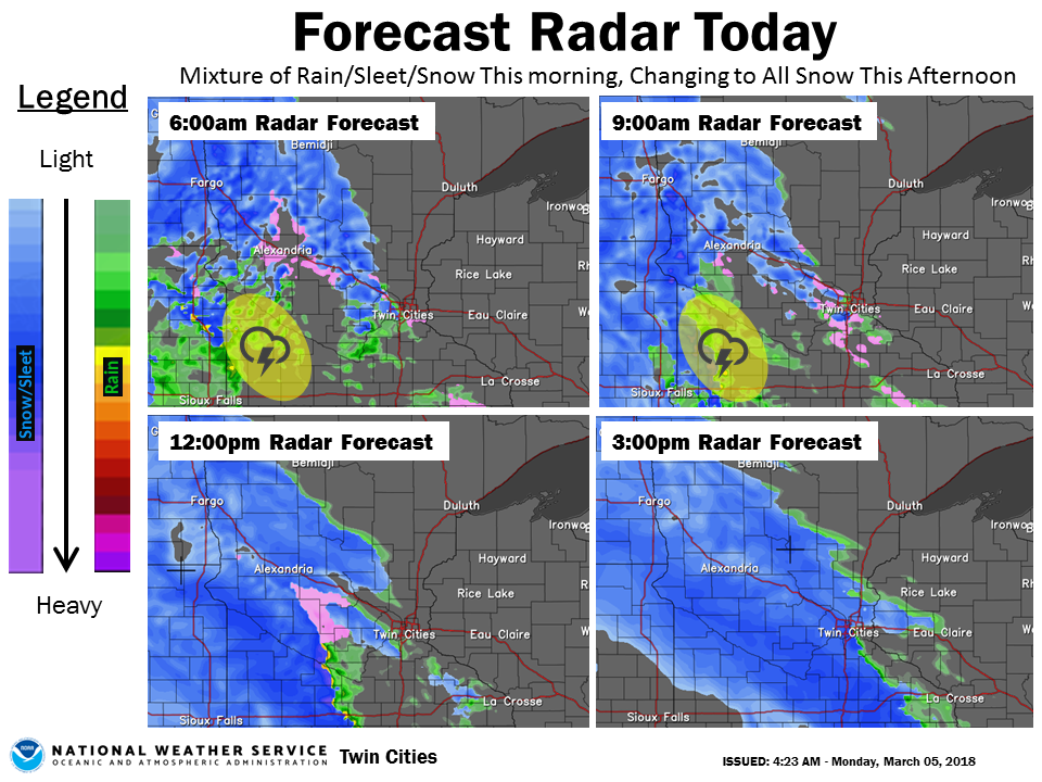
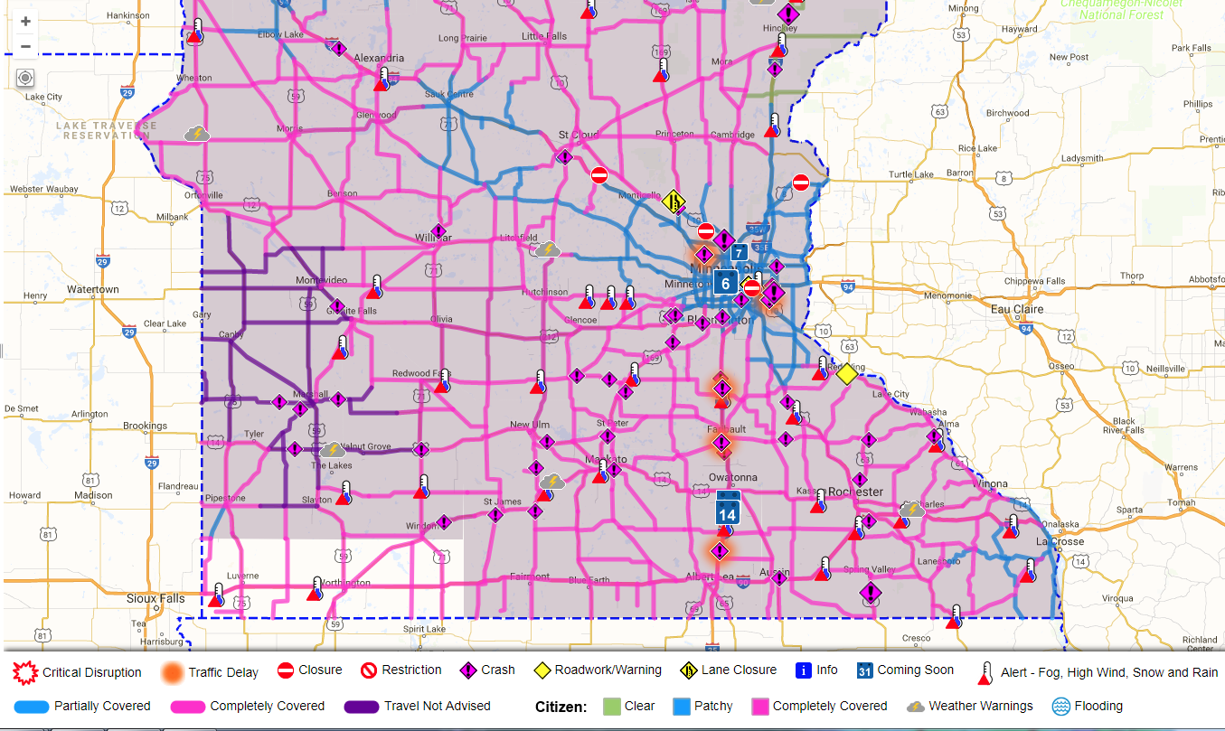
The main message was how the intensity of snow would produce hazardous travel conditions. Many schools cancelled class the night before as a result. However, in some areas of eastern Minnesota and especially western Wisconsin, accumulating snow didn't begin until early to mid afternoon due to a slower arrival. This slower arrival was well known by the early morning of March 5th and messaging began to shift to hone in on that likelihood.
Because of the timing issue with the initial warning issuance and the blotchy nature of the heavy snow totals, some negative feedback was received but it was still mostly positive.
 |
 |
 |
|
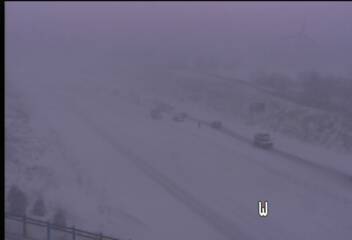
| Graphic issued early morning on March 5th showing the arrival of heavy snow. | Radar loop of the storm. | Travel conditions late afternoon, March 5th. | Multicar accident on U.S. 212 in Chaska during the evening commute. Snow rates during this time were about 2 inches per hour. |
| Impact messaging | Up to 4 points |
| Impacts were clearly conveyed and partners responded accordingly. Positive feedback was received. | 4 |
| Overall, impacts were conveyed well, but some impacts were over or underestimated. Mostly positive feedback was received. | 3 |
| Impacts could have been more clearly stated. Feedback was mixed. | 2 |
| Impacts were not clearly defined. Mostly negative feedback was received. | 1 |
| Impacts were opposite of what was forecast. Feedback was negative. | 0 |
| 3 |
 |
Media use of NWS Web News Stories is encouraged! Please acknowledge the NWS as the source of any news information accessed from this site. |
 |