
Dangerous to record breaking heat will build across the center of the nation and slowly build eastward this week. Wildfire conditions remain critical for the Southwest and portions of the Great Basin through Monday. For the northern Plains and upper Midwest, severe thunderstorms with the potential for large to very large hail and severe winds are the primary hazards. Read More >
Milwaukee/Sullivan, WI
Weather Forecast Office
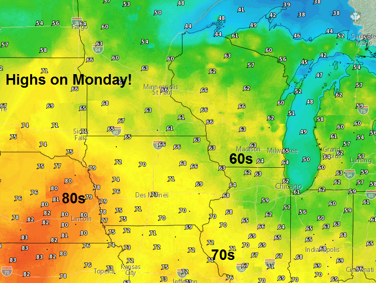
Rare is the snow pile that survived high temperatures climbing into the mid 60s on Monday! The power of that strengthening March sunshine, combined with light winds, can really push those temperatures above what is expected. There were few complaints about the unexpected warmth.
Below is a map showing those high temperatures from Monday across the Upper Midwest:
Temperatures for much of this week should average above normal. One hitch in the forecast will be later in the week, when winds turn onshore. These winds will result in areas near Lake Michigan remaining much cooler than inland areas Wednesday afternoon through Friday. Inland areas will likely rise into the lower to middle 50s, while lakeshore areas remain in the middle to upper 40s. The normal high temperatures for this week are mainly in the lower 40s.
Daytime temperatures today are expected to peak into the mid 60s once again!
Here's the Climate Prediction Center's outlook for temperatures over the next 2 weeks:
|
6-10 Day Outlook |
8-14 Day Outlook |

The best chance for showers will be tonight, as a cold front moves across southern Wisconsin. Slight chances for thunderstorms are also forecast tonight. Chances for showers will continue Wednesday into Thursday, as the front stalls to the southeast of the area. We may see some fog develop at times tonight into Wednesday as well, with winds weakening and moist air lingering over the area.
Kavinsky/Schultz/Wood/Davis
National Weather Service - Milwaukee/Sullivan, WI
Hazards
National Briefing
Hazardous Weather Outlook
Skywarn
View Local Storm Reports
Submit A Storm Report
Winter Weather
Summer Weather
Beach Hazards
Local Forecasts
Marine
Aviation
Fire
Local Text Products
Local Precip Forecast
Hourly Forecast Graphics
Forecast Discussion
Climate
Local Climate Products
Normals/Records MKE/MSN
CoCoRaHS
Historic Events For Srn WI
Lightning Plot Archive
Daily Climate Graphics
US Dept of Commerce
National Oceanic and Atmospheric Administration
National Weather Service
Milwaukee/Sullivan, WI
N3533 Hardscrabble Road
Dousman, WI 53118
262-965-2074
Comments? Questions? Please Contact Us.


