Impacts to holiday travel are expected on Friday with accumulating snowfall, and over the weekend with mostly rain expected for Christmas Day.
The first system will be a combination of warmer air spreading into the area Friday, plus a trough of low pressure moving east through the region Friday afternoon and evening. This will result in wet snow moving into southwest Wisconsin Friday morning, and expanding through the rest of Wisconsin through the afternoon. Some light rain may mix with the snow across far southeast Wisconsin. Snow will taper off from west to east late Friday evening.
The second system will be a strong low pressure system that will impact the central and northern parts of the country. Blizzard conditions are possible for the Dakotas Christmas Day. The low will bring warm and moist air northward into the Wisconsin Saturday night into Christmas Day. A cold front will then move through our area Sunday night. A wintry mix Saturday night (Christmas Eve) will transition to rain from south to north during the day Sunday (Christmas Day).
Round 1: Friday Into Friday Evening
Wet snow will spread from west to east across southern Wisconsin on Friday. Here is the latest forecast timing for when the snow will begin. Snowfall rates will be lighter at the onset, but expect a period of moderate snow during the afternoon hours, primarily from 3 to 6 pm. Temperatures will be in the lower 30s, but higher snowfall rates like a half inch per hour can lead to snow covered and slippery roads, regardless of temperatures.
Timing:

This YouTube briefing describes the timing of the moderate snow vs. the lighter snow for southern Wisconsin.
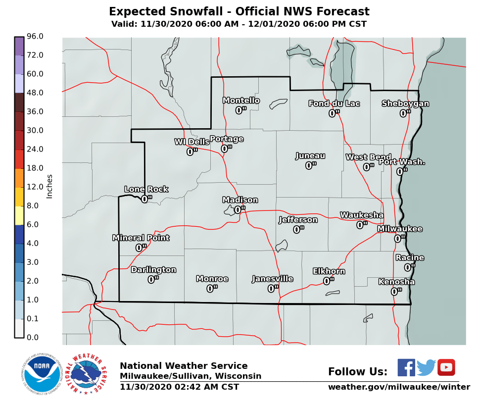
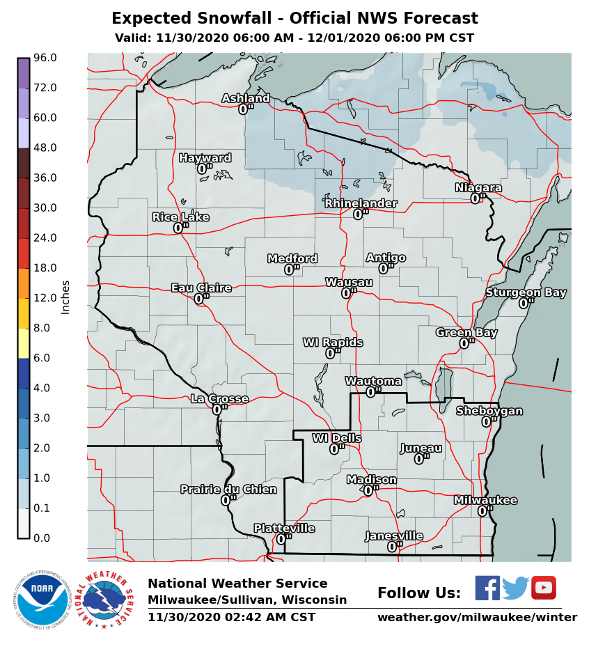
Snow accumulations will be in the 2 to 4 inch range across central Wisconsin and portions of southern Wisconsin. A Winter Weather Advisory is in effect. Highest amounts are expected from La Crosse to Wausau to north of Green Bay.
Here are the latest snowfall maps for Wisconsin through Friday night:
| Southern Wisconsin | All of Wisconsin |
 |
 |
The air will begin to dry out from west to east Friday evening, which may result in patchy light freezing drizzle occurring, before ending around midnight. The combination of the light snow and light freezing drizzle would cause slippery roads for those traveling for the start of the holiday weekend. Keep up with the latest forecasts for this first round of precipitation.
Here are the latest probabilistic snowfall graphics for southern Wisconsin valid through Friday night. Check out this YouTube video that explains how to interpret these graphics.
or post them on Facebook or Twitter. Reports will be added to this Snow Report graphic.
Round 2: Saturday Night Into Monday
Surface temperatures across Wisconsin will be below freezing Saturday night into the morning hours on Christmas, and this will allow for chances of light freezing rain and patchy light freezing drizzle over southern Wisconsin. This may result in a light glazing of area roads.
As the warmer air continues to push into the area Christmas Day, the precipitation should change to all rain, from south to north, by midday. The rain should continue into Sunday night, before tapering off Monday morning.
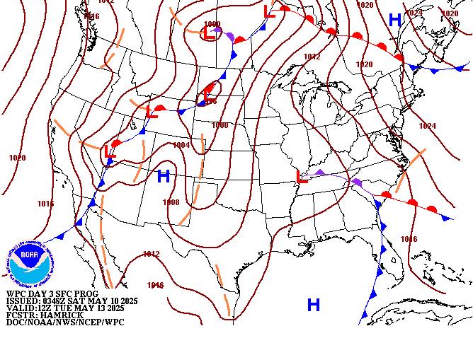
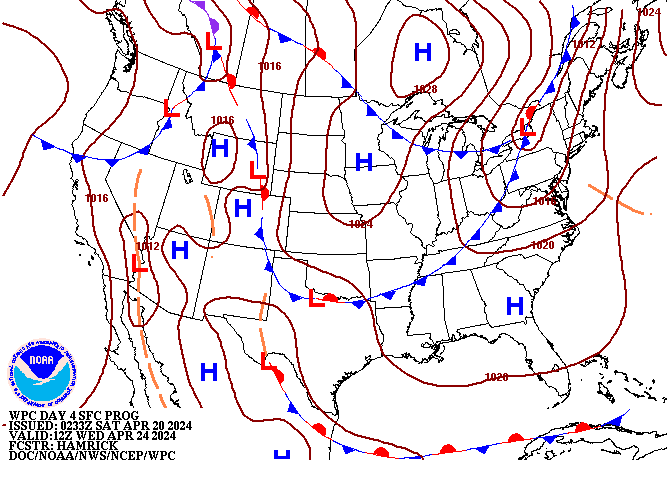
Here is a map (from the Weather Prediction Center) showing the rainfall forecast for Christmas Day into Monday morning:

Southern Wisconsin may see between about 0.40 inches to 0.60 inches of rainfall with this system.
Further to the north, a mix of light rain, light freezing rain, light sleet and light snow are forecast for Christmas Day, lingering into Sunday night before slowly tapering off on Monday. This may result in a combination of light snow and ice accumulations, and more travel impacts for this portion of the holiday weekend.
Here are some maps (from the Weather Prediction Center) showing the track of the low pressure system through the region:
| Christmas Day 6 AM | Monday 6 AM | Tuesday 6 AM |
 |
 |
 |
Things may change as we get closer to these events, so continue to monitor the latest forecasts. Those traveling this weekend should prepare for the likelihood of slippery roads.
Click here for the latest Hazardous Weather Outlook.
Click here for our Winter Weather page.
Click here for the latest Wisconsin road conditions (from Wisconsin DOT).
Here are the latest local and regional radar images:
| Local Radar | Regional Radar - West View | Regional Radar - East View |
 |
 |
 |
Here is the latest Weather Story and Winter Weather Headlines across the region:
| Weather Story | Winter Weather Headlines |
 |
 |
Wood/MRC
NWS Milwaukee/Sullivan, WI

