September 10-11, 2022 Heavy Rain and Flooding
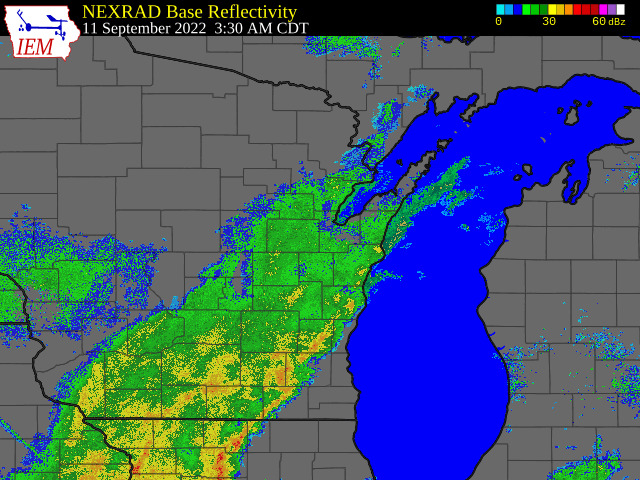
A slow moving closed low moved across southern Lake Michigan and brought a long period of heavy rain. Rain started during the evening of September 10 across southwest and south-central Wisconsin as a cold front moved southeast across the state. It stalled and weakened a closed low pressure system developed over southern Lake Michigan later on September 10. Rain from the closed low then impacted southern Wisconsin from late on the 10th to the morning of September 12. In far eastern Wisconsin, the rain started around 6 am on the 11th resulting in most of the rainfall occurring in about a 24 hour period.
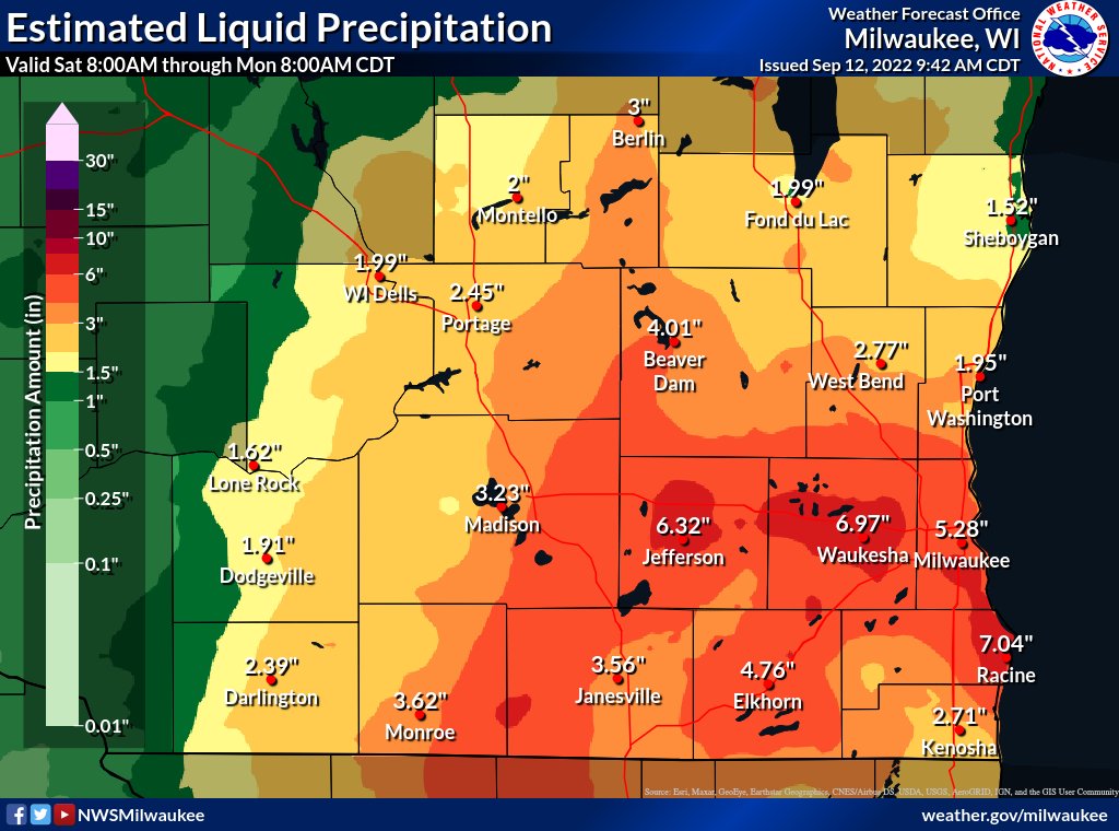
| Rain was moderate to heavy for a 24 to 36 hour time period and amounts ranged from 1 to 2 inches west of Madison, 4 to 7 inches across Jefferson, Waukesha, Milwaukee, Racine, and Walworth counties. Highest amounts of 7 to 9.6 inches fell in eastern Racine county where two different bands of heavy rain moved overhead. Other parts of southeast Wisconsin received 3 to 4 inches. Rain rates were 0.5 to 1 inch an hour at times in the heaviest rain bands. A few locations broke records for greatest 1 day or 2 day rainfall amounts for Sep 11 or the entire month of September. |
Radar Loop 3:30 AM Sunday, September 11 to 4 AM Monday, September 12 |
There were several areas with standing water on roads, especially across Waukesha and Racine counties. However, mostly dry weather prevailed during the week prior to this storm so the ground was somewhat dry and able to soak up some of the rain which helped to limit further flooding issues. It was also fairly dry in the month prior to this storm and subsoil moisture was somewhat low.
Flooding
.
Hydrographs
 |
 |
 |
 |
|
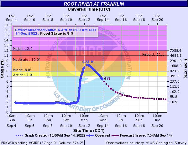
Root River at Franklin Click HERE for latest data |
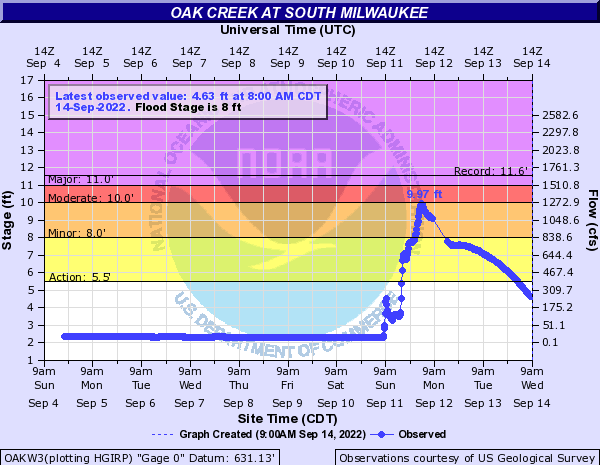
Oak Creek at South Milwaukee Click HERE for latest reading |
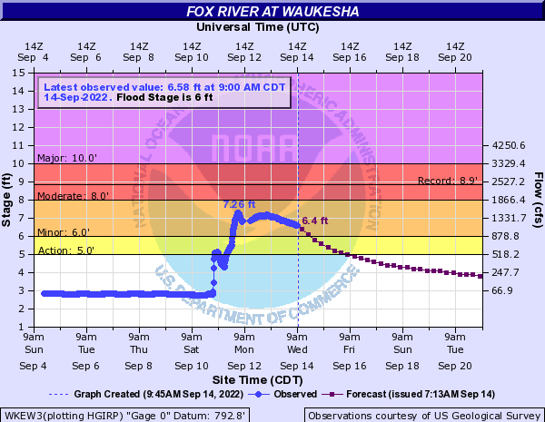
Fox River at Waukesha Click HERE for latest reading |
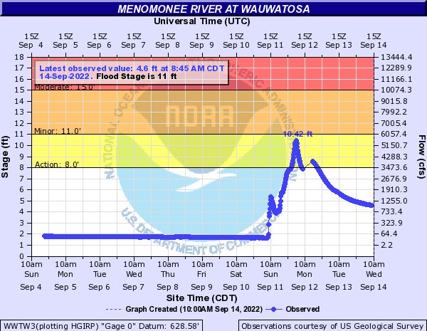
Menomonee River at Wauwatosa Click HERE for latest reading |
Radar/Photos
 |
 |
||
| 2 Day Rainfall Total | 24 Hour Radar Loop | Caption | Caption |
Storm Reports
0900 AM     FLOOD            3 SSW PEWAUKEE          43.05N 88.29W
09/12/2022                   WAUKESHA           WI   EMERGENCY MNGR

            SEVERAL ROADS WITH STANDING WATER THROUGHOUT
            WAUKESHA COUNTY. INCLUDING I 94 AT HWY T.

1000 PM     FLOOD            1 NNW ELMWOOD PARK      42.71N 87.83W
09/11/2022                   RACINE             WI   911 CALL CENTER

            DISPATCH REPORTS OF A FEW ROADS WITH
            STANDING WATER ACROSS RACINE COUNTY.

0900 AM     FLOOD            1 WSW GREENDALE         42.93N 88.02W
09/12/2022                   MILWAUKEE          WI   911 CALL CENTER

            STANDING WATER ON ROOT RIVER PARKWAY.
3 Day Storm Totals
| Battan International Airport in Racine | 8.14" |
| General Mitchell International Airport in Milwaukee | 5.57" |
| Fond du Lac County Airport | 3.28" |
| National Weather Service Milwaukee/Sullivan | 5.01" |
| Dane County Regional Airport in Madison | 3.18" |
| Kenosha Regional Airport | 2.93" |
| Sheboygan County Memorial Airport | 1.81" |
| Tri County Regional Airport in Lone Rock | 1.60" |
24 Hour Totals as of 9/12/22 10:54 am CDT
...24 HOUR PRECIPITATION REPORTS...

LOCATION                     AMOUNT    TIME/DATE       PROVIDER

...WISCONSIN...

...COLUMBIA COUNTY...
COLUMBUS 1.2 S               2.34 IN   0700 AM 09/12   COCORAHS

...DANE COUNTY...
STOUGHTON                    4.37 IN   0730 AM 09/12   COOP
DEERFIELD 0.6 N              4.03 IN   0650 AM 09/12   COCORAHS
COTTAGE GROVE 2.2 E          3.31 IN   0700 AM 09/12   COCORAHS
1 ESE SUN PRAIRIE            2.72 IN   0705 AM 09/12   COCORAHS
FITCHBURG 1.1 NW             2.66 IN   0700 AM 09/12   COCORAHS

...DODGE COUNTY...
WATERTOWN 1.2 NNE            4.53 IN   0750 AM 09/12   COCORAHS
COLUMBUS 4.8 ENE             4.20 IN   0800 AM 09/12   COCORAHS
BEAVER DAM 1.4 SSW           3.75 IN   0800 AM 09/12   COCORAHS
IXONIA 5.0 NE                3.70 IN   0800 AM 09/12   COCORAHS
RANDOLPH 1.2 SE              3.25 IN   0800 AM 09/12   COCORAHS

...FOND DU LAC COUNTY...
ST. PETER                    2.42 IN   0700 AM 09/12   UCOOP
CAMPBELLSPORT                2.27 IN   1035 AM 09/12   CWOP
1.8 E SOUTH BYRON            2.20 IN   1200 AM 09/12   COOP
FOND DU LAC 1.7 E            2.20 IN   0700 AM 09/12   COCORAHS
RIPON 2.1 S                  2.18 IN   0600 AM 09/12   COCORAHS

...GREEN COUNTY...
MONROE 5.1 NE                2.28 IN   0800 AM 09/12   COCORAHS
1.2 W MONROE                 2.23 IN   0630 AM 09/12   COOP
NEW GLARUS 0.1 W             2.07 IN   0700 AM 09/12   COCORAHS
JUDA 1.3 WNW                 2.06 IN   0700 AM 09/12   COCORAHS
NEW GLARUS 1.9 NNW           1.95 IN   0700 AM 09/12   COCORAHS

...GREEN LAKE COUNTY...
GREEN LAKE 0.8 E             2.16 IN   0700 AM 09/12   COCORAHS

...IOWA COUNTY...
MINERAL POINT 7.3 ENE        1.22 IN   0700 AM 09/12   COCORAHS

...JEFFERSON COUNTY...
JOHNSON CREEK 3.2 NW         5.45 IN   0700 AM 09/12   COCORAHS
LAKE MILLS 4.3 N             5.03 IN   0700 AM 09/12   COCORAHS
JEFFERSON-WWTP               4.76 IN   0700 AM 09/12   COOP
0.5 SW LAKE MILLS            4.68 IN   0730 AM 09/12   COOP
LAC LABELLE 1.2 SW           4.60 IN   0650 AM 09/12   COCORAHS
WATERTOWN 0.7 SSW            4.42 IN   0600 AM 09/12   COCORAHS
WATERTOWN 0.8 S              4.30 IN   0700 AM 09/12   COCORAHS
FORT ATKINSON 0.3 SSE        4.10 IN   0800 AM 09/12   COCORAHS
WATERLOO                     3.87 IN   0739 AM 09/12   COOP
JOHNSON CREEK 2.7 SSW        3.81 IN   0430 AM 09/12   COCORAHS

...KENOSHA COUNTY...
KENOSHA-WWTP                 4.18 IN   1200 AM 09/12   COOP
2 ENE ANTIOCH                3.48 IN   0700 AM 09/12   COCORAHS
2 SW BOHNERS LAKE            3.47 IN   0700 AM 09/12   COCORAHS
KENOSHA 3.1 SSE              3.43 IN   0700 AM 09/12   COCORAHS
KENOSHA 3.8 WSW              3.33 IN   0600 AM 09/12   COCORAHS

...LAFAYETTE COUNTY...
SOUTH WAYNE 3.9 SSW          1.12 IN   0600 AM 09/12   COCORAHS

...MARQUETTE COUNTY...
NESHKORO 5.0 SSE             1.37 IN   0700 AM 09/12   COCORAHS

...MILWAUKEE COUNTY...
CUDAHY 1.3 N                 7.15 IN   0800 AM 09/12   COCORAHS
FRANKLIN 1.2 ENE             6.90 IN   0703 AM 09/12   COCORAHS
1.9 SE SOUTH MILWAUKEE       6.28 IN   0900 AM 09/12   UCOOP
GREENDALE 1.0 ENE            6.22 IN   0700 AM 09/12   COCORAHS
CUDAHY 0.8 SE                6.10 IN   0800 AM 09/12   COCORAHS
MILWAUKEE 5.4 SSE            5.95 IN   0701 AM 09/12   COCORAHS
GREENDALE                    5.85 IN   1037 AM 09/12   CWOP
OAK CREEK 2.2 SE             5.78 IN   0630 AM 09/12   COCORAHS
OAK CREEK                    5.77 IN   1035 AM 09/12   CWOP
FRANKLIN 3.7 NW              5.75 IN   0700 AM 09/12   COCORAHS

...OZAUKEE COUNTY...
CEDARBURG 1.2 SSW            3.42 IN   0700 AM 09/12   COCORAHS
MEQUON 2.7 ENE               3.00 IN   0700 AM 09/12   COCORAHS
PORT WASHINGTON              2.87 IN   1039 AM 09/12   AWS
CEDARBURG                    2.70 IN   1037 AM 09/12   CWOP
WEST BEND 7.3 E              2.48 IN   0700 AM 09/12   COCORAHS

...RACINE COUNTY...
RACINE 1.4 NNW               9.76 IN   0500 AM 09/12   COCORAHS
RACINE 5.9 N                 7.77 IN   0621 AM 09/12   COCORAHS
RACINE 5.2 N                 7.75 IN   0545 AM 09/12   COCORAHS
RACINE 2.3 WSW               7.35 IN   0700 AM 09/12   COCORAHS
NORTH BAY 0.5 WSW            6.83 IN   0700 AM 09/12   COCORAHS
RACINE                       6.75 IN   0800 AM 09/12   COOP
RACINE 2.4 S                 6.04 IN   0700 AM 09/12   COCORAHS
RACINE-BATTEN AIRPORT        5.98 IN   1012 AM 09/12   ASOS
STURTEVANT 0.8 S             5.65 IN   0600 AM 09/12   COCORAHS
RACINE 3.0 WNW               5.56 IN   0700 AM 09/12   COCORAHS

...ROCK COUNTY...
JANESVILLE 3.1 W             3.53 IN   0700 AM 09/12   COCORAHS
3 E EDGERTON                 3.52 IN   0700 AM 09/12   COCORAHS
MILTON-WWTP                  3.26 IN   0700 AM 09/12   COOP
JANESVILLE 2.9 S             2.95 IN   0800 AM 09/12   COCORAHS
0.5 NE SOUTH BELOIT          2.90 IN   0530 AM 09/12   COOP

...SAUK COUNTY...
PRAIRIE DU SAC 0.6 SSE       2.34 IN   0637 AM 09/12   COCORAHS

...SHEBOYGAN COUNTY...
GLENBEULAH 4.0 WSW           1.90 IN   0700 AM 09/12   COCORAHS

...WALWORTH COUNTY...
LAKE GENEVA 0.6 ENE          4.73 IN   0700 AM 09/12   COCORAHS
FONTANA 0.3 SSE              4.60 IN   0700 AM 09/12   COCORAHS
MUKWONAGO 3.4 SW             4.52 IN   0600 AM 09/12   COCORAHS
GENOA CITY 2.7 NW            4.50 IN   0657 AM 09/12   COCORAHS
PELL LAKE                    4.29 IN   1035 AM 09/12   CWOP

...WASHINGTON COUNTY...
1.4 S GERMANTOWN             5.48 IN   0940 AM 09/12   COOP
HUBERTUS 3.1 E               4.49 IN   0600 AM 09/12   COCORAHS
1.9 SE HUBERTUS              4.32 IN   0600 AM 09/12   COOP
WEST BEND 1.4 W              3.92 IN   0800 AM 09/12   COCORAHS
JACKSON 1 SW                 3.83 IN   0600 AM 09/12   COOP

...WAUKESHA COUNTY...
NEW BERLIN 0.6 ESE           7.10 IN   0700 AM 09/12   COCORAHS
WAUKESHA 1.7 ESE             6.72 IN   0658 AM 09/12   COCORAHS
OCONOMOWOC 6.3 SSE           6.20 IN   0700 AM 09/12   COCORAHS
OCONOMOWOC 4.5 SE            6.10 IN   0700 AM 09/12   COCORAHS
2.9 W BROOKFIELD             5.81 IN   0821 AM 09/12   COOP
WALES 0.7 NE                 5.77 IN   0700 AM 09/12   COCORAHS
NEW BERLIN 1.9 WNW           5.62 IN   0700 AM 09/12   COCORAHS
WAUKESHA 1.6 NW              5.60 IN   0700 AM 09/12   COCORAHS
WAUKESHA 1.6 NW              5.58 IN   0830 AM 09/12   COCORAHS
...2 DAY PRECIPITATION REPORTS...

LOCATION                     AMOUNT    TIME/DATE       PROVIDER

...WISCONSIN...

...COLUMBIA COUNTY...
COLUMBUS 1.2 S               3.61 IN   0700 AM 09/12   COCORAHS
FRIESLAND                    3.55 IN   0645 AM 09/12   COCORAHS
RANDOLPH 2.2 NNW             3.48 IN   0800 AM 09/12   COCORAHS
PARDEEVILLE                  2.75 IN   1014 AM 09/12   RAWS
PORTAGE 7.2 SW               2.63 IN   0700 AM 09/12   COCORAHS


...DANE COUNTY...
DEERFIELD 0.6 N              5.03 IN   0650 AM 09/12   COCORAHS
STOUGHTON                    4.72 IN   0730 AM 09/12   COOP
COTTAGE GROVE 2.2 E          4.50 IN   0700 AM 09/12   COCORAHS
MCFARLAND 1.3 NE             4.25 IN   0700 AM 09/12   COCORAHS
1 ESE SUN PRAIRIE            4.02 IN   0705 AM 09/12   COCORAHS
MADISON 3.2 ENE              3.87 IN   0700 AM 09/12   COCORAHS
OREGON 0.4 SSW               3.81 IN   0830 AM 09/12   COCORAHS
MONONA                       3.79 IN   1048 AM 09/12   CWOP
BELLEVILLE                   3.79 IN   1046 AM 09/12   CWOP
MADISON SOUTH-UW ARBORETUM   3.75 IN   0847 AM 09/12   COOP

...DODGE COUNTY...
COLUMBUS 4.8 ENE             5.48 IN   0800 AM 09/12   COCORAHS
BEAVER DAM 1.4 SSW           5.25 IN   0800 AM 09/12   COCORAHS
WATERTOWN 1.2 NNE            5.08 IN   0750 AM 09/12   COCORAHS
IXONIA 5.0 NE                4.35 IN   0800 AM 09/12   COCORAHS
RANDOLPH 1.2 SE              4.35 IN   0800 AM 09/12   COCORAHS
BEAVER DAM 3.9 E             3.88 IN   0700 AM 09/12   COCORAHS
BEAVER DAM                   3.70 IN   1045 AM 09/12   CWOP
BEAVER DAM 2.4 WNW           3.52 IN   0700 AM 09/12   COCORAHS
2.3 W BEAVER DAM             3.52 IN   0700 AM 09/12   COOP
CLYMAN                       3.24 IN   0700 AM 09/12   COOP

...FOND DU LAC COUNTY...
RIPON 2.1 S                  3.03 IN   0600 AM 09/12   COCORAHS
ST. PETER                    3.01 IN   0700 AM 09/12   UCOOP
FOND DU LAC 1.7 E            2.90 IN   0700 AM 09/12   COCORAHS
CAMPBELLSPORT                2.73 IN   1050 AM 09/12   CWOP
FOND DU LAC 1 SW             2.68 IN   0700 AM 09/12   UCOOP

...GREEN COUNTY...
MONROE 5.1 NE                4.08 IN   0800 AM 09/12   COCORAHS
NEW GLARUS 0.1 W             3.51 IN   0700 AM 09/12   COCORAHS
JUDA 1.3 WNW                 3.46 IN   0700 AM 09/12   COCORAHS
1.2 W MONROE                 3.45 IN   0630 AM 09/12   COOP
MONTICELLO 2.2 SE            3.23 IN   0800 AM 09/12   COCORAHS

...GREEN LAKE COUNTY...
0.6 SW MARKESAN              3.40 IN   0630 AM 09/12   COOP
GREEN LAKE 0.8 E             3.14 IN   0700 AM 09/12   COCORAHS
PRINCETON 3.4 SE             3.12 IN   0700 AM 09/12   COCORAHS
BERLIN                       2.29 IN   1049 AM 09/12   AWS

...IOWA COUNTY...
MINERAL POINT 7.3 ENE        2.05 IN   0700 AM 09/12   COCORAHS

...JEFFERSON COUNTY...
JEFFERSON-WWTP               6.26 IN   0700 AM 09/12   COOP
JOHNSON CREEK 3.2 NW         5.95 IN   0700 AM 09/12   COCORAHS
LAKE MILLS 4.3 N             5.87 IN   0700 AM 09/12   COCORAHS
LAC LABELLE 1.2 SW           5.49 IN   0650 AM 09/12   COCORAHS
FORT ATKINSON 0.3 SSE        5.20 IN   0800 AM 09/12   COCORAHS
WATERLOO                     5.02 IN   0742 AM 09/12   COCORAHS
WATERTOWN 0.8 S              4.92 IN   0700 AM 09/12   COCORAHS
WATERTOWN 0.7 SSW            4.88 IN   0600 AM 09/12   COCORAHS
WATERLOO                     4.76 IN   1049 AM 09/12   AWS
0.5 SW LAKE MILLS            4.68 IN   0730 AM 09/12   COOP

...KENOSHA COUNTY...
KENOSHA-WWTP                 4.18 IN   1200 AM 09/12   COOP
2 ENE ANTIOCH                3.48 IN   0700 AM 09/12   COCORAHS
2 SW BOHNERS LAKE            3.47 IN   0700 AM 09/12   COCORAHS
KENOSHA 3.1 SSE              3.43 IN   0700 AM 09/12   COCORAHS
KENOSHA 3.8 WSW              3.33 IN   0600 AM 09/12   COCORAHS
PLEASANT PRAIRIE 3.3 NW      3.13 IN   0800 AM 09/12   COCORAHS
TWIN LAKES 1.5 NE            3.12 IN   0700 AM 09/12   COCORAHS
PLEASANT PRAIRIE 1.4 ESE     3.04 IN   0600 AM 09/12   COCORAHS
KENOSHA 1.7 S                2.85 IN   0630 AM 09/12   COCORAHS
KENOSHA AIRPORT              2.78 IN   1037 AM 09/12   ASOS

...LAFAYETTE COUNTY...
SOUTH WAYNE 3.9 SSW          2.40 IN   0600 AM 09/12   COCORAHS

...MARQUETTE COUNTY...
NESHKORO 5.0 SSE             2.40 IN   0700 AM 09/12   COCORAHS

...MILWAUKEE COUNTY...
CUDAHY 1.3 N                 7.15 IN   0800 AM 09/12   COCORAHS
FRANKLIN 1.2 ENE             6.90 IN   0703 AM 09/12   COCORAHS
GREENDALE                    6.66 IN   1047 AM 09/12   CWOP
1.9 SE SOUTH MILWAUKEE       6.59 IN   0900 AM 09/12   UCOOP
GREENDALE 1.0 ENE            6.22 IN   0700 AM 09/12   COCORAHS
OAK CREEK                    6.21 IN   1045 AM 09/12   CWOP
CUDAHY 0.8 SE                6.10 IN   0800 AM 09/12   COCORAHS
FRANKLIN 3.7 NW              6.01 IN   0700 AM 09/12   COCORAHS
MILWAUKEE 5.4 SSE            5.95 IN   0701 AM 09/12   COCORAHS
WEST ALLIS 0.7 SSE           5.94 IN   0800 AM 09/12   COCORAHS

...OZAUKEE COUNTY...
CEDARBURG 1.2 SSW            4.19 IN   0700 AM 09/12   COCORAHS
MEQUON 2.7 ENE               4.00 IN   0700 AM 09/12   COCORAHS
PORT WASHINGTON              3.83 IN   1049 AM 09/12   AWS
SAUKVILLE 0.9 SSW            3.39 IN   0700 AM 09/12   COCORAHS
WEST BEND 7.3 E              3.33 IN   0700 AM 09/12   COCORAHS

...RACINE COUNTY...
RACINE 1.4 NNW               9.76 IN   0500 AM 09/12   COCORAHS
RACINE 5.9 N                 7.84 IN   0621 AM 09/12   COCORAHS
RACINE 5.2 N                 7.75 IN   0545 AM 09/12   COCORAHS
RACINE 2.3 WSW               7.35 IN   0700 AM 09/12   COCORAHS
RACINE-BATTEN AIRPORT        7.07 IN   1012 AM 09/12   ASOS
NORTH BAY 0.5 WSW            6.83 IN   0700 AM 09/12   COCORAHS
RACINE                       6.77 IN   0800 AM 09/12   COOP
RACINE 2.4 S                 6.04 IN   0700 AM 09/12   COCORAHS
STURTEVANT 0.8 S             5.65 IN   0600 AM 09/12   COCORAHS
RACINE 3.0 WNW               5.62 IN   0700 AM 09/12   COCORAHS

...ROCK COUNTY...
3 E EDGERTON                 4.89 IN   0700 AM 09/12   COCORAHS
JANESVILLE 3.1 W             4.62 IN   0700 AM 09/12   COCORAHS
MILTON-WWTP                  4.06 IN   0700 AM 09/12   COOP
JANESVILLE 2.9 S             4.05 IN   0800 AM 09/12   COCORAHS
BELOIT 3.3 E                 4.04 IN   0700 AM 09/12   COCORAHS

...SAUK COUNTY...
0.9 SW SAUK CITY             2.38 IN   0616 AM 09/12   COOP
PRAIRIE DU SAC 0.6 SSE       2.34 IN   0637 AM 09/12   COCORAHS
BARABOO                      2.17 IN   1046 AM 09/12   CWOP
BARABOO 6.0 NNE              2.04 IN   0700 AM 09/12   COCORAHS
ROCK SPRINGS 2.8 WSW         1.82 IN   0700 AM 09/12   COCORAHS

...SHEBOYGAN COUNTY...
RANDOM LAKE-COCORAHS         2.28 IN   0700 AM 09/12   COCORAHS
GLENBEULAH 4.0 WSW           1.90 IN   0700 AM 09/12   COCORAHS
SHEBOYGAN 3.7 NW             1.73 IN   0800 AM 09/12   COCORAHS
SHEBOYGAN FALLS 0.9 ENE      1.69 IN   0700 AM 09/12   COCORAHS
PLYMOUTH                     1.65 IN   0730 AM 09/12   COOP

...WALWORTH COUNTY...
FONTANA 0.3 SSE              5.87 IN   0700 AM 09/12   COCORAHS
MUKWONAGO 3.4 SW             5.77 IN   0600 AM 09/12   COCORAHS
EAST TROY                    5.34 IN   1045 AM 09/12   CWOP
TROY CENTER 1.1 WNW          5.24 IN   0700 AM 09/12   COCORAHS
ELKHORN 5.3 N                5.11 IN   0700 AM 09/12   COCORAHS
LAKE GENEVA 0.6 ENE          4.79 IN   0700 AM 09/12   COCORAHS
ELKHORN 0.4 ESE              4.76 IN   0530 AM 09/12   COCORAHS
PELL LAKE                    4.61 IN   1045 AM 09/12   CWOP
GENOA CITY 2.7 NW            4.54 IN   0657 AM 09/12   COCORAHS
ELKHORN 1.1 WSW              4.42 IN   0700 AM 09/12   COCORAHS

...WASHINGTON COUNTY...
HUBERTUS 3.1 E               5.67 IN   0600 AM 09/12   COCORAHS
1.4 S GERMANTOWN             5.48 IN   0940 AM 09/12   COOP
COLGATE                      5.15 IN   1045 AM 09/12   CWOP
1.9 SE HUBERTUS              4.92 IN   0600 AM 09/12   COOP
JACKSON 0.5 SSE              4.08 IN   0700 AM 09/12   COCORAHS
JACKSON 1 SW                 3.94 IN   0600 AM 09/12   COOP
WEST BEND 1.4 W              3.92 IN   0800 AM 09/12   COCORAHS
JACKSON-COCORAHS             3.83 IN   0600 AM 09/12   COCORAHS
RICHFIELD 2.8 WNW            3.77 IN   0800 AM 09/12   COCORAHS
JACKSON 0.9 SSE              3.73 IN   0600 AM 09/12   COCORAHS

...WAUKESHA COUNTY...
2.9 W BROOKFIELD             7.81 IN   0821 AM 09/12   COOP
WAUKESHA                     7.46 IN   1045 AM 09/12   CWOP
WALES 0.7 NE                 7.30 IN   0700 AM 09/12   COCORAHS
NEW BERLIN 0.6 ESE           7.20 IN   0700 AM 09/12   COCORAHS
WAUKESHA 1.6 NW              7.14 IN   0830 AM 09/12   COCORAHS
OCONOMOWOC 6.3 SSE           7.10 IN   0700 AM 09/12   COCORAHS
MENOMONEE FALLS 1.7 ENE      6.75 IN   0900 AM 09/12   COCORAHS
WAUKESHA 1.7 ESE             6.72 IN   0658 AM 09/12   COCORAHS
DOUSMAN 0.9 SSE              6.68 IN   0700 AM 09/12   COCORAHS
BROOKFIELD 2.5 WNW           6.66 IN   0710 AM 09/12   COCORAHS

OBSERVATIONS ARE COLLECTED FROM A VARIETY OF SOURCES WITH VARYING
EQUIPMENT AND EXPOSURES. WE THANK ALL VOLUNTEER WEATHER OBSERVERS
FOR THEIR DEDICATION. NOT ALL DATA LISTED ARE CONSIDERED OFFICIAL.
Records
2 ENE Elmwood Park (Racine Co) co-op observer reports M6.75 inches. This represents the largest single day total in this stations history which dates back to 5/1/1896. The previous record was 4.80 inches which occurred on 4/5/1947. The two day total for this event was 6.77 inches.
Mitchel Field (Milwaukee Co) M4.78 inches ending at midnight Sep 11 breaks the daily record precipitation for the a single day in the month of September for Milwaukee. The previous September record was 4.32 on 9/8/1941. The previous Sep 11 record was 2.96 inches set in 2000.
1 SW Waukesha co-op observer reports M5.61. This is a single day record precipitation total for that site. Previous record was 5.09 on 7/18/1952. Records go back to 1/4/1893. 2 Day total is 7.91 inches.
The Fox River in Waukesha crested at 7.28 ft, which is the 7th highest on record. Records go back to 1960.
The Root River in Franklin crested at 9.29 ft, which was the 8th highest on record. Records go back to 1960.
Oak Creek in South Milwaukee crested at 9.97 ft which was the 3rd highest on record. Records go back to 1964.
 |
Media use of NWS Web News Stories is encouraged! Please acknowledge the NWS as the source of any news information accessed from this site. |
|

